|
Antsalova District
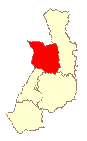
Antsalova is a district in western Madagascar. It is a part of Melaky Region and borders the districts of Maintirano in north, Morafenobe in northeast, Miandrivazo in east and Belon'i Tsiribihina in south. The area is and the population was estimated to be 30,062 in 2001. The district is crossed by the National Road No.8, though it is practicable only in the dry season. Communes The district is further divided into five communes: * Antsalova * Bekopaka * Masoarivo * Soahany * Trangahy Rivers The Manambolo River ''For the rural municipality, see Manambolo (other)'' The Manambolo River is a river in the highlands of western Madagascar of 370 km. It crosses the Tsingy de Bemaraha Strict Nature Reserve and the Maningoza Reserve. The unpaved Rou .... References Districts of Melaky {{Melaky-geo-stub ... [...More Info...] [...Related Items...] OR: [Wikipedia] [Google] [Baidu] |
Antsalova
Antsalova is a town and commune ( mg, kaominina) in western Madagascar. It belongs to the district of Antsalova, which is a part of Melaky Region. The population of the commune was estimated to be approximately 58,280 in 2018. Antsalova is served by a local Antsalova Airport. Primary and junior level secondary education are available in town. The town provides access to hospital services to its citizens. Farming and raising livestock provides employment for 20% and 76% of the working population. The most important crop is rice, while other important products are maize and cassava. Services provide employment for 1% of the population. Additionally fishing employs 3% of the population. Roads *The Nationale Road 8a leads northwards to Maintirano. See also The Maningoza Reserve Maningoza Special Reserve is a wildlife reserve in Madagascar. It was created in 1956 to protect the many endemic plants and animals, and it also contains some of the last remaining areas of dry deci ... [...More Info...] [...Related Items...] OR: [Wikipedia] [Google] [Baidu] |
Regions Of Madagascar
Madagascar is divided into 23 regions (''faritra''). These formerly second-tier administrative divisions became first-level administrative divisions when the former six provinces were dissolved on 4 October 2009. Elections Elections for the regional councils were held on 16 March 2008. See also * Subdivisions of Madagascar * Provinces of Madagascar * Districts of Madagascar *List of regions of Madagascar by Human Development Index * List of cities in Madagascar References Sources * Population, area: ''Madagascar: Profil des marchés pour les évaluations d’urgence de la sécurité alimentaire'* (in French:Découpage Territorial - L'Express.mg Regions of Madagascar, Subdivisions of Madagascar Madagascar, Regions Madagascar 2 ''Madagascar: Escape 2 Africa'' (also known as ''Madagascar 2: Escape to Africa'') is a 2008 American computer-animated adventure comedy film produced by DreamWorks Animation and distributed by Paramount Pictures. It is the sequel ... [...More Info...] [...Related Items...] OR: [Wikipedia] [Google] [Baidu] |
Melaky Region
Melaky is a region in northwestern Madagascar. It borders Boeny Region in northeast, Betsiboka in east, Bongolava in southeast and Menabe in south. The capital of the region is Maintirano. The population was estimated to be 309,805 in 2018 within the area of . Melaky has the smallest population and the smallest population density of all Malagasy regions. Administrative divisions Melaky Region is divided into five districts, which are sub-divided into 32 communes. * Ambatomainty District - 5 communes * Antsalova District - 5 communes * Besalampy District - 6 communes * Maintirano District - 14 communes * Morafenobe District - 4 communes Transport Airports *Ambatomainty Airport *Antsalova Airport * Besalampy Airport *Maintirano Airport *Morafenobe Airport *Tambohorano Airport Protected Areas The Maningoza Reserve and the Bemarivo Reserve are located in the Melaky region. * Beanka New Protected Area * Bemaraha National Park *Part of Ambohijanahary Reserve * Tsimembo-Manambolomaty ... [...More Info...] [...Related Items...] OR: [Wikipedia] [Google] [Baidu] |
Sakalava People
The Sakalava are an ethnic group of Madagascar. They are found on the western and northwest region of the island, in a band along the coast. The Sakalava are one of the smaller ethnic groups, constituting about 6.2 percent of the total population, that is over 1,210,000 in 2014. Their name means "people of the long valleys." They occupy the western edge of the island from Toliara in the south to the Sambirano River in the north. Ethnic identity The Sakalava denominate a number of smaller ethnic groups that once comprised an empire, rather than an ethnic group in its own right. The origin of the word ''Sakalava'' itself is still subject to controversy, as well as its actual meaning. The most common explanation is the modern Malagasy translation of Sakalava meaning long ravines, denoting the relatively flat nature of the land in western Madagascar. Another theory is that the word is possibly from the Arabic ''saqaliba'', which is in turn derived from Late Latin ''sclavus'', meani ... [...More Info...] [...Related Items...] OR: [Wikipedia] [Google] [Baidu] |
East Africa Time
East Africa Time, or EAT, is a time zone used in eastern Africa. The time zone is three hours ahead of UTC ( UTC+03:00), which is the same as Moscow Time, Arabia Standard Time, Further-eastern European Time and Eastern European Summer Time. As this time zone is predominantly in the equatorial region, there is no significant change in day length throughout the year and so daylight saving time is not observed. East Africa Time is observed by the following countries: * * * * * * * * * See also *Moscow Time, an equivalent time zone covering Belarus, Turkey and most of European Russia, also at UTC+03:00 *Arabia Standard Time, an equivalent time zone covering Bahrain, Iraq, Kuwait, Qatar, Saudi Arabia and Yemen, also at UTC+03:00 *Eastern European Summer Time, an equivalent time zone covering European and Middle Eastern countries during daylight saving, also at UTC+03:00 *Israel Summer Time, an equivalent time zone covering the State of Israel during daylight saving, also at U ... [...More Info...] [...Related Items...] OR: [Wikipedia] [Google] [Baidu] |
Madagascar
Madagascar (; mg, Madagasikara, ), officially the Republic of Madagascar ( mg, Repoblikan'i Madagasikara, links=no, ; french: République de Madagascar), is an island country in the Indian Ocean, approximately off the coast of East Africa across the Mozambique Channel. At Madagascar is the world's List of island countries, second-largest island country, after Indonesia. The nation is home to around 30 million inhabitants and consists of the island of Geography of Madagascar, Madagascar (the List of islands by area, fourth-largest island in the world), along with numerous smaller peripheral islands. Following the prehistoric breakup of the supercontinent Gondwana, Madagascar split from the Indian subcontinent around 90 million years ago, allowing native plants and animals to evolve in relative isolation. Consequently, Madagascar is a biodiversity hotspot; over 90% of wildlife of Madagascar, its wildlife is endemic. Human settlement of Madagascar occurred during or befo ... [...More Info...] [...Related Items...] OR: [Wikipedia] [Google] [Baidu] |
Maintirano District
Maintirano is a district in western Madagascar. It is a part of Melaky Region and borders the districts of Besalampy in north, Morafenobe in east and Antsalova in south. The area is and the population was estimated to be 52,700 in 2001. Communes The district is further divided into 14 communes: * Andabotoka * Andranovao * Ankisatra * Antsahidoha Bebao * Antsondrodava * Bebakony Sud * Berevo-Ranobe * Betanatanana * Mafaijijo * Maintirano * Marohazo * Maromavo * Tambohorano Tambohorano is a town and commune ( mg, kaominina) on the west coast of Madagascar approximately 290 kilometres north-west of the capital Antananarivo.. It belongs to the district of Maintirano, which is a part of Melaky Region. The population of ... * Veromanga References and notes Districts of Melaky {{Melaky-geo-stub ... [...More Info...] [...Related Items...] OR: [Wikipedia] [Google] [Baidu] |
Morafenobe District
Morafenobe is a district in western Madagascar. It is a part of Melaky Region and borders the districts of Besalampy in north, Ambatomainty in east, Miandrivazo in south, Antsalova in southwest and Maintirano in west. The area is and the population was estimated to be 20,475 in 2001. Communes The district is further divided into four communes: * Andramy * Antranokoaky * Beravina * Morafenobe Morafenobe is a town and commune ( mg, kaominina) in western Madagascar. It belongs to the district of Morafenobe, which is a part of Melaky Region. Morafenobe is served by a local airport. Primary and junior level secondary education are avai ... References and notes {{Melaky-geo-stub Districts of Melaky ... [...More Info...] [...Related Items...] OR: [Wikipedia] [Google] [Baidu] |
Miandrivazo District
Miandrivazo is a district of Menabe in Madagascar. It is crossed by the Manambolo River. Communes The district is further divided into 15 communes: * Ambatolahy * Ampanihy * Ankavandra * Ankondromena * Ankotrofotsy * Anosimena * Bemahatazana * Betsipolitra * Dabolava * Isalo * Itondy * Manambina * Manandaza * Miandrivazo * Soaloka Soaloka is a rural municipality in Madagascar. It belongs to the district of Miandrivazo, which is a part of Menabe Region. The population of the commune was estimated to be approximately 4,000 in 2001 commune census. It lies on the Manambolo Rive ... References {{Madagascar-geo-stub Districts of Menabe ... [...More Info...] [...Related Items...] OR: [Wikipedia] [Google] [Baidu] |
Belon'i Tsiribihina District
Belon'i Tsiribihina (also referred to as Belo sur Tsiribihina) is a district of the Menabe region of Madagascar and borders the Miandrivazo region to the east, the Mahabo to the southeast, and the Morondava to the southwest. Communes The district is further divided into 14 communes: * Ambiky * Amboalimena * Andimaky Manambolo * Ankalalobe * Ankiliroroka * Ankirondro * Antsoha * Belinta * Belon'i Tsiribihina * Berevo * Beroboka * Masoarivo * Tsaraotana Tsaraotana is a town and commune ( mg, kaominina) in Madagascar. It belongs to the district of Belo sur Tsiribihina, which is a part of Menabe. The population of the commune was estimated to be approximately 5,000 in 2001 commune census. Only pr ... * Tsimafana References Districts of Menabe {{Madagascar-geo-stub ... [...More Info...] [...Related Items...] OR: [Wikipedia] [Google] [Baidu] |
Route Nationale 8 (Madagascar)
''Route nationale 8'' (''RN 8'') is a secondary highway in Madagascar of 198 km, running from Morondava to Bekopaka. Only the first 15km are paved, the remaining is unpaved. It crosses the regions of Menabe and Melaky Region. Selected locations on route (south to north) *Morondava - (intersection with RN 35 to Ambositra) *Belo-sur-Tsiribihina *Manambolo River ferry *Bekopaka See also * List of roads in Madagascar *Transport in Madagascar Paved and unpaved roadways, as well as railways, provide the main forms of transport in Madagascar. Madagascar has approximately of paved roads and 836 km of rail lines. In 2010, Madagascar had of navigable waterways. Railways In 2018, Madagas ... References {{reflist Roads in Melaky Roads in Menabe Roads in Madagascar ... [...More Info...] [...Related Items...] OR: [Wikipedia] [Google] [Baidu] |
Bekopaka
Bekopaka is a rural municipality in western Madagascar. It belongs to the district of Antsalova, which is a part of Melaky Region. The population of the commune was estimated to be approximately 9,000 in 2001 commune census. Bekopaka is served by a local airport, and primary and junior level secondary education are available in town. The most important crop is rice, while other important products are bananas, maize and cassava. Rivers Bekopaka is situated on the Manambolo River ''For the rural municipality, see Manambolo (other)'' The Manambolo River is a river in the highlands of western Madagascar of 370 km. It crosses the Tsingy de Bemaraha Strict Nature Reserve and the Maningoza Reserve. The unpaved Rou .... References Populated places in Melaky {{Melaky-geo-stub ... [...More Info...] [...Related Items...] OR: [Wikipedia] [Google] [Baidu] |


