|
Angeles Crest Highway
The Angeles Crest Highway is a two-lane (one lane of travel in each direction) highway over the San Gabriel Mountains, in Los Angeles County, California. Its route is to/through the San Gabriel Mountains National Monument and the Angeles National Forest. With the exception of a -long section in La Cañada Flintridge, the entire route is part of California State Route 2. The road is in length, with its western terminus at the intersection at Foothill Boulevard in La Cañada Flintridge and its eastern terminus at the Pearblossom Highway (State Route 138) northeast of Wrightwood. The majority of the route passes through the San Gabriel Mountains located north of the Greater Los Angeles Area. Segments of the road reach elevations above , with a summit of at the Dawson Saddle, which makes this road one of the highest in Southern California. The segment from La Cañada Flintridge to the Los Angeles– San Bernardino county line is known as the Angeles Crest Scenic Byway, wh ... [...More Info...] [...Related Items...] OR: [Wikipedia] [Google] [Baidu] |
Caltrans
The California Department of Transportation (Caltrans) is an executive department of the U.S. state of California. The department is part of the cabinet-level California State Transportation Agency (CalSTA). Caltrans is headquartered in Sacramento. Caltrans manages the state's highway system, which includes the California Freeway and Expressway System, supports public transportation systems throughout the state and provides funding and oversight for three state-supported Amtrak intercity rail routes ('' Capitol Corridor'', '' Pacific Surfliner'' and '' San Joaquins'') which are collectively branded as '' Amtrak California''. In 2015, Caltrans released a new mission statement: "Provide a safe, sustainable, integrated and efficient transportation system to enhance California’s economy and livability." History The earliest predecessor of Caltrans was the Bureau of Highways, which was created by the California Legislature and signed into law by Governor James Budd in 1895.R ... [...More Info...] [...Related Items...] OR: [Wikipedia] [Google] [Baidu] |
Dawson Saddle
Dawson Saddle is a saddle and mountain pass over the San Gabriel Mountains located in northeastern Los Angeles County, California, United States. At , it is the highest point along the Angeles Crest Highway and the second highest mountain pass in Southern California after Onyx Summit. Geography Dawson Saddle lies between Mount Lewis to the north and Throop Peak to the southeast. The saddle is accessible via State Route 2 (Angeles Crest Highway) or by foot along Dawson Saddle Trail, a branch of the Pacific Crest Trail The Pacific Crest Trail (PCT), officially designated as the Pacific Crest National Scenic Trail, is a long-distance hiking and equestrian trail closely aligned with the highest portion of the Cascade and Sierra Nevada mountain ranges, which lie .... Vehicle access during the winter months is restricted due to heavy snowfall. See also * Islip Saddle References Landforms of Los Angeles County, California San Gabriel Mountains Mountain passes of Californ ... [...More Info...] [...Related Items...] OR: [Wikipedia] [Google] [Baidu] |
Los Angeles Basin
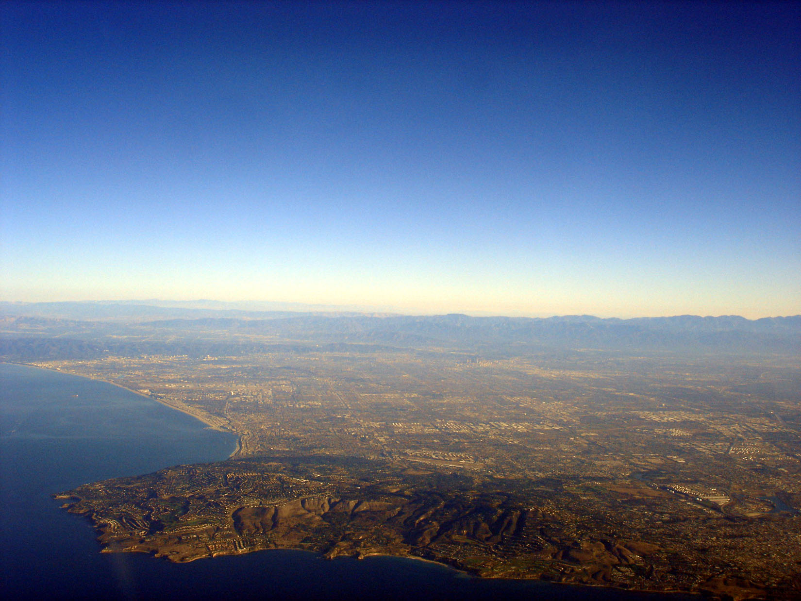
The Los Angeles Basin is a sedimentary Structural basin, basin located in Southern California, in a region known as the Peninsular Ranges. The basin is also connected to an wikt:anomalous, anomalous group of east-west trending chains of mountains collectively known as the Transverse Ranges. The present basin is a coastal lowland area, whose floor is marked by elongate low ridges and groups of hills that is located on the edge of the Pacific Plate. The Los Angeles Basin, along with the Santa Barbara Channel, the Oxnard Plain, Ventura Basin, the San Fernando Valley, and the San Gabriel Valley, San Gabriel Basin, lies within the greater southern California region. On the north, northeast, and east, the lowland Drainage basin, basin is bound by the Santa Monica Mountains and Puente, Elysian, and Repetto hills. To the southeast, the basin is bordered by the Santa Ana Mountains and the San Joaquin Hills. The western boundary of the basin is marked by the Continental Borderland and is ... [...More Info...] [...Related Items...] OR: [Wikipedia] [Google] [Baidu] |
Mount Wilson Observatory
The Mount Wilson Observatory (MWO) is an astronomical observatory in Los Angeles County, California, United States. The MWO is located on Mount Wilson, a peak in the San Gabriel Mountains near Pasadena, northeast of Los Angeles. The observatory contains two historically important telescopes: the Hooker telescope, which was the largest aperture telescope in the world from its completion in 1917 to 1949, and the 60-inch telescope which was the largest operational telescope in the world when it was completed in 1908. It also contains the Snow solar telescope completed in 1905, the 60 foot (18 m) solar tower completed in 1908, the 150 foot (46 m) solar tower completed in 1912, and the CHARA array, built by Georgia State University, which became fully operational in 2004 and was the largest optical interferometer in the world at its completion. Due to the inversion layer that traps warm air and smog over Los Angeles, Mount Wilson has steadier air than any other location in Nor ... [...More Info...] [...Related Items...] OR: [Wikipedia] [Google] [Baidu] |
Mount Wilson (California)
Mount Wilson is a peak in the San Gabriel Mountains, located within the San Gabriel Mountains National Monument and Angeles National Forest in Los Angeles County, California. With only minor topographical prominence the peak is not naturally noticeable from a distance, although it is easily identifiable due to the large number of antennas near its summit. It is a subsidiary peak of nearby San Gabriel Peak. It is the location of the Mount Wilson Observatory, which is an important astronomical facility in Southern California with historic and telescopes, and and solar towers. The newer CHARA Array, run by Georgia State University, is also sited there and does important interferometric stellar research. The summit is at . While not the tallest peak in its vicinity, it is high enough in elevation that snow can sometimes interrupt astronomical activities on the mountain. All of the mountains south of the summit are far shorter leading to unobstructed views across the Los An ... [...More Info...] [...Related Items...] OR: [Wikipedia] [Google] [Baidu] |
Mountain High
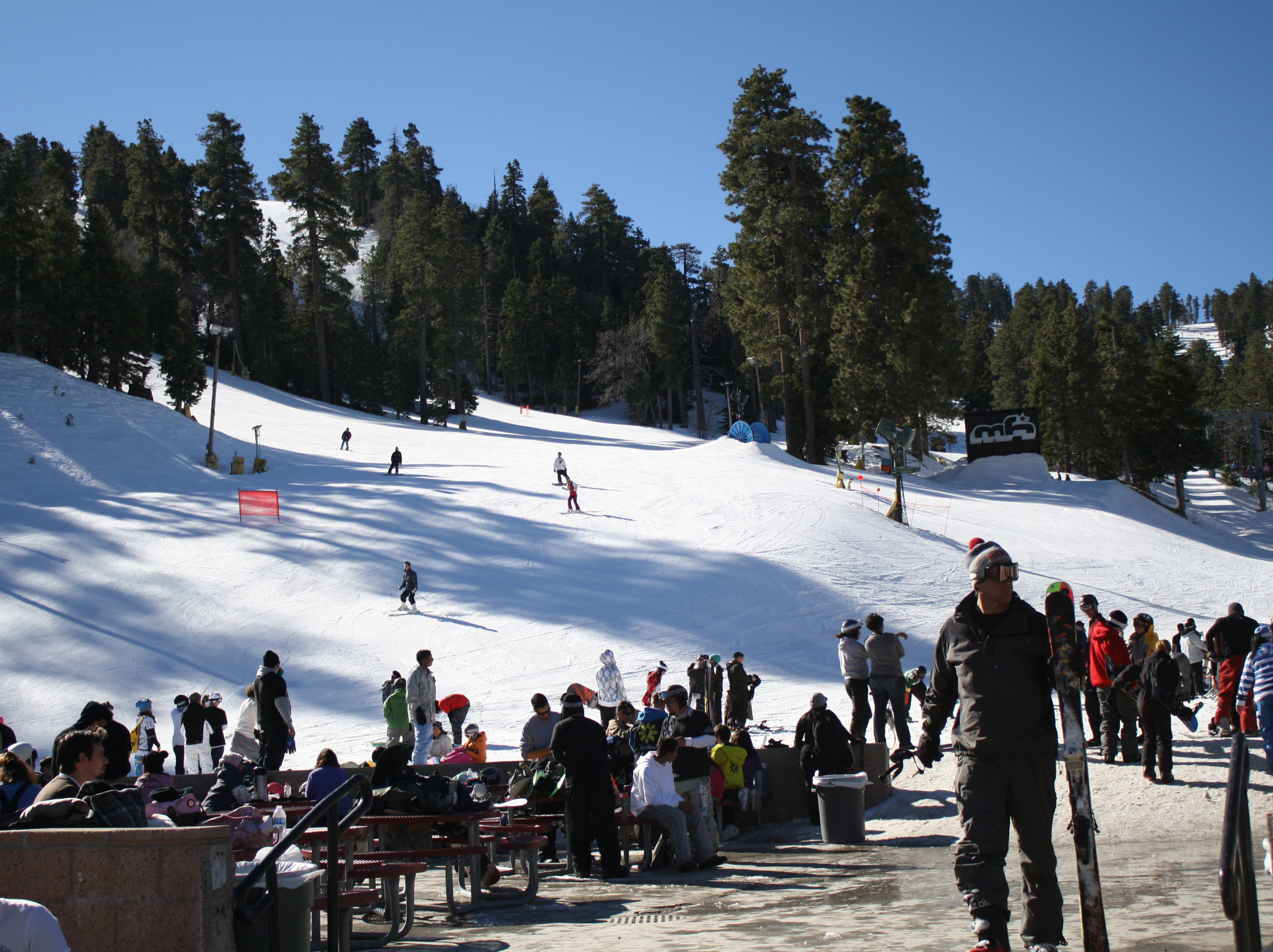
Mountain High resort is a winter resort in the San Gabriel Mountains in Los Angeles County in California. Mountain High is one of the most-visited resorts in Southern California. The resort is located along State Route 2 west of Wrightwood, California. The elevation of the resort is to for the Mountain High East Resort, to for the West Resort and to for the North Resort. History Coinciding with the population growth of Southern California in the 1920s, hikers and ski enthusiasts began using Big Pines, an area near the present day Mountain High resort. In 1929 the construction began on the world's largest ski jump of that time in an attempt to attract the 1932 Winter Olympics. The Mountain High West Resort was originally known as Blue Ridge and is one of the oldest ski resorts in the country. Its first year of operation was 1937 with a rope tow, and it built the 2nd chairlift in California in 1947. In 1975, upon being sold by its original owners, it was renamed Mountain Hi ... [...More Info...] [...Related Items...] OR: [Wikipedia] [Google] [Baidu] |
Visitor Center
A visitor center or centre (see American and British English spelling differences), visitor information center, tourist information center, is a physical location that provides tourist information to visitors. Types of visitor center A visitor center may be: * A visitor center at a specific attraction or place of interest, such as a landmark, national park, national forest, or state park, providing information (such as trail maps, and about camp sites, staff contact, restrooms, etc.) and in-depth educational exhibits and artifact displays (for example, about natural or cultural history). Often a film or other media display is used. If the site has permit requirements or guided tours, the visitor center is often the place where these are coordinated. * A tourist information center, providing visitors to a location with information on the area's attractions, lodgings, maps, and other items relevant to tourism. Often, these centers are operated at the airport or other por ... [...More Info...] [...Related Items...] OR: [Wikipedia] [Google] [Baidu] |
Campground
A campsite, also known as a campground or camping pitch, is a place used for overnight stay in an outdoor area. In British English, a ''campsite'' is an area, usually divided into a number of pitches, where people can camp overnight using tents, campervans or caravans; this British English use of the word is synonymous with the US English expression ''campground''. In American English, the term ''campsite'' generally means an area where an individual, family, group, or military unit can pitch a tent or park a camper; a campground may contain many campsites. There are two types of campsites: an impromptu area (as one might decide to stop while backpacking or hiking, or simply adjacent to a road through the wilderness), and a designated area with various facilities. Campgrounds The term ''camp'' comes from the Latin word ''campus'', meaning "field". Therefore, a campground consists typically of open pieces of ground where a camper can pitch a tent or park a camper. Mo ... [...More Info...] [...Related Items...] OR: [Wikipedia] [Google] [Baidu] |
Newcomb's Ranch
Newcomb's Ranch is a roadhouse at in elevation in the Angeles National Forest, near Los Angeles, California. It is the only private property along the Angeles Crest Highway and is very popular with motorcyclists and is called "the informal headquarters for riders" by the Los Angeles Magazine and "one of Southern California's most famous Rickey Racer Roadhouses" by ''Motorcyclist''. The roadhouse is located in unincorporated Los Angeles County, near La Cañada Flintridge. The Newcomb family, who also created the Mount Waterman ski area, settled the property using the Land Revision Act of 1891, building the roadhouse in 1939. The roadhouse has served as a restaurant, hotel, general store, gas station, and as a brothel or love hotel. The inn burned in 1976, allegedly started by a cook who had been terminated. The fire destroyed most of the second floor, which was not rebuilt. It was purchased in late 2001 by Frederick Rundall, an oncologist who purchased the roadhouse from Lynn ... [...More Info...] [...Related Items...] OR: [Wikipedia] [Google] [Baidu] |
LA Cloudbasin
LA most frequently refers to Los Angeles, the second largest city in the United States. La, LA, or L.A. may also refer to: Arts and entertainment Music * La (musical note), or A, the sixth note * "L.A.", a song by Elliott Smith on ''Figure 8'' (album) * ''L.A.'' (EP), by Teddy Thompson * ''L.A. (Light Album)'', a Beach Boys album * "L.A." (Neil Young song), 1973 * The La's, an English rock band * L.A. Reid, a prominent music producer * Yung L.A., a rapper * Lady A, an American country music trio * "L.A." (Amy Macdonald song), 2007 * "La", a song by Australian-Israeli singer-songwriter Old Man River Other media * l(a, a poem by E. E. Cummings * La (Tarzan), fictional queen of the lost city of Opar (Tarzan) * ''Lá'', later known as Lá Nua, an Irish language newspaper * La7, an Italian television channel * LucasArts, an American video game developer and publisher * Liber Annuus, academic journal Business, organizations, and government agencies * L.A. Screenings, a te ... [...More Info...] [...Related Items...] OR: [Wikipedia] [Google] [Baidu] |


