|
Akrotiri Bay
Akrotiri Bay ( el, Κόλπος Ακρωτηρίου, ''Kolpos Akrotiriou''; tr, Limasol Körfezi) is a part of the Mediterranean Sea east of the Akrotiri Peninsula on the southern coast of the island of Cyprus. The Western Sovereign Base Area of Akrotiri and Dhekelia, a British Overseas Territory set up after Cypriot independence was gained and was unanimously agreed with the British Empire that sovereign bases could be set up for use in the event of an invasion, administered as a Sovereign Base Area, borders the bay. The city of Limassol Limassol (; el, Λεμεσός, Lemesós ; tr, Limasol or ) is a city on the southern coast of Cyprus and capital of the district with the same name. Limassol is the second largest urban area in Cyprus after Nicosia, with an urban population ... is also located on the bay. The southern end of the bay is formed by Cape Gata. Geography of Akrotiri and Dhekelia Bays of Cyprus Ports and harbours of British Overseas Territories [...More Info...] [...Related Items...] OR: [Wikipedia] [Google] [Baidu] |
Mediterranean Sea
The Mediterranean Sea is a sea connected to the Atlantic Ocean, surrounded by the Mediterranean Basin and almost completely enclosed by land: on the north by Western and Southern Europe and Anatolia, on the south by North Africa, and on the east by the Levant. The Sea has played a central role in the history of Western civilization. Geological evidence indicates that around 5.9 million years ago, the Mediterranean was cut off from the Atlantic and was partly or completely desiccated over a period of some 600,000 years during the Messinian salinity crisis before being refilled by the Zanclean flood about 5.3 million years ago. The Mediterranean Sea covers an area of about , representing 0.7% of the global ocean surface, but its connection to the Atlantic via the Strait of Gibraltar—the narrow strait that connects the Atlantic Ocean to the Mediterranean Sea and separates the Iberian Peninsula in Europe from Morocco in Africa—is only wide. The Mediterranean Sea e ... [...More Info...] [...Related Items...] OR: [Wikipedia] [Google] [Baidu] |
Akrotiri Peninsula (Cyprus)
The Akrotiri Peninsula is a short peninsula which includes the southernmost point of the island of Cyprus. It is bounded by Episkopi Bay to the west and Akrotiri Bay to the east and has two capes to the south-west and south-east, known as Cape Zevgari and Cape Gata. The most prominent features of the peninsula are the Akrotiri Salt Lake and the aerodrome, which is RAF Akrotiri and Limassol BBC Relay. In December 2018, a Byzantine church with mosaics including inscriptions in perfect condition dating back to the reign of Emperor Heraclius was discovered during the twelfth excavation season by the Department of Antiquities of Cyprusat the site of Katalymata ton Plakoton, according to an Athens Macedonia News Agency. The Greek Christian inscription described a text “''My Lord help those who honor your name''”. Environment The peninsula, including a variety of wetlands, coastal scrub, dunes and the Episkopi cliffs, has been recognised as an Important Bird Area (IBA) by BirdLife I ... [...More Info...] [...Related Items...] OR: [Wikipedia] [Google] [Baidu] |
Cyprus
Cyprus ; tr, Kıbrıs (), officially the Republic of Cyprus,, , lit: Republic of Cyprus is an island country located south of the Anatolian Peninsula in the eastern Mediterranean Sea. Its continental position is disputed; while it is geographically in Western Asia, its cultural ties and geopolitics are overwhelmingly Southern European. Cyprus is the third-largest and third-most populous island in the Mediterranean. It is located north of Egypt, east of Greece, south of Turkey, and west of Lebanon and Syria. Its capital and largest city is Nicosia. The northeast portion of the island is ''de facto'' governed by the self-declared Turkish Republic of Northern Cyprus, which was established after the 1974 invasion and which is recognised as a country only by Turkey. The earliest known human activity on the island dates to around the 10th millennium BC. Archaeological remains include the well-preserved ruins from the Hellenistic period such as Salamis and Kourion, and Cypr ... [...More Info...] [...Related Items...] OR: [Wikipedia] [Google] [Baidu] |
Western Sovereign Base Area
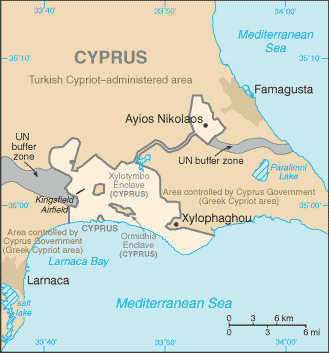
Akrotiri and Dhekelia, officially the Sovereign Base Areas of Akrotiri and Dhekelia (SBA),, ''Periochés Kyríarchon Váseon Akrotiríou ke Dekélias''; tr, Ağrotur ve Dikelya İngiliz Egemen Üs Bölgeleri is a British Overseas Territory on the island of Cyprus. The areas, which include British military bases and installations, as well as other land, were retained by the British under the 1960 treaty of independence, signed by the United Kingdom, Greece, Turkey and representatives from the Greek and Turkish Cypriot communities, which granted independence to the (then) Crown colony of Cyprus. The territory serves an important role as a station for signals intelligence and provides a vital strategic part of the United Kingdom surveillance-gathering network in the Mediterranean and the Middle East. History The Sovereign Base Areas were created in 1960 by the London and Zürich Agreements, when Cyprus achieved independence from the British Empire, as recorded by the Uni ... [...More Info...] [...Related Items...] OR: [Wikipedia] [Google] [Baidu] |
Akrotiri And Dhekelia
Akrotiri and Dhekelia, officially the Sovereign Base Areas of Akrotiri and Dhekelia (SBA),, ''Periochés Kyríarchon Váseon Akrotiríou ke Dekélias''; tr, Ağrotur ve Dikelya İngiliz Egemen Üs Bölgeleri is a British Overseas Territory on the island of Cyprus. The areas, which include British military bases and installations, as well as other land, were retained by the British under the 1960 treaty of independence, signed by the United Kingdom, Greece, Turkey and representatives from the Greek and Turkish Cypriot communities, which granted independence to the (then) Crown colony of Cyprus. The territory serves an important role as a station for signals intelligence and provides a vital strategic part of the United Kingdom surveillance-gathering network in the Mediterranean and the Middle East. History The Sovereign Base Areas were created in 1960 by the London and Zürich Agreements, when Cyprus achieved independence from the British Empire, as recorded by the Unite ... [...More Info...] [...Related Items...] OR: [Wikipedia] [Google] [Baidu] |
British Overseas Territory
The British Overseas Territories (BOTs), also known as the United Kingdom Overseas Territories (UKOTs), are fourteen dependent territory, territories with a constitutional and historical link with the United Kingdom. They are the last remnants of the former British Empire and do not form part of the United Kingdom itself. The permanently inhabited territories are internally Self-governance, self-governing, with the United Kingdom retaining responsibility for Defence (military), defence and foreign relations. Three of the territories are inhabited only by a transitory population of military or scientific personnel. All but one of the rest are listed by the Special Committee on Decolonization, UN Special Committee on Decolonization as United Nations list of non-self-governing territories, non-self-governing territories. All fourteen have the Monarchy of the United Kingdom, British monarch as head of state. three territories (the Falkland Islands, Gibraltar and the Akrotiri an ... [...More Info...] [...Related Items...] OR: [Wikipedia] [Google] [Baidu] |
Sovereign Base Area
Akrotiri and Dhekelia, officially the Sovereign Base Areas of Akrotiri and Dhekelia (SBA),, ''Periochés Kyríarchon Váseon Akrotiríou ke Dekélias''; tr, Ağrotur ve Dikelya İngiliz Egemen Üs Bölgeleri is a British Overseas Territory on the island of Cyprus. The areas, which include British military bases and installations, as well as other land, were retained by the British under the 1960 treaty of independence, signed by the United Kingdom, Greece, Turkey and representatives from the Greek and Turkish Cypriot communities, which granted independence to the (then) Crown colony of Cyprus. The territory serves an important role as a station for signals intelligence and provides a vital strategic part of the United Kingdom surveillance-gathering network in the Mediterranean and the Middle East. History The Sovereign Base Areas were created in 1960 by the London and Zürich Agreements, when Cyprus achieved independence from the British Empire, as recorded by the Unite ... [...More Info...] [...Related Items...] OR: [Wikipedia] [Google] [Baidu] |
Limassol
Limassol (; el, Λεμεσός, Lemesós ; tr, Limasol or ) is a city on the southern coast of Cyprus and capital of the district with the same name. Limassol is the second largest urban area in Cyprus after Nicosia, with an urban population of 183,658 and a metropolitan population of 239,842. In 2014, Limassol was ranked by TripAdvisor as the 3rd up-and-coming destination in the world, in its Top 10 Traveler's Choice Destinations on the Rise list. The city is also ranked 89th worldwide in Mercer's Quality of Living Survey (2017). In the 2020 ranking published by the Globalization and World Cities Research Network, Limassol was classified as a "Gamma −" global city. History Limassol was built between two ancient Greek cities, Amathus and Kourion, and during Byzantine rule it was known as Neapolis (new town). Limassol's historical centre is located around its medieval Limassol Castle and the Old Port. Today the city spreads along the Mediterranean coast and has extende ... [...More Info...] [...Related Items...] OR: [Wikipedia] [Google] [Baidu] |
Cape Gata
{{Cyprus-geo-stub ...
Cape Gata ( "cat cape", "falcon cape") is the south-eastern cape of the Akrotiri Peninsula on the Mediterranean island of Cyprus. It is located within the British Sovereign Base Areas, and is the southernmost point of the island. However, the Sovereign Base Areas are not part of the Republic of Cyprus or the European Union, whose southernmost point lies nearby at the border between the two (34° 39’ N). Gata Davionte Ganter, known professionally as GaTa, is an American rapper and actor known for his role in the FXX TV series ''Dave'', as well as for being the hype man for rapper Lil Dicky throughout his career as well as on the show. Early life an ... [...More Info...] [...Related Items...] OR: [Wikipedia] [Google] [Baidu] |
10PortSqn
1 (one, unit, unity) is a number representing a single or the only entity. 1 is also a numerical digit and represents a single unit of counting or measurement. For example, a line segment of ''unit length'' is a line segment of length 1. In conventions of sign where zero is considered neither positive nor negative, 1 is the first and smallest positive integer. It is also sometimes considered the first of the infinite sequence of natural numbers, followed by 2, although by other definitions 1 is the second natural number, following 0. The fundamental mathematical property of 1 is to be a multiplicative identity, meaning that any number multiplied by 1 equals the same number. Most if not all properties of 1 can be deduced from this. In advanced mathematics, a multiplicative identity is often denoted 1, even if it is not a number. 1 is by convention not considered a prime number; this was not universally accepted until the mid-20th century. Additionally, 1 is ... [...More Info...] [...Related Items...] OR: [Wikipedia] [Google] [Baidu] |
Geography Of Akrotiri And Dhekelia
Akrotiri and Dhekelia, officially the Sovereign Base Areas of Akrotiri and Dhekelia (SBA),, ''Periochés Kyríarchon Váseon Akrotiríou ke Dekélias''; tr, Ağrotur ve Dikelya İngiliz Egemen Üs Bölgeleri is a British Overseas Territory on the island of Cyprus. The areas, which include British military bases and installations, as well as other land, were retained by the British under the 1960 treaty of independence, signed by the United Kingdom, Greece, Turkey and representatives from the Greek and Turkish Cypriot communities, which granted independence to the (then) Crown colony of Cyprus. The territory serves an important role as a station for signals intelligence and provides a vital strategic part of the United Kingdom surveillance-gathering network in the Mediterranean and the Middle East. History The Sovereign Base Areas were created in 1960 by the London and Zürich Agreements, when Cyprus achieved independence from the British Empire, as recorded by the Uni ... [...More Info...] [...Related Items...] OR: [Wikipedia] [Google] [Baidu] |


