|
Addi Azmera
Addi Azmera is a ''tabia'' or municipality in the Dogu'a Tembien district of the Tigray Region of Ethiopia. The name refers to good spring rains (“azmera”), in relation to the local microclimate. The ''tabia'' centre is in Tukhul town, located approximately half-way between the ''woreda'' town Hagere Selam and the regional capital Mekelle. Geography The ''tabia'' stretches on both sides of the main road that climbs towards Dogu’a Tembien after passing the bridge on Giba River. The highest location are the upper slopes of Imba Dogu’a (2590 m a.s.l.) and the lowest place along Giba River (1750 m a.s.l.). It comprises cultivated plains and steeper slopes, with often good vegetation (re)growth. Geology From the higher to the lower locations, the following geological formations are present: * Mekelle Dolerite * Amba Aradam Formation * Agula Shale - there are gypsum quarries in this formation, exploited by the cement factory of Mekelle * Antalo Limestone – many quarri ... [...More Info...] [...Related Items...] OR: [Wikipedia] [Google] [Baidu] |
Exclosure
An exclosure, in an area being used extensively for grazing, is a limited area from which unwanted browsing animals, such as domestic cattle or wildlife such as deer, are excluded by fencing or other means. Environmental protection Most commonly, exclosures are areas that are set aside for regreening. Wood harvesting and livestock range are not allowed there. Effects on environment The establishment of an exclosure has positive effects on: * biodiversity * water infiltration * protection from flooding * sediment deposition * carbon sequestration Economic benefits In developing countries, people commonly have economic benefits from these exclosures through grass harvesting, beekeeping and other non-timber forest products. The local inhabitants also consider it as “land set aside for future generations”. Carbon credits Exclosures have as an additional benefit that the surrounding communities may receive carbon credits for the sequestered CO2, as part of a carbon offs ... [...More Info...] [...Related Items...] OR: [Wikipedia] [Google] [Baidu] |
Clay
Clay is a type of fine-grained natural soil material containing clay minerals (hydrous aluminium phyllosilicates, e.g. kaolin, Al2 Si2 O5( OH)4). Clays develop plasticity when wet, due to a molecular film of water surrounding the clay particles, but become hard, brittle and non–plastic upon drying or firing. Most pure clay minerals are white or light-coloured, but natural clays show a variety of colours from impurities, such as a reddish or brownish colour from small amounts of iron oxide. Clay is the oldest known ceramic material. Prehistoric humans discovered the useful properties of clay and used it for making pottery. Some of the earliest pottery shards have been dated to around 14,000 BC, and clay tablets were the first known writing medium. Clay is used in many modern industrial processes, such as paper making, cement production, and chemical filtering. Between one-half and two-thirds of the world's population live or work in buildings made with clay, often ... [...More Info...] [...Related Items...] OR: [Wikipedia] [Google] [Baidu] |
Groundwater Recharge
Groundwater recharge or deep drainage or deep percolation is a hydrologic process, where water moves downward from surface water to groundwater. Recharge is the primary method through which water enters an aquifer. This process usually occurs in the vadose zone below plant roots and is often expressed as a flux to the water table surface. Groundwater recharge also encompasses water moving away from the water table farther into the saturated zone. Recharge occurs both naturally (through the water cycle) and through anthropogenic processes (i.e., "artificial groundwater recharge"), where rainwater and or reclaimed water is routed to the subsurface. Processes Water is recharged naturally by rain and snow melt and to a smaller extent by surface water (rivers and lakes). Recharge may be impeded somewhat by human activities including paving, development, or logging. These activities can result in loss of topsoil resulting in reduced water infiltration, enhanced surface runoff and ... [...More Info...] [...Related Items...] OR: [Wikipedia] [Google] [Baidu] |
Seepage
Soil mechanics is a branch of soil physics and applied mechanics that describes the behavior of soils. It differs from fluid mechanics and solid mechanics in the sense that soils consist of a heterogeneous mixture of fluids (usually air and water) and particles (usually clay, silt, sand, and gravel) but soil may also contain organic solids and other matter.Mitchell, J.K., and Soga, K. (2005) Fundamentals of soil behavior, Third edition, John Wiley and Sons, Inc., .Powrie, W., Spon Press, 2004, ''Soil Mechanics – 2nd ed'' A Guide to Soil Mechanics, Bolton, Malcolm, Macmillan Press, 1979. Along with rock mechanics, soil mechanics provides the theoretical basis for analysis in geotechnical engineering, a subdiscipline of civil engineering, and engineering geology, a subdiscipline of geology. Soil mechanics is used to analyze the deformations of and flow of fluids within natural and man-made structures that are supported on or made of soil, or structures that are buried in soils.L ... [...More Info...] [...Related Items...] OR: [Wikipedia] [Google] [Baidu] |
Lake Giba
Lake Giba is a reservoir under construction at the border of the Inderta; Kilte Awula'ilo and Dogu’a Tembien ''woredas'' of the Tigray Region in Ethiopia. The earthen dam that holds the reservoir is under construction in 2020. It will collect the water from the catchments of Sulluh River (969 km²), Genfel River (733 km²) and Agula'i River (692 km²). Dam characteristics The dam is aimed to provide drinking water to Mekelle and to regulate the river flow. * Dam height: 80 metres * Dam crest length: 1000 metres Capacity * Original capacity: 350 million m³ * Reservoir area: 9 km³ Average annual sediment input to the reservoir by the main rivers was calculated as 3.8 million tonnes: * Sulluh: 862,410 t * Genfel: 364,301 t * Agula'i River: 2,618,528 t Flooding The dam will occupy the wide valley bottom at the river confluences, which is currently occupied by farmlands and bushlands. The reservoir will extend into the lower Genfel and Suluh gorge ... [...More Info...] [...Related Items...] OR: [Wikipedia] [Google] [Baidu] |
Sorghum
''Sorghum'' () is a genus of about 25 species of flowering plants in the grass family (Poaceae). Some of these species are grown as cereals for human consumption and some in pastures for animals. One species is grown for grain, while many others are used as fodder plants, either cultivated in warm climates worldwide or naturalized in pasture lands. Taxonomy ''Sorghum'' is in the Poaceae (grass) subfamily Panicoideae and the tribe Andropogoneae (the same as maize, big bluestem and sugarcane). Species Accepted species recorded include: Distribution and habitat Seventeen of the 25 species are native to Australia, with the range of some extending to Africa, Asia, Mesoamerica, and certain islands in the Indian and Pacific Oceans. Toxicity In the early stages of the plants' growth, some species of sorghum can contain levels of hydrogen cyanide, hordenine, and nitrates, which are lethal to grazing animals. Plants stressed by drought or heat can also contain toxic lev ... [...More Info...] [...Related Items...] OR: [Wikipedia] [Google] [Baidu] |
Orographic Rain
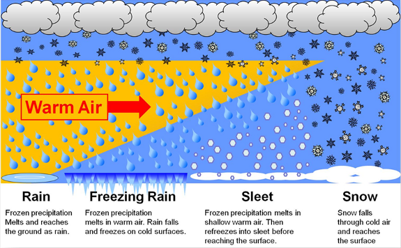
In meteorology, the different types of precipitation often include the character, formation, or phase of the precipitation which is falling to ground level. There are three distinct ways that precipitation can occur. Convective precipitation is generally more intense, and of shorter duration, than stratiform precipitation. Orographic precipitation occurs when moist air is forced upwards over rising terrain and condenses on the slope, such as a mountain. Precipitation can fall in either liquid or solid phases, is mixed with both, or transition between them at the freezing level. Liquid forms of precipitation include rain and drizzle and dew. Rain or drizzle which freezes on contact with a surface within a subfreezing air mass gains the preceding adjective "freezing", becoming the known freezing rain or freezing drizzle. Slush is a mixture of both liquid and solid precipitation. Frozen forms of precipitation include snow, ice crystals, ice pellets (sleet), hail, and graupel. Their r ... [...More Info...] [...Related Items...] OR: [Wikipedia] [Google] [Baidu] |
Sorghum In Addi Azmera
''Sorghum'' () is a genus of about 25 species of flowering plants in the grass family ( Poaceae). Some of these species are grown as cereals for human consumption and some in pastures for animals. One species is grown for grain, while many others are used as fodder plants, either cultivated in warm climates worldwide or naturalized in pasture lands. Taxonomy ''Sorghum'' is in the Poaceae (grass) subfamily Panicoideae and the tribe Andropogoneae (the same as maize, big bluestem and sugarcane). Species Accepted species recorded include: Distribution and habitat Seventeen of the 25 species are native to Australia, with the range of some extending to Africa, Asia, Mesoamerica, and certain islands in the Indian and Pacific Oceans The Pacific Ocean is the largest and deepest of Earth's five oceanic divisions. It extends from the Arctic Ocean in the north to the Southern Ocean (or, depending on definition, to Antarctica) in the south, and is bounded by the ... [...More Info...] [...Related Items...] OR: [Wikipedia] [Google] [Baidu] |
Vertisol
A vertisol, or vertosol, is a soil type in which there is a high content of expansive clay minerals, many of them known as montmorillonite, that form deep cracks in drier seasons or years. In a phenomenon known as argillipedoturbation, alternate shrinking and swelling causes ''self-ploughing'', where the soil material consistently mixes itself, causing some vertisols to have an extremely deep A horizon and no B horizon. (A soil with no B horizon is called an ''A/C soil''). This heaving of the underlying material to the surface often creates a microrelief known as ''gilgai''. Vertisols typically form from highly basic rocks, such as basalt, in climates that are seasonally humid or subject to erratic droughts and floods, or that impeded drainage. Depending on the parent material and the climate, they can range from grey or red to the more familiar deep black (known as "black earths" in Australia, "black gumbo" in East Texas, "black cotton" soils in East Africa, and "vlei soils" ... [...More Info...] [...Related Items...] OR: [Wikipedia] [Google] [Baidu] |
Luvisol
Luvisols are a group of soils, comprising one of the 32 Reference Soil Groups in the international system of soil classification, the World Reference Base for Soil Resources The World Reference Base for Soil Resources (WRB) is an international soil classification system for naming soils and creating legends for soil maps. The currently valid version is the fourth edition 2022. It is edited by a working group of the Inte ... (WRB). They are widespread, especially in temperate climates, and are generally fertile. Luvisols are widely used for agriculture. Distribution Luvisols cover 500–600 million ha of land area, mainly in the temperate zones. They form on a wide variety of mineral parent materials. In Mediterranean regions, the formation of hematite can produce red-coloured Chromic Luvisols. Description and formation The main characteristic of Luvisols is an argic horizon, a subsurface zone with higher clay content than the material above it. This typically arises as clay is was ... [...More Info...] [...Related Items...] OR: [Wikipedia] [Google] [Baidu] |


