|
Acharn, Perth And Kinross
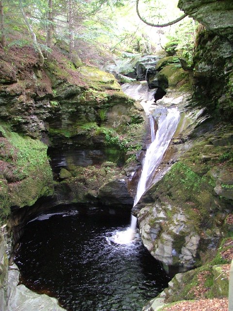
Acharn (Scottish Gaelic: meaning 'Field of the Cairn ) is a hamlet in the Kenmore parish of the Scottish council area of Perth and Kinross. It is situated on the south shore of Loch Tay close to its eastern end. The hamlet was built in the early 19th century to house workers from the surrounding estates. A watermill was constructed to harness the power of the nearby Acharn Burn, and this was converted into a craft centre in the 1970s, and later into a private residence. There is a bridge in the middle that goes over the Acharn burn. The Falls of Acharn, a series of waterfalls with a total height of set in a steep wooded gorge, are a popular tourist attraction on the nearby Acharn Burn south of the hamlet. The steep Acharn Falls Walk is about straight up and down from the village, and is a dangerous place to walk dogs without leads, but provides scenic views of the falls above the village. The upper falls have a timber walkway constructed by the 202 Field Squadron RE (V) i ... [...More Info...] [...Related Items...] OR: [Wikipedia] [Google] [Baidu] |
Perth And Kinross
Perth and Kinross ( sco, Pairth an Kinross; gd, Peairt agus Ceann Rois) is one of the 32 council areas of Scotland and a Lieutenancy Area. It borders onto the Aberdeenshire, Angus, Argyll and Bute, Clackmannanshire, Dundee, Fife, Highland and Stirling council areas. Perth is the administrative centre. With the exception of a large area of south-western Perthshire, the council area mostly corresponds to the historic counties of Perthshire and Kinross-shire. Perthshire and Kinross-shire shared a joint county council from 1929 until 1975. The area formed a single local government district in 1975 within the Tayside region under the ''Local Government (Scotland) Act 1973'', and was then reconstituted as a unitary authority (with a minor boundary adjustment) in 1996 by the ''Local Government etc. (Scotland) Act 1994''. Geographically the area is split by the Highland Boundary Fault into a more mountainous northern part and a flatter southern part. The northern area is a popular to ... [...More Info...] [...Related Items...] OR: [Wikipedia] [Google] [Baidu] |
Watermill
A watermill or water mill is a mill that uses hydropower. It is a structure that uses a water wheel or water turbine to drive a mechanical process such as milling (grinding), rolling, or hammering. Such processes are needed in the production of many material goods, including flour, lumber, paper, textiles, and many metal products. These watermills may comprise gristmills, sawmills, paper mills, textile mills, hammermills, trip hammering mills, rolling mills, wire drawing mills. One major way to classify watermills is by wheel orientation (vertical or horizontal), one powered by a vertical waterwheel through a gear mechanism, and the other equipped with a horizontal waterwheel without such a mechanism. The former type can be further divided, depending on where the water hits the wheel paddles, into undershot, overshot, breastshot and pitchback (backshot or reverse shot) waterwheel mills. Another way to classify water mills is by an essential trait about their location: tide mills ... [...More Info...] [...Related Items...] OR: [Wikipedia] [Google] [Baidu] |
Crannog
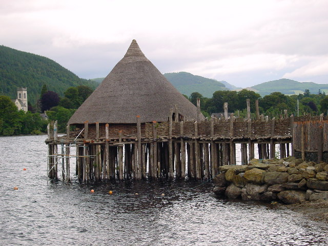
A crannog (; ga, crannóg ; gd, crannag ) is typically a partially or entirely artificial island, usually built in lakes and estuarine waters of Scotland, Wales, and Ireland. Unlike the prehistoric pile dwellings around the Alps, which were built on the shores and not inundated until later, crannogs were built in the water, thus forming artificial islands. Crannogs were used as dwellings over five millennia, from the European Neolithic Period to as late as the 17th/early 18th century. In Scotland there is no convincing evidence in the archaeological record of Early and Middle Bronze Age or Norse Period use. The radiocarbon dating obtained from key sites such as Oakbank and Redcastle indicates at a 95.4 per cent confidence level that they date to the Late Bronze Age to Early Iron Age. The date ranges fall ''after'' around 800 BC and so could be considered Late Bronze Age by only the narrowest of margins. Crannogs have been variously interpreted as free-standing wooden struct ... [...More Info...] [...Related Items...] OR: [Wikipedia] [Google] [Baidu] |
Open-air Museum
An open-air museum (or open air museum) is a museum that exhibits collections of buildings and artifacts out-of-doors. It is also frequently known as a museum of buildings or a folk museum. Definition Open air is “the unconfined atmosphere…outside buildings...” In the loosest sense, an open-air museum is any institution that includes one or more buildings in its collections, including farm museums, historic house museums, and archaeological open-air museums. Mostly, 'open-air museum is applied to a museum that specializes in the collection and re-erection of multiple old buildings at large outdoor sites, usually in settings of recreated landscapes of the past, and often include living history. They may, therefore, be described as building museums. European open-air museums tended to be sited originally in regions where wooden architecture prevailed, as wooden structures may be translocated without substantial loss of authenticity. Common to all open-air museums, including ... [...More Info...] [...Related Items...] OR: [Wikipedia] [Google] [Baidu] |
Scottish Crannog Centre
Kenmore ( gd, A' Cheannmhor, IPA: �aˈçaun̴̪auvɔɾ is a small village in Perthshire, in the Highlands of Scotland, located where Loch Tay drains into the River Tay. History The village dates from the 16th century. It and the neighbouring Castle were originally known as Balloch (from Gaelic ''bealach'', 'pass'). The original village was sited on the north side of river approximately from its present site and was known as Inchadney. In 1540 Sir Colin Campbell of Glenorchy started the construction of Balloch castle on the opposite bank of the river and the entire village was moved to a prominent headland by the shores of Loch Tay, hence the name Kenmore, which translates from Scots Gaelic to "big (or large) head". The village as it is seen today is a model village laid out by 3rd Earl of Breadalbane in 1760. Landmarks and tourism The Kenmore Hotel, commissioned in 1572 by the then laird Colin Campbell, has its origins in a tavern built around 70 years earlier offering accommo ... [...More Info...] [...Related Items...] OR: [Wikipedia] [Google] [Baidu] |
Dorothy Wordsworth
Dorothy Mae Ann Wordsworth (25 December 1771 – 25 January 1855) was an English author, poet, and diarist. She was the sister of the Romantic poet William Wordsworth, and the two were close all their adult lives. Dorothy Wordsworth had no ambitions to be a public author, yet she left behind numerous letters, diary entries, topographical descriptions, poems, and other writings. Life She was born on Christmas Day in Cockermouth, Cumberland, in 1771. Despite the early death of her mother, Dorothy, William and their three brothers had a happy childhood. When in 1783 their father died and the children were sent to live with various relatives, Dorothy was sent alone to live with her aunt, Elizabeth Threlkeld, in Halifax, West Yorkshire. After she was able to be reunited with William, firstly at Racedown Lodge in Dorset in 1795 and afterwards (1797/98) at Alfoxden House in Somerset, they became inseparable companions. The pair lived in poverty at first, and would often beg for ca ... [...More Info...] [...Related Items...] OR: [Wikipedia] [Google] [Baidu] |
William Wordsworth
William Wordsworth (7 April 177023 April 1850) was an English Romantic poet who, with Samuel Taylor Coleridge, helped to launch the Romantic Age in English literature with their joint publication ''Lyrical Ballads'' (1798). Wordsworth's ''magnum opus'' is generally considered to be ''The Prelude'', a semi-autobiographical poem of his early years that he revised and expanded a number of times. It was posthumously titled and published by his wife in the year of his death, before which it was generally known as "the poem to Coleridge". Wordsworth was Poet Laureate from 1843 until his death from pleurisy on 23 April 1850. Early life The second of five children born to John Wordsworth and Ann Cookson, William Wordsworth was born on 7 April 1770 in what is now named Wordsworth House in Cockermouth, Cumberland, (now in Cumbria), part of the scenic region in northwestern England known as the Lake District. William's sister, the poet and diarist Dorothy Wordsworth, to whom he wa ... [...More Info...] [...Related Items...] OR: [Wikipedia] [Google] [Baidu] |
Folly
In architecture, a folly is a building constructed primarily for decoration, but suggesting through its appearance some other purpose, or of such extravagant appearance that it transcends the range of usual garden buildings. Eighteenth-century English landscape gardening and French landscape gardening often featured mock Roman temples, symbolising classical virtues. Other 18th-century garden follies represented Chinese temples, Egyptian pyramids, ruined medieval castles or abbeys, or Tatar tents, to represent different continents or historical eras. Sometimes they represented rustic villages, mills, and cottages to symbolise rural virtues. Many follies, particularly during times of famine, such as the Great Famine (Ireland), Great Famine in Ireland, were built as a form of poor relief, to provide employment for peasants and unemployed artisans. In English, the term began as "a popular name for any costly structure considered to have shown wikt:folly#Noun, folly in the builde ... [...More Info...] [...Related Items...] OR: [Wikipedia] [Google] [Baidu] |
Ordnance Survey
, nativename_a = , nativename_r = , logo = Ordnance Survey 2015 Logo.svg , logo_width = 240px , logo_caption = , seal = , seal_width = , seal_caption = , picture = , picture_width = , picture_caption = , formed = , preceding1 = , dissolved = , superseding = , jurisdiction = Great BritainThe Ordnance Survey deals only with maps of Great Britain, and, to an extent, the Isle of Man, but not Northern Ireland, which has its own, separate government agency, the Ordnance Survey of Northern Ireland. , headquarters = Southampton, England, UK , region_code = GB , coordinates = , employees = 1,244 , budget = , minister1_name = , minister1_pfo = , chief1_name = Steve Blair , chief1_position = CEO , agency_type = , parent_agency = , child1_agency = , keydocument1 = , website = , footnotes = , map = , map_width = , map_caption = Ordnance Survey (OS) is the national mapping agency for Great Britain. The agency's name indicates its original military purpose (se ... [...More Info...] [...Related Items...] OR: [Wikipedia] [Google] [Baidu] |
Perth And North Perthshire (UK Parliament Constituency)
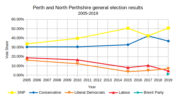
Perth and North Perthshire is a county constituency of the House of Commons of the Parliament of the United Kingdom. It elects one Member of Parliament (MP) by the first past the post system of election. The constituency was created in 2005. Campaigns in the seat have resulted in a minimum of 30% of votes at each election consistently for the same two parties' choice for candidate, and the next lower-placed party's having fluctuated between 8.1% and 18.7% of the vote since its relatively recent creation. The seat attracted a record seven candidates in 2015 and has seen as few as four, in 2017. Boundaries As a result of the Fifth Periodical Review of the Boundary Commission for Scotland, the constituency (seat) was created to cover northern parts of the Perth and Kinross council area, and first used in the 2005 general election. Ochil and South Perthshire was created, at the same time, to cover the rest of that council area and the Clackmannanshire council area. Before ... [...More Info...] [...Related Items...] OR: [Wikipedia] [Google] [Baidu] |
Loch Tay
Loch Tay ( gd, Loch Tatha) is a freshwater loch in the central highlands of Scotland, in the Perth and Kinross and Stirling council areas. It is the largest body of fresh water in Perth and Kinross, and the sixth largest loch in Scotland. The watershed of Loch Tay traditionally formed the historic province of Breadalbane. It is a long, narrow loch of around long, and typically around wide, following the line of the strath from the south west to north east. It is the sixth-largest loch in Scotland by area and over deep at its deepest. Pre-history and archaeology Between 1996 and 2005, a large scale project was carried out to investigate the heritage and archaeology of Loch Tay, the Ben Lawers Historic Landscape (BLHL) Project. It took place primarily on the National Trust for Scotland’s property but included some local landowners who held the agricultural lands between the head-dyke and the loch-shore. Mesolithic period Before 1996 the earliest known evidence for oc ... [...More Info...] [...Related Items...] OR: [Wikipedia] [Google] [Baidu] |
Scotland
Scotland (, ) is a country that is part of the United Kingdom. Covering the northern third of the island of Great Britain, mainland Scotland has a border with England to the southeast and is otherwise surrounded by the Atlantic Ocean to the north and west, the North Sea to the northeast and east, and the Irish Sea to the south. It also contains more than 790 islands, principally in the archipelagos of the Hebrides and the Northern Isles. Most of the population, including the capital Edinburgh, is concentrated in the Central Belt—the plain between the Scottish Highlands and the Southern Uplands—in the Scottish Lowlands. Scotland is divided into 32 administrative subdivisions or local authorities, known as council areas. Glasgow City is the largest council area in terms of population, with Highland being the largest in terms of area. Limited self-governing power, covering matters such as education, social services and roads and transportation, is devolved from the Scott ... [...More Info...] [...Related Items...] OR: [Wikipedia] [Google] [Baidu] |


