|
Aboyne
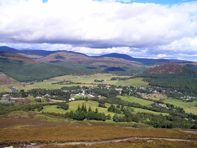
Aboyne ( sco, Abyne, gd, Abèidh) is a village on the edge of the Highlands in Aberdeenshire, Scotland, on the River Dee, approximately west of Aberdeen. It has a swimming pool at Aboyne Academy, all-weather tennis courts, a bowling green and is home to the oldest 18 hole golf course on Royal Deeside. Aboyne Castle and the Loch of Aboyne are nearby. Aboyne has many businesses, including a supermarket (Co-op), one bank, several hairdressers, a butcher, a newsagent, an Indian restaurant and a post office. Originally, there was a railway station in the village, but it was closed on 18 June 1966. The station now contains some shops and the tunnel running under the village is now home to a firearms club. The market-day in Aboyne was known as ''Fèill Mhìcheil'' (Scottish Gaelic for "Michael's Fair"). History The name “Aboyne” is derived from “Oboyne”, first recorded in 1260, in turn derived from the Gaelic words “abh”, “bo”, and “fionn”, meaning “lace bywhi ... [...More Info...] [...Related Items...] OR: [Wikipedia] [Google] [Baidu] |
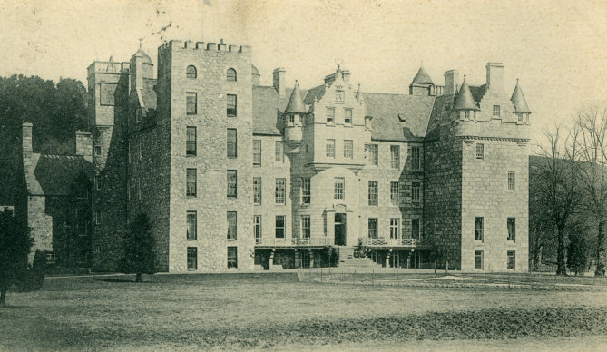
Aboyne Castle
Aboyne Castle (historical name: castrum de Obeyn; alternate names: Castle Of Aboyne or Aboyne Castle Policies; also Bonty Castle or Bunty Castle) is a 13th-century castle in Aberdeenshire, Scotland north of the town of Aboyne (Grid Reference NO5299). The location of Aboyne Castle was selected for its strategic position near the River Dee and controlling the northern end of one of the Mounth crossings.Simpson, W. Douglas. ''The Early Castles of Mar'', Proceedings of the Society: 102, 10 December 1928 Aboyne Castle was formerly derelict, but was restored by the present Marquess of Huntly in 1979. Architecture The castle was constructed by Bysets, Lords of Strathdee and Aboyne before 1233 as a motte-and-bailey. Edward I sent instructions for its fortification in 1307. It was later turned into a stone keep. in 1671, the west wing was rebuilt as a tower house by Charles, first Earl of Aboyne, parts of which are still visible. A mansion house was added in 1701. An east wing was a ... [...More Info...] [...Related Items...] OR: [Wikipedia] [Google] [Baidu] |
Loch Of Aboyne
Loch of Aboyne is a shallow, artificial formed, freshwater loch in Grampian, Scotland. It lies northeast of Aboyne and west-southwest of Aberdeen. An earthen dam was constructed around 1834 to retain the loch. It also served as a reservoir for a nearby mill. Survey The loch was surveyed on 13 July 1905 by T.N. Johnston and L.W. Collett and later charted as part of the Sir John Murray's ''Bathymetrical Survey of Fresh-Water Lochs of Scotland 1897-1909''. Flora and fauna The loch was designated a Site of Special Scientific Interest in 1984 owing to its aquatic flora and fauna and rich reedbed and fen vegetation. It has one of the finest submerged floras in the area with 8 species of pondweeds. There is a high diversity of leeches and pond snails and modest numbers of passage and wintering wildfowl including wigeon, goosander and whooper swans. It provides a valuable habitat for waterfowl and other birds, with Osprey regularly seen plucking fish from the water. It is also an ... [...More Info...] [...Related Items...] OR: [Wikipedia] [Google] [Baidu] |
Aboyne Railway Station
Aboyne railway station was a station which served Aboyne in the Scottish county of Aberdeenshire. It was served by trains on the line from Aberdeen to Ballater. History The Deeside Railway had originally intended to build its railway to Aboyne but it was reincorporated in 1852 with powers only to build as far as . A second company, the Deeside Extension Railway, was incorporated in 1857 to continue the line to Aboyne where it opened the station on 2 December 1859 as its terminus. The line was extended to by a third company, Aboyne and Braemar Railway, which opened on 17 October 1866 when the station ceased to be a terminus. Later to be leased and then part of the Great North of Scotland Railway, the station became part of the London and North Eastern Railway during the Grouping of 1923, passing on to the Scottish Region of British Railways during the nationalisation of 1948. It was then closed by the British Railways Board on 28 February 1966. The station was host to a LNER ... [...More Info...] [...Related Items...] OR: [Wikipedia] [Google] [Baidu] |
Charles Gordon, 1st Earl Of Aboyne
Charles Gordon, 1st Earl of Aboyne (c1638 - March 1681). The fourth son of George Gordon, 2nd Marquess of Huntly and Lady Anne Campbell, he was created 1st Earl of Aboyne and 1st Lord Gordon of Strathaven and Glenlivet by Letters Patent on 10 September 1660. At the time of his death in March 1681, he was succeeded in the earldom and lordship by his son. Family He married firstly, Margaret Irvine, daughter of Alexander Irvine, c1662, and had issue: *Lady Ann Gordon (d. c1665) His first wife died in 1662. He married secondly, Elizabeth Lyon, daughter of John Lyon, 2nd Earl of Kinghorne and Lady Elizabeth Maule, on 28 August 1665, and had issue: * Charles Gordon, 2nd Earl of Aboyne (c1670-1702) *Hon. George Gordon *Hon. John Gordon (d.1762) *Lady Elizabeth Gordon, married John Mackenzie, 2nd Earl of Cromartie John is a common English name and surname: * John (given name) * John (surname) John may also refer to: New Testament Works * Gospel of John, a title often short ... [...More Info...] [...Related Items...] OR: [Wikipedia] [Google] [Baidu] |
Aberdeenshire West (Scottish Parliament Constituency)
Aberdeenshire West (Gaelic: ''Siorrachd Obar Dheathain an Iar'') is a constituency of the Scottish Parliament ( Holyrood) covering part of the council area of Aberdeenshire. It elects one Member of the Scottish Parliament (MSP) by the first past the post method of election. Also, however, it is one of ten constituencies in the North East Scotland electoral region, which elects seven additional members, in addition to ten constituency MSPs, to produce a form of proportional representation for the region as a whole. The seat has been held by Alexander Burnett of the Scottish Conservatives since the 2016 Scottish Parliament election. Electoral region The other nine constituencies of the North East Scotland region are Aberdeen Central, Aberdeen Donside, Aberdeen South and North Kincardine, Aberdeenshire East, Angus North and Mearns, Angus South, Banffshire and Buchan Coast, Dundee City East and Dundee City West. The region covers all of the Aberdeen City council ... [...More Info...] [...Related Items...] OR: [Wikipedia] [Google] [Baidu] |
River Dee, Aberdeenshire
The River Dee ( gd, Uisge Dhè) is a river in Aberdeenshire, Scotland. It rises in the Cairngorms and flows through southern Aberdeenshire to reach the North Sea at Aberdeen. The area it passes through is known as Deeside, or Royal Deeside in the region between Braemar and Banchory because Queen Victoria came for a visit there in 1848 and greatly enjoyed herself. She and her husband, Prince Albert, built Balmoral Castle there which replaced an older castle. Deeside is a popular area for tourists, due to the combination of scenic beauty and historic and royal associations. It is part of the Cairngorms National Park, and the Deeside and Lochnagar National Scenic Area. The Dee is popular with anglers and is one of the most famous salmon fishing rivers in the world. The New Statistical Account of Scotland attributed the name Dee as having been used as early as the second century AD in the work of the Alexandrian geographer Claudius Ptolemy, as ''Δηοῦα'' (=Deva), meaning ... [...More Info...] [...Related Items...] OR: [Wikipedia] [Google] [Baidu] |
Aberdeenshire
Aberdeenshire ( sco, Aiberdeenshire; gd, Siorrachd Obar Dheathain) is one of the 32 Subdivisions of Scotland#council areas of Scotland, council areas of Scotland. It takes its name from the County of Aberdeen which has substantially different boundaries. The Aberdeenshire Council area includes all of the area of the Counties of Scotland, historic counties of Aberdeenshire and Kincardineshire (except the area making up the City of Aberdeen), as well as part of Banffshire. The county boundaries are officially used for a few purposes, namely land registration and Lieutenancy areas of Scotland, lieutenancy. Aberdeenshire Council is headquartered at Woodhill House, in Aberdeen, making it the only Scottish council whose headquarters are located outside its jurisdiction. Aberdeen itself forms a different council area (Aberdeen City). Aberdeenshire borders onto Angus, Scotland, Angus and Perth and Kinross to the south, Highland (council area), Highland and Moray to the west and Aber ... [...More Info...] [...Related Items...] OR: [Wikipedia] [Google] [Baidu] |
Mounth
The Mounth ( ) is the broad upland in northeast Scotland between the Highland Boundary and the River Dee, at the eastern end of the Grampians. Name and etymology The name ''Mounth'' is ultimately of Pictish origin. The name is derived from ''*monɪð'', meaning "mountain" (c.f. Welsh ''mynydd''). It is invariably referred to as "The Mounth" and pronounced "munth". Details The ranges to the north-west are known as the Monadh Liath and the Monadh Ruadh (now called The Cairngorms), meaning the ''Grey Mounth'' and the ''Red Mounth''. Some sources regard the Mounth as extending as far west as Drumochter Pass ( A9), but it is now generally agreed to start at the Cairnwell Pass ( A93 - highest main road pass in Britain, Glen Shee ski centre). Here, a high undulating plateau invaded by deep glacial troughs (Glen Isla, Glen Callater, Glen Muick, Glen Clova) culminates in Glas Maol (1068m /3504') on the main watershed, with the outlying granite Lochnagar (1155m/3789') and its s ... [...More Info...] [...Related Items...] OR: [Wikipedia] [Google] [Baidu] |
Braemar
Braemar is a village in Aberdeenshire, Scotland, around west of Aberdeen in the Highlands. It is the closest significantly-sized settlement to the upper course of the River Dee sitting at an elevation of . The Gaelic ''Bràigh Mhàrr'' properly refers to the area of upper Marr (as it literally means), i.e. the area of Marr to the west of Aboyne, the village itself being Castleton of Braemar (''Baile a' Chaisteil''). The village used to be known as ''Cinn Drochaid'' (bridge end); ''Baile a' Chaisteil'' referred to only the part of the village on the east bank of the river, the part on the west bank being known as ''Ach an Droighinn'' (thorn field). Geography Braemar is approached from the South on the A93 from Glen Clunie and the Cairnwell Pass and from the East also on the A93 from Deeside. Braemar can be approached on foot from the West through Glen Tilt, Glen Feshie, Glen Dee (by the Lairig Ghru), and Glen Derry (by the Lairig an Laoigh). Braemar is within a one-and-a-hal ... [...More Info...] [...Related Items...] OR: [Wikipedia] [Google] [Baidu] |
Walter Byset, Lord Of Aboyne
Walter Byset, Lord of Aboyne (died 1251) was a Scoto-Norman nobleman. Biography Born in Scotland. Walter married in 1233, Ada de Galloway, daughter of Lochlann of Galloway. She was the sister of Alan of Galloway. Walter fled to Ireland and then to England with his nephew John Byset after they had been accused of involvement in the murder of Padraig, Earl of Atholl (his cousin in-law) and two companions at their lodgings after a tournament at Haddington in 1242.Way, pp. 362. Patrick II Earl of March, exhorted by David de Hastings, pursued Walter who sought protection from King Alexander II of Scotland. Despite the king securing him in a number of safe houses he was eventually banished, with the loss of his estates, to England. Walter was received into the peace of King Henry III of England. In 1248, Walter seized Dunaverty Castle and was granted by King Henry III of England to buy stores from Ireland to provision and fortify the castle. Walter was captured by Allan, the son of ... [...More Info...] [...Related Items...] OR: [Wikipedia] [Google] [Baidu] |
Ogham
Ogham (Modern Irish: ; mga, ogum, ogom, later mga, ogam, label=none ) is an Early Medieval alphabet used primarily to write the early Irish language (in the "orthodox" inscriptions, 4th to 6th centuries AD), and later the Old Irish language (scholastic ogham, 6th to 9th centuries). There are roughly 400 surviving orthodox inscriptions on stone monuments throughout Ireland and western Britain, the bulk of which are in southern Munster. The largest number outside Ireland are in Pembrokeshire, Wales. The vast majority of the inscriptions consist of personal names. According to the High Medieval ''Bríatharogam'', the names of various trees can be ascribed to individual letters. For this reason, ogam is sometimes known as the Celtic tree alphabet. The etymology of the word ''ogam'' or ''ogham'' remains unclear. One possible origin is from the Irish ''og-úaim'' 'point-seam', referring to the seam made by the point of a sharp weapon. Origins It is generally thought that th ... [...More Info...] [...Related Items...] OR: [Wikipedia] [Google] [Baidu] |
Knights Templar
, colors = White mantle with a red cross , colors_label = Attire , march = , mascot = Two knights riding a single horse , equipment = , equipment_label = , battles = The Crusades, including: , anniversaries = , decorations = , battle_honours = , commander1 = Hugues de Payens , commander1_label = First Grand Master , commander2 = Jacques de Molay , commander2_label = Last Grand Master , commander3 = , commander3_label = , notable_commanders = The Poor Fellow-Soldiers of Christ and of the Temple of Solomon ( la, Pauperes commilitones Christi Templique Salomonici), also known as the Order of Solomon's Temple, the Knights Templar, or simply the Templars, was ... [...More Info...] [...Related Items...] OR: [Wikipedia] [Google] [Baidu] |
.jpg)


_(14760479206).jpg)