|
Abertridwr, Powys
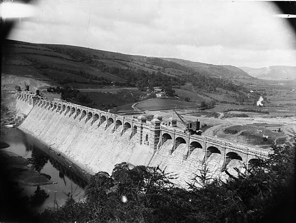
Abertridwr () is a small village in the historic county of Montgomeryshire in the north of Powys and close to Lake Vyrnwy in the community (civil parish) of Llanwddyn. It lies at the confluence of Nant Tridwr (hence the name) with the Vyrnwy river about 1 mile from the latter's exit from the lake. The area surrounding Abertridwr has forests and is used for outdoor pursuits. The nearest significant settlement is Welshpool Welshpool ( cy, Y Trallwng) is a market town and community in Powys, Wales, historically in the county of Montgomeryshire. The town is from the Wales–England border and low-lying on the River Severn; its Welsh language name ''Y Trallwng'' m ..., about 25 km or 15 miles to the south east. External links Photos of Abertridwr and surrounding area on geograph Villages in Powys Llanwddyn {{Powys-geo-stub ... [...More Info...] [...Related Items...] OR: [Wikipedia] [Google] [Baidu] |
Powys
Powys (; ) is a Local government in Wales#Principal areas, county and Preserved counties of Wales, preserved county in Wales. It is named after the Kingdom of Powys which was a Welsh succession of states, successor state, petty kingdom and principality that emerged during the Middle Ages following the end of Roman rule in Britain. Geography Powys covers the historic counties of Montgomeryshire and Radnorshire, most of Brecknockshire, and part of Denbighshire (historic), historic Denbighshire. With an area of about , it is now the largest administrative area in Wales by land and area (Dyfed was until 1996 before several Preserved counties of Wales, former counties created by the Local Government Act 1972 were abolished). It is bounded to the north by Gwynedd, Denbighshire and Wrexham County Borough; to the west by Ceredigion and Carmarthenshire; to the east by Shropshire and Herefordshire; and to the south by Rhondda Cynon Taf, Merthyr Tydfil County Borough, Caerphilly County Bor ... [...More Info...] [...Related Items...] OR: [Wikipedia] [Google] [Baidu] |
Llanwddyn
Llanwddyn () is a village and community in Montgomeryshire, Powys, Wales. The community is centred on the Lake Vyrnwy reservoir. The original Llanwddyn village, about northwest, was submerged when the reservoir was created in the 1880s. Geography Llanwddyn borders the county of Gwynedd to the northeast, with the Powys communities of Llangynog and Pen-y-Bont-Fawr to the northwest, Llanfihangel-yng-Ngwynfa to the south east and Banwy to the southwest. The community is sparsely populated, but includes the village of Abertridwr as well as the new village of Llanwddyn. According to the 2011 census the community had 99 occupied households and a population of 257, with only 84 of the residents born in Wales. This is a 17% decrease since the 310 people noted in 2001. In 2011, only 38% of the population could speak Welsh, a decline from 60% in 2001. Lake Vyrnwy The main feature of the community is the reservoir, which drowned the original village when it was created in the 1880s ... [...More Info...] [...Related Items...] OR: [Wikipedia] [Google] [Baidu] |
Montgomeryshire (Senedd Constituency)
, constituency_type = Senedd county constituency , parl_name=Senedd, image = , image2 = , caption2 = Montgomeryshire shown within the Mid and West Wales electoral region and the region shown within Wales , year = 1999 , member_label = MS , member = Russell George , party_label = Party , party = Conservative , parts_label = Preserved county , parts = Powys Montgomeryshire ( cy, Sir Drefaldwyn) is a constituency of the Senedd. It elects one Member of the Senedd by the first past the post method of election. Also, however, it is one of eight constituencies in the Mid and West Wales electoral region, which elects four additional members, in addition to eight constituency members, to produce a degree of proportional representation for the region as a whole. Boundaries 1999 to 2007 The constituency was created for the first election to the Assembly, in 1999, with ... [...More Info...] [...Related Items...] OR: [Wikipedia] [Google] [Baidu] |
Montgomeryshire (UK Parliament Constituency)
Montgomeryshire ( cy, Sir Drefaldwyn) is a constituency represented in the House of Commons of the Parliament of the United Kingdom. Created in 1542, it elects one Member of Parliament (MP), traditionally known as the knight of the shire, by the first-past-the-post system of election. The Montgomeryshire Senedd constituency was created with the same boundaries in 1999 (as an Assembly constituency). Boundaries The seat is based on the ancient county of Montgomeryshire, in the principal area of Powys. One of Britain's most rural and isolated constituencies, Montgomeryshire elected Liberal or Liberal-affiliated candidates from 1880, until a Conservative victory in the 1979 general election. In the 1983 general election it was the only seat in England and Wales where a sitting Conservative MP was unseated, while nationally the party's seat majority increased. However, in 2010, the Conservatives won and held the seat in 2015 and 2017, with an increased majority. The seat was ... [...More Info...] [...Related Items...] OR: [Wikipedia] [Google] [Baidu] |
Montgomeryshire
Montgomeryshire, also known as ''Maldwyn'' ( cy, Sir Drefaldwyn meaning "the Shire of Baldwin's town"), is one of thirteen historic counties of Wales, historic counties and a former administrative county of Wales. It is named after its county town, Montgomery, Powys, Montgomery, which in turn is named after one of William the Conqueror's main counsellors, Roger de Montgomerie, 1st Earl of Shrewsbury, Roger de Montgomerie, who was the 1st Earl of Shrewsbury. Montgomeryshire today constitutes the northern part of the Subdivisions of Wales#Principal areas of Wales, principal area of Powys. The population of Montgomeryshire was 63,779 according to the United Kingdom Census 2011, 2011 census, with a low population density of just 75 people per square mile (29 people per square km). The current area is 2,174 square km (839 square miles). The largest town is Newtown, Powys, Newtown, followed by Welshpool and Llanidloes. History The Treaty of Montgomery was signed on 29 September 1267, ... [...More Info...] [...Related Items...] OR: [Wikipedia] [Google] [Baidu] |
Lake Vyrnwy
, image = Lakevyrnwysummer.jpg , caption = View overlooking Lake Vyrnwy showing the full extent of the lake , image_bathymetry = , pushpin_map=Wales Powys , caption_bathymetry = , location = Wales , coords = , lake_type = Reservoir , inflow = River Vyrnwy and other small streams , outflow = River Vyrnwy , catchment = , date-built = 1881–88 , date-flooded = , agency = Hafren Dyfrdwysubsidiary of Severn Trent , length = , width = , area = , depth = , max-depth = , volume = , shore = , elevation = Lake Vyrnwy ( cy, Llyn Efyrnwy, or ') is a reservoir in Powys, Wales, built in the 1880s for Liverpool Corporation Waterworks to supply Liverpool with fresh water. It flooded the head of the Vyrnwy ( cy, Afon Efyrnwy) valley and submerged the vi ... [...More Info...] [...Related Items...] OR: [Wikipedia] [Google] [Baidu] |
Community (Wales)
A community ( cy, cymuned) is a division of land in Wales that forms the lowest tier of local government in Wales. Welsh communities are analogous to civil parishes in England. There are 878 communities in Wales. History Until 1974 Wales was divided into civil parishes. These were abolished by section 20 (6) of the Local Government Act 1972, and replaced by communities by section 27 of the same Act. The principal areas of Wales are divided entirely into communities. Unlike in England, where unparished areas exist, no part of Wales is outside a community, even in urban areas. Most, but not all, communities are administered by community councils, which are equivalent to English parish councils in terms of their powers and the way they operate. Welsh community councils may call themselves town councils unilaterally and may have city status granted by the Crown. In Wales, all town councils are community councils. There are now three communities with city status: Bangor, St Asaph ... [...More Info...] [...Related Items...] OR: [Wikipedia] [Google] [Baidu] |
Outdoor Pursuits
Outdoor recreation or outdoor activity refers to recreation done outside, most commonly in natural settings. The activities that encompass outdoor recreation vary depending on the physical environment they are being carried out in. These activities can include fishing, hunting, backpacking (wilderness), backpacking, and horseback riding — and can be completed individually or collectively. Outdoor recreation is a broad concept that encompasses a varying range of activities and landscapes. Outdoor recreation is typically pursued for purposes of physical exercise, general wellbeing, and spiritual renewal. While a wide variety of outdoor recreational activities can be classified as sports, they do not all demand that a participant be an athlete. Rather, it is the collectivist idea that is at the fore in outdoor recreation, as outdoor recreation does not necessarily encompass the same degree of competitiveness or rivalry that is embodied in sporting matches or championships. Compe ... [...More Info...] [...Related Items...] OR: [Wikipedia] [Google] [Baidu] |
Welshpool
Welshpool ( cy, Y Trallwng) is a market town and community in Powys, Wales, historically in the county of Montgomeryshire. The town is from the Wales–England border and low-lying on the River Severn; its Welsh language name ''Y Trallwng'' means "the marshy or sinking land". The community includes Cloddiau and Pool Quay. In English it was initially known as Pool but its name was changed to Welshpool in 1835 to distinguish it from the English town of Poole. The community had a population of 6,664 (as of the 2011 United Kingdom census A census of the population of the United Kingdom is taken every ten years. The 2011 census was held in all countries of the UK on 27 March 2011. It was the first UK census which could be completed online via the Internet. The Office for Nationa ...), with the town having 5,948. It contains much Georgian architecture and is just north of Powis Castle. History St Cynfelin is reputed to be the founder of two churches in the town, St Mary's a ... [...More Info...] [...Related Items...] OR: [Wikipedia] [Google] [Baidu] |
Villages In Powys
A village is a clustered human settlement or community, larger than a hamlet but smaller than a town (although the word is often used to describe both hamlets and smaller towns), with a population typically ranging from a few hundred to a few thousand. Though villages are often located in rural areas, the term urban village is also applied to certain urban neighborhoods. Villages are normally permanent, with fixed dwellings; however, transient villages can occur. Further, the dwellings of a village are fairly close to one another, not scattered broadly over the landscape, as a dispersed settlement. In the past, villages were a usual form of community for societies that practice subsistence agriculture, and also for some non-agricultural societies. In Great Britain, a hamlet earned the right to be called a village when it built a church. [...More Info...] [...Related Items...] OR: [Wikipedia] [Google] [Baidu] |


