|
A69 Road (England)
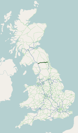
The A69 is a major northern trunk road in England, running east–west across the Pennines, through the counties of Tyne and Wear, Northumberland and Cumbria. Originally, the road started in the centre of Newcastle upon Tyne then later near Birtley, but since the creation of the A1 Western Bypass around Newcastle upon Tyne, it now starts at Denton Burn, a suburb of Newcastle upon Tyne. The route from the A1 junction to Carlisle city centre is 54 miles (87 km). Settlements on the route * Denton Burn * West Denton * Throckley * (Corbridge) * (Hexham) * (Haydon Bridge) * Bardon Mill * Melkridge * (Haltwhistle) * (Brampton) * Warwick Bridge * Warwick-on-Eden * Botcherby * Carlisle Places with parentheses are indicative of historically being on the A69, but have now been bypassed Description of the route The road runs westwards from the A1 at Denton Burn in Newcastle upon Tyne through the suburbs of Denton Burn and West Denton before a junction with the A6085 and the B6323 ... [...More Info...] [...Related Items...] OR: [Wikipedia] [Google] [Baidu] |
A69 Road Map
A69 or A-69 may refer to: * A69 road (England), a road in England * A69 type, another name for the ''D'Estienne d'Orves'' class of French anti-submarine corvettes * Benoni Defense, Encyclopaedia of Chess Openings code * HLA-A69, an HLA-A serotype * Abashiri Station, a station in Abashiri, Hokkaido, Japan, station code A69 {{Letter-NumberCombDisambig ... [...More Info...] [...Related Items...] OR: [Wikipedia] [Google] [Baidu] |
Bardon Mill
Bardon Mill is a small village in Northumberland, within the vicinity of the ancient Hadrian's Wall. It is located around from Hexham, from Carlisle, and from Newcastle upon Tyne. Nearby landmarks include Allen Banks & Staward Gorge, Sycamore Gap, The Sill: National Landscape Discovery Centre and Vindolanda Roman Fort. Amenities The local pub in Bardon Mill iThe Bowes Hotel Church services alternate weekly between St. Cuthbert's Church at Beltingham and the Church of All Hallows at Henshaw, both of which are very close to the village. There is a very active Women's Institute. A leek club show is held every year, the produce from which is auctioned along with donations the day after the show. Funds are then donated to local charities. Every October, there is the Bardon Mill and Roman Empire conkers championships, which is held on the village green. Local community projects are asked to run a stall at the event to raise funds for their own or community projects. Demograph ... [...More Info...] [...Related Items...] OR: [Wikipedia] [Google] [Baidu] |
A689 Road
The A689 is a road in northern England that runs east from the A595, to the west of Carlisle in Cumbria, to Hartlepool in County Durham. The road begins west of Carlisle, just outside the city at the A595. The initial stretch was recently constructed as part of the Carlisle Northern Development Route, a road bypassing Carlisle from west to north. Crossing the River Eden and the West Coast Main Line, the road intersects with Junction 44 of the M6 at Greymoorhill. From Junction 44 of the M6, the A689 runs roughly south-east to a roundabout, with the B6264. From here, the A689 heads east, and crosses the River Irthing at Ruleholme, then it meets the A69 at a roundabout junction. The A689 joins the route of the A69 around part of the Brampton bypass. Near the village of Milton, the A689 turns right, and continues through Milton and Hallbankgate before crossing the border into the county of Northumberland. The route continues roughly south-east, and re-enters the county o ... [...More Info...] [...Related Items...] OR: [Wikipedia] [Google] [Baidu] |
Roundabout
A roundabout is a type of circular intersection or junction in which road traffic is permitted to flow in one direction around a central island, and priority is typically given to traffic already in the junction.''The New Shorter Oxford English Dictionary,'' Volume 2, Clarendon Press, Oxford (1993), page 2632 Engineers use the term modern roundabout to refer to junctions installed after 1960 that incorporate various design rules to increase safety. Both modern and non-modern roundabouts, however, may bear street names or be identified colloquially by local names such as rotary or traffic circle. Compared to stop signs, traffic signals, and earlier forms of roundabouts, modern roundabouts reduce the likelihood and severity of collisions greatly by reducing traffic speeds and minimizing T-bone and head-on collisions. Variations on the basic concept include integration with tram or train lines, two-way flow, higher speeds and many others. For pedestrians, traffic exiting th ... [...More Info...] [...Related Items...] OR: [Wikipedia] [Google] [Baidu] |


