|
A361 Road
The A361 is an A class road in southern England, which at is the longest three-digit A road in the UK. History When first designated in 1922, the A361 ran from Taunton (Somerset) to Banbury (Oxfordshire). It was later extended west through Bampton to South Molton (Devon), on the route of the former A398, and from South Molton to Barnstaple and Ilfracombe, previously part of the route of the A373. In 1988, when the North Devon Link Road was opened, the A361 was switched to its present route. The old route from Taunton through Bampton to South Molton was downgraded to become the B3227. In the 1970s the route was extended north from Banbury to Daventry (Northamptonshire), providing a link to the M1 motorway near Crick. Route Devon The road starts in Ilfracombe as part of the town's High Street, and is mostly single carriageway. The road passes through the villages of Knowle and Braunton, before becoming dual carriageway standard at Ashford, which continues for the short di ... [...More Info...] [...Related Items...] OR: [Wikipedia] [Google] [Baidu] |
Frome
Frome ( ) is a town and civil parish in eastern Somerset, England. The town is built on uneven high ground at the eastern end of the Mendip Hills, and centres on the River Frome. The town, about south of Bath, is the largest in the Mendip district of Somerset and is part of the parliamentary constituency of Somerton and Frome. The population was 28,559 in 2021. Frome was one of the largest towns in Somerset until the Industrial Revolution, and was larger than Bath from AD 950 until 1650. The town first grew due to the wool and cloth industry; it later diversified into metal-working and printing, although these have declined. The town was enlarged during the 20th century but retains a large number of listed buildings, and most of the centre falls within a conservation area. In the 2011 census, the population was given as 26,203. The town has road and rail transport links and acts as an economic centre for the surrounding area. It provides a centre for cultural and sport ... [...More Info...] [...Related Items...] OR: [Wikipedia] [Google] [Baidu] |
Crick, Northamptonshire
Crick is a village in West Northamptonshire in England. It is close to the border with Warwickshire, east of Rugby and northwest of Northampton. The villages of Crick and West Haddon were by-passed by the A428 main road from Rugby to Northampton when the Daventry International Rail Freight Terminal (DIRFT) was built in 1996. The terminal is a short distance east of junction 18 of the M1 motorway, which is next to Crick. Crick's population in the 2001 census was 1,460, increasing to 1,886 at the 2011 census. History Crick takes its name from the Brittonic Celtic word for “hill,” “cruc.” There are many similar examples across Wales, for example Crughywel, Crug Mawr and Crickadarn. Crack's Hill () is about northeast of the village, next to the canal, and gives good views of Crick, Yelvertoft, West Haddon and Rugby from the top. Kilsby and Crick railway station was located west of the village between 1881 and 1960. Notable buildings The Historic England websi ... [...More Info...] [...Related Items...] OR: [Wikipedia] [Google] [Baidu] |
A4 Road (England)
The A4 is a major road in England from Central London to Avonmouth via Heathrow Airport, Reading, Bath and Bristol. It is historically known as the Bath Road with newer sections including the Great West Road and Portway. The road was once the main route from London to Bath, Bristol and the west of England and formed, after the A40, the second main western artery from London. Although most traffic is carried by the M4 motorway today, the A4 still acts as the main route from Bristol to London for non-motorway traffic. History Turnpikes The A4 has gone through many transformations through the ages from pre-Roman routes, Roman roads (such as the one passing Silbury Hill), and basic wagon tracks. During the Middle Ages, most byways and tracks served to connect villages with their nearest market town. A survey of Savernake Forest near Hungerford in 1228 mentions "The King's Street" running between the town and Marlborough. This street corresponded roughly with the route ... [...More Info...] [...Related Items...] OR: [Wikipedia] [Google] [Baidu] |
East Somerset Railway
The East Somerset Railway is a heritage railway in Somerset, running between Cranmore and Mendip Vale. Prior to the Beeching Axe, the railway was once part of the former Cheddar Valley line that ran from Witham to Yatton, meeting the Somerset and Dorset Joint Railway at Wells. History The East Somerset Railway Company was incorporated under the East Somerset Railway Act on 5 June 1856 and was built as a broad gauge line. The line was originally between Witham railway station and Shepton Mallet and this line opened on 9 November 1858. It was planned by Mr. Brunel and built by engineer Mr. Ward and contractor Mr. Brotherwood. The station buildings at Shepton and Witham Friary, as well as the bridges along the route, were constructed of Inferior Oolite from nearby Doulting Stone Quarry. Shepton was now from London by rail, a journey of just over four hours. Four years later the line was extended to Wells; this part of the line was opened on 1 March 1862. The East Som ... [...More Info...] [...Related Items...] OR: [Wikipedia] [Google] [Baidu] |
Cranmore, Somerset
Cranmore is a village and civil parish east of Shepton Mallet, in the Mendip district of Somerset, England. The parish includes the hamlets of Waterlip, East Cranmore and Dean. History The name comes from ''Crane Mere'', the Lake of the Cranes. The parish of Cranmore was part of the hundred of Wells Forum. East Cranmore was part of the hundred of Frome. It is the base of the East Somerset Railway which plays host to a variety of preserved diesel and steam locomotives. It operates the line between Cranmore railway station, Cranmore West, Merryfield Lane Halt and Mendip Vale. The section between Cranmore and the mainline is used for heavy quarry traffic to the nearby Merehead Quarry. The quarry, which is also known as Torr Works, covers an area of some 200 hectares, including 60 hectares which have been landscaped to blend with the surrounding countryside. It was once operated by the Foster Yeoman Company, but now owned and operated by Aggregate Industries LTD, employing ov ... [...More Info...] [...Related Items...] OR: [Wikipedia] [Google] [Baidu] |
Curry And Hay Moors
Curry and Hay Moors () is a 472.8 hectare (1168.1 acre) biological Site of Special Scientific Interest in Somerset, notified in 1992. Curry and Hay Moors form part of the complex of grazing marshes known as the Somerset Levels and Moors. The low-lying site is situated adjacent to the River Tone which annually overtops, flooding the fields in winter. Soils are predominantly alluvial clays overlying Altcar series peats. The flora and fauna of the ditches and rhynes is of national importance. Over 70 aquatic and bankside vascular plants have been recorded including frogbit (''Hydrocharis morsus-ranae''), flowering rush (''Butomus umbellatus''), wood club-rush (''Scirpus sylvaticus'') and lesser water-plantain (''Baldellia ranunculoides''). Over 100 species of aquatic invertebrates inhabit the ditches including one nationally rare soldier fly, (''Odontomyia ornata'') and 13 nationally scarce species including the water beetles ''Agabus uliginosus'', ''Hydaticus transvers ... [...More Info...] [...Related Items...] OR: [Wikipedia] [Google] [Baidu] |
Somerset Levels
The Somerset Levels are a coastal plain and wetland area of Somerset, England, running south from the Mendips to the Blackdown Hills. The Somerset Levels have an area of about and are bisected by the Polden Hills; the areas to the south are drained by the River Parrett, and the areas to the north by the rivers Axe and Brue. The Mendip Hills separate the Somerset Levels from the North Somerset Levels. The Somerset Levels consist of marine clay "levels" along the coast and inland peat-based "moors"; agriculturally, about 70 per cent is used as grassland and the rest is arable. Willow and teazel are grown commercially and peat is extracted. A Palaeolithic flint tool found in West Sedgemoor is the earliest indication of human presence in the area. The Neolithic people exploited the reed swamps for their natural resources and started to construct wooden trackways, including the world's oldest known timber trackway, the Post Track, dating from about 3800 BC. The Levels were ... [...More Info...] [...Related Items...] OR: [Wikipedia] [Google] [Baidu] |
M5 Motorway
The M5 is a motorway in England linking the Midlands with the South West England, South West. It runs from junction 8 of the M6 motorway, M6 at West Bromwich near Birmingham to Exeter in Devon. Heading south-west, the M5 runs east of West Bromwich and west of Birmingham through Sandwell Valley. It continues past Bromsgrove (and from Birmingham and Bromsgrove is part of the Birmingham Motorway Box), Droitwich Spa, Worcester, England, Worcester, Tewkesbury, Cheltenham, Gloucester, Bristol, Clevedon, Weston-super-Mare, Bridgwater, Taunton, terminating at junction 31 for Exeter. Congestion on the section south of the M4 motorway, M4 is common during the summer holidays, on Friday afternoons and bank holidays. Route The M5 quite closely follows the route of the A38 road. The two deviate slightly around Bristol and the area south of Bristol from junctions 16 to the Sedgemoor services north of junction 22. The A38 goes straight through the centre of Bristol and passes by Bristol Airp ... [...More Info...] [...Related Items...] OR: [Wikipedia] [Google] [Baidu] |
A38 Road
The A38, parts of which are known as Devon Expressway, Bristol Road and Gloucester Road, is a major A-class trunk road in England. The road runs from Bodmin in Cornwall to Mansfield in Nottinghamshire. It is long, making it the longest two-digit A road in England. It was formerly known as the ''Leeds–Exeter Trunk Road'', when this description also included the A61. Before the opening of the M5 motorway in the 1960s and 1970s, the A38 formed the main "holiday route" from the Midlands to Somerset, Devon and Cornwall. Considerable lengths of the road in the West Midlands closely follow Roman roads, including part of Icknield Street. Between Worcester and Birmingham the current A38 follows the line of a Saxon salt road; For most of the length of the M5 motorway, the A38 road runs alongside it as a single carriageway road. Route description Bodmin to Birmingham The road starts on the eastern side of Bodmin at a junction with the A30 before traversing the edge of the to ... [...More Info...] [...Related Items...] OR: [Wikipedia] [Google] [Baidu] |
Devon And Somerset Railway
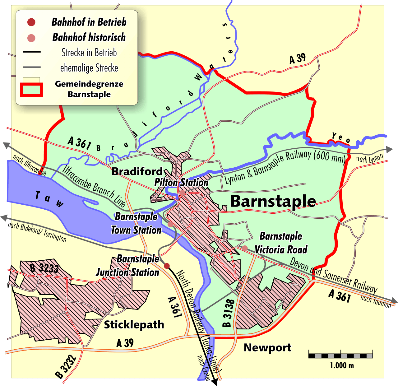
The Devon and Somerset Railway (D&SR) was a cross-country line that connected Barnstaple in Devon, England, to the network of the Bristol and Exeter Railway (B&ER) near Taunton. It was opened in stages between 1871 and 1873 and closed in 1966. It served a mostly rural area although it carried some through services from east of Taunton to the seaside resort of Ilfracombe. From 1988 onwards the route of the line west of South Molton was redeveloped to form the part of the North Devon Link Road. History The Act of Parliament that authorised the D&SR received assent on 29 July 1864. Eugenius Birch was appointed as Engineer, but he was replaced by Richard Hassard in 1870. The first section of the line was opened on 8 June 1871, from Watchet Junction (later Norton Fitzwarren) to on the edge of Exmoor. The remaining to Barnstaple opened on 1 November 1873. The line used its own station at Barnstaple (later to be named Victoria Road), some distance from the rival station at Barn ... [...More Info...] [...Related Items...] OR: [Wikipedia] [Google] [Baidu] |
Tiverton Parkway Railway Station
Tiverton Parkway railway station is on the Bristol to Exeter line in Devon, England. The "Parkway" name signifies that the station is a distance from Tiverton town itself: it is actually located in the civil parish of Burlescombe, near Sampford Peverell, to the east of Tiverton, and close to the junction of the M5 motorway with the A361 North Devon link road. It is from the zero point at via . The station is operated by Great Western Railway and is also served by CrossCountry trains. History The Bristol and Exeter Railway opened on 1 May 1844 but it ran south of Tiverton, so a station known as "Tiverton Road" was opened to serve the town. This station was renamed " Tiverton Junction" on 12 June 1848 when the Tiverton branch line was opened to a station in the town itself. By the 1980s the branch to Tiverton had closed and Tiverton Junction station only saw a couple of trains in each direction each day so a decision was taken to relocate the station a short distan ... [...More Info...] [...Related Items...] OR: [Wikipedia] [Google] [Baidu] |


