|
A1 Motorway (Serbia)
The A1 motorway ( sr, Аутопут А1, Autoput A1) is a motorway in Serbia and at it is the longest motorway in Serbia. It crosses the country from north to south, starting at the Horgoš border crossing with Hungary and ending at the Preševo border crossing with North Macedonia. As a part of the European route E75 and Pan-European corridor X, connecting 4 of 5 largest Serbian cities (Belgrade, Novi Sad, Niš and Subotica), it is the most vital part of the Serbian road network. Route ;Northern section The northern section ( Hungarian border – Subotica – Novi Sad – Belgrade) is 172 km long and was built between 1971 and 2013. The first subsection of this section to be opened is the Belgrade (Batajnica) – Novi Sad stretch. It was built between 1971 and 1975, but only a single carriageway was constructed at the time. It is 56.3 km long, and it includes the Beška Bridge (2,205 m) on the Danube river, which is the longest bridge on the Serbian road networ ... [...More Info...] [...Related Items...] OR: [Wikipedia] [Google] [Baidu] |
Putevi Srbije
JP Putevi Srbije ( sr, ЈП Путеви Србије) or Roads of Serbia, is a Serbian Construction industry, construction company headquartered in Belgrade, Serbia. It is the national road construction company of Serbia. Organization Putevi Srbija was established by the ''Enactment'' of the Government of Serbia, as the state-owned enterprise responsible for "professional activities referring to permanent, continuous and good-quality maintenance and preservation, exploitation, construction, reconstruction, organization and control of toll collection, development and management of I and II category state roads in the Republic of Serbia". In current form, it operates since 20 February 2006. Road network managed by "Putevi Srbije" consists of of I and II category state roads, valued at 4.483 billion euros as of December 2018. As of December 2019, the total state roads network in Serbia is as follows: * Ia category (motorways) – * Ib category – * IIa category – * IIb categ ... [...More Info...] [...Related Items...] OR: [Wikipedia] [Google] [Baidu] |
Beška Bridge
Beška Bridge ( sr, Мост код Бешке, Most kod Beške) crosses the Danube river near Beška, Serbia on the A1 motorway, part of the European route E75. It consists of two identical prestressed concrete constructions, the first being completed in 1975 and the second in 2011. With 2,205 m total length, it is the longest bridge over the Danube. The first bridge was designed by architect Branko Žeželj, who also designed Belgrade Fair – Hall 1, Žeželj Bridge and the Prokop station. It was built by Mostogradnja from 1971 to 1975. It was bombed twice and partly destroyed during the NATO bombing of Serbia on 1 April and 21 April 1999, but it was temporarily fixed soon after the bombing was over and reopened on 19 July 1999, as it is an important part of the E75. A twin new bridge for northbound traffic was built right next to the old one between 2008 and 2011, by a consortium led by Austrian group Alpine Bau, and was opened on October 3, 2011. After its opening, the ... [...More Info...] [...Related Items...] OR: [Wikipedia] [Google] [Baidu] |
Pannonian Basin
The Pannonian Basin, or Carpathian Basin, is a large Sedimentary basin, basin situated in south-east Central Europe. The Geomorphology, geomorphological term Pannonian Plain is more widely used for roughly the same region though with a somewhat different sense, with only the Upland and lowland, lowlands, the plain that remained when the Pliocene Epoch ''Pannonian Sea'' dried out. It is a geomorphological subsystem of the Alpide belt, Alps-Himalaya system, specifically a sediment-filled back-arc basin which divergent boundary, spread apart during the Miocene. The plain or basin is diagonally bisected by the Transdanubian Mountains, separating the larger Great Hungarian Plain (including the Eastern Slovak Lowland) from the Little Hungarian Plain. It forms a topographically discrete unit set in the European landscape, surrounded by imposing geographic boundaries—the Carpathian Mountains and the Alps. The Rivers Danube and Tisza divide the basin roughly in half. It extends rough ... [...More Info...] [...Related Items...] OR: [Wikipedia] [Google] [Baidu] |
Vojvodina
Vojvodina ( sr-Cyrl, Војводина}), officially the Autonomous Province of Vojvodina, is an autonomous province that occupies the northernmost part of Serbia. It lies within the Pannonian Basin, bordered to the south by the national capital Belgrade and the Sava and Danube Rivers. The administrative center, Novi Sad, is the second-largest city in Serbia. The historic regions of Banat, Bačka, and Syrmia overlap the province. Modern Vojvodina is multi-ethnic and multi-cultural, with some 26 ethnic groups and six official languages. About two million people, nearly 27% of Serbia's population, live in the province. Naming ''Vojvodina'' is also the Serbian word for voivodeship, a type of duchy overseen by a voivode. The Serbian Voivodeship, a precursor to modern Vojvodina, was an Austrian province from 1849 to 1860. Its official name is the Autonomous Province of Vojvodina. Its name in the province's six official languages is: * Croatian: ''Autonomna Pokrajina Vojvodina'' * ... [...More Info...] [...Related Items...] OR: [Wikipedia] [Google] [Baidu] |
Belgrade Bypass
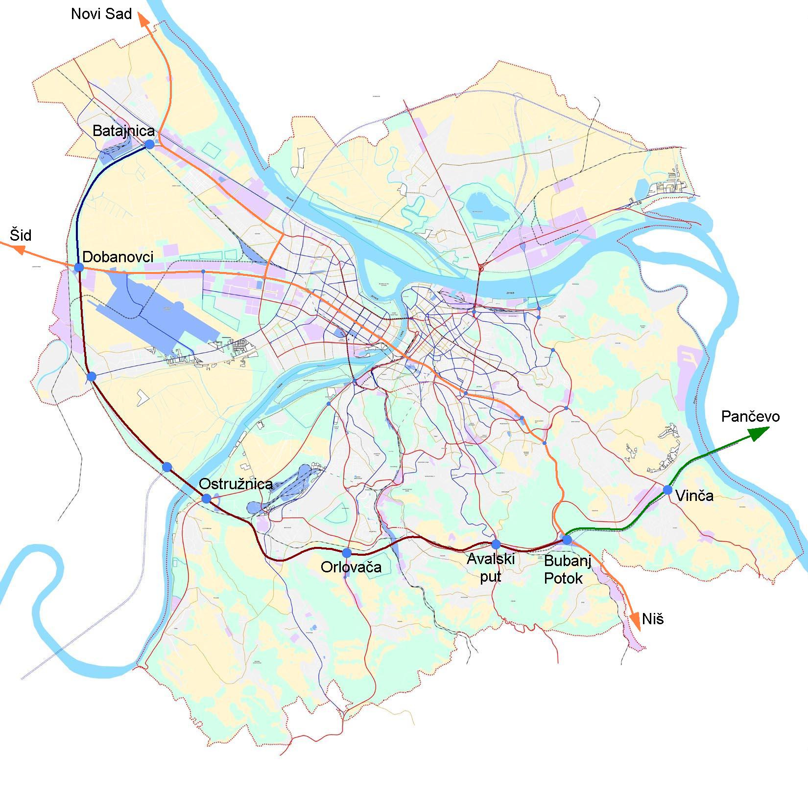
The Belgrade bypass ( sr, Обилазница око Београда, Obilaznica oko Beograda) or Belgrade city road bypass is a U-shaped, 69-km long motorway partially encircling the city of Belgrade, the capital of Serbia. Some 9.6 km of the bypass is the section of A1 motorway (currently under construction), and the rest is planned eastern extension of A3. The construction of the bypass started in 1990 and its parts have been sporadically built ever since. Its completion is expected to help alleviate Belgrade's traffic congestion, and remove all transit traffic from the city itself. Route ;Sector A (Batajnica - Dobanovci, A3 interchange) Sector A is 11.1 km long part of A1 motorway that intersects with A3 motorway at Dobanovci interchange. It is completed and opened to traffic in 2012. ;Sector B (Dobanovci, A3 interchange – Bubanj Potok) Sector B is 37.2 km long part of A1 motorway that intersects with A2 motorway at Surčin interchange. It is currently ... [...More Info...] [...Related Items...] OR: [Wikipedia] [Google] [Baidu] |
Batajnica
Batajnica ( sr-Cyrl, Батајница, ) is an urban neighborhood of Belgrade, the capital city of Serbia. It is located in the Belgrade municipality of Zemun. Location and geography Batajnica is located in the Syrmia region, in the northern part of the municipality, close to the administrative border of the province of Vojvodina and it is both the northernmost and the westernmost part of the Belgrade's urban area. It is close to the Danube's right bank, but not on the river itself, due to the floodings. A small, 114 metre-high hillock separates the settlement from the river. It is some 15 kilometres away from downtown Belgrade, but only 6 kilometres away from Nova Pazova and Novi Banovci, fast growing settlements in the Vojvodina's municipality of Stara Pazova, to which it almost makes a continuous built-up area. : it extends to the southwest in the direction of Ugrinovci's neighborhood of Busije and southeast in the direction of other Zemun's neighborhoods: Zemun Polje, Ga ... [...More Info...] [...Related Items...] OR: [Wikipedia] [Google] [Baidu] |
Stara Pazova
Stara Pazova (, ; hu, Ópazova) is a town and municipality located in the Srem District of the autonomous province of Vojvodina, Serbia. The town has a population of 64792, while Stara Pazova municipality has 65,792 inhabitants. The entrance into town from Inđija lies on 45th parallel north, it is half-way between the North pole and the equator. Name In Serbian, the town is known as ''Stara Pazova'' (Стара Пазова), formerly also ''Pazova'' (Пазова); in Slovak as ''Stará Pazova''; in German as ''Alt-Pasua'', ''Alt-Pazua'' or ''Pazua''; and in Hungarian as ''Ópazova''. History During the Ottoman administration (16th-18th century), Pazova was populated by ethnic Serbs and was part of the Ottoman Sanjak of Syrmia. In 1718, the town became part of the Habsburg monarchy. In the 18th century (after 1760) Lutheran Slovaks settled in Pazova, and in 1791 Germans arrived here as well. The Germans lived in a separate settlement known as Nova Pazova ("New Pazova"), thu ... [...More Info...] [...Related Items...] OR: [Wikipedia] [Google] [Baidu] |
Inđija
Inđija (, ; hu, India) is a town and a municipality located in the Srem District of the autonomous province of Vojvodina, Serbia. As of 2011, the town has total population of 26,025, while the municipality has 47,433 inhabitants. It is located in the geographical region of Syrmia. Name According to the legend, the name of the town comes from Turkish word "ikindia" – meaning evening prayer and is related to the time after 1699 when the town fell under Turkish rule. On the other hand, there is the claim that the town was named after the name of Orthodox women – Inđija. Newest researches states that name of the city is taken from Latin word "Indigena" meaning "indigenous". This theory is most relevant, due to presence of ancient Illyrian, Celtic and Roman settlements in neighbourhood of modern Inđija. In Serbo-Croatian, the town is known as (), in Hungarian as ''Ingyia'', in German as ''India'', in Slovak as ''India'' or ''Indjija'', and in Rusyn as Индїя. ... [...More Info...] [...Related Items...] OR: [Wikipedia] [Google] [Baidu] |
Srem
Syrmia ( sh, Srem/Срем or sh, Srijem/Сријем, label=none) is a region of the southern Pannonian Plain, which lies between the Danube and Sava rivers. It is divided between Serbia and Croatia. Most of the region is flat, with the exception of the low Fruška gora mountain stretching along the Danube in its northern part. Etymology The word "Syrmia" is derived from the ancient city of Sirmium (now Sremska Mitrovica). Sirmium was a Celtic or Illyrian town founded in the third century BC. ''Srem'' ( sr-cyr, Срем) and ''Srijem'' are used to designate the region in Serbia and Croatia respectively. Other names for the region include: * Latin: ''Syrmia'' or ''Sirmium'' * Hungarian: ''Szerémség'', ''Szerém'', or ''Szerémország'' * German: ''Syrmien'' * Slovak: ''Sriem'' * Rusyn: Срим * Romanian: ''Sirmia'' History Prehistory Between 3000 BC and 2400 BC, Syrmia was at the centre of Indo-European Vučedol culture. Roman era Sirmium was conquer ... [...More Info...] [...Related Items...] OR: [Wikipedia] [Google] [Baidu] |
Vrbas, Serbia
Vrbas ( sr-Cyrl, Врбас; hu, Verbász) is a town and municipality located in the South Bačka District of the autonomous province of Vojvodina, Serbia. As of 2011, the town had a population of 24,112, while the municipality had 42,092 inhabitants. Name Its name stems from the word "Willow" in the Serbian language. During the SFRY period, the town was renamed ''Titov Vrbas'' (meaning "the Vrbas of Tito"), after Josip Broz Tito. Like all other towns in Socialist Yugoslavia named after Tito, the first part was dropped once the new states were formed during the early 1990s. In Rusyn, the town is known as ''Вербас'', in Hungarian as ''Verbász'', in Croatian as ''Vrbas'', in German as ''Werbass'', and in Turkish as ''Verbas''. History Vrbas was mentioned first in 1213 during the administration of the Kingdom of Hungary. According to other sources, it was mentioned first in 1387. In the 16th century it became a part of the Ottoman Empire. During Ottoman administration i ... [...More Info...] [...Related Items...] OR: [Wikipedia] [Google] [Baidu] |
Bačka Topola
Bačka Topola ( sr-Cyrl, Бачка Топола, ; hu, Topolya, ) is a town and municipality located in the North Bačka District of the autonomous province of Vojvodina, Serbia. The municipality is composed of 23 local communities and has a population of 33,321, while the town itself has 14,573 inhabitants. Name The name of the town is derived from the Serbian word ''topola'' (топола) ("poplar" in English). The first part of the name of the town was given to designate its location in the region of Bačka in contrast to places with similar names, like Topola in Šumadija or Banatska Topola in Banat. History The town was mentioned first in 1462 under name ''Fibaych''. This settlement was destroyed in the 16th century and new smaller settlement was later built at its location. Name ''Topola'' was first recorded in 1543, while according to the Ottoman defters from 1580, 1582, and 1590, it was mentioned as a village, whose population numbered between 21 and 23 houses. In ... [...More Info...] [...Related Items...] OR: [Wikipedia] [Google] [Baidu] |


