|
Armadale Station, Perth
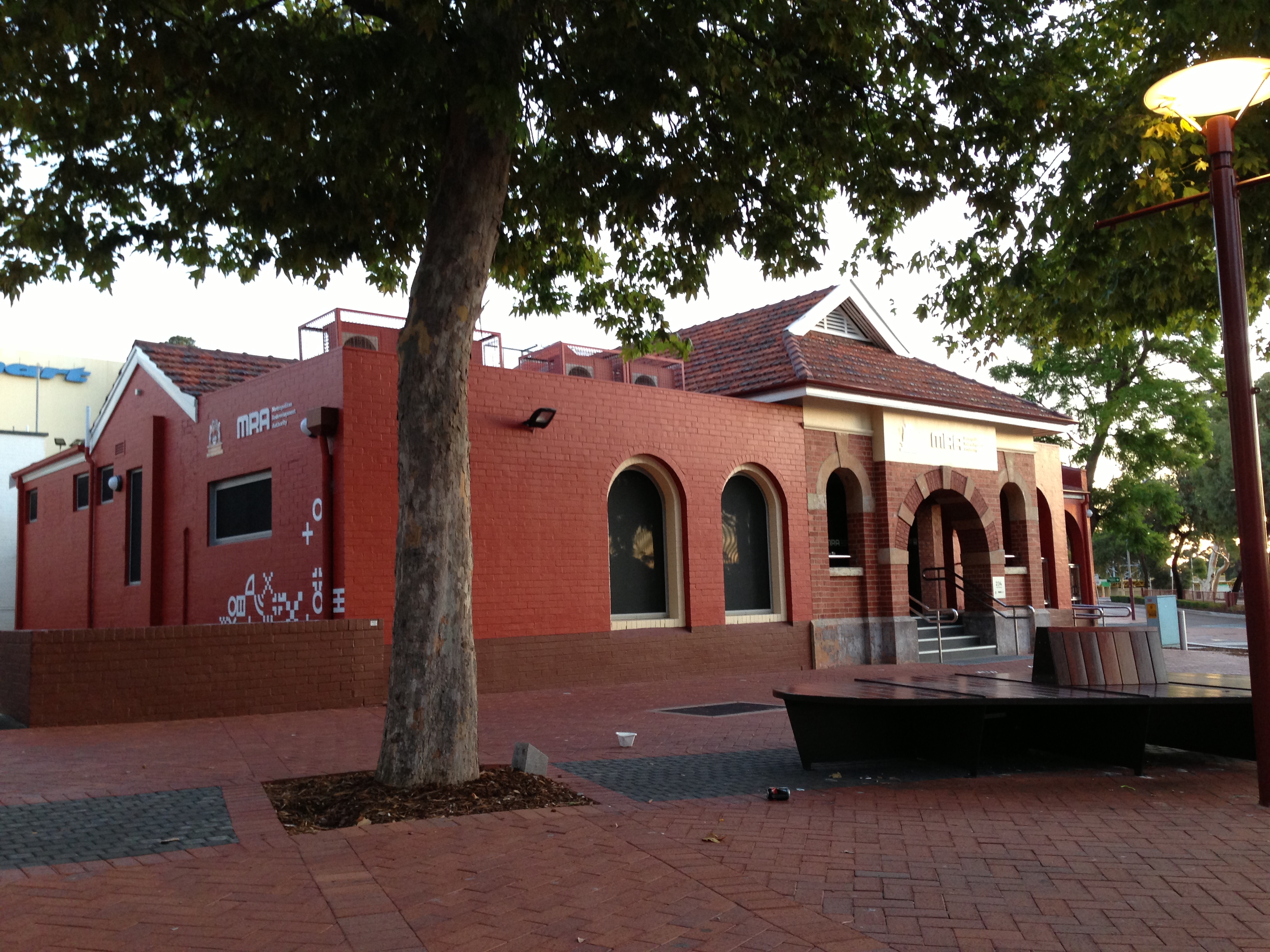
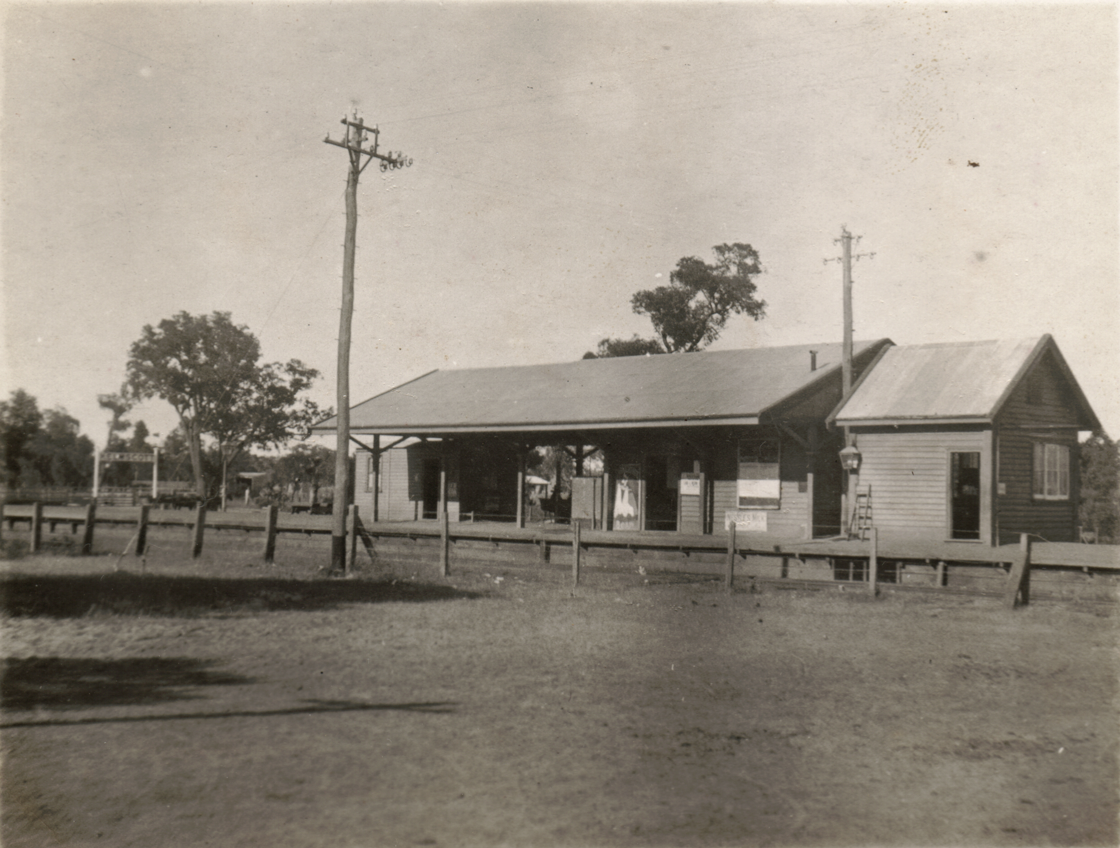
Armadale Station is a railway station on the South Western Railway, 30 kilometres from Perth station serving the suburb of Armadale, Brookdale and Haynes. It is the terminating point for Transperth Armadale line services and a calling point for Transwa ''Australind'' services. History The original station opened on 2 May 1893 when the South Western Railway opened from Claisebrook to Pinjarra. As part of the electrification of the line in the early 1990s, a new station was built with the former signal box relocated to the Armadale Tourist Centre. On 6 November 2004 another new station opened. On 15 July 1907 Armadale became a junction station when the Spearwood-Armadale line opened. This line closed on 23 January 1964. Services Armadale station is the terminus for Transperth Armadale Line services. It is also served by Transwa ''Australind'' services to Bunbury. For a time, ''The Australind'' did stop at Kelmscott, however this was reverted in April 1992. The station sa ... [...More Info...] [...Related Items...] OR: [Wikipedia] [Google] [Baidu] |
Armadale, Western Australia
Armadale is a suburb of Perth within the City of Armadale, located on the south-eastern edge of the Perth metropolitan region. The major junction of the South Western and Albany Highways, which connect Perth with the South West and Great Southern regions of Western Australia respectively, is located within the suburb. It is also the terminus of the Armadale railway line, one of five major railway lines to service Perth. History Plentiful in natural resources, the area now known as Armadale was long occupied by Aboriginal people prior to the founding of the Swan River Colony. Records of encounters with the original Aboriginal inhabitants of this district are sparse in detail, but early on there was conflict between these inhabitants and the settlers, which led to the establishment of a small garrison at Kelmscott. The township of Kelmscott was gazetted in 1830, and for the next sixty years was the administrative and social hub for those colonists who took up land between pres ... [...More Info...] [...Related Items...] OR: [Wikipedia] [Google] [Baidu] |
Kelmscott Station
Kelmscott railway station is located on the South Western Railway, 25.9 kilometres from Perth Station in the suburb of Kelmscott. It is served by Armadale Line services which are part of the Transperth network. History Kelmscott station opened on 2 May 1893 as one of the original stations on the Armadale Line. On 2 July 1980, a bus interchange opened on the platform. In 2008, the Public Transport Authority completed a $10.8 million upgrade of the station. Services Kelmscott station is served by Transperth Transperth is the brand name of the public transport system serving the city and suburban areas of Perth, the state capital of Western Australia. It is managed by the Public Transport Authority (PTA), a state government organisation. Train op ... Armadale Line services. Until April 1992, it was served by ''The Australind''. The station saw 496,711 passengers in the 2013-14 financial year. Platforms Bus routes References External links * ... [...More Info...] [...Related Items...] OR: [Wikipedia] [Google] [Baidu] |
Public Transport Centre
The Public Transport Centre (formerly known as the Westrail Centre) is a terminal and administration building for public transport in Perth, Western Australia. It is the centerpiece of East Perth Terminal (formerly known as Perth Terminal), a standard gauge railway station and coach terminal adjacent to East Perth station on the Transperth narrow gauge suburban rail network. Previous use The site occupied by East Perth station, East Perth Terminal, and the Public Transport Centre was formerly the East Perth Locomotive Depot. East Perth Railway Terminal As part of the gauge conversion of the Eastern Goldfields Railway, a new standard gauge terminus was opened in 1969. The station has one side platform and a dock platform at its northern end. Today the station is served by Journey Beyond's ''Indian Pacific'', and Transwa's ''Prospector'' and ''MerredinLink'' services. Until it ceased in June 1991, the terminal was also served by the ''Trans-Australian''. Administration bu ... [...More Info...] [...Related Items...] OR: [Wikipedia] [Google] [Baidu] |
Albany Highway
Albany Highway links Western Australia's capital city Perth with its oldest settlement, Albany, on the state's south coast. The highway travels through the southern Wheatbelt and Great Southern regions, and is designated State Route 30 for most of its length. Outside of Perth the highway is predominately a sealed, single carriageway with regular overtaking lanes in some undulating areas. Albany Highway commences at The Causeway, a river crossing that connects to Perth's central business district. The highway heads south-east through Perth's metropolitan region, bypassed in part by Shepperton Road and Kenwick Link, and continues south-eastwards through to Albany. It intersects several major roads in Perth, including the Leach, Tonkin, Brookton, and South Western highways. The rural section of Albany Highway connects to important regional roads at the few towns and roadhouses along the route, including Coalfields Highway at Arthur River, Great Southern Highway at ... [...More Info...] [...Related Items...] OR: [Wikipedia] [Google] [Baidu] |
Perth Busport
Perth Busport is an underground bus station, located underneath Wellington Street, Perth, Western Australia. It was officially opened by then Premier of Western Australia Colin Barnett and then Minister for Transport Dean Nalder on 13 July 2016. Description Perth Busport is located underground, west of Perth railway station, between Wellington, Roe Street and Milligan streets. There are two bus access points, from Wellington Street and Milligan Street, and three passenger entrances, at Yagan Square, Queen Street, and King Street. The underground lounge is air-conditioned, contains 160 seats, two kiosks, and digital screens displaying updated departure information. Buses loop around the lounge, which is surrounded by double-glazed glass, and has sixteen stands grouped into four areas, each with four stands. History Perth Busport commenced operations on 17 July 2016, served by 25 Transperth routes operated by Path Transit, Swan Transit and Transdev WA. The temporary Roe Str ... [...More Info...] [...Related Items...] OR: [Wikipedia] [Google] [Baidu] |
Burswood, Western Australia
Burswood is an inner southeastern suburb of Perth, Western Australia, located immediately across the Swan River from Perth's central business district (CBD). Its local government area is the Town of Victoria Park. Burswood is the location of the State Tennis Centre, Perth Stadium, Belmont Park Racecourse, and the Crown Perth casino and hotel complex. History Burswood developed as two separate entities Burswood Island, and a southernmost part within the suburb of Victoria Park until the 1990s. Henry Camfield, who emigrated from England to the Swan River Colony in 1829, with two indentured servants and their families, was granted of land opposite Claisebrook. Camfield named the estate after his father's farm, Burrswood, near Groombridge in Kent. The area was a low-lying peninsula leading to a ridge and steep, sandy hill with scrubland beyond. The peninsula became Burrswood Island in 1841 when Burswood canal was cut to offer a more direct route to Guildford, which had previo ... [...More Info...] [...Related Items...] OR: [Wikipedia] [Google] [Baidu] |
Crown Perth
Crown Perth (formerly Burswood Island Casino, Burswood Island Complex and Burswood Entertainment Complex) is a resort and casino located in Burswood, Western Australia, near the Swan River. The resort consists of a casino, a convention centre with meeting rooms, theatre and two ballrooms along with 32 restaurants and bars, a nightclub and recreational facilities. It also features three hotels: the 405-room Crown Metropol Perth, the 291-room Crown Promenade Perth and the 500-room luxury hotel Crown Towers Perth, which was opened in December 2016. History 1980s In 1984, the Western Australian Government proposed, at the suggestion of Perth businessman Dallas Dempster, that a casino complex be constructed at Burswood Island on the Swan River, east of the Perth city centre. This was the site of a large landfill facility, which posed difficulties in the proposal, design and construction phases due to the risk of subsidence resulting from decomposition and also the risk of rele ... [...More Info...] [...Related Items...] OR: [Wikipedia] [Google] [Baidu] |
South Western Highway
South Western Highway is a highway in the South West region of Western Australia connecting Perth's southeast with Walpole. It is a part of the Highway 1 network for most of its length. It is about long. Route description Perth to Bunbury From Perth, the highway, signed as State Route 20, starts from the Albany Highway junction in Armadale, 28 km from Perth, and follows a north–south route 20–30 km inland from the coast, passing through several agricultural and timber towns that sprang up in the 1890s when the nearby railway came through, such as Pinjarra, Waroona, Yarloop and Harvey. In January 2016, the Samson Brook bridge, one of the highway bridges near Waroona, was damaged by a bushfire. Just past Brunswick Junction, the highway heads southwest towards Western Australia's third-largest city, Bunbury. The typical scenery on this part of the highway includes small dairy farms and orchards, jarrah and marri remnant forests and pine plantations. Unti ... [...More Info...] [...Related Items...] OR: [Wikipedia] [Google] [Baidu] |
Byford, Western Australia
Byford is a suburb on the south-eastern edge of Perth, Western Australia, and has its origins in a township that was gazetted under the name "Beenup" in 1906. "Beenup", a corruption of the Aboriginal name associated with nearby Beenyup Brook, was the spelling that had been applied to a railway siding there. The uncorrupted form, "Bienyup" received mention in surveyor Robert Austin's account of an expedition through the area in 1848. In 1920, the name of the township was changed to Byford. History Little has been documented of the Aboriginal occupation of the Byford area, but material traces of the district's original inhabitants have been found in numerous locations. The foothills were on the periphery of Thomas Peel's 1834 land grant, and during the 1840s European settlers took up small land holdings in the area. Names of early settlers included Lazenby, Mead, and Liddelow. Mead was an enterprising farmer with numerous landholdings in the foothills between the Serpentine Ri ... [...More Info...] [...Related Items...] OR: [Wikipedia] [Google] [Baidu] |
Nicholson Road
Nicholson Road is a major north-south road in the southeastern suburbs of Perth, Western Australia, connecting Albany Highway in Cannington with the large residential areas of Thornlie and Canning Vale, before leaving the Perth urban area and terminating in Oakford. Nicholson Road is allocated State Route 31. History Until the construction of Kwinana Freeway to Thomas Road in 1993, Nicholson Road was one of southern Perth's most important routes. Nicholson Road formerly crossed the Kwinana freight railway at a level crossing A level crossing is an intersection where a railway line crosses a road, Trail, path, or (in rare situations) airport runway, at the same level, as opposed to the railway line crossing over or under using an Overpass#Railway, overpass .... Construction of a six-lane road bridge over the rail line to replace the crossing began in May 2017 and was completed in March 2018. Major intersections All intersections below are at-grade ex ... [...More Info...] [...Related Items...] OR: [Wikipedia] [Google] [Baidu] |


