|
Area Code 814
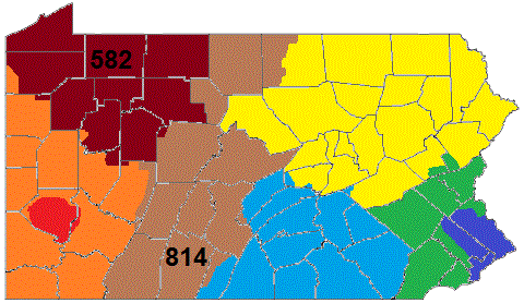
Area codes 814 and 582 are telephone area codes in the North American Numbering Plan (NANP) for the northwestern and central portions of the Commonwealth of Pennsylvania. Cities served by the area code include Altoona, Bradford, DuBois, Erie, Meadville, Oil City, Titusville, Johnstown, St. Marys, and Warren as well as the boroughs of State College, Brockway, Clearfield, Huntingdon, Mount Union, Bedford, Clarion, Punxsutawney, Tyrone, Ebensburg, Coudersport, Ridgway and Brookville. Area code 814 is the original area code assigned to the numbering plan area in 1947 and area code 582 was activated in the service area as an additional code to form an overlay plan with a starting date of October 3, 2020. History Area code 814 is one of the original North American area codes established in 1947. Its numbering plan area (NPA) is the largest in the state. It is the only one of Pennsylvania's original four NPAs that still has its original boundaries. The largest cities in the ... [...More Info...] [...Related Items...] OR: [Wikipedia] [Google] [Baidu] |
Area Code
A telephone numbering plan is a type of numbering scheme used in telecommunication to assign telephone numbers to subscriber telephones or other telephony endpoints. Telephone numbers are the addresses of participants in a telephone network, reachable by a system of destination code routing. Telephone numbering plans are defined in each of the administrative regions of the public switched telephone network (PSTN) and in private telephone networks. For public numbering systems, geographic location typically plays a role in the sequence of numbers assigned to each telephone subscriber. Many numbering plan administrators subdivide their territory of service into geographic regions designated by a prefix, often called an area code or city code, which is a set of digits forming the most-significant part of the dialing sequence to reach a telephone subscriber. Numbering plans may follow a variety of design strategies which have often arisen from the historical evolution of individual ... [...More Info...] [...Related Items...] OR: [Wikipedia] [Google] [Baidu] |
Huntingdon, Pennsylvania
Huntingdon is a borough in (and the county seat of) Huntingdon County, Pennsylvania, Huntingdon County, Pennsylvania, United States. It is located along the Juniata River, approximately east of Altoona, Pennsylvania, Altoona and west of Harrisburg, Pennsylvania, Harrisburg. With a population of 7,093 at the 2010 United States Census, 2010 census, it is the largest population center near Raystown Lake, a winding, flood-control reservoir managed by the U. S. Army Corps of Engineers, U.S. Army Corps of Engineers. The borough is located on the main line of the Norfolk Southern Railway, Norfolk Southern (formerly Pennsylvania) Railway, in an agricultural and outdoor recreational region with extensive forests and scattered deposits of Ganister, ganister rock, coal, fire clay, and limestone. Historically, the region surrounding Huntingdon was dotted with iron furnaces and forges, consuming limestone, iron ore and wood (for charcoal production) throughout the 19th century. Dairy farms ... [...More Info...] [...Related Items...] OR: [Wikipedia] [Google] [Baidu] |
Permissive Dialing
In North America, permissive dialing is the ability to make phone calls in an area subject to a newly introduced area code by using both the new and preexisting dialing methods. When an area is given a new area code under a split plan, the area's previous area code would no longer be valid for calls in the area, so calls to numbers using the old area code will not work. To alleviate misdialing frustration, the local routing can be set up such that both the old and new area codes will work for the same telephone exchange. During this period, the local numbering authority must not reassign the area's existing exchanges to the remaining area of the old area code, nor vice versa. At the end of the permissive dialing period, the old area code is no longer valid for numbers in the affected area. Under an overlay plan, permissive dialing refers to the ability to continue to connect calls via 7-digit dialing while also making 10-digit dialing valid. Again, the affected area must not intr ... [...More Info...] [...Related Items...] OR: [Wikipedia] [Google] [Baidu] |
Pennsylvania Public Utility Commission
Pennsylvania Public Utility Commission (PUC) is the public utility commission in Pennsylvania. It is composed of five commissioners, appointed by the Governor with the consent of the state Senate. The PUC oversees public utility and services operations in the commonwealth, in sectors including water, energy, telecommunications, and transportation. State code requires separation of the five commissioners and an investigatory division. History The Pennsylvania Public Utility Commission has roots in the founding of the Pennsylvania State Railroad Commission in 1907. The railroad commission was replaced in 1913 with the Pennsylvania Public Service Commission (PSC). Act 43 of 1937 replaced the Public Service Commission with the Public Utility Commission, with a charter to oversee and regulate all public utilities doing business in the Commonwealth. The PUC provided standards for metering of small alternative energy suppliers, such as solar and biodigesters, in June 2006. The standa ... [...More Info...] [...Related Items...] OR: [Wikipedia] [Google] [Baidu] |
Original North American Area Codes
The original North American area codes were established by the American Telephone & Telegraph Company (AT&T) in 1947, following the demonstration of regional Operator Toll Dialing during the World War II period. The program had the goal of speeding the connecting times for long-distance calling by eliminating intermediary telephone operators. Expanding this technology for national use required a comprehensive and universal, continent-wide telephone numbering plan. The new numbering plan established a uniform destination addressing and call routing system for all telephone networks in North America which had become an essential public service. It had the eventual benefit of direct distance dialing (DDD) by telephone subscribers. The initial ''Nationwide Numbering Plan'' of 1947 established eighty-six numbering plan areas (NPAs) that principally followed existing U.S. state and Canadian provincial boundaries, but fifteen states and provinces were subdivided further. Forty NPAs wer ... [...More Info...] [...Related Items...] OR: [Wikipedia] [Google] [Baidu] |
Overlay Plan
Overlay may refer to: Computers *Overlay network, a computer network which is built on top of another network *Hardware overlay, one type of video overlay that uses memory dedicated to the application *Another term for exec, replacing one process by another *Overlay (programming), a technique to reduce the amount of memory used by a program *Overlay keyboard, a specialized keyboard with no pre-set keys * Keyboard overlay, a sheet of printed text sitting between the keys, depicting an alternate keyboard layout *Vector overlay, an analysis procedure in a geographic information system for integrating multiple data sets Other uses *Overlay architecture, temporary elements that supplement existing buildings and infrastructure for major sporting events or festivals *Overlay control, in semiconductor manufacturing, for monitoring layer-to-layer alignment on multi-layer device structures *Overlay plan, a method of introducing new area codes in telephony *Historic overlay district, a zonin ... [...More Info...] [...Related Items...] OR: [Wikipedia] [Google] [Baidu] |
Brookville, Pennsylvania
Brookville is a Borough (Pennsylvania), borough in Jefferson County, Pennsylvania, Jefferson County in the U.S. state of Pennsylvania, northeast of Pittsburgh. As of the 2010 United States census, 2010 census, the population was 3,933. Founded in 1830, it is the county seat of Jefferson County History The area was initially settled in the late 1790s upon the arrival of brothers Joseph and Andrew Barnett, as well as their brother-in-law Samuel Scott, who together established the first settlement at the confluence of the Sandy Lick and Mill Creeks in the area now known as Port Barnett, Pennsylvania, Port Barnett. The first non-Native American settler of the land within the eventual town limits was Moses Knapp, who built a log house at the confluence of North Fork Creek and Sandy Lick Creek (which form Redbank Creek (Pennsylvania), Redbank Creek) in 1801. The 105th Pennsylvania Infantry Regiment, also known as the Wildcat Regiment, was a volunteer infantry regiment that served in th ... [...More Info...] [...Related Items...] OR: [Wikipedia] [Google] [Baidu] |
Ridgway, Pennsylvania
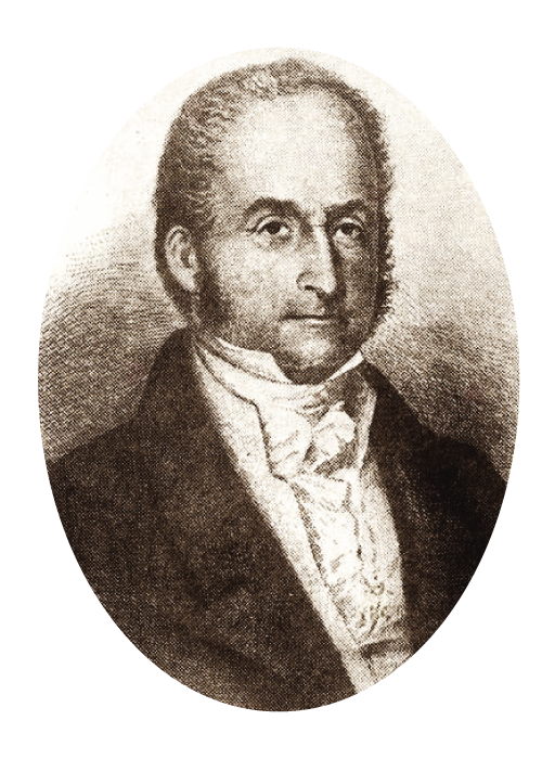
Ridgway is a borough in and the county seat of Elk County, Pennsylvania. As of the 2010 census it had a population of 4,078. History Ridgway was founded by Philadelphian shipping merchant Jacob Ridgway and James Gillis. Jacob Ridgway earned substantial wealth both in Philadelphia and abroad in London. He constantly sent sums of money back to be invested in property. In the early 19th century as part of a larger land purchase, Ridgway acquired that became Elk County. One of Jacob Ridgway's nephews, James Gillis, convinced Ridgway that the area could become a very lucrative spot for a lumber camp due to the proximity of Elk Creek and the Clarion River, a tributary of the Allegheny River. Coal and natural gas abound in the district. In the past, the industrial interests were manufacturing leather, iron, clay, and lumber products, silk goods, railroad snow plows, dynamos, and machine tools. In 1900, the people living here numbered 3,515; in 1910, 5,408; in 1940, 6,253, and in 2010, ... [...More Info...] [...Related Items...] OR: [Wikipedia] [Google] [Baidu] |
Coudersport, Pennsylvania
Coudersport is a borough in and the county seat of Potter County, Pennsylvania. It is located approximately east by south of Erie on the Allegheny River. The population was 2,371 at the 2020 census. History The Coudersport and Port Allegany Railroad Station, Coudersport Historic District, and Potter County Courthouse are listed on the National Register of Historic Places. Geography Coudersport is located at (41.773903, -78.018559). According to the U.S. Census Bureau, the borough has a total area of , all land. Coudersport lies in a broad valley at the confluence of the Allegheny River and Mill Creek. It is surrounded by the great hilltop plateaux of the Allegheny highlands. Highways enter north and south on Pennsylvania Route 44, the very old Jersey Shore (log road) Turnpike, and from west to east on U.S. Route 6, the "Grand Army of the Republic Highway", which had been long a major mid-east-states east-west corridor before the construction of Interstate highways which began ... [...More Info...] [...Related Items...] OR: [Wikipedia] [Google] [Baidu] |
Ebensburg, Pennsylvania
Ebensburg is a borough and the county seat of Cambria County in the U.S. state of Pennsylvania. It is located west of Altoona and surrounded by Cambria Township. It is situated in the Allegheny Mountains at about above sea level. Ebensburg is located in a rich bituminous coal region. In the past, sawmills, tanneries, wool mills, and a foundry operated there. The number of residents in 1900 was 1,574, and in 1910, 1,978. The population was 3,351 at the 2010 census. It is part of the Johnstown, Pennsylvania Metropolitan Statistical Area. Ending in Ebensburg is the Ghost Town Trail, a rail trail established in 1991 on the right-of-way of the former Ebensburg and Black Lick Railroad. Also of note, next to the old Cambria County Jail, is the Veterans Park of Cambria County honoring the men from Cambria County who fought in the Revolutionary War, War of 1812, Mexican-American War, Civil War, and the Spanish-American War. History Ebensburg originated in November 1796, when Congreg ... [...More Info...] [...Related Items...] OR: [Wikipedia] [Google] [Baidu] |
Tyrone, Pennsylvania
Tyrone is a borough in Blair County, Pennsylvania, northeast of Altoona, on the Little Juniata River. Tyrone was of considerable commercial importance in the twentieth century. It was an outlet for the Clearfield coal fields and was noted for manufacturing paper products. There were planing mills and chemical and candy factories. In 1900, 5,847 people lived here; in 1910, 7,176; and in 1940, 8,845 people resided here. The population was 5,477 at the 2010 census. It is part of the Altoona, PA Metropolitan Statistical Area. It was named after County Tyrone in Ireland. Located along the main lines of the Norfolk Southern and Nittany and Bald Eagle railroads, and U.S. Route 220, Pennsylvania Route 453, and Interstate 99 highways, Tyrone was at one time known as "The Hub of the Highways". In those days, four railroads ennsylvania, Tyrone and Clearfield, Tyrone and Lock Haven, Lewisburg, and Tyroneand three main highways S-220, PA-350, PA-453converged there. History The Tyrone ... [...More Info...] [...Related Items...] OR: [Wikipedia] [Google] [Baidu] |
Punxsutawney, Pennsylvania
Punxsutawney (; Unami language, Lenape: ' ) is a Borough (Pennsylvania), borough in southern Jefferson County, Pennsylvania. Punxsutawney is known globally for its annual Groundhog Day celebration held each February 2, during which thousands of attendees and international media outlets visit the town for an annual weather prediction by the groundhog Punxsutawney Phil, though the actual prediction location, Gobbler's Knob, is actually in adjacent Young Township, Jefferson County, Pennsylvania, Young Township. The borough, located northeast of Pittsburgh and northwest of Altoona, Pennsylvania, Altoona, was incorporated in 1850. With a population of 5,962 as of the 2010 census, Punxsutawney is the largest incorporated municipality in Jefferson County. History Shawnee wigwam villages once occupied this site on the Mahoning Creek. The first settlement that included non-indigenous people was in 1772, when Reverend John Ettwein, a Moravian Church missionary, arrived with a band of 24 ... [...More Info...] [...Related Items...] OR: [Wikipedia] [Google] [Baidu] |


