|
Area Code 857
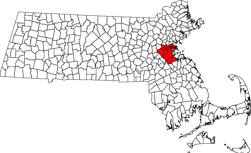
Area codes 617 and 857 are the North American area codes serving Boston and several surrounding communities in Massachusetts—such as Brookline, Cambridge, Newton and Quincy ( LATA code 128). The main area code, 617, was one of the original area codes from October 1947, and originally covered the eastern two-thirds of Massachusetts, from roughly the western end of Worcester County to Cape Cod and the South Coast. The rest of the state was served by area code 413; Massachusetts was the only New England state split between multiple area codes at the outset. In July 1988, most of the western, northern and southern portions of the old 617 territory, including Worcester County, the Merrimack Valley, the South Coast, and the Cape and Islands, were split off as area code 508. Permissive dialing of 617 continued across eastern Massachusetts until January 1, 1989. In 1997, the northern, western and southern portions of the new 617 split off as 781, which almost completely surro ... [...More Info...] [...Related Items...] OR: [Wikipedia] [Google] [Baidu] |
Cape And Islands
Cape Cod is a peninsula extending into the Atlantic Ocean from the southeastern corner of mainland Massachusetts, in the northeastern United States. Its historic, maritime character and ample beaches attract heavy tourism during the summer months. The name Cape Cod, coined in 1602 by Bartholomew Gosnold, is the ninth oldest English place-name in the U.S. As defined by the Cape Cod Commission's enabling legislation, Cape Cod is conterminous with Barnstable County, Massachusetts. It extends from Provincetown in the northeast to Woods Hole in the southwest, and is bordered by Plymouth to the northwest. The Cape is divided into fifteen towns, several of which are in turn made up of multiple named villages. Cape Cod forms the southern boundary of the Gulf of Maine, which extends north-eastward to Nova Scotia. Since 1914, most of Cape Cod has been separated from the mainland by the Cape Cod Canal. The canal cuts roughly across the base of the peninsula, though small portions of the ... [...More Info...] [...Related Items...] OR: [Wikipedia] [Google] [Baidu] |
Essex County, Massachusetts
Essex County is a County (United States), county in the northeastern part of the U.S. state of Massachusetts. At the 2020 United States Census, 2020 census, the total population was 809,829, making it the third-most populous county in the state, and the List of the most populous counties in the United States, eightieth-most populous in the country. It is part of the Greater Boston area (the Boston–Cambridge, Massachusetts, Cambridge–Newton, Massachusetts, Newton, MA–New Hampshire, NH Metropolitan Statistical Area). The largest city in Essex County is Lynn, Massachusetts, Lynn. The county was named after the England, English county of Essex. It has two traditional county seats: Salem, Massachusetts, Salem and Lawrence, Massachusetts, Lawrence. Prior to the dissolution of the county government in 1999, Salem had jurisdiction over the Southern Essex District, and Lawrence had jurisdiction over the Northern Essex District, but currently these cities do not function as seats of ... [...More Info...] [...Related Items...] OR: [Wikipedia] [Google] [Baidu] |
Winthrop, Massachusetts
Winthrop is a town in Suffolk County, Massachusetts, Suffolk County, Massachusetts, United States. The population was 19,316 at the 2020 United States Census, 2020 census. Winthrop is an ocean-side suburban community in Greater Boston situated at the north entrance to Boston Harbor, close to Logan International Airport. It is located on a peninsula, 1.6 square miles (4.2 km2) in area, connected to Revere, Massachusetts, Revere by a narrow isthmus and to East Boston, Massachusetts, East Boston by a bridge over the harbor inlet to the Belle Isle Marsh Reservation. Settled in 1630, Winthrop is one of the oldest communities in the United States. It is also one of the smallest and most densely populated municipalities in Massachusetts. It is one of the four cities that compose Suffolk County (the others are Boston, Revere, Massachusetts, Revere, and Chelsea, Massachusetts, Chelsea). It is the southernmost part of the North Shore (Massachusetts), North Shore, with a shoreline tha ... [...More Info...] [...Related Items...] OR: [Wikipedia] [Google] [Baidu] |
Watertown, Massachusetts
Watertown is a city in Middlesex County, Massachusetts, and is part of Greater Boston. The population was 35,329 in the 2020 census. Its neighborhoods include Bemis, Coolidge Square, East Watertown, Watertown Square, and the West End. Watertown was one of the first Massachusetts Bay Colony settlements organized by Puritans, Puritan settlers in 1630. The city is home to the Perkins School for the Blind, the Armenian Library and Museum of America, and the historic Watertown Arsenal, which produced military armaments from 1816 through World War II. History Archeological evidence suggests that Watertown was inhabited for thousands of years before European colonization of the Americas, colonization. In the 1600s, two groups of Massachusett, the Pequossette and the Nonantum, had settlements on the banks of the river later called the Charles, and a contemporary source lists "Pigsgusset" as the native name of "Water towne." The Pequossette built a fishing weir to trap herring at the ... [...More Info...] [...Related Items...] OR: [Wikipedia] [Google] [Baidu] |
Somerville, Massachusetts
Somerville ( ) is a city located directly to the northwest of Boston, and north of Cambridge, Massachusetts, Cambridge, in Middlesex County, Massachusetts, United States. As of the 2020 United States Census, the city had a total population of 81,045 people. With an area of , the city has a density of , making it the most densely populated municipality in New England and the List of United States cities by population density, 16th most densely populated incorporated municipality in the country. Somerville was established as a town in 1842, when it was separated from Charlestown, Massachusetts, Charlestown. In 2006, the city was named the best-run city in Massachusetts by ''The Boston Globe''. In 1972, 2009, and 2015, the city received the All-America City Award. It is home to Tufts University, which has its campus along the Somerville and Medford, Massachusetts, Medford border. History Early settlement The territory now comprising the city of Somerville was first settled by Euro ... [...More Info...] [...Related Items...] OR: [Wikipedia] [Google] [Baidu] |
Milton, Massachusetts
Milton is a town in Norfolk County, Massachusetts, United States and an affluent suburb of Boston. The population was 28,630 at the 2020 census. Milton is the birthplace of former U.S. President George H. W. Bush, and architect Buckminster Fuller. Milton was ranked by Money as the 2nd, 7th, 8th, and 17th best place to live in the United States in 2011, 2009, 2019, 2021, and 2022 respectively. Milton is located in the relatively hilly area between the Neponset River and Blue Hills, bounded by Brush Hill to the west, Milton Hill to the east, Blue Hills to the south and the Neponset River to the north. It is also bordered by Boston's Dorchester and Mattapan neighborhoods to the north and its Hyde Park neighborhood to the west; Quincy to the southeast; Randolph to the south, and Canton to the west. History Indigenous peoples The area now known as Milton was inhabited for tens of thousands of years prior to European colonization. The Paleoamerican archaeological site Fowl Mead ... [...More Info...] [...Related Items...] OR: [Wikipedia] [Google] [Baidu] |
Everett, Massachusetts
Everett is a city in Middlesex County, Massachusetts, United States, directly north of Boston, bordering the neighborhood of Charlestown. The population was 49,075 at the time of the 2020 United States Census. Everett was the last city in the United States to have a bicameral legislature, which was composed of a seven-member Board of Aldermen and an eighteen-member Common Council. On November 8, 2011, the voters approved a new City Charter that changed the City Council to a unicameral body with eleven members – six ward councilors and five councilors-at-large. The new City Council was elected during the 2013 City Election. History and Transportation Everett was originally part of Charlestown, and later Malden. It separated from Malden in 1870. In 1892, Everett changed from a town to a city. On December 13, 1892, Alonzo H. Evans defeated George E. Smith to become Everett's first Mayor. Landfill has expanded the Everett shoreline over the centuries. At some point between 19 ... [...More Info...] [...Related Items...] OR: [Wikipedia] [Google] [Baidu] |
Chelsea, Massachusetts
Chelsea is a city in Suffolk County, Massachusetts, Suffolk County, Massachusetts, United States, directly across the Mystic River from the city of Boston. As of the 2020 census, Chelsea had a population of 40,787. With a total area of just 2.46 square miles, Chelsea is the smallest city in Massachusetts in terms of total area. It is the List of United States cities by population density, second most densely populated city in Massachusetts, behind Somerville, Massachusetts, Somerville, and is the city with the Hispanics and Latinos in Massachusetts, second-highest percentage of Latino residents in Massachusetts, behind Lawrence, Massachusetts, Lawrence. History The area of Chelsea was first called ''Winnisimmet'' possibly meaning "good spring nearby" or "swamp hill" by the Naumkeag people, Naumkeag tribe, who lived there for thousands of years prior to European colonization in the 1600s. Samuel Maverick (colonist), Samuel Maverick became the first European to settle permanently ... [...More Info...] [...Related Items...] OR: [Wikipedia] [Google] [Baidu] |
Belmont, Massachusetts
Belmont is a town in Middlesex County, Massachusetts. It is a western suburb of Boston, Massachusetts, United States; and is part of the Greater Boston metropolitan area. At the time of the 2020 U.S. Census, the town's population stood at 27,295, up 10.4% from 2010. History Belmont was established on March 10, 1849, by former citizens of, and land from the bordering towns of Watertown, to the south; Waltham, to the west; and Arlington, then known as West Cambridge, to the north. They also wanted a town where no one could buy or sell alcohol (alcohol is now legal to purchase in Belmont). The town was named after ''Bellmont'', the 200 acre (0.8 km2) estate of the largest donor to its creation, John Perkins Cushing. Cushing Square is named after him and what was left of his estate after it nearly burned to the ground became a Belmont Public Library branch. The easternmost section of the town, including the western portion of Fresh Pond, was annexed by Cambridge in 1880 in ... [...More Info...] [...Related Items...] OR: [Wikipedia] [Google] [Baidu] |
Area Code 978
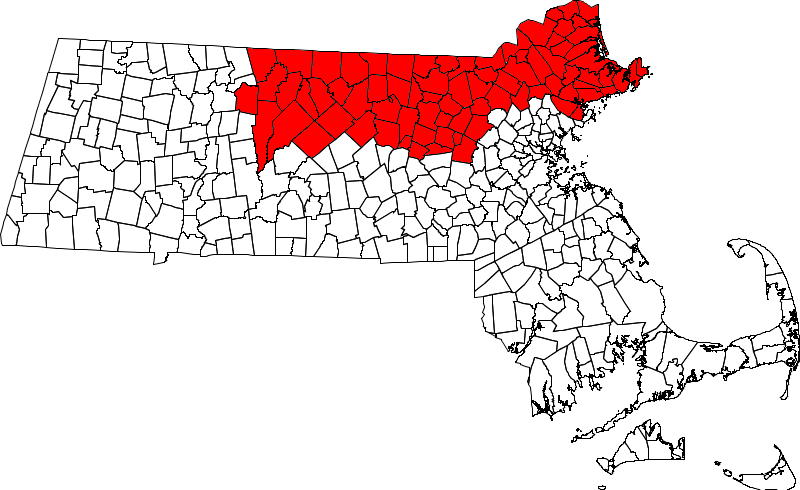
Area code 978 was created as a split from area code 508 on September 1, 1997, and covers north central and most of northeastern Massachusetts ( LATA code 128). Use of 978 became mandatory on February 1, 1998. Prior to when this area was served by 508 (July 1988), it was served only by the 617 area code, along with the rest of the eastern two-thirds of the state. 351 has been sharing the service area since May 2, 2001. Since then, 10 digit local dialing is mandatory. Some mobile phone numbers from the 1990s assigned to rate centers in 978 and 351 kept the 508 area code just on those mobile lines after it was split. Cities/towns * Acton * Ashburnham * Ashby * Andover * Amesbury * Ayer * Berlin * Beverly * Billerica * Bolton * Boxborough * Burlington * Carlisle * Chelmsford * Clinton * Concord * Danvers * Dracut * Dunstable * Fitchburg * Gardner * Georgetown * Gloucester * Groton * Groveland * Harvard * Haverhill * Hudson * Ipswich * Lancaster * Lawrence * Leominst ... [...More Info...] [...Related Items...] OR: [Wikipedia] [Google] [Baidu] |
Area Code 508
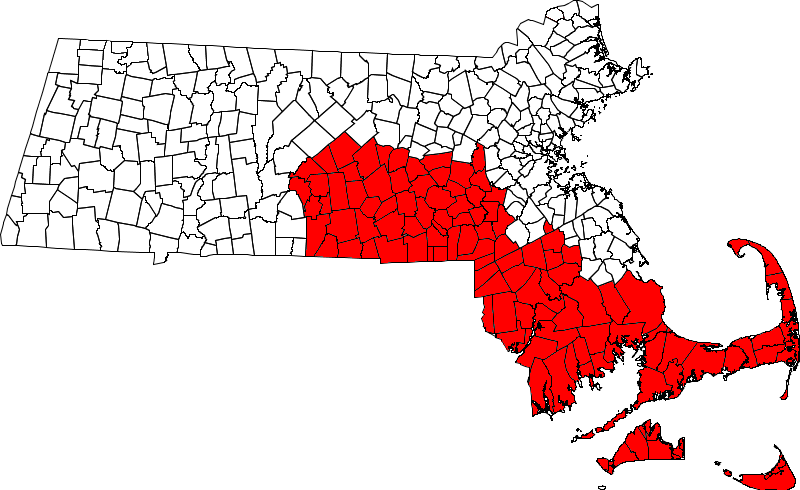
Area codes 508 and 774 are telephone area codes in the North American Numbering Plan (NANP) for the U.S. state of Massachusetts. The numbering plan area comprises south-central and most of southeastern Massachusetts ( LATA code 128). It includes Worcester, Outer south and southwest Greater Boston (such as the MetroWest region), as well as Fall River, New Bedford, Cape Cod, Martha's Vineyard, and Nantucket. History Massachusetts was originally divided into two numbering plan areas, when AT&T initiated the development of the North American Numbering Plan in 1947. Area code 617 was assigned to the eastern two-thirds of Massachusetts from roughly the western end of Worcester County to Boston, The Cape and Islands, and the South Coast, while the western part received area code 413. Area code 508 was created on July 16, 1988, in a split from 617, with a semicircle around Boston retaining 617 and the northern, western, and southern parts of the area becoming 508. Permissive dialin ... [...More Info...] [...Related Items...] OR: [Wikipedia] [Google] [Baidu] |


