|
António De Saldanha
António de Saldanha was a Castilian-Portuguese 16th-century captain. He was the first European to set anchor in what is now called Table Bay, South Africa, and made the first recorded ascent of Table Mountain.Mary Gunn, L. e. Codd, L. E. W. Codd. ''Botanical Exploration of Southern Africa: An Illustrated History of Early Botanical Literature on the Cape Flora : Biographical Accounts of the Leading Plant Collectors and Their Activities in Southern Africa from the Days of the East India Company Until Modern Times.'' CRC Press, 1981. p5-7. Background Chroniclers Gaspar Correia (p. 412) and Fernão Lopes de Castanheda (p. 157) identify António de Saldanha as a " Castilian nobleman" who arrived in Portugal around 1497, in the household service of the queen Maria of Aragon. His original Castilian name is unknown, 'Saldanha' possibly referring to the Castilian town of Saldaña, which may have been his place of origin. Expedition of 1503 Being a man of "some nauti ... [...More Info...] [...Related Items...] OR: [Wikipedia] [Google] [Baidu] |
Crown Of Castile
The Crown of Castile was a medieval polity in the Iberian Peninsula that formed in 1230 as a result of the third and definitive union of the crowns and, some decades later, the parliaments of the kingdoms of Castile and León upon the accession of the then Castilian king, Ferdinand III, to the vacant Leonese throne. It continued to exist as a separate entity after the personal union in 1469 of the crowns of Castile and Aragon with the marriage of the Catholic Monarchs up to the promulgation of the Nueva Planta decrees by Philip V in 1715. In 1492, the voyage of Christopher Columbus and the discovery of the Americas were major events in the history of Castile. The West Indies, Islands and Mainland of the Ocean Sea were also a part of the Crown of Castile when transformed from lordships to kingdoms of the heirs of Castile in 1506, with the Treaty of Villafáfila, and upon the death of Ferdinand the Catholic. The discovery of the Pacific Ocean, the Conquest of the Aztec Empir ... [...More Info...] [...Related Items...] OR: [Wikipedia] [Google] [Baidu] |
São Tomé And Príncipe
São Tomé and Príncipe (; pt, São Tomé e Príncipe (); English: " Saint Thomas and Prince"), officially the Democratic Republic of São Tomé and Príncipe ( pt, República Democrática de São Tomé e Príncipe), is a Portuguese-speaking island country in the Gulf of Guinea, off the western equatorial coast of Central Africa. It consists of two archipelagos around the two main islands of São Tomé and Príncipe, about apart and about off the north-western coast of Gabon. With a population of 201,800 (2018 official estimate),Instituto Nacional de Estadística de São Tomé e Príncipe, as at 13 May 2018. São Tomé and Príncipe is the second-smallest and second-least populous African sovereign state after Seychelles. The islands were uninhabited until their discovery by Portuguese explorers in the 15th century. Gradually colonized and settled throughout the 16th century, they collectively served as a vital commercial and trade centre for the Atlantic slave trade. The ri ... [...More Info...] [...Related Items...] OR: [Wikipedia] [Google] [Baidu] |
Zanzibar
Zanzibar (; ; ) is an insular semi-autonomous province which united with Tanganyika in 1964 to form the United Republic of Tanzania. It is an archipelago in the Indian Ocean, off the coast of the mainland, and consists of many small islands and two large ones: Unguja (the main island, referred to informally as Zanzibar) and Pemba Island. The capital is Zanzibar City, located on the island of Unguja. Its historic centre, Stone Town, is a World Heritage Site. Zanzibar's main industries are spices, raffia and tourism. In particular, the islands produce cloves, nutmeg, cinnamon, and black pepper. For this reason, the Zanzibar Archipelago, together with Tanzania's Mafia Island, are sometimes referred to locally as the "Spice Islands". Tourism in Zanzibar is a more recent activity, driven by government promotion that caused an increase from 19,000 tourists in 1985, to 376,000 in 2016. The islands are accessible via 5 ports and the Abeid Amani Karume International Airport, w ... [...More Info...] [...Related Items...] OR: [Wikipedia] [Google] [Baidu] |
Kilwa Kisiwani
Kilwa Kisiwani (English: ''Kilwa Island'') is an island, national historic site, and hamlet community located in the township of Kilwa Masoko, the district seat of Kilwa District in the Tanzanian region of Lindi Region in southern Tanzania. Kilwa Kisiwani is the largest of the nine hamlets in the town Kilwa Masoko and is also the least populated hamlet in the township with less than 1,000 residents. At its peak Kilwa hosted over 10,000 inhabitants in the Middle Ages. Since 1981 the entire island of Kilwa Kisiwani has been designated by UNESCO as a World Heritage Site along with the nearby ruins of Songo Mnara. Despite its significant historic reputation, Kilwa Kisiwani is still home to a small and resilient community of native residents that have inhabited the island for centuries. Kilwa Kisiwani is one of the seven World Heritage Sites located in Tanzania. Additionally, the site is a registered National Historic Site. Geography Kilwa Kisiwani Island lies exactly at 9 degr ... [...More Info...] [...Related Items...] OR: [Wikipedia] [Google] [Baidu] |
Mozambique Island
The Island of Mozambique ( pt, Ilha de Moçambique) lies off northern Mozambique, between the Mozambique Channel and Mossuril Bay, and is part of Nampula Province. Prior to 1898, it was the capital of colonial Portuguese East Africa. With its rich history and sandy beaches, the Island of Mozambique is a UNESCO World Heritage site and one of Mozambique's fastest-growing tourist destinations. It has a permanent population of approximately 14,000 people and is served by nearby Lumbo Airport on the Nampula mainland. The name of the country, Mozambique, is derived from the name of this island. History Pottery found on Mozambique Island indicates that the town was founded no later than the fourteenth century. According to tradition, the original Swahili population came from Kilwa. The town's rulers had links with the rulers of both Angoche and Quelimane by the fifteenth century. In 1514, Duarte Barbosa noted that the town had a Muslim population and that they spoke the same Swahili dia ... [...More Info...] [...Related Items...] OR: [Wikipedia] [Google] [Baidu] |
Mossel Bay
Mossel Bay ( af, Mosselbaai) is a harbour town of about 99,000 people on the Southern Cape (or Garden Route) of South Africa. It is an important tourism and farming region of the Western Cape Province. Mossel Bay lies 400 kilometres east of the country's seat of parliament, Cape Town (which is also the capital city of the Western Cape), and 400 km west of Port Elizabeth, the largest city in the Eastern Cape. The older parts of the town occupy the north-facing side of the Cape St Blaize Peninsula, whilst the newer suburbs straddle the Peninsula and have spread eastwards along the sandy shore of the Bay. The town's economy relied heavily on farming, fishing and its commercial harbour (the smallest in the Transnet Port Authority's stable of South African commercial harbours), until the 1969 discovery of natural offshore gas fields led to the development of the gas-to-liquids refinery operated by PetroSA. Tourism is another driver of Mossel Bay's economy. Etymology The origi ... [...More Info...] [...Related Items...] OR: [Wikipedia] [Google] [Baidu] |
Saldanha Bay
Saldanha Bay ( af, Saldanhabaai) is a natural harbour on the south-western coast of South Africa. The town that developed on the northern shore of the bay, also called Saldanha, was incorporated with five other towns into the Saldanha Bay Local Municipality in 2000. The current population of the municipality is estimated at 72,000. The place is mentioned in the first edition of John Locke's ''Two Treatises of Government'' as an example of the state of nature.''Second Treatise'', sec. 14. Locke replaced the reference to "Soldania" with a story told by Garcilaso de la Vega about a desert island in subsequent editions (Peter Laslett, ed., ''Two Treatises of Government'', by John Locke, student edition ew York: Cambridge University Press, 1988 277n). Saldanha Bay's location makes it a paradise for the watersport enthusiast, and its local economy being strongly dependent on fishing, mussels, seafood processing, the steel industry and the harbour. Furthermore, its sheltered harbour pl ... [...More Info...] [...Related Items...] OR: [Wikipedia] [Google] [Baidu] |
Joris Van Spilbergen
Joris van Spilbergen (1568 in Antwerp – January 31, 1620 in Bergen op Zoom) was a Dutch naval officer. Joris van Spilbergen was born in Antwerp in 1568. His first major expedition was in 1596, when he sailed to Africa. He then left for Asia on 5 May 1601, from Veere, a seaport on the island of Walcheren in Zealand, in command of the fleet of the company of Balthazar de Moucheron (a trading company before the establishment of the VOC). His ships were the ''Ram'', ''Schaap'', and ''Lam''. Spilbergen met the king of Kandy (Sri Lanka) Vimala Dharma Suriya in 1602, and discussed the possibility of trade in cinnamon. In 1607, Spilbergen, onboard ''Aeolus'', was with Jacob van Heemskerk at the Battle of Gibraltar. In 1614, he sailed beyond the Strait of Magellan with an expedition of five ships. Despite the fact that the Twelve Years' Truce between Spain and the Dutch Republic was in force, he raided the Spanish settlements on the coast of Mexico and South America. He foug ... [...More Info...] [...Related Items...] OR: [Wikipedia] [Google] [Baidu] |
Cartographer
Cartography (; from grc, χάρτης , "papyrus, sheet of paper, map"; and , "write") is the study and practice of making and using maps. Combining science, aesthetics and technique, cartography builds on the premise that reality (or an imagined reality) can be modeled in ways that communicate spatial information effectively. The fundamental objectives of traditional cartography are to: * Set the map's agenda and select traits of the object to be mapped. This is the concern of map editing. Traits may be physical, such as roads or land masses, or may be abstract, such as Toponomy, toponyms or political boundaries. * Represent the terrain of the mapped object on flat media. This is the concern of map projections. * Eliminate characteristics of the mapped object that are not relevant to the map's purpose. This is the concern of Cartographic generalization, generalization. * Reduce the complexity of the characteristics that will be mapped. This is also the concern of generaliza ... [...More Info...] [...Related Items...] OR: [Wikipedia] [Google] [Baidu] |
Khoikhoi
Khoekhoen (singular Khoekhoe) (or Khoikhoi in the former orthography; formerly also ''Hottentot (racial term), Hottentots''"Hottentot, n. and adj." ''OED Online'', Oxford University Press, March 2018, www.oed.com/view/Entry/88829. Accessed 13 May 2018. Citing G. S. Nienaber, 'The origin of the name “Hottentot” ', ''African Studies'', 22:2 (1963), 65-90, . See also . ) are the traditionally Nomad, nomadic pastoralist Indigenous peoples of Africa, indigenous population of southwestern Africa. They are often grouped with the hunter-gatherer San people, San (literally "Foragers") peoples. The designation "Khoekhoe" is actually a ''kare'' or praise address, not an ethnic endonym, but it has been used in the literature as an ethnic term for Khoe–Kwadi languages, Khoe-speaking peoples of Southern Africa, particularly pastoralist groups, such as the Griqua people, !Ora, !Gona, Nama people, Nama, Khoemana, Xiri and Damara people, ǂNūkhoe nations. While the presence of Kho ... [...More Info...] [...Related Items...] OR: [Wikipedia] [Google] [Baidu] |
Lion's Head (Cape Town)
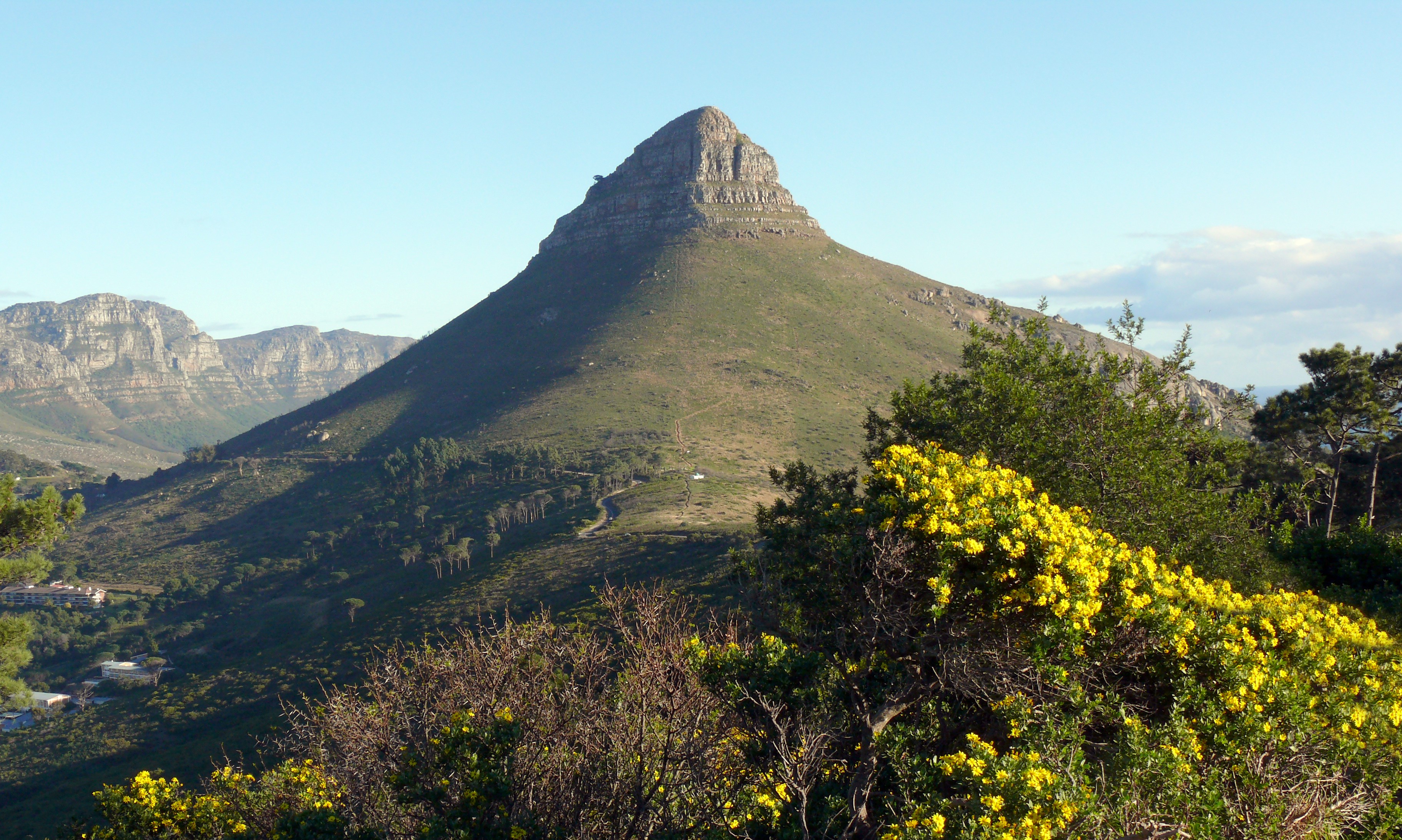
Lion's Head is a mountain in Cape Town, South Africa, between Table Mountain and Signal Hill. Lion's Head peaks at above sea level. The peak forms part of a dramatic backdrop to the city of Cape Town and is part of the Table Mountain National Park. Surrounding The suburbs of the city surround the peak and Signal Hill on almost all sides, but strict management by city authorities has kept development of housing off the higher ground. The area is significant to the Cape Malay community, who historically lived in the Bo-Kaap quarter close to Lion's Head. There are a number of historic graves and shrines (''kramat''s) of Malay leaders on the lower slopes and on Signal Hill. History In the 17th century the peak was known as ''Leeuwen Kop'' (Lion's Head) by the Dutch, and Signal Hill was known as ''Leeuwen Staart'' (Lion's Tail), as the shape resembles a crouching lion or a sphinx. The English in the 17th Century called the peak Sugar Loaf. In 1897 gold was discovered on Lion' ... [...More Info...] [...Related Items...] OR: [Wikipedia] [Google] [Baidu] |
Cape Point
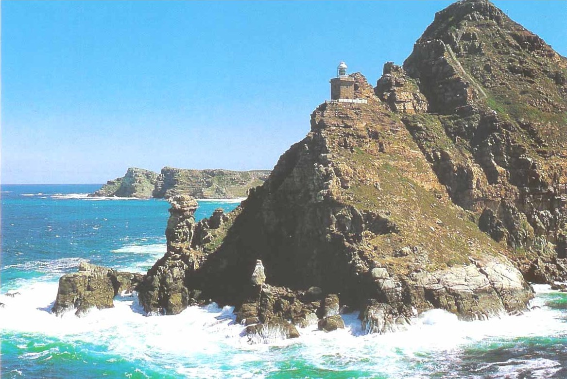
Cape Point ( af, Kaappunt) is a promontory at the southeast corner of the Cape Peninsula, a mountainous and scenic landform that runs north-south for about thirty kilometres at the extreme southwestern tip of the African continent in South Africa. Table Mountain and the city of Cape Town are close to the northern extremity of the same peninsula. The cape is located at , about 2.3 kilometres (1.4 mi) east and a little north of the Cape of Good Hope on the southwest corner. Although these two rocky capes are very well known, neither cape is actually the southernmost point of the mainland of Africa; that is Cape Agulhas, approximately to the east-southeast. Peaks The peak above Cape Point is higher than that above the Cape of Good Hope. The rugged sandstone (Table Mountain sandstone) ridge that rises from Cape Point at sea level develops into two peaks. There is a major peak that dominates the skyline locally, but there is also a smaller peak about 100 m (328 ft) furthe ... [...More Info...] [...Related Items...] OR: [Wikipedia] [Google] [Baidu] |


