|
Ann Carroll Fitzhugh
Ann Carroll Smith ( Fitzhugh; 1805–1875)Syracuse University, Smith FamilTree was an American abolitionist, mother of Elizabeth Smith Miller, and the spouse of Gerrit Smith. Her older brother was Henry Fitzhugh. Ann and Gerrit Smith's Peterboro, New York, home was a station on the Underground Railroad. Known as "Nancy," Ann Fitzhugh Smith frequently traveled via an enclosed carriage to permit her carriage to be used, in her absence, to convey veiled fugitives on their way to Canada. In 1822, Fitzhugh – living in Rochester, New York, and formerly of Hagerstown, Maryland – married Gerrit Smith. She was devout and was influential in her husband's religious conversion and beliefs about social reform and slavery. Abolitionist The Smith household hosted both abolitionist and early suffrage meetings in the pre-Civil War period. As a child in Chewsville, near Hagerstown, Maryland, she was given a slave, Harriet Sims, who was sold and was further enslaved in Kentucky, with her spo ... [...More Info...] [...Related Items...] OR: [Wikipedia] [Google] [Baidu] |
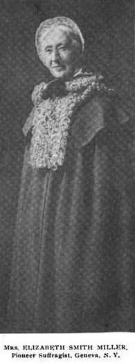
Elizabeth Smith Miller
Elizabeth Smith Miller ( Smith; September 20, 1822 – May 23, 1911), known as "Libby", was an American advocate and financial supporter of the women's rights movement.NY History Net (April 21, 2011). Biography Elizabeth Smith was born September 20, 1822 in Peterboro, New York. She was the daughter of antislavery philanthropist Gerrit Smith and his spouse, the abolitionist Ann Carroll Fitzhugh. In 1843, Elizabeth married Charles Dudley Miller. Elizabeth and Charles occupied the "Cottage Across the Brook", on her father's estate at Peterboro, New York. It was later the home of their son, Gerrit Smith Miller. The family later moved to Geneva, New York, where Miller died on May 23, 1911, aged 88. National Women's Right Convention At the third National Women's Rights Convention gavelled in Syracuse, Smith Miller was the author of a motion to create state-based women's rights organizations when the motion to create a national organization failed. She was with Elizabeth Cady Stan ... [...More Info...] [...Related Items...] OR: [Wikipedia] [Google] [Baidu] |
Town Green
A village green is a common open area within a village or other settlement. Historically, a village green was common grassland with a pond for watering cattle and other stock, often at the edge of a rural settlement, used for gathering cattle to bring them later on to a common land for grazing. Later, planned greens were built into the centres of villages. The village green also provided, and may still provide, an open-air meeting place for the local people, which may be used for public celebrations such as May Day festivities. The term is used more broadly to encompass woodland, moorland, sports grounds, buildings, roads and urban parks. History Most village greens in England originated in the Middle Ages. Individual greens may have been created for various reasons, including protecting livestock from wild animals or human raiders during the night, or providing a space for market trading. In most cases where a village green is planned, it is placed in the centre of a settle ... [...More Info...] [...Related Items...] OR: [Wikipedia] [Google] [Baidu] |
Saint John's Church (Hagerstown, Maryland)
St. John's Church, or St. John's Episcopal Church, founded in 1786, is an historic Episcopal church located at 101 South Prospect Street in the South Prospect Street Historic District of Hagerstown, Maryland. It is the seat of Saint John's Parish, Diocese of Maryland, which covers most of Washington County, Maryland. History Though it is the mother church of Saint John's Parish in the lower Cumberland valley, Saint John's Church Hagerstown is also one of the many daughter churches of Broad Creek Church of Piscataway Parish. The current physical church is the fourth since establishment of the “Chapel in the Woods” (1747) as a chapel of ease for All Saints Church (1742) in Frederick, Maryland. Services began in 1744, and four decades later the congregation erected a brick church on Mulberry Street in Hagerstown, the site of which is still maintained as the church cemetery. The General Assembly of Maryland separated the congregation from All Saints’ Frederick in 1786, ... [...More Info...] [...Related Items...] OR: [Wikipedia] [Google] [Baidu] |
Calvert County, Maryland
Calvert County is located in the U.S. state of Maryland. As of the 2020 census, the population was 92,783. Its county seat is Prince Frederick. The county's name is derived from the family name of the Barons of Baltimore, the proprietors of the English Colony of Maryland Calvert County is included in the Washington–Arlington–Alexandria, DC–VA–MD–WV Metropolitan Statistical Area. It occupies the Calvert Peninsula, which is bordered on the east by Chesapeake Bay and on the west by the Patuxent River. Calvert County is part of the Southern Maryland region. The county has one of the highest median household incomes in the United States. It is one of the older counties in Maryland, after St. Mary's, Kent County and Anne Arundel counties. History Early History In 1608, Captain John Smith was the first European to sail past Calvert County while exploring the western shore of the Chesapeake Bay. On his map, he accurately represented the Patuxent River as well as several ... [...More Info...] [...Related Items...] OR: [Wikipedia] [Google] [Baidu] |
Cecil County, Maryland
Cecil County () is a county located in the U.S. state of Maryland at the northeastern corner of the state, bordering both Pennsylvania and Delaware. As of the 2020 census, the population was 103,725. The county seat is Elkton. The county was named for Cecil Calvert, 2nd Baron Baltimore (1605–1675), the first Proprietary Governor of the Province (colony) of Maryland. With the eastern part of the county being closer to Philadelphia than to Baltimore, it is part of the Philadelphia-Camden-Wilmington, PA-NJ-DE-MD Metropolitan Statistical Area. The county is located in Wilmington's Radio Market and Baltimore's Designated Market Area. History The area now known as Cecil County was an important trading center long before the county's official organization in 1674 by proclamation of Lord Baltimore. It had previously been a northeastern part of a much larger Baltimore County, in the northeastern portion of the Province. This had included present-day Baltimore City and county, ... [...More Info...] [...Related Items...] OR: [Wikipedia] [Google] [Baidu] |
Stafford County, Virginia
Stafford County is located in the Commonwealth of Virginia. It is a suburb outside of Washington D.C. It is approximately south of D.C. It is part of the Northern Virginia region, and the D.C area. It is one of the fastest growing, and highest-income counties in America. As of the 2020 census, the population sits at 156,927. Its county seat is Stafford. Located across the Rappahannock River from the City of Fredericksburg, Stafford County is part of the Washington-Arlington-Alexandria, DC-VA-MD-WV Metropolitan Statistical Area. In 2006, and again in 2009, Stafford was ranked by ''Forbes'' magazine as the 11th highest-income county in the United States. According to a Census Bureau report released in 2019, Stafford County is currently the sixth highest-income county in America. History For thousands of years, various cultures of indigenous peoples succeeded each other in their territories along the Potomac River and its tributaries. By the time of English colonization, there ... [...More Info...] [...Related Items...] OR: [Wikipedia] [Google] [Baidu] |
Westmoreland County, Virginia
Westmoreland County is a county located in the Northern Neck of the Commonwealth of Virginia. As of the 2020 census, the population sits at 18,477. Its county seat is Montross. History As originally established by the Virginia colony's House of Burgesses, this area was separated from Northumberland County in 1653 and named for the English county of Westmorland; both counties are coastal. The territory of Westmoreland County encompassed much of what later became the various counties and cities of Northern Virginia, including the city of Alexandria, Arlington County, Fairfax County, and Prince William County. These areas comprised part of Westmoreland until the formation of Stafford County in 1664. Westmoreland County on Northern Neck was the birthplace of George Washington, who later became the first President of the United States (born at the former settlement of Bridges Creek, Virginia);Marquis, A.N. Company. ''Who's Who In America'', vol. 1:Historical Volume (1 ... [...More Info...] [...Related Items...] OR: [Wikipedia] [Google] [Baidu] |
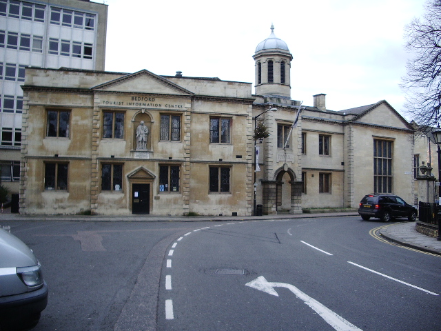
Bedford, England
Bedford is a market town in Bedfordshire, England. At the 2011 Census, the population of the Bedford built-up area (including Biddenham and Kempston) was 106,940, making it the second-largest settlement in Bedfordshire, behind Luton, whilst the Borough of Bedford had a population of 157,479. Bedford is also the historic county town of Bedfordshire. Bedford was founded at a ford on the River Great Ouse and is thought to have been the burial place of King Offa of Mercia, who is remembered for building Offa's Dyke on the Welsh border. Bedford Castle was built by Henry I, although it was destroyed in 1224. Bedford was granted borough status in 1165 and has been represented in Parliament since 1265. It is known for its large population of Italian descent. History The name of the town is believed to derive from the name of a Saxon chief called Beda, and a ford crossing the River Great Ouse. Bedford was a market town for the surrounding agricultural region from the early Middl ... [...More Info...] [...Related Items...] OR: [Wikipedia] [Google] [Baidu] |
Genesee Falls
Genesee Falls is an incorporated town in Wyoming County, New York. The population was 438 at the 2010 census. The Town of Genesee Falls is in the southeastern corner of the county. History The Town of Genesee Falls was established in 1846. The town was created from part of the Town of Pike and from part of the Town of Portage in Livingston County, New York. In 1876 a violent tornado struck Portageville, destroying buildings and injuring inhabitants. Geography According to the United States Census Bureau, the town has a total area of , of which is land and (1.08%) is water. The east town line is the border of Livingston County, New York ( Town of Portage). The south town line is the border of Allegany County New York ( Town of Hume). Demographics As of the census of 2000, there were 460 people, 170 households, and 126 families residing in the town. The population density was 29.6 people per square mile (11.4/km2). There were 194 housing units at an average density ... [...More Info...] [...Related Items...] OR: [Wikipedia] [Google] [Baidu] |
Nathaniel Rochester
Nathaniel Rochester (February 21, 1752 – May 17, 1831) was an American American Revolution, Revolutionary War soldier, and Speculation, land speculator, most noted for founding the settlement which would become Rochester, New York. Early life Nathaniel Rochester was born to John and Hester Thrift Rochester in Westmoreland County, Virginia on February 21, 1752, the fifth of six children. His father, who owned Rochester House, died in 1756. Five years later Hester married Thomas Cricher, who moved the family to Granville County, North Carolina in 1763, where Nathaniel attended the school of the Reverend Henry Pattillo. At age 16, he found a job with a local Hillsborough, North Carolina, Hillsborough merchant, signing a two-year contract paying £5 per year. At the end of six months, his contract was revised to pay him £20 per year and Rochester would become partner in the business within five years. In his early working years, Rochester also served as clerk for the vestry o ... [...More Info...] [...Related Items...] OR: [Wikipedia] [Google] [Baidu] |
Washington County, Maryland
Washington County is located in the western part of the U.S. state of Maryland. As of the 2020 census, the population was 154,705. Its county seat is Hagerstown. Washington County was the first county in the United States to be named for the Revolutionary War general (and later President) George Washington. Washington County is one of three Maryland counties recognized by the Appalachian Regional Commission as being part of Appalachia. The county borders southern Pennsylvania to the north, Northern Virginia to the south, and the Eastern Panhandle of West Virginia to the south and west. Washington County is included in the Hagerstown- Martinsburg, MD- WV Metropolitan Statistical Area, which is also included in the Washington-Baltimore- Arlington, DC-MD- VA-WV- PA Combined Statistical Area. History The western portions of the Province of Maryland (including present Washington County) were incorporated into Prince George's County in 1696. This original county included six cu ... [...More Info...] [...Related Items...] OR: [Wikipedia] [Google] [Baidu] |
Chewsville, Maryland
Chewsville is a census-designated place (CDP) in Washington County, Maryland, United States. The population was 293 at the 2000 census. Geography Chewsville is located at (39.643149, −77.635032). According to the United States Census Bureau, the CDP has a total area of , all land. Demographics 2010 2000 At the 2000 census there were 293 people, 117 households, and 74 families living in the CDP. The population density was . There were 125 housing units at an average density of . The racial makeup of the CDP was 98.98% White, 0.34% Asian, and 0.68% from two or more races. Of the 117 households 29.9% had children under the age of 18 living with them, 51.3% were married couples living together, 7.7% had a female householder with no husband present, and 35.9% were non-families. 29.1% of households were one person and 9.4% were one person aged 65 or older. The average household size was 2.50 and the average family size was 3.15. The age distribution was 29.0% under the a ... [...More Info...] [...Related Items...] OR: [Wikipedia] [Google] [Baidu] |


.png)


.png)