|
Andrijevica
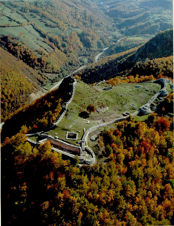
Andrijevica (Montenegrin Cyrillic: Андријевица, ) is a town and the seat of Andrijevica Municipality in eastern Montenegro. According to the 2011 census, it has a population of 1,048. History The town of Andrijevica is a relatively new settlement, as its first rudiments begin in the middle of the nineteenth century. However, the territory the municipality is for a long time the area of human activity and space with numerous settlements that appeared and disappeared during the history. Archaeological research of the ''Institute for monuments protection'' from Cetinje in 1956, it was discovered that traces of materialculture from Neolithic period exist in Berane valley. In addition, traces of the Illyrian culture were found also, so it can be assumed that the environment of Andrijevica was ecumenical space of numerous groups of people. Remainders of Roman settlements are also present in Berane valley, as well as in the vicinity of Andrijevica town. During the Middle age ... [...More Info...] [...Related Items...] OR: [Wikipedia] [Google] [Baidu] |
Andrijevica Municipality
Andrijevica Municipality is one of the municipalities of Montenegro. The center is the town of Andrijevica. Its territory is outspread on 340 km2 and it is surrounded by massives of mountains Komovi, Bjelasica and Accursed Mountains in northeastern Montenegro. Geography and tourism Andrijevica is surrounded by the mountains of Komovi, Bjelasica and Accursed Mountains, situated on a terrace 40m above river Lim. Tourist activities in the area includes mountaineering (alpinism, hiking), biking, rafting, sports (soccer, basketball), fishing, etc. Main tourist attraction is mountain Komovi (2461 m). This mountain can be accessed by a car in less than 45 minutes, by the mountainous Andrijevica - Mateševo road. Andrijevica is connected with rest of Montenegro by two-laned motorways. Local roads connect Andrijevica with Berane and Kolašin (both around away), where local roads merge with E65/ E80 road, which is main road connection of Montenegro's coast and Podgorica with nort ... [...More Info...] [...Related Items...] OR: [Wikipedia] [Google] [Baidu] |
Vasojevići
The Vasojevići ( sh, Васојевићи, ) is a historical highland tribe (''pleme'') and region of Montenegro, in the area of the Brda. It is the largest of the historical tribes, occupying the area between Lijeva Rijeka in the South up to Bihor under Bijelo Polje in the North, Mateševo in the West to Plav in the East. Likely of Albanian origin, most of the tribe's history prior to the 16th century has naturally been passed on through oral history. Although the unofficial center is Andrijevica in north-eastern Montenegro, the tribe stems from Lijeva Rijeka in central Montenegro. The tribe was formed by various tribes that were united under the rule of the central Vasojević tribe. These tribes later migrated to the Komovi mountains and the area of Lim. The emigration continued into what is today Serbia and other parts of Montenegro. Though sense of tribal affiliation diminished in recent years, is not a thing of a past. Tribal association and organizations still exist ... [...More Info...] [...Related Items...] OR: [Wikipedia] [Google] [Baidu] |
Municipalities Of Montenegro
The ''municipalities'' (Serbian language, Serbian: ''opštine'' / општине, singular: ''opština'' / општина) are the first level administrative subdivisions of Montenegro. The country is divided into 25 municipalities including the Old Royal Capital Cetinje and the Podgorica Capital City. Podgorica is divided into one subdivision called ''city municipality'' (Montenegrin: ''gradska opština'' / градска општина, plural: ''gradske opštine'' / градске општине), forming the most basic level of local government. Recently created: *Petnjica Municipality (2013) *Gusinje Municipality (2014) *Tuzi Municipality (2018) *Zeta Municipality (2022) ** The ''Union of Municipalities of Montenegro'' is a national association of local authorities of Montenegro. List Politics List of current mayors and local governments (6) (5) (3) (3) (2) (1) (1) (1) (1) (1) (1) Local parliaments of Montenegro See also *List of regions of Montenegro ... [...More Info...] [...Related Items...] OR: [Wikipedia] [Google] [Baidu] |
Vehicle Registration Plates Of Montenegro
Present Montenegrin car plates have black characters on a rectangular white background, with blue strip on the left. The plates follow the 520 mm x 110 mm format, except for motorcycles. The present licence plates format was introduced on 6 June 2008, and replaced the old format (format of Yugoslav licence plates) gradually over the following year. The new format is on par with common European Union format. Overview The plate is in following layout: to the left, a blue-colored field contains Montenegro's international automobile code (MNE); continuing in white background, the two-letter code of the municipality where the vehicle was registered in, then the coat-of-arms of Montenegro following by the registration code, which generally consists of two letters followed by three numbers. However, with an additional payment, it is possible to obtain the customized plates with any letter-number combination. Letters I and O are omitted in serial combinations because of th ... [...More Info...] [...Related Items...] OR: [Wikipedia] [Google] [Baidu] |
2011 Census Of Montenegro
This article is about the demographic features of the population of Montenegro, including population density, ethnicity, education level, health of the populace, economic status, religious affiliations and other aspects of the population. Population censuses *According to a 2015 estimate made by the Statistical Office of Montenegro, Montenegro has 622,159 inhabitants. *According to a 2016 estimate made by the Statistical Office of Montenegro, Montenegro has 622,303 inhabitants. *According to a 2017 estimate made by the Statistical Office of Montenegro, Montenegro has 622,373 inhabitants. *According to a 2018 estimate made by the Statistical Office of Montenegro, Montenegro has 622,227 inhabitants. *According to a 2019 estimate made by the Statistical Office of Montenegro, Montenegro has 622,028 inhabitants. Vital statistics Source: Statistical Office of Montenegro Current vital statistics Marriages and divorces Vital statistics, marriages and divorces by decade ... [...More Info...] [...Related Items...] OR: [Wikipedia] [Google] [Baidu] |
Skanderbeg Division
The 21st Waffen Mountain Division of the SS ''Skanderbeg'' (1st Albanian) was a German Gebirgsjäger, mountain infantry Division (military), division of the Waffen-SS, the armed wing of the German Nazi Party that served alongside, but was never formally part of, the Wehrmacht during World War II. At the post-war Nuremberg trials, the Waffen-SS was declared to be a criminal organisation due to its major involvement in war crimes and crimes against humanity. The division was developed around the nucleus of an ethnic Albanians, Albanian battalion which had briefly seen combat against the Yugoslav Partisans in eastern Bosnia (region), Bosnia as part of the 13th Waffen Mountain Division of the SS Handschar (1st Croatian), 13th Waffen Mountain Division of the SS ''Handschar'' (1st Croatian). Composed of Albanians with mostly German and Germans of Yugoslavia, Yugoslav ''Volksdeutsche'' (ethnic German) Officer (armed forces), officers and non-commissioned officers, it was given the tit ... [...More Info...] [...Related Items...] OR: [Wikipedia] [Google] [Baidu] |
Lim River
The Lim (Serbian Cyrillic: Лим, ) is a river that flows through Montenegro, Serbia and Bosnia and Herzegovina and is long.Statistical Yearbook of Montenegro 2017, Geography Statistical Office of Montenegro It is also the right and the longest tributary of the . Montenegro and Serbia [...More Info...] [...Related Items...] OR: [Wikipedia] [Google] [Baidu] |
Montenegro
) , image_map = Europe-Montenegro.svg , map_caption = , image_map2 = , capital = Podgorica , coordinates = , largest_city = capital , official_languages = Montenegrin , languages2_type = Languages in official use , languages2 = , ethnic_groups = , ethnic_groups_year = 2011 , religion = , religion_year = 2011 , demonym = Montenegrin , government_type = Unitary parliamentary republic , leader_title1 = President , leader_name1 = Milo Đukanović , leader_title2 = Prime Minister , leader_name2 = Dritan Abazović (acting) , leader_title3 = Speaker , leader_name3 = Danijela Đurović , legislature = Skupština , sovereignty_type = Establishment history , established_event1 = Principality of Duklja , established_date1 ... [...More Info...] [...Related Items...] OR: [Wikipedia] [Google] [Baidu] |
Raška (region)
Raška ( sr, Рашка; la, Rascia) is a geographical and historical region, covering the south-western parts of modern Serbia, and historically also including north-eastern parts of modern Montenegro, and some of the most eastern parts of modern Bosnia and Herzegovina. In the Middle Ages, the region was a center of the Serbian Principality and of the Serbian Kingdom, one central settlement of which was the city of Ras (a World Heritage Site) in the late 12th century. Its southern part corresponds to the region of Sandžak. Name The name is derived from the name of the region's most important fort of Ras, which first appears in the 6th century sources as ''Arsa'', recorded under that name in the work ''De aedificiis'' of Byzantine historian Procopius. By the 10th century, the variant ''Ras'' became common name for the fort, as attested by the work ''De Administrando Imperio'', written by Constantine Porphyrogenitus, and also by the Byzantine seal of John, governor of Ras ... [...More Info...] [...Related Items...] OR: [Wikipedia] [Google] [Baidu] |
Principality Of Zeta
The Principality of Zeta ( sr, Кнежевина Зета, Kneževina Zeta) is a historiographical name for a late medieval principality located in the southern parts of modern Montenegro and northern parts of modern Albania, around the Lake of Skadar. It was ruled by the families of Balšić, Lazarević, Branković and Crnojević in succession from the second half of the 14th century until Ottoman conquest at the very end of the 15th century. Previously, the same region of Zeta was a Serbian crown land, that had become self-governing after the fall of the Serbian Empire, when the Balšić family created a regional principality, sometime after 1360. Zeta under the Balšići * Balša I (1356–1362) * Đurađ I (1362–1378) * Balša II (1378–1385) * Đurađ II (1385–1403) * Balša III (1403–1421) Zeta under the Serbian Despotate * Despot Stefan Lazarević (1421–1427) * Despot Đurađ Branković (1427–1451) Zeta under the Crnojevići * Stefan I Crnojević (1 ... [...More Info...] [...Related Items...] OR: [Wikipedia] [Google] [Baidu] |
List Of Cities In Montenegro
This is a list of cities and towns with over 10,000 inhabitants (or lower if the municipality has over 20,000 inhabitants) in Montenegro. For the full list of populated places, see List of populated places in Montenegro. List For a list of municipalities, see Municipalities of Montenegro; for a category, see :Populated places in Montenegro; for a list of all places in Montenegro, see List of places in Montenegro. List of towns with over 10,000 inhabitants or lower if the municipality has over 20,000 inhabitants: See also *Municipalities of Montenegro * Regions of Montenegro * Populated places of Montenegro * Subdivisions of Montenegro References External links {{DEFAULTSORT:Cities In Montenegro Montenegro geography-related lists Montenegro ) , image_map = Europe-Montenegro.svg , map_caption = , image_map2 = , capital = Podgorica , coordinates = , largest_city = capital , o ... [...More Info...] [...Related Items...] OR: [Wikipedia] [Google] [Baidu] |
House Of Nemanjić
A house is a single-unit residential building. It may range in complexity from a rudimentary hut to a complex structure of wood, masonry, concrete or other material, outfitted with plumbing, electrical, and heating, ventilation, and air conditioning systems.Schoenauer, Norbert (2000). ''6,000 Years of Housing'' (rev. ed.) (New York: W.W. Norton & Company). Houses use a range of different roofing systems to keep precipitation such as rain from getting into the dwelling space. Houses may have doors or locks to secure the dwelling space and protect its inhabitants and contents from burglars or other trespassers. Most conventional modern houses in Western cultures will contain one or more bedrooms and bathrooms, a kitchen or cooking area, and a living room. A house may have a separate dining room, or the eating area may be integrated into another room. Some large houses in North America have a recreation room. In traditional agriculture-oriented societies, domestic animals such as c ... [...More Info...] [...Related Items...] OR: [Wikipedia] [Google] [Baidu] |


