|
Anamudi
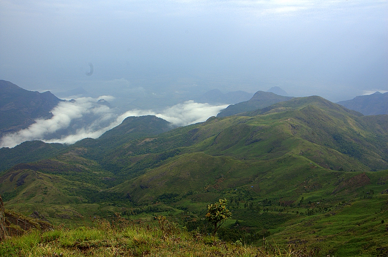
Anamudi is a mountain located in Ernakulam district and Idukki district of the Indian state of Kerala. It is the highest peak in the Western Ghats and in South India, at an elevation of and a topographic prominence of . The name Anamudi literally translates to "elephant's head" a reference to the resemblance of the mountain to an elephant's head. Anamudi is the highest mountain in peninsular India as well as the largest mountain in Kerala. Meanwhile, the highest independent mountain (free-standing mountain) in Kerala is the Cheriyam mountain in Malappuram district. Cheriyam mountain is located at an elevation of 613 m (2,011 ft) above sea level. The first recorded ascent of Anamudi was by General Douglas Hamilton of the Madras Army on 4 May 1862, but it is likely that there had been earlier ascents by local people. Anamudi peak is one of only three ultra prominent peaks in South India. It is also the peak with the greatest topographic isolation within India. It ... [...More Info...] [...Related Items...] OR: [Wikipedia] [Google] [Baidu] |
Eravikulam National Park
Eravikulam National Park is a 97 km2 national park located along the Western Ghats in the Idukki and Ernakulam districts of Kerala in India. Situated between 10º05'N and 10º20' north, and 77º0' and 77º10' east, (Semap) it is the first national park in Kerala. Eravikulam National Park is administered by the Kerala Department of Forests and Wildlife, Munnar Wildlife Division, which also runs the nearby Mathikettan Shola National Park, Anamudi Shola National Park, Pambadum Shola National Park, Chinnar Wildlife Sanctuary and the Kurinjimala Sanctuary. Geography The main body of the park consists of a high rolling hill plateau with a base elevation of about 2,000 m. The terrain consists of high altitude grasslands interspersed with sholas. Anamudi, 2,695 meters, the highest peak in South India is inside this park. Many perennial streams criss-cross the park. They merge to form tributaries of the Periyar river in the west and of the Cauvery River in the east. ... [...More Info...] [...Related Items...] OR: [Wikipedia] [Google] [Baidu] |
List Of Indian States And Territories By Highest Point
This is the alphabetical list of the highest points of the Indian States and union territories of India, states and union territories. States Union territories Gallery Image:Kangchenjunga.jpg, Kangchenjunga (8,586 m) Image:Nanda devi.jpg, Nanda Devi (7,816 m) Image:Saltoro_Kangri.jpg, Saltoro Kangri (7,742m) Image:View_of_Nun_Kun_massif_from_airplane.jpg, Nun Kun (7,135 m) Image:The_Kangto_Peak_(The_highest_peak_in_the_North-east_after_Kanchenjunga).jpg, Kangto (7,090 m) Image:LeoPargial.jpg, Reo_Purgyil(6,816 m) Image:Sandakphu.jpg, Sandakphu (3,636 m) Image:Anamudi peak, Munnar.jpg, Anamudi (2,695 m) Image:Guru Shikhar Mount Abu.jpg, Gurushikhar Mount Abu (1,722 m) Image:Kalsubai.jpg, Kalsubai (1,646 m) See also * List of hill stations in India * List of mountains in India * List of the tallest statues in India * List of tallest buildings in India * List of tallest structures in India * Rameswaram TV Tower, tallest Towers in India * Tourism in India References ... [...More Info...] [...Related Items...] OR: [Wikipedia] [Google] [Baidu] |
List Of Ultras Of Tibet, East Asia And Neighbouring Areas
This is a list of all the Ultra prominent peaks (with topographic prominence greater than 1,500 metres) in Tibet, China, East Asia and neighbouring areas of Burma and India, including South India and Sri Lanka. Kunlun Mountains and Northeastern Tibet Plateau Western Tibet and neighboring areas South-eastern Tibet and neighboring areas Yunnan Daxue Mountains of Sichuan Contiguous Eastern China Taiwan and Hainan South India and Sri Lanka , References External links E. Jurgalski and others:List of Ultras in Tibet * [...More Info...] [...Related Items...] OR: [Wikipedia] [Google] [Baidu] |
Anaimalai Hills
The Anamala or Anaimalai, also known as the Elephant Mountains, are a range of mountains in the southern Western Ghats of central Kerala ( Idukki district, Ernakulam district, Palakkad district, Thrissur district) and span the border of western Tamil Nadu (Coimbatore district and Tiruppur district) in Southern India. The name ''anamala'' is derived from the Malayalam word ''aana and'' the Tamil word ''aanai'', meaning elephant, or from tribal languages. ''Mala'' or ''Malai'' means 'hill', and thus 'Elephant hill'. Anamudi Peak (8,842 feet (2,695 metres)) lies at the southern end of the range and is the highest peak in southern India. The Palakkad Gap is the mountain pass which divides it from the Nilgiri Mountains. The northern slopes of the hills in Tamil Nadu now have coffee and tea plantations(especially around Valparai), as well as teak plantations of high economic value. The rest are mostly forests, of mainly two ecoregions-the South Western Ghats moist d ... [...More Info...] [...Related Items...] OR: [Wikipedia] [Google] [Baidu] |
Kerala
Kerala ( ; ) is a state on the Malabar Coast of India. It was formed on 1 November 1956, following the passage of the States Reorganisation Act, by combining Malayalam-speaking regions of the erstwhile regions of Cochin, Malabar, South Canara, and Thiruvithamkoor. Spread over , Kerala is the 21st largest Indian state by area. It is bordered by Karnataka to the north and northeast, Tamil Nadu to the east and south, and the Lakshadweep Sea to the west. With 33 million inhabitants as per the 2011 census, Kerala is the 13th-largest Indian state by population. It is divided into 14 districts with the capital being Thiruvananthapuram. Malayalam is the most widely spoken language and is also the official language of the state. The Chera dynasty was the first prominent kingdom based in Kerala. The Ay kingdom in the deep south and the Ezhimala kingdom in the north formed the other kingdoms in the early years of the Common Era (CE). The region had been a prominent spice exp ... [...More Info...] [...Related Items...] OR: [Wikipedia] [Google] [Baidu] |
Cardamom Hills
The Cardamom Hills or Yela Mala are mountain range of southern India and part of the southern Western Ghats located in Idukki district, Kerala, India. Their name comes from the cardamom spice grown in much of the hills' cool elevation, which also supports pepper and coffee. The Western Ghats and Periyar Sub-Cluster including the Cardamom Hills are UNESCO World Heritage Sites.UNESCO Retrieved 20 April 2007. Geography The Cardamom Hills central point is about . They cover about 2,800 km2 of mountainous terrain with deep valleys, and includes the drainages of the west flowing Periyar River, Periyar, Mullayar and Pamba rivers. It includes Idukki Dam and Mullaperiyar Dam. They conjoin the Anaimalai Hills to the northwest, the Palani Hills to the northeast and the Pothigai to the south as far as the Aryankavu pass (at c. 9° N). The crest of the hills form the boundary between Kerala and Tamil Nadu. Anamudi (8,842 ft (2695 m)) in Eravikulam National ... [...More Info...] [...Related Items...] OR: [Wikipedia] [Google] [Baidu] |
Ernakulam District
Ernakulam, ; ISO: ''Eṟaṇākuḷaṁ'', in Malayalam: എറണാകുളം), is one of the 14 districts in the Indian state of Kerala, that takes its name from the eponymous city division in Kochi. It is situated in the central part of the state, spans an area of about , and is home to over 9% of Kerala's population. Its headquarters are located at Kakkanad. The district includes Kochi, also known as the commercial capital of Kerala, which is famous for its ancient Churches, Hindu temples, synagogues and mosques. The district includes the largest metropolitan region of the state: Greater Cochin. Ernakulam is the district that yields the most revenue and the largest number of industries in the state. Ernakulam is the third most populous district in Kerala, after Malappuram and Thiruvananthapuram (out of 14 districts). The district also hosts the highest number of international and domestic tourists in Kerala state. The most commonly spoken language in Ernakulam is ... [...More Info...] [...Related Items...] OR: [Wikipedia] [Google] [Baidu] |
Topographic Isolation
The topographic isolation of a summit is the minimum distance to a point of equal elevation, representing a radius of dominance in which the peak is the highest point. It can be calculated for small hills and islands as well as for major mountain peaks and can even be calculated for submarine summits. Isolation table The following sortable table lists Earth's 40 most topographically isolated summits. Examples *The nearest peak to Germany's highest mountain, the 2,962-metre-high Zugspitze, that has a 2962-metre-contour is the Zwölferkogel (2,988 m) in Austria's Stubai Alps. The distance between the Zugspitze and this contour is 25.8 km; the Zugspitze is thus the highest peak for a radius of 25.8 km around. Its isolation is thus 25.8 km. *Because there are no higher mountains than Mount Everest, it has no definitive isolation. Many sources list its isolation as the circumference of the earth over the poles or – questionably, because there is no agre ... [...More Info...] [...Related Items...] OR: [Wikipedia] [Google] [Baidu] |
Munnar
Munnar () is a town and hill station in the Idukki district of the southwestern Indian state of Kerala. Munnar is situated at around above mean sea level, in the Western Ghats mountain range. Munnar is also called the " Kashmir of South India" and is a popular honeymoon destination. Etymology The name Munnar is believed to mean "three rivers", referring to its location at the confluence of the Mudhirapuzha, Nallathanni and Kundali rivers. History The region has been inhabited by hunter-gatherer tribals like the Malayarayan and Muthuvan for thousands of years. Tradition states that Colonel Arthur Wellesley, later the Duke of Wellington, was the first British person to pass through Munnar during Tippu Sultan's campaign in Travancore, but this is unsubstantiated. The first survey of the terrain was undertaken by Benjamin Swayne Ward in 1816–1817, who followed the Periyar into the Western Ghats and established a camp at the confluence of three rivers, from which the nam ... [...More Info...] [...Related Items...] OR: [Wikipedia] [Google] [Baidu] |
Palani Hills
The Palani Hills are a mountain range in the southern Indian states of Kerala and Tamil Nadu. The Palani Hills are an eastward extension of the Western Ghats ranges, which run parallel to the west coast of India. The Palani Hills adjoin the high Anamalai range (Kerala) on the west, and extend east into the plains of Tamil Nadu, covering an area of . The highest part of the range is in the southwest, and reaches 1,800-2,500 metres (5,906-8,202 feet) elevation; the eastern extension of the range is made up of hills 1,000-1,500 m (3,281-4,921 ft) high. It is also home to the main temple of Lord Muruga, who is worshipped as the primary god in Tamil Nadu. Geography Vandaravu peak is the highest peak in the Palani hills. The range lies between the Cumbum Valley on the south, which is drained by the Vaigai River and its upper tributaries, and the Kongunadu region to the north. The northern slopes are drained by the Shanmukha River, Nanganji River, and Kodavanar River, whi ... [...More Info...] [...Related Items...] OR: [Wikipedia] [Google] [Baidu] |
Malappuram District
Malappuram (), is one of the 14 districts in the Indian state of Kerala, with a coastline of . It is the most populous district of Kerala, which is home to around 13% of the total population of the state. The district was formed on 16 June 1969, spanning an area of about . It is the third-largest district of Kerala by area, as well as the largest district in the state, bounded by Western Ghats and Arabian Sea to either side. The district is divided into seven Taluks: Eranad, Kondotty, Nilambur, Perinthalmanna, Ponnani, Tirur, and Tirurangadi. Malayalam is the most spoken language. The district has witnessed significant emigration, especially to the Arab states of the Persian Gulf during the Gulf Boom of the 1970s and early 1980s, and its economy depends significantly on remittances from a large Malayali expatriate community. Malappuram was the first e-literate as well as the first cyber literate district of India. The district has four major rivers, namely Bharath ... [...More Info...] [...Related Items...] OR: [Wikipedia] [Google] [Baidu] |
Asian Elephant
The Asian elephant (''Elephas maximus''), also known as the Asiatic elephant, is the only living species of the genus '' Elephas'' and is distributed throughout the Indian subcontinent and Southeast Asia, from India in the west, Nepal in the north, Sumatra in the south, and to Borneo in the east. Three subspecies are recognised—'' E. m. maximus'' from Sri Lanka, ''E. m. indicus'' from mainland Asia and '' E. m. sumatranus'' from the island of Sumatra. Formerly, there was also the Syrian elephant or Western Asiatic elephant (''Elephas maximus asurus'') which was the westernmost population of the Asian elephant (''Elephas maximus''). This subspecies became extinct in ancient times. Skeletal remains of ''E. m. asurus'' have been recorded from the Middle East: Iran, Iraq, Syria, and Turkey from periods dating between at least 1800 BC and likely 700 BC. It is one of only three living species of elephants or elephantids anywhere in the world, the others being the Africa ... [...More Info...] [...Related Items...] OR: [Wikipedia] [Google] [Baidu] |
_female_head.jpg)


.jpg)
