|
Anakapalli District
Anakapalli district is a district in the Indian state of Andhra Pradesh. It was formed on 4 April 2022 from Anakapalli and Narsipatnam revenue divisions of the old Visakhapatnam district. The administrative headquarters are at Anakapalli. Sankaram, 3 km from Anakapalli is identified to be developed as the headquarters of the new district. Etymology This district name is derived from its headquarters Anakapalli. Geography This district is surrounded by Alluri Sitharama Raju district to the north, Kakinada district to the west, the Bay of Bengal to the south and Vizianagaram district and Visakhapatnam district to the east. Politics There are one parliamentary and 7 assembly constituencies in Anakapalli district. The parliamentary constituencies are The assembly constituencies are Administrative divisions The district is divided into 2 revenue divisions: Anakapalli and Narsipatnam, which are further subdivided into 24 mandals, each headed by a sub-collecto ... [...More Info...] [...Related Items...] OR: [Wikipedia] [Google] [Baidu] |
States And Union Territories Of India
India is a federal union comprising 28 states and 8 union territories, with a total of 36 entities. The states and union territories are further subdivided into districts and smaller administrative divisions. History Pre-independence The Indian subcontinent has been ruled by many different ethnic groups throughout its history, each instituting their own policies of administrative division in the region. The British Raj mostly retained the administrative structure of the preceding Mughal Empire. India was divided into provinces (also called Presidencies), directly governed by the British, and princely states, which were nominally controlled by a local prince or raja loyal to the British Empire, which held ''de facto'' sovereignty ( suzerainty) over the princely states. 1947–1950 Between 1947 and 1950 the territories of the princely states were politically integrated into the Indian union. Most were merged into existing provinces; others were organised into ... [...More Info...] [...Related Items...] OR: [Wikipedia] [Google] [Baidu] |
Adivasi
The Adivasi refers to inhabitants of Indian subcontinent, generally tribal people. The term is a Sanskrit word coined in the 1930s by political activists to give the tribal people an indigenous identity by claiming an indigenous origin. The term is also used for ethnic minorities, such as Chakmas of Bangladesh, Khas of Nepal, and Vedda of Sri Lanka. The Constitution of India does not use the word ''Adivasi'', instead referring to Scheduled Tribes and Janjati. The government of India does not officially recognise tribes as indigenous people. The country ratified the International Labour Organization (ILO) Convention 107 on Indigenous and Tribal Peoples of the United Nations (1957) and refused to sign the ILO Convention 169. Most of these groups are included in the Scheduled Tribe category under constitutional provisions in India. They comprise a substantial minority population of India and Bangladesh, making up 8.6% of India's population and 1.1% of Bangladesh's, or 104.2&n ... [...More Info...] [...Related Items...] OR: [Wikipedia] [Google] [Baidu] |
Dalit
Dalit (from sa, दलित, dalita meaning "broken/scattered"), also previously known as untouchable, is the lowest stratum of the Caste system in India, castes in India. Dalits were excluded from the four-fold Varna (Hinduism), varna system of Hinduism and were seen as forming a avarna, fifth varna, also known by the name of ''Panchama''. Dalits now profess various religious beliefs, including Hinduism, Buddhism, Sikhism, Christianity, Islam. Scheduled Castes is the official term for Dalits as per the Constitution of India. History The term ''Dalit'' is a self-applied concept for those called the "untouchables" and others that were outside of the traditional Hindu caste hierarchy. Economist and reformer B. R. Ambedkar (1891–1956) said that untouchability came into Indian society around 400 CE, due to the struggle for supremacy between Buddhism and Historical Vedic religion, Brahmanism (an ancient term for Brahmanical Hinduism). Some Hindu priests befriended untouchables ... [...More Info...] [...Related Items...] OR: [Wikipedia] [Google] [Baidu] |
Vizianagaram District
Vizianagaram district is one of the six districts in the Uttarandhra region of the Indian state of Andhra Pradesh with its headquarters located at Vizianagaram. The district was once the part of ancient Kalinga.Saripilli Dibbilingeswara temple, Jayathi Mallikarjuna Temple are the finest examples of ancient Eastern Ganga Dynasty built monuments in the district.The district is bounded on the east by the district of Srikakulam, north by Parvathipuram Manyam south by Visakhapatnam, Anakapalli, southeast by the Bay of Bengal, and west by Alluri Sitharama Raju district. It was formed on 1 June 1979, with some parts carved from the neighbouring districts of Srikakulam and Visakhapatnam. The district is named after the princely state of Vizianagaram (''Vijaya'' means victory and ''Nagaram'' means city in Telugu). In 2011, it was the least populous district in Andhra Pradesh. Vizianagaram district was formed on 1 June 1979, as per G.O.Ms.No.700/Revenue (U) Department, dated 15 May ... [...More Info...] [...Related Items...] OR: [Wikipedia] [Google] [Baidu] |
Bay Of Bengal
The Bay of Bengal is the northeastern part of the Indian Ocean, bounded on the west and northwest by India, on the north by Bangladesh, and on the east by Myanmar and the Andaman and Nicobar Islands of India. Its southern limit is a line between Sangaman Kanda, Sri Lanka, and the north westernmost point of Sumatra, Indonesia. It is the largest water region called a bay in the world. There are countries dependent on the Bay of Bengal in South Asia and Southeast Asia. During the existence of British India, it was named as the Bay of Bengal after the historic Bengal region. At the time, the Port of Kolkata served as the gateway to the Crown rule in India. Cox's Bazar, the longest sea beach in the world and Sundarbans, the largest mangrove forest and the natural habitat of the Bengal tiger, are located along the bay. The Bay of Bengal occupies an area of . A number of large rivers flow into the Bay of Bengal: the Ganges– Hooghly, the Padma, the Brahmaputra–Yamuna, the Barak� ... [...More Info...] [...Related Items...] OR: [Wikipedia] [Google] [Baidu] |
Kakinada District
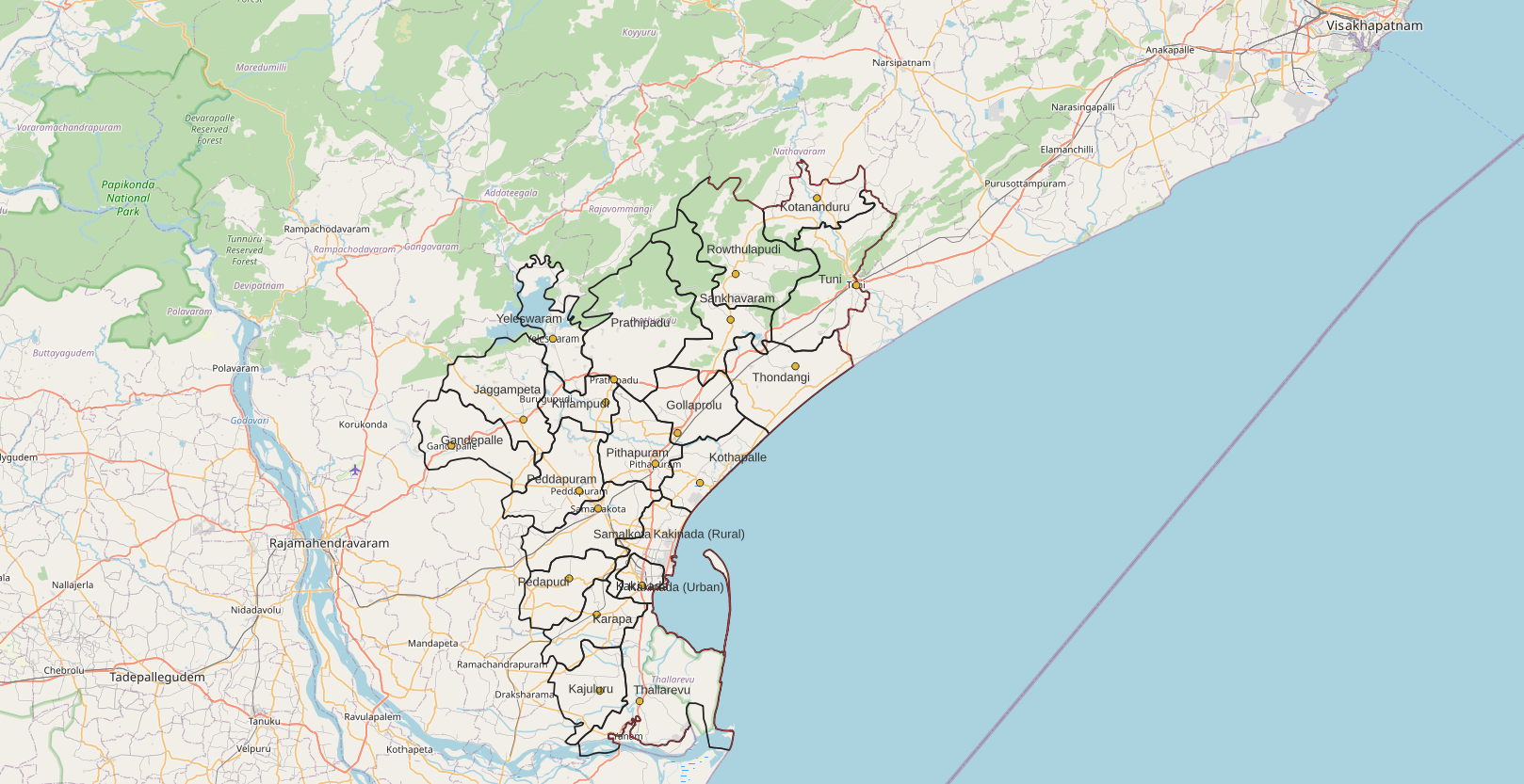
Kakinada district is a district in the Coastal Andhra Region in the Indian state of Andhra Pradesh. With Kakinada as its administrative headquarters, it was proposed on 26 January 2022 to become one of the resultant List of districts of Andhra Pradesh, twenty six districts in the state after the final notification has been issued on 4 April 2022 by the government of Andhra Pradesh. The district was formed from Kakinada revenue division, Kakinada and Peddapuram revenue division, Peddapuram revenue divisions from East Godavari district. Incidentally, during earlier times, the region comprising towns Pithapuram, Kakinada and Peddapuram were referred as ''Polnaud'' or ''Prolunadu'' (), which now roughly corresponds to the areas in this district. Etymology This district name derives from its headquarters Kakinada. Geography This district is surrounded by North of Alluri Sitharama Raju district, South of Bay of Bengal & Yanam district, East of Anakapalli district and west of East ... [...More Info...] [...Related Items...] OR: [Wikipedia] [Google] [Baidu] |
Alluri Sitharama Raju District
Alluri Sitharama Raju district, also known as Alluri district and by its initials as ASR district, is a district in the Indian state of Andhra Pradesh. The headquarters of the district is located at Paderu. Named after Alluri Sitarama Raju, a revolutionary in the Indian independence movement who hailed from the region, the district was effective since 4 April 2022 and became one of the twenty-six districts in the state. The district famous for its scenic beauty , falls in the lap of Eastern Ghats. History In July 2019, on the occasion of Alluri Sitarama Raju's 122nd birth anniversary, state Tourism Minister Avanthi Srinivasa Rao said a newly formed district would be named after Alluri Sitarama Raju. The district was proposed on 26 January 2022 by the Y. S. Jagan Mohan Reddy's government as part of a reorganisation of all the existing 13 districts in the state to form 26 districts in total. Final notification was issued by the Government of Andhra Pradesh on 3 April 2022 and ... [...More Info...] [...Related Items...] OR: [Wikipedia] [Google] [Baidu] |


_according_to_Indian_Caste_System_-_1942.jpg)


