|
Amarume, Yamagata
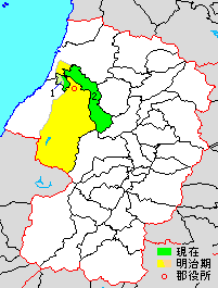
was a town located in Higashitagawa District, Yamagata Prefecture, Japan. On July 1, 2005, Amarume, along with the town of Tachikawa file:Autumn colors in Showa memorial park.jpg, 250px, Showa Memorial Park is a Cities of Japan, city located in the western portion of Tokyo Metropolis, Japan. , the city had an estimated population of 184,383 in 93,428 households, and a populat ... (also from Higashitagawa District), was merged to create the town of Shōnai. Dissolved municipalities of Yamagata Prefecture {{Yamagata-geo-stub ... [...More Info...] [...Related Items...] OR: [Wikipedia] [Google] [Baidu] |
List Of Towns In Japan
A town (町; ''chō'' or ''machi'') is a local administrative unit in Japan. It is a local public body along with prefecture (''ken'' or other equivalents), city (''shi''), and village (''mura''). Geographically, a town is contained within a district. Note that the same word (町; ''machi'' or ''chō'') is also used in names of smaller regions, usually a part of a ward in a city. This is a legacy of when smaller towns were formed on the outskirts of a city, only to eventually merge into it. Towns See also * Municipalities of Japan * Japanese addressing system The Japanese addressing system is used to identify a specific location in Japan. When written in Japanese characters, addresses start with the largest geographical entity and proceed to the most specific one. When written in Latin characters, ad ... References {{reflist External links "Large_City_System_of_Japan";_graphic_shows_towns_compared_with_other_Japanese_city_types_at_p._1_[PDF_7_of_40/nowiki>">DF_7_of_4 ... [...More Info...] [...Related Items...] OR: [Wikipedia] [Google] [Baidu] |
Higashitagawa District, Yamagata
is a rural district located in Yamagata Prefecture, Japan. As of October 2013, the district has an estimated population of 29,957 and an area of 282.47 km2. Much of the city of Tsuruoka and a portion of the city of Sakata was formerly part of Higashitagawa District. Towns and villages * Mikawa * Shōnai History Tagawa County was an ancient place name in part of Dewa Province. It was divided into Higashitagawa District and Nishitagawa District after the Meiji restoration. Under the Tokugawa shogunate, much of the area of both districts were ruled as part of Tsuruoka Domain. The area became part of Yamagata Prefecture in 1876. At that time, Higashitagawa District consisted of 259 villages. With the establishment of the municipality system on April 1, 1889, the district was consolidated into 26 villages. * On May 5, 1918, Amarume was raised to town status * On May 19, 1922, Fujishima was raised to town status * On April 1, 1937, Karikawa was raised to town status * On ... [...More Info...] [...Related Items...] OR: [Wikipedia] [Google] [Baidu] |
Yamagata Prefecture
is a prefecture of Japan located in the Tōhoku region of Honshu. Yamagata Prefecture has a population of 1,079,950 (1 June 2019) and has a geographic area of 9,325 km² (3,600 sq mi). Yamagata Prefecture borders Akita Prefecture to the north, Miyagi Prefecture to the east, Fukushima Prefecture to the south, and Niigata Prefecture to the southwest. Yamagata is the capital and largest city of Yamagata Prefecture, with other major cities including Tsuruoka, Sakata, and Yonezawa. Yamagata Prefecture is located on Japan's western Sea of Japan coast and its borders with neighboring prefectures are formed by various mountain ranges, with 17% of its total land area being designated as Natural Parks. Yamagata Prefecture formed the southern half of the historic Dewa Province with Akita Prefecture and is home to the Three Mountains of Dewa, which includes the Haguro Five-story Pagoda, a recognised National Treasure of Japan. History The aboriginal people once inhabited the area ... [...More Info...] [...Related Items...] OR: [Wikipedia] [Google] [Baidu] |
Japan
Japan ( ja, 日本, or , and formally , ''Nihonkoku'') is an island country in East Asia. It is situated in the northwest Pacific Ocean, and is bordered on the west by the Sea of Japan, while extending from the Sea of Okhotsk in the north toward the East China Sea, Philippine Sea, and Taiwan in the south. Japan is a part of the Ring of Fire, and spans Japanese archipelago, an archipelago of List of islands of Japan, 6852 islands covering ; the five main islands are Hokkaido, Honshu (the "mainland"), Shikoku, Kyushu, and Okinawa Island, Okinawa. Tokyo is the Capital of Japan, nation's capital and largest city, followed by Yokohama, Osaka, Nagoya, Sapporo, Fukuoka, Kobe, and Kyoto. Japan is the List of countries and dependencies by population, eleventh most populous country in the world, as well as one of the List of countries and dependencies by population density, most densely populated and Urbanization by country, urbanized. About three-fourths of Geography of Japan, the c ... [...More Info...] [...Related Items...] OR: [Wikipedia] [Google] [Baidu] |
Tachikawa, Yamagata
was a town located in Higashitagawa District), Yamagata Prefecture, Japan Japan ( ja, 日本, or , and formally , ''Nihonkoku'') is an island country in East Asia. It is situated in the northwest Pacific Ocean, and is bordered on the west by the Sea of Japan, while extending from the Sea of Okhotsk in the north .... On July 1, 2005, Tachikawa, along with the town of Amarume (also from Higashitagawa District, was merged to create the town of Shōnai. Dissolved municipalities of Yamagata Prefecture {{Yamagata-geo-stub ... [...More Info...] [...Related Items...] OR: [Wikipedia] [Google] [Baidu] |
Shōnai, Yamagata
is a Towns of Japan, town located in Yamagata Prefecture, Japan. , the town has an estimated population of 20,940 in 7108 households, and a population density of 87.5 per km². The total area of the town is . Geography Shōnai is located in the coastal plains of north-central Yamagata Prefecture. The Mogami River flows through the town. Mount Gassan, the highest of the Three Mountains of Dewa is at the intersection of the borders of Shōnai, Tsuruoka, Ōkura and Nishikawa. Neighboring municipalities *Yamagata Prefecture **Tsuruoka, Yamagata, Tsuruoka **Sakata, Yamagata, Sakata **Mikawa, Yamagata, Mikawa **Tozawa, Yamagata, Tozawa **Ōkura, Yamagata, Ōkura **Nishikawa, Yamagata, Nishikawa Climate Shōnai has a Humid continental climate (Köppen climate classification ''Cfa'') with large seasonal temperature differences, with warm to hot (and often humid) summers and cold (sometimes severely cold) winters. Precipitation is significant throughout the year, but is heaviest from Aug ... [...More Info...] [...Related Items...] OR: [Wikipedia] [Google] [Baidu] |

