|
Amaravila
Amaravila is a village in Neyyattinkara town in Trivandrum district, Kerala State, India. Kerala's second largest checkpost after Walayar is situated in Amaravila. This village is situated in NH 47 on the way to Kanyakumari, on the Kerala-Tamil Nadu border. Amaravila CSI church or CSI Amaravila, founded in 1810 and known in those days as Emily Chapel, an old Anglican Church (Anglican Communion), is one of the main attractions of this village. See also * Neyyattinkara * Neyyattinkara Railway Station * Neyyattinkara Sree Krishna Swami Temple * Thiruvananthapuram * Municipalities of Kerala * Upper cloth revolt The Channar Lahala or Channar revolt, also called Maru Marakkal Samaram, refers to the fight from 1813 to 1859 of Nadar climber women in Travancore kingdom of India for the right to wear upper-body clothes covering their breasts. Background ... References {{Thiruvananthapuram district settlements Villages in Thiruvananthapuram district ... [...More Info...] [...Related Items...] OR: [Wikipedia] [Google] [Baidu] |
Neyyattinkara
Neyyattinkara, is a Municipal Town and a major industrial and commercial hub located at the southern tip of Thiruvananthapuram metropolitan area in Trivandrum, the capital of Kerala State, and also the headquarters of Neyyattinkara Taluk. The town is situated on the banks of Neyyar River, one of the principal rivers in the district and hence its name. Neyyatinkara in Malayalam literally means "the shore of the river Neyyar". Neyyattinkara is the second most densely populated municipality in the district after Varkala. Administration The town comes under the purview of Neyyattinkara Municipality. It also comes under the Neyyattinkara (State Assembly constituency), Neyyatinkara Assembly Constituency which inturn comes under the Thiruvananthapuram (Lok Sabha constituency), Thiruvananthapuram Lok Sabha Constituency. The town is mostly residential, with many government and service sector establishments. The standard and generally accepted abbreviations of Neyyattinkara are NTA (used ... [...More Info...] [...Related Items...] OR: [Wikipedia] [Google] [Baidu] |
Kerala
Kerala ( ; ) is a state on the Malabar Coast of India. It was formed on 1 November 1956, following the passage of the States Reorganisation Act, by combining Malayalam-speaking regions of the erstwhile regions of Cochin, Malabar, South Canara, and Thiruvithamkoor. Spread over , Kerala is the 21st largest Indian state by area. It is bordered by Karnataka to the north and northeast, Tamil Nadu to the east and south, and the Lakshadweep Sea to the west. With 33 million inhabitants as per the 2011 census, Kerala is the 13th-largest Indian state by population. It is divided into 14 districts with the capital being Thiruvananthapuram. Malayalam is the most widely spoken language and is also the official language of the state. The Chera dynasty was the first prominent kingdom based in Kerala. The Ay kingdom in the deep south and the Ezhimala kingdom in the north formed the other kingdoms in the early years of the Common Era (CE). The region had been a prominent spic ... [...More Info...] [...Related Items...] OR: [Wikipedia] [Google] [Baidu] |
Municipalities Of Kerala
Kerala has an urbanisation rate of 47.42%, as compared to the national rate of 31.16%, making it the 2nd most urbanised major state in India. Within Kerala, the rate of urbanisation varied from 3.9% in Wayanad district, Wayanad district to 68.1% in Ernakulam district, Ernakulam district. Municipalities are the urban local governments that deal with civic functions and local development functions in the municipal area. The state of Kerala has 87 municipalities and six municipal corporations. With 13 municipalities, the district of Ernakulam has the most municipalities in the state. History The urban councils of Kerala date back to the 17th century when the Dutch Malabar established the municipality of Fort Kochi. In 1664, the municipality of Fort Kochi was established by Dutch Malabar, making it the first municipality in Indian subcontinent, which got dissolved when the Dutch authority got weaker in 18th century. However, the first modern kind of municipalities were formed in th ... [...More Info...] [...Related Items...] OR: [Wikipedia] [Google] [Baidu] |
Thiruvananthapuram
Thiruvananthapuram (; ), also known by its former name Trivandrum (), is the capital of the Indian state of Kerala. It is the most populous city in Kerala with a population of 957,730 as of 2011. The encompassing urban agglomeration population is around 1.68 million. Located on the west coast of India near the extreme south of the mainland, Thiruvananthapuram is a major information technology hub in Kerala and contributes 55% of the state's software exports as of 2016. Referred to by Mahatma Gandhi as the "Evergreen city of India", the city is characterised by its undulating terrain of low coastal hills. The present regions that constitute Thiruvananthapuram were ruled by the Ays who were feudatories of the Chera dynasty. In the 12th century, it was conquered by the Kingdom of Venad. In the 18th century, the king Marthanda Varma expanded the territory, founded the princely state of Travancore, and made Thiruvananthapuram its capital. Travancore became the most dominan ... [...More Info...] [...Related Items...] OR: [Wikipedia] [Google] [Baidu] |
Neyyattinkara Sree Krishna Swami Temple
Neyyattinkara Sree Krishna Swamy Temple is a Lord Krishna temple situated at Neyyattinkara, 20 km south of Thiruvananthapuram city, in Kerala. One of the important temples of Lord Krishna, the temple is also of great historic importance as well. The temple enshrines Unnikannan in the form of ( Navaneetha Krishna) as the presiding deity. Thrikkayyilvenna or Thrikkayyil Venna (butter) is a unique offering to Neyyattinkara Unnikannan – the deity of the temple. World famous musicians, Sri. Neyyattinkara Mohanachandran and Neyyaattinkara Vasudevan used to perform concerts regularly in temple festival. Legend and history Neyyattinkara Shri Krishnaswamy Temple is supposed to be built in between AD 1750 - AD 1755, by His Highness Anizham Thirunal Marthanda Varma, the then maharajah of the erstwhile Indian princely state of Travancore. The history/legend behind the construction of this temple is, the then ruler, His Highness Anizham Thirunal Marthandavarma was surrounded by hi ... [...More Info...] [...Related Items...] OR: [Wikipedia] [Google] [Baidu] |
Anglican Communion
The Anglican Communion is the third largest Christian communion after the Roman Catholic and Eastern Orthodox churches. Founded in 1867 in London, the communion has more than 85 million members within the Church of England and other autocephalous national and regional churches in full communion. The traditional origins of Anglican doctrine are summarised in the Thirty-nine Articles (1571). The Archbishop of Canterbury (, Justin Welby) in England acts as a focus of unity, recognised as ' ("first among equals"), but does not exercise authority in Anglican provinces outside of the Church of England. Most, but not all, member churches of the communion are the historic national or regional Anglican churches. The Anglican Communion was officially and formally organised and recognised as such at the Lambeth Conference in 1867 in London under the leadership of Charles Longley, Archbishop of Canterbury. The churches of the Anglican Communion consider themselves to be part of ... [...More Info...] [...Related Items...] OR: [Wikipedia] [Google] [Baidu] |
Kanyakumari
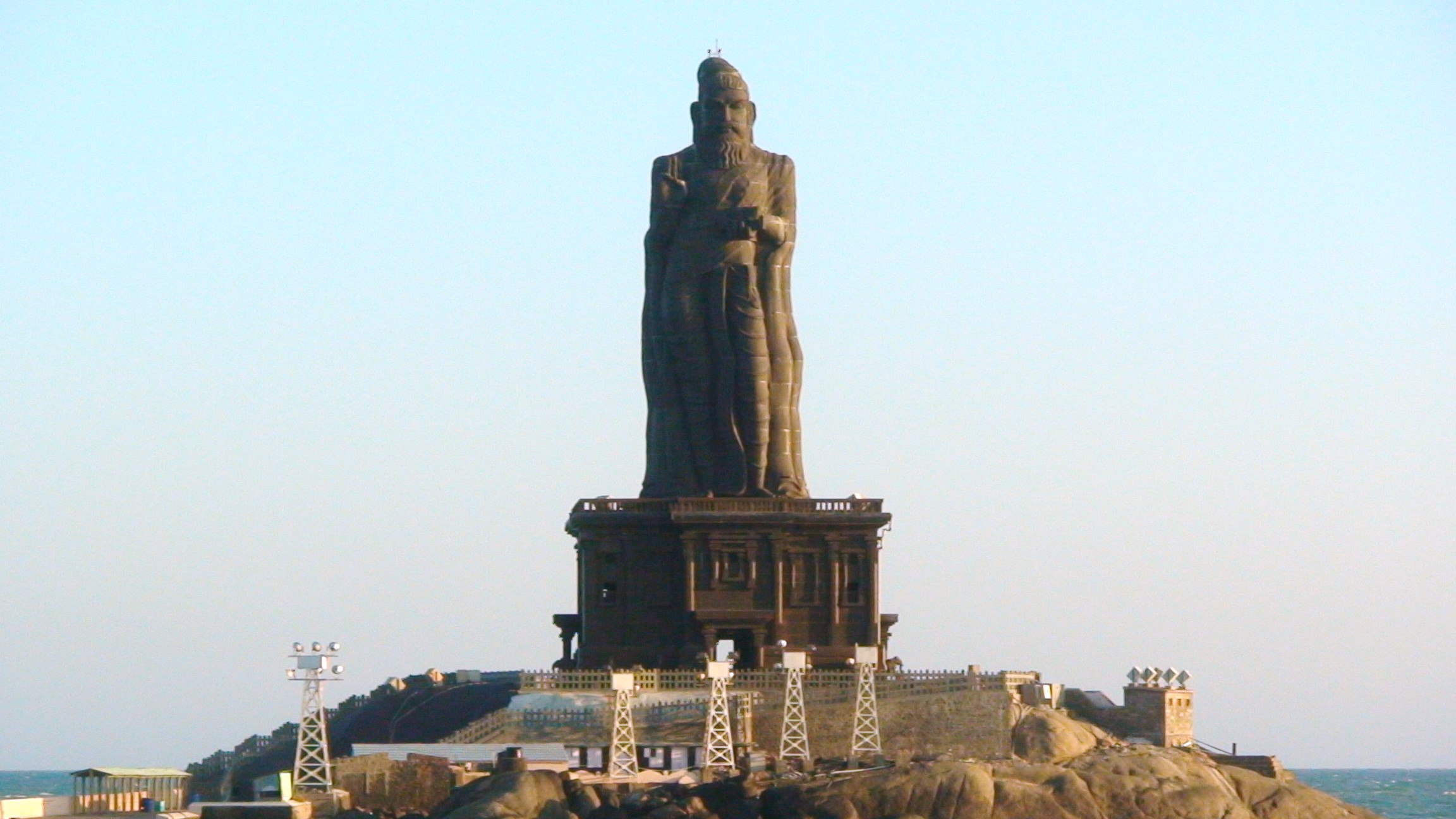
Kanniyakumari (; , referring to Devi Kanya Kumari), also known as Cape Comorin, is a city in Kanniyakumari district in the state of Tamil Nadu, India. It is the southern tip of the Indian subcontinent and the southernmost city in mainland India, thus referred to as 'The Land's End'. The city is situated south of Thiruvananthapuram city, and about south of Nagercoil, the headquarters of Kanniyakumari district. Kanniyakumari is a popular tourist destination and pilgrimage centre in India. Notable tourist spots include its unique sunrise and sunset points, the Thiruvalluvar Statue and Vivekananda Rock Memorial off the coast. Lying at the tip of peninsular India, the town is bordered on the west, south and east by the Laccadive Sea. It has a coastal line of stretched on the three sides. On the shores of the city is a temple dedicated to Goddess Kanniyakumari (the virgin Goddess), after which the town is named.https://thehinduimages.com/details-page.php?id=157918128 ... [...More Info...] [...Related Items...] OR: [Wikipedia] [Google] [Baidu] |
National Highway 47 (India)
National Highway 47 (NH 47) is a primary National Highway in India. It starts from Bamanbore in Gujarat and terminates at Nagpur in Maharashtra. This national highway is about long. Before renumbering of national highways in 2010, NH-47 was variously numbered as old national highways 8A, 59, 59A & 69. Route NH47 transits through three states of India namely Gujarat, Madhya Pradesh and Maharashtra. ;Gujarat Bamanbore, Limbdi, Ahmedabad, Godhra, Dahod - M.P. border ;Madhya Pradesh Gujarat border - Indore, Betul - Maharashtra border ;Maharashtra M.P. border - Saoner, Nagpur Junctions : Terminal near Bamanbore. : near Limbdi : near Sarkhej : near Ahmedabad : near Ahmedabad : near Limkheda : near Dahod : near Jhabua : near Dhar : near Indore : near indore : near Kheri : near Betul : near Betul : near Multai : near Multai : near Saoner : near Saoner : near Saoner : near Dahegaon : near Nagpur : Terminal near Nagpur. See also * List of National Hi ... [...More Info...] [...Related Items...] OR: [Wikipedia] [Google] [Baidu] |
Walayar
Walayar is a border town, located in the eastern corner of Palakkad district in Kerala, India. Geography Walayar lies on the border between Kerala and Tamil Nadu on National Highway 544 (NH544) (NH 47 old). Most of the goods imported into Kerala come by road and predominantly on this road. Due to its traffic volume, the route once had notorious traffic jams. But this changed with the improvement of NH 47 from Walayar to Vadakkanchery. It now has four lanes, with service roads and other facilities. There is an exclusive service road for goods vehicles from the entry point of the check post to the exit point so that passenger vehicles can easily pass through the check post area without any interruption. Widening of NH 47 completed in 2015. Most of the passenger vehicles from other states, such as buses, tourist cabs, and pilgrims, enter Kerala through this gateway. Walayar is considered the Gateway of Kerala from mainland India. Checkposts Commercial tax (previously sales tax) ... [...More Info...] [...Related Items...] OR: [Wikipedia] [Google] [Baidu] |
India
India, officially the Republic of India (Hindi: ), is a country in South Asia. It is the seventh-largest country by area, the second-most populous country, and the most populous democracy in the world. Bounded by the Indian Ocean on the south, the Arabian Sea on the southwest, and the Bay of Bengal on the southeast, it shares land borders with Pakistan to the west; China, Nepal, and Bhutan to the north; and Bangladesh and Myanmar to the east. In the Indian Ocean, India is in the vicinity of Sri Lanka and the Maldives; its Andaman and Nicobar Islands share a maritime border with Thailand, Myanmar, and Indonesia. Modern humans arrived on the Indian subcontinent from Africa no later than 55,000 years ago., "Y-Chromosome and Mt-DNA data support the colonization of South Asia by modern humans originating in Africa. ... Coalescence dates for most non-European populations average to between 73–55 ka.", "Modern human beings—''Homo sapiens''—originated in Africa. Then, int ... [...More Info...] [...Related Items...] OR: [Wikipedia] [Google] [Baidu] |
Trivandrum District
Thiruvananthapuram District (), is the southernmost district in the Indian state of Kerala. The district was created in 1949, with its headquarters in the city of Thiruvananthapuram, which is also Kerala's administrative centre. The present district was created in 1956 by separating the four southernmost Taluks of the erstwhile district to form Kanyakumari district. The city of Thiruvananthapuram is also known as the Information technology capital of the State, since it is home to the first and largest IT park in India, Technopark, established in 1990. The district is home to more than 9% of total population of the state. The district covers an area of . At the 2011 census, it had a population of 3,301,427, making it the second most populous district in Kerala after Malappuram district. Its population density is the highest in Kerala, with . The district is divided into six subdistricts: Thiruvananthapuram, Chirayinkeezhu, Neyyattinkara, Nedumangadu, Varkala, and Kattakada ... [...More Info...] [...Related Items...] OR: [Wikipedia] [Google] [Baidu] |


.jpg)
