|
Altiplano Cundiboyacense
The Altiplano Cundiboyacense () is a high plateau located in the Eastern Cordillera of the Colombian Andes covering parts of the departments of Cundinamarca and Boyacá. (Do not confuse with The Altiplano or the Altiplano Nariñense, both further south.) The altiplano corresponds to the ancient territory of the Muisca. The Altiplano Cundiboyacense comprises three distinctive flat regions; the Bogotá savanna, the valleys of Ubaté and Chiquinquirá, and the valleys of Duitama and Sogamoso. The average altitude of the altiplano is about above sea level but ranges from roughly to . Etymology ''Altiplano'' in Spanish means "high plain" or "high plateau", the second part is a combination of the departments Cundinamarca and Boyacá. Geography The limits of the Altiplano are not strictly defined. The high plateau is enclosed by the higher mountains of the Eastern Ranges, with the Sumapaz mountains in the south and Chingaza to the east. The Tenza Valley is locate ... [...More Info...] [...Related Items...] OR: [Wikipedia] [Google] [Baidu] |
Plateau
In geology and physical geography, a plateau (; ; : plateaus or plateaux), also called a high plain or a tableland, is an area of a highland consisting of flat terrain that is raised sharply above the surrounding area on at least one side. Often one or more sides have deep hills or escarpments. Plateaus can be formed by a number of processes, including upwelling of volcanic magma, extrusion of lava, and erosion by water and glaciers. Plateaus are classified according to their surrounding environment as intermontane, piedmont, or continental. A few plateaus may have a small flat top while others have wider ones. Formation Plateaus can be formed by a number of processes, including upwelling of volcanic magma, extrusion of lava, plate tectonics movements, and erosion by water and glaciers. Volcanic Volcanic plateaus are produced by volcanic activity. They may be formed by upwelling of volcanic magma or extrusion of lava. The underlining mechanism in forming p ... [...More Info...] [...Related Items...] OR: [Wikipedia] [Google] [Baidu] |
Ubaté
Ubaté (originally Villa San Diego de Ubaté) is a town and municipality in the Ubaté Province, part of Cundinamarca Department, Colombia. Ubaté is the capital of the province with the same name and situated in the Ubaté–Chiquinquirá Valley of the Altiplano Cundiboyacense. The urban centre is located at an altitude of and from the capital Bogotá. The province borders the department of Boyacá in the north, the Rionegro Province in the west, the Central Savanna Province in the south and in the east and southeast the Almeidas Province.Official website Ubaté Etymology The name Ubaté comes from the native name "Ebate" meaning "Bloodied land" or "Sower of the mouth".History The area of Ubaté before the[...More Info...] [...Related Items...] OR: [Wikipedia] [Google] [Baidu] |
Hail
Hail is a form of solid Precipitation (meteorology), precipitation. It is distinct from ice pellets (American English "sleet"), though the two are often confused. It consists of balls or irregular lumps of ice, each of which is called a hailstone. Ice pellets generally fall in cold weather, while hail growth is greatly inhibited during low surface temperatures. Unlike other forms of ice, water ice precipitation, such as graupel (which is made of rime ice), ice pellets (which are smaller and Transparency and translucency, translucent), and snow (which consists of tiny, delicately crystalline flakes or needles), hailstones usually measure between and in diameter. The METAR reporting code for hail or greater is GR, while smaller hailstones and graupel are coded GS. Hail is possible during most thunderstorms (as it is produced by cumulonimbus), as well as within of the parent storm. Hail formation requires environments of strong, upward motion of air within the parent thunderst ... [...More Info...] [...Related Items...] OR: [Wikipedia] [Google] [Baidu] |
Iraca
The ''iraca'', sometimes spelled ''iraka'',Ocampo López, 2013, Ch.12, p.77Ocampo López, 2013, Ch.14, p.85 was the ruler and high priest of Sugamuxi in the confederation of the Muisca who inhabited the Altiplano Cundiboyacense; the central highlands of the Colombian Andes. ''Iraca'' can also refer to the Iraka Valley over which they ruled. Important scholars who wrote about the ''iraca'' were Lucas Fernández de Piedrahita, Alexander von Humboldt and Ezequiel Uricoechea. Background In the centuries before the Spanish conquistadores entered central Colombia in the 1530s, the valleys of the Eastern Ranges were ruled by four main leaders and several independent ''caciques''. The northern territories were ruled by the '' zaque'' from Hunza, the present-day capital of Boyacá department and the southern area under the reign of the ''zipa'', based in Bacatá, currently known as the Colombian capital Bogotá. Other important rulers were the ''iraca'' and the ''cacique'' Tund ... [...More Info...] [...Related Items...] OR: [Wikipedia] [Google] [Baidu] |
Chicamocha Canyon
The Chicamocha Canyon ( , ) is a steep sided canyon carved by the Chicamocha River in Colombia. With a maximum depth of , an area of and a length of , the canyon is the second-largest worldwide. The canyon is situated in the departments of Boyacá and Santander, stretching from Soatá in the southeast to Girón and Betulia in the northwest. The canyon is a major tourist attraction at approximately from the capital of Santander, Bucaramanga and close to backpacker destination San Gil. National Route 45A, connecting Bogotá with Bucaramanga, between San Gil and Piedecuesta crosses the canyon and offers spectacular sights on both sides of the Chicamocha River. The heavy truck traffic through the canyon, with frequent accidents and very restricted access can lead to long traffic jams. The canyon is currently administered by Chicamocha National Park ('', PANACHI''). The Chicamocha Canyon started forming in the Early Oligocene, when Colombia was undergoing a tectonically ac ... [...More Info...] [...Related Items...] OR: [Wikipedia] [Google] [Baidu] |
Ocetá Páramo
The Ocetá Páramo (Spanish: ''Páramo de Ocetá'') is a páramo, which means an ecosystem above the continuous forest line yet below the permanent snowline. This particular páramo is located at altitudes between and in the Eastern Ranges of the Colombian Andes. It covers parts of the municipalities Monguí, Mongua and Tópaga, belonging to the Sugamuxi Province, Boyacá. The Ocetá Páramo is known for its collection of small shrubs called frailejones, as well as other Andean flora and fauna. Hiking tours from Monguí or Mongua to the páramo take a full day. The Páramo de Ocetá in the times before the Spanish conquest of the Muisca was inhabited by the Muisca, loyal to the ''iraca'' of Suamox, who considered the region sacred. Myths and legends exist from pre-Columbian and Spanish colonial times and in the lower part of the páramo the Muisca women gave birth in little man-made pools (''Tortolitas''). The Ocetá Páramo is considered the most beautiful páramo i ... [...More Info...] [...Related Items...] OR: [Wikipedia] [Google] [Baidu] |
Tenza Valley
The Tenza Valley (Spanish language, Spanish: ''Valle de Tenza'') is an intermontane valley in the Cordillera Oriental (Colombia), Eastern Ranges of the Colombian Andes. The valley stretches over the southeastern part of the departments of Colombia, department of Boyacá Department, Boyacá and the northeastern part of Cundinamarca Department, Cundinamarca. It is located east of the Altiplano Cundiboyacense and in the time before the Spanish conquest of the Muisca, as the Altiplano was inhabited by the Muisca people, Muisca in the higher altitudes and the Tegua people, Tegua in the lower areas to the east. Etymology The Tenza Valley is named after Tenza which means in Chibcha language, Chibcha: "Behind the mouth" or "Going down at night".Etymology Tenza - Excelsio.net Geography and geology ...
|
Chingaza Natural National Park
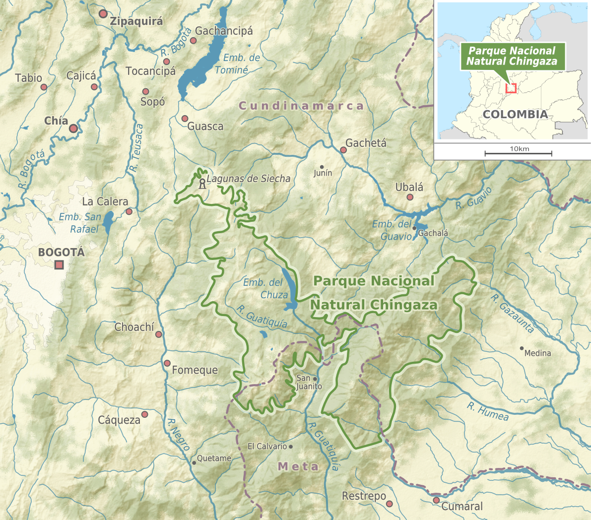
Chingaza National Natural Park () is located in the Eastern Ranges of the Colombian Andes, northeast of Bogotá, Colombia in the departments of Cundinamarca and Meta. The elevation in the park, to the east of the Altiplano Cundiboyacense, ranges from , and the temperature ranges from .Website Chingaza Natural National Park - accessed 06-05-2016 The park extends over the Cundinamarca municipalities La Calera, Fómeque, Guasca and San Juanito ( |
Sumapaz
Sumapaz is the 20th locality of Bogotá, capital of Colombia. It is the largest of Bogotá's 20 localities, starting in the north at the edge of the urban frontier with Usme and stretching to the south at the border of Cundinamarca with the departments of Meta and Huila. It is completely rural, with no city services. History The Sumapaz Páramo, covering most of the locality, was a sacred site for the indigenous Muisca in pre-Columbian times. In the 16th century, it was discovered by conquistadors led by Nicolaus Federmann in their quest for ''El Dorado''. It has been the stage for several rural conflicts, including those of 1928 and 1946. La Violencia of 1948 gave rise to the formation of the guerrilla groups still present in Colombia. At the beginning of the 21st century, the Colombian army took the territory from guerrilla hands as part of a counter-guerrilla strategy of president Álvaro Uribe. Economy The population is dependent on small-scale farming and livestock. ... [...More Info...] [...Related Items...] OR: [Wikipedia] [Google] [Baidu] |
Altiplano Cundiboyacense (subdivisions)
The Altiplano Cundiboyacense () is a high plateau located in the Eastern Cordillera of the Colombian Andes covering parts of the departments of Cundinamarca and Boyacá. (Do not confuse with The Altiplano or the Altiplano Nariñense, both further south.) The altiplano corresponds to the ancient territory of the Muisca. The Altiplano Cundiboyacense comprises three distinctive flat regions; the Bogotá savanna, the valleys of Ubaté and Chiquinquirá, and the valleys of Duitama and Sogamoso. The average altitude of the altiplano is about above sea level but ranges from roughly to . Etymology ''Altiplano'' in Spanish means "high plain" or "high plateau", the second part is a combination of the departments Cundinamarca and Boyacá. Geography The limits of the Altiplano are not strictly defined. The high plateau is enclosed by the higher mountains of the Eastern Ranges, with the Sumapaz mountains in the south and Chingaza to the east. The Tenza Valley is located to the e ... [...More Info...] [...Related Items...] OR: [Wikipedia] [Google] [Baidu] |
Departments Of Colombia
Colombia is a unitary state, unitary republic made up of thirty-two administrative divisions referred to as departments (Spanish language, Spanish: ''departamentos'', sing. ) and one Capital District (''Capital districts and territories, Distrito Capital''). Departments are administrative division, country subdivisions and are granted a certain degree of autonomy. Each department has a governor (''gobernador'') and an Assembly (''Asamblea Departamental''), elected by popular vote for a four-year period. The governor cannot be re-elected in consecutive periods. Departments are formed by a grouping of municipalities of Colombia, municipalities (''municipios'', sing. ''municipio''). Municipal government is headed by mayor (''alcalde'') and administered by a municipal council (''concejo municipal''), both of which are elected by popular vote for four-year periods. Internal subdivisions within departments The current borders and number of the departments of Colombia was finally se ... [...More Info...] [...Related Items...] OR: [Wikipedia] [Google] [Baidu] |
Spanish Language
Spanish () or Castilian () is a Romance languages, Romance language of the Indo-European languages, Indo-European language family that evolved from the Vulgar Latin spoken on the Iberian Peninsula of Europe. Today, it is a world language, global language with 483 million native speakers, mainly in the Americas and Spain, and about 558 million speakers total, including second-language speakers. Spanish is the official language of List of countries where Spanish is an official language, 20 countries, as well as one of the Official languages of the United Nations, six official languages of the United Nations. Spanish is the world's list of languages by number of native speakers, second-most spoken native language after Mandarin Chinese; the world's list of languages by total number of speakers, fourth-most spoken language overall after English language, English, Mandarin Chinese, and Hindustani language, Hindustani (Hindi-Urdu); and the world's most widely spoken Romance language ... [...More Info...] [...Related Items...] OR: [Wikipedia] [Google] [Baidu] |


