|
Alteckendorf
Alteckendorf (; sometimes spelled ''Alt Eckendorf''; gsw-FR, Àltackedorf) is a commune in the Bas-Rhin department in the Grand Est region of northeastern France. The inhabitants of the commune are known as ''Alteckendorfois'' or ''Alteckendorfoises''. Geography Alteckendorf is about 30 km north-west of Strasbourg and 20 km east of Saverne. Covering an area of 572 hectares, the commune is located on the plain of Alsace and more specifically in the area of some loess hills behind Kochersberg and between the Vosges Mountains and Germany. The town is located 177 metres above sea level and is watered by the ''Landgraben'' stream, a tributary of the Zorn. It is surrounded by the ''Koppenberg'' (256 metres), ''Englischberg'' (288 metres), and ''Schyrberg'' (250 metres) hills. To the north of the town is the Alteckendorf forest. The Sarreguemines-Strasbourg railway runs through the commune with a station on the south-east edge of the village. Neighbouring localities withi ... [...More Info...] [...Related Items...] OR: [Wikipedia] [Google] [Baidu] |
Communes Of France
The () is a level of administrative division in the French Republic. French are analogous to civil townships and incorporated municipalities in the United States and Canada, ' in Germany, ' in Italy, or ' in Spain. The United Kingdom's equivalent are civil parishes, although some areas, particularly urban areas, are unparished. are based on historical geographic communities or villages and are vested with significant powers to manage the populations and land of the geographic area covered. The are the fourth-level administrative divisions of France. vary widely in size and area, from large sprawling cities with millions of inhabitants like Paris, to small hamlets with only a handful of inhabitants. typically are based on pre-existing villages and facilitate local governance. All have names, but not all named geographic areas or groups of people residing together are ( or ), the difference residing in the lack of administrative powers. Except for the municipal arrondi ... [...More Info...] [...Related Items...] OR: [Wikipedia] [Google] [Baidu] |
Lixhausen
Lixhausen (; gsw-als, Líxhüse) is a commune in the Bas-Rhin department in Grand Est in north-eastern France. See also * Communes of the Bas-Rhin department The following is a list of the 514 communes of the Bas-Rhin department of France. The communes cooperate in the following intercommunalities (as of 2020):Communes of Bas-Rhin {{BasRhin-geo-stub ... [...More Info...] [...Related Items...] OR: [Wikipedia] [Google] [Baidu] |
Grassendorf
Grassendorf (; gsw-FR, Gràssedorf) is a commune in the Bas-Rhin department in Grand Est in north-eastern France. History Following the Thirty Years War which badly depleted population levels in much of Alsace, a large number of immigrants arrived from the Thiérache region of Picardy during the middle of the seventeenth century. In the local language the inhabitants of Grassendorf are known as "Welschguller" which means something along the lines of "foreign turkeys". Until the 1990s the spire of the parish church was topped off by the carving of a turkey rather than of the Gallic rooster which is more normally found on the tops of church spires in rural France. See also * Communes of the Bas-Rhin department The following is a list of the 514 communes of the Bas-Rhin department of France. The communes cooperate in the following intercommunalities (as of 2020): [...More Info...] [...Related Items...] OR: [Wikipedia] [Google] [Baidu] |
Zorn (river)
The Zorn is a river that flows through the Lorraine (region), Lorraine and the Alsace as the largest and last of the tributaries of the river Moder (river), Moder, before the latter empties into the Rhine. It rises on the territory of Walscheid as the Yellow Zorn (German: ''Gelber Zorn'', French: ''Zorn Jaune'') and becomes the Zorn after its confluence with the right-hand tributary, the White Zorn (Ge: ''Weißer Zorn'', Fr.: ''Zorn Blanche''). It has a length of just under 97The figures on river length are based on the information about the , retrieved 27 August 2011, rounded to whole kilometres. kilometres and drains an area of 757 km². The French language, French spelling Zorn first surfaced in the 18th century. Hitherto the river was called the ''Sorn'', which stems from the pre-Celtic era and probably meant "the flowing one".Albrecht Greule: ''Vor- und frühgermanische Flußnamen am Oberrhein'', Heidelberg, 1973, p. 97 , zugl. Diss. of the University of Freiburg/Br. 1971 T ... [...More Info...] [...Related Items...] OR: [Wikipedia] [Google] [Baidu] |
Foehn Effect
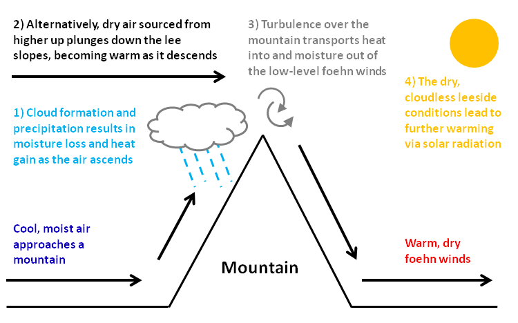
A Foehn or Föhn (, , ), is a type of dry, relatively warm, downslope wind that occurs in the lee (downwind side) of a mountain range. It is a rain shadow wind that results from the subsequent adiabatic warming of air that has dropped most of its moisture on windward slopes (see orographic lift). As a consequence of the different adiabatic lapse rates of moist and dry air, the air on the leeward slopes becomes warmer than equivalent elevations on the windward slopes. Foehn winds can raise temperatures by as much as 14 °C (25 °F) in just a matter of hours. Switzerland, southern Germany and Austria have a warmer climate due to the Foehn, as moist winds off the Mediterranean Sea blow over the Alps. Etymology The name ''Foehn'' (german: Föhn, ) arose in the Alpine region. Originating from Latin ''(ventus) favonius'', a mild west wind of which Favonius was the Roman personification and probably transmitted by rm, favuogn or just ''fuogn'', the term was adopted as ... [...More Info...] [...Related Items...] OR: [Wikipedia] [Google] [Baidu] |
Black Forest
The Black Forest (german: Schwarzwald ) is a large forested mountain range in the state of Baden-Württemberg in southwest Germany, bounded by the Rhine Valley to the west and south and close to the borders with France and Switzerland. It is the source of the Danube and Neckar rivers. Its highest peak is the Feldberg with an elevation of above sea level. Roughly oblong in shape, with a length of and breadth of up to , it has an area of about 6,009 km2 (2,320 sq mi). Historically, the area was known for forestry and the mining of ore deposits, but tourism has now become the primary industry, accounting for around 300,000 jobs. There are several ruined military fortifications dating back to the 17th century. History In ancient times, the Black Forest was known as , after the Celtic deity, Abnoba. In Roman times (Late antiquity), it was given the name ("Marcynian Forest", from the Germanic word ''marka'' = "border"). The Black Forest probably represented the bo ... [...More Info...] [...Related Items...] OR: [Wikipedia] [Google] [Baidu] |
Buswiller
Buswiller (; ) is a commune in the Bas-Rhin department in Grand Est in north-eastern France. See also * Communes of the Bas-Rhin department The following is a list of the 514 communes of the Bas-Rhin department of France. The communes cooperate in the following intercommunalities (as of 2020):Communes of Bas-Rhin Bas-Rhin communes articles needing translation from French Wikipedia {{BasRhin-geo-stub ... [...More Info...] [...Related Items...] OR: [Wikipedia] [Google] [Baidu] |
TER Grand Est
TER Grand Est or TER Fluo is the regional rail network serving the region of Grand Est, northeastern France. It is operated by the French national railway company SNCF. It was formed in 2016 from the previous TER networks TER Alsace, TER Lorraine and TER Champagne-Ardenne, when the respective regions were merged. History On 1st January 2016, the three administrative regions of Alsace, Lorraine and Champagne-Ardenne merged. As a result, on 11 December 2016, TER Grand Est was created out of the three existing systems TER Alsace, TER Lorraine and TER Champagne-Ardenne, including TER 200 and TER Vallée de la Marne. In spring 2019, TER Grand Est was integrated into the intermodal network Fluo Grand Est. The new branding is used to signify TER train services operated in the region. Network The rail and bus network as of February 2021: [...More Info...] [...Related Items...] OR: [Wikipedia] [Google] [Baidu] |
SNCF
The Société nationale des chemins de fer français (; abbreviated as SNCF ; French for "National society of French railroads") is France's national state-owned railway company. Founded in 1938, it operates the country's national rail traffic along with Monaco, including the TGV, on France's high-speed rail network. Its functions include operation of railway services for passengers and freight (through its subsidiaries SNCF Voyageurs and Rail Logistics Europe), as well as maintenance and signalling of rail infrastructure (SNCF Réseau). The railway network consists of about of route, of which are high-speed lines and electrified. About 14,000 trains are operated daily. In 2010 the SNCF was ranked 22nd in France and 214th globally on the Fortune Global 500 list. It is the main business of the SNCF Group, which in 2020 had €30 billion of sales in 120 countries. The SNCF Group employs more than 275,000 employees in France and around the world. Since July 2013, the SNCF Grou ... [...More Info...] [...Related Items...] OR: [Wikipedia] [Google] [Baidu] |
Car-pooling
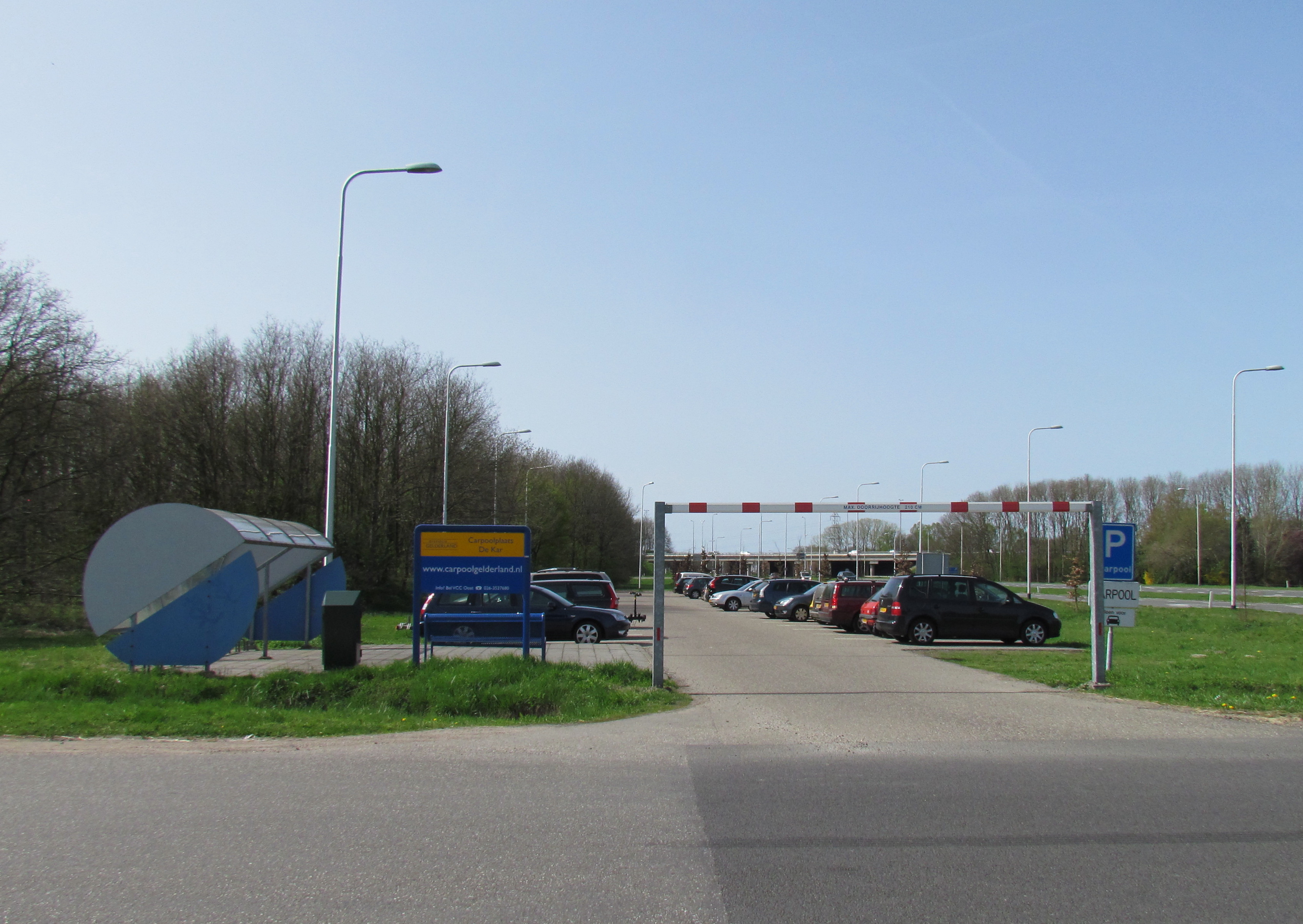
Carpooling (also car-sharing, ride-sharing and lift-sharing) is the sharing of Automobile, car journeys so that more than one person travels in a car, and prevents the need for others to have to drive to a location themselves. By having more people using one vehicle, carpooling reduces each person's travel costs such as: Gasoline and diesel usage and pricing, fuel costs, toll road, tolls, and the stress of driving. Carpooling is also a more environmentally friendly and sustainable way to travel as sharing journeys reduces air pollution, carbon emissions, traffic congestion on the roads, and the need for parking spaces. Authorities often encourage carpooling, especially during periods of high pollution or high fuel prices. Car sharing is a good way to use up the full seating capacity of a car, which would otherwise remain unused if it were just the driver using the car. In 2009, carpooling represented 43.5% of all trips in the United States and 10% of commute trips. The major ... [...More Info...] [...Related Items...] OR: [Wikipedia] [Google] [Baidu] |


