|
Albedo
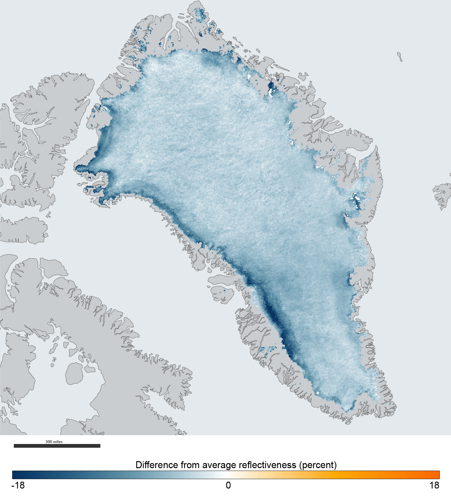
Albedo ( ; ) is the fraction of sunlight that is Diffuse reflection, diffusely reflected by a body. It is measured on a scale from 0 (corresponding to a black body that absorbs all incident radiation) to 1 (corresponding to a body that reflects all incident radiation). ''Surface albedo'' is defined as the ratio of Radiosity (radiometry), radiosity ''J''e to the irradiance ''E''e (flux per unit area) received by a surface. The proportion reflected is not only determined by properties of the surface itself, but also by the spectral and angular distribution of solar radiation reaching the Earth's surface. These factors vary with atmospheric composition, geographic location, and time (see position of the Sun). While directional-hemispherical reflectance factor is calculated for a single angle of incidence (i.e., for a given position of the Sun), albedo is the directional integration of reflectance over all solar angles in a given period. The temporal resolution may range from seconds ... [...More Info...] [...Related Items...] OR: [Wikipedia] [Google] [Baidu] [Amazon] |
Bidirectional Reflectance Distribution Function
The bidirectional reflectance distribution function (BRDF), symbol f_(\omega_,\, \omega_), is a function of four real variables that defines how light from a source is reflected off an Opacity (optics), opaque surface. It is employed in the optics of real-world light, in computer graphics algorithms, and in computer vision algorithms. The function takes an incoming light direction, \omega_, and outgoing direction, \omega_ (taken in a coordinate system where the Normal (geometry), surface normal \mathbf n lies along the ''z''-axis), and returns the ratio of reflected radiance exiting along \omega_ to the irradiance incident on the surface from direction \omega_. Each direction \omega is itself Spherical coordinate system, parameterized by azimuth angle \phi and zenith angle \theta, therefore the BRDF as a whole is a function of 4 variables. The BRDF has units sr−1, with steradians (sr) being a unit of solid angle. Definition The BRDF was first defined by Fred Nicodemus around 19 ... [...More Info...] [...Related Items...] OR: [Wikipedia] [Google] [Baidu] [Amazon] |
Ice–albedo Feedback
Ice–albedo feedback is a climate change feedback, where a change in the area of ice caps, glaciers, and sea ice alters the albedo and surface temperature of a planet. Because ice is very reflective, it reflects far more solar energy back to space than open water or any other land cover. It occurs on Earth, and can also occur on exoplanets. Since higher latitudes have the coolest temperatures, they are the most likely to have perennial snow cover, widespread glaciers and ice caps - up to and including the potential to form ice sheets. However, if warming occurs, then higher temperatures would decrease ice-covered area, and expose more open water or land. The albedo decreases, and so more solar energy is absorbed, leading to more warming and greater loss of the reflective parts of the cryosphere. Inversely, cooler temperatures increase ice cover, which increases albedo and results in greater cooling, which makes further ice formation more likely. Thus, ice–albedo feedback plays ... [...More Info...] [...Related Items...] OR: [Wikipedia] [Google] [Baidu] [Amazon] |
Directional-hemispherical Reflectance
Directional-hemispherical reflectance is the reflectance of a surface under direct illumination (with no diffuse component). Directional-hemispherical reflectance is the integral of the bidirectional reflectance distribution function over all viewing directions. It is sometimes called "black-sky albedo Albedo ( ; ) is the fraction of sunlight that is Diffuse reflection, diffusely reflected by a body. It is measured on a scale from 0 (corresponding to a black body that absorbs all incident radiation) to 1 (corresponding to a body that reflects ...". References See also * Bi-hemispherical reflectance Electromagnetic radiation Climatology {{Optics-stub ... [...More Info...] [...Related Items...] OR: [Wikipedia] [Google] [Baidu] [Amazon] |
Climate Change
Present-day climate change includes both global warming—the ongoing increase in Global surface temperature, global average temperature—and its wider effects on Earth's climate system. Climate variability and change, Climate change in a broader sense also includes previous long-term changes to Earth's climate. The current rise in global temperatures is Scientific consensus on climate change, driven by human activities, especially fossil fuel burning since the Industrial Revolution. Fossil fuel use, Deforestation and climate change, deforestation, and some Greenhouse gas emissions from agriculture, agricultural and Environmental impact of concrete, industrial practices release greenhouse gases. These gases greenhouse effect, absorb some of the heat that the Earth Thermal radiation, radiates after it warms from sunlight, warming the lower atmosphere. Carbon dioxide, the primary gas driving global warming, Carbon dioxide in Earth's atmosphere, has increased in concentratio ... [...More Info...] [...Related Items...] OR: [Wikipedia] [Google] [Baidu] [Amazon] |
Climate Change (general Concept)
Present-day climate change includes both global warming—the ongoing increase in global average temperature—and its wider effects on Earth's climate system. Climate change in a broader sense also includes previous long-term changes to Earth's climate. The current rise in global temperatures is driven by human activities, especially fossil fuel burning since the Industrial Revolution. Fossil fuel use, deforestation, and some agricultural and industrial practices release greenhouse gases. These gases absorb some of the heat that the Earth radiates after it warms from sunlight, warming the lower atmosphere. Carbon dioxide, the primary gas driving global warming, has increased in concentration by about 50% since the pre-industrial era to levels not seen for millions of years. Climate change has an increasingly large impact on the environment. Deserts are expanding, while heat waves and wildfires are becoming more common. Amplified warming in the Arctic has cont ... [...More Info...] [...Related Items...] OR: [Wikipedia] [Google] [Baidu] [Amazon] |
MODIS
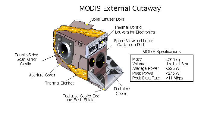
The Moderate Resolution Imaging Spectroradiometer (MODIS) is a satellite-based sensor used for earth and climate measurements. There are two MODIS sensors in Earth orbit: one on board the Terra (EOS AM) satellite, launched by NASA in 1999; and one on board the Aqua (EOS PM) satellite, launched in 2002. Since 2011, MODIS operations have been supplemented by VIIRS sensors, such as the one aboard Suomi NPP. The systems often conduct similar operations due to their similar designs and orbits (with VIIRS data systems deisgned to be compatible with MODIS), though they have subtle differences contributing to similar but not identical uses. The MODIS instruments were built by Santa Barbara Remote Sensing. They capture data in 36 spectral bands ranging in wavelength from 0.4 μm to 14.4 μm and at varying spatial resolutions (2 bands at 250 m, 5 bands at 500 m and 29 bands at 1 km). Together the instruments image the entire Earth every 1 to 2 days. They are designed ... [...More Info...] [...Related Items...] OR: [Wikipedia] [Google] [Baidu] [Amazon] |
Sea Ice
Sea ice arises as seawater freezes. Because ice is less density, dense than water, it floats on the ocean's surface (as does fresh water ice). Sea ice covers about 7% of the Earth's surface and about 12% of the world's oceans. Much of the world's sea ice is enclosed within the polar ice packs in the Earth's polar regions: the Arctic ice pack of the Arctic Ocean and the Antarctic ice pack of the Southern Ocean. Polar packs undergo a significant yearly cycling in surface extent, a natural process upon which depends the Arctic ecology, including the Arctic sea ice ecology and history, ocean's ecosystems. Due to the action of winds, currents and temperature fluctuations, sea ice is very dynamic, leading to a wide variety of ice types and features. Sea ice may be contrasted with icebergs, which are chunks of ice shelf, ice shelves or glaciers that Ice calving, calve into the ocean. Depending on location, sea ice expanses may also incorporate icebergs. General features and dynamics ... [...More Info...] [...Related Items...] OR: [Wikipedia] [Google] [Baidu] [Amazon] |
Solar Zenith Angle
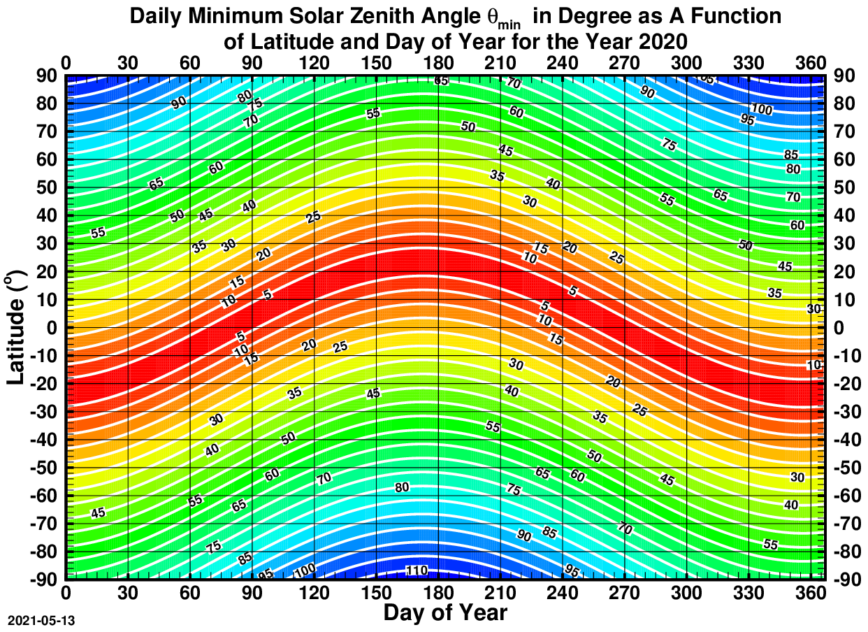
The solar zenith angle is the zenith angle of the sun, i.e., the angle between the sun’s rays and the vertical direction. It is the complement to the solar altitude or solar elevation, which is the altitude angle or elevation angle between the sun’s rays and a horizontal plane. At solar noon, the altitude angle (complement of the solar angle) is at a minimum and is equal to latitude minus solar declination angle. This is the basis by which ancient mariners navigated the oceans. Solar zenith angle is normally used in combination with the solar azimuth angle to determine the position of the Sun as observed from a given location on the surface of the Earth. Formula \cos \theta_s = \sin \alpha_s = \sin \Phi \sin \delta + \cos \Phi \cos \delta \cos h where * \theta_s is the ''solar zenith angle'' * \alpha_s is the ''solar altitude angle'', \alpha_s = 90^\circ - \theta_s * h is the hour angle, in the local solar time. * \delta is the current declination of the Sun * \Phi is the ... [...More Info...] [...Related Items...] OR: [Wikipedia] [Google] [Baidu] [Amazon] |
Reflectance
The reflectance of the surface of a material is its effectiveness in reflecting radiant energy. It is the fraction of incident electromagnetic power that is reflected at the boundary. Reflectance is a component of the response of the electronic structure of the material to the electromagnetic field of light, and is in general a function of the frequency, or wavelength, of the light, its polarization, and the angle of incidence. The dependence of reflectance on the wavelength is called a ''reflectance spectrum'' or ''spectral reflectance curve''. Mathematical definitions Hemispherical reflectance The ''hemispherical reflectance'' of a surface, denoted , is defined as R = \frac, where is the radiant flux ''reflected'' by that surface and is the radiant flux ''received'' by that surface. Spectral hemispherical reflectance The ''spectral hemispherical reflectance in frequency'' and ''spectral hemispherical reflectance in wavelength'' of a surface, denoted and respectively, are ... [...More Info...] [...Related Items...] OR: [Wikipedia] [Google] [Baidu] [Amazon] |
Irradiance
In radiometry, irradiance is the radiant flux ''received'' by a ''surface'' per unit area. The SI unit of irradiance is the watt per square metre (symbol W⋅m−2 or W/m2). The CGS unit erg per square centimetre per second (erg⋅cm−2⋅s−1) is often used in astronomy. Irradiance is often called intensity, but this term is avoided in radiometry where such usage leads to confusion with radiant intensity. In astrophysics, irradiance is called ''radiant flux''. Spectral irradiance is the irradiance of a surface per unit frequency or wavelength, depending on whether the spectrum is taken as a function of frequency or of wavelength. The two forms have different dimensions and units: spectral irradiance of a frequency spectrum is measured in watts per square metre per hertz (W⋅m−2⋅Hz−1), while spectral irradiance of a wavelength spectrum is measured in watts per square metre per metre (W⋅m−3), or more commonly watts per square metre per nanometre (W⋅m−2⋅nm−1) ... [...More Info...] [...Related Items...] OR: [Wikipedia] [Google] [Baidu] [Amazon] |
Earth Observation
Earth observation (EO) is the gathering of information about the physical, chemical, and biosphere, biological systems of the planet Earth. It can be performed via remote sensing, remote-sensing technologies (Earth observation satellites) or through direct-contact sensors in ground-based or airborne platforms (such as weather stations and weather balloons, for example). According to the Group on Earth Observations (GEO), the concept encompasses both "space-based or remotely-sensed data, as well as ground-based or In situ#Earth and atmospheric sciences, in situ data". Earth observation is used to monitor and assess the status of and changes in natural environment, natural and built environments. Terminology In Europe, ''Earth observation'' has often been used to refer to satellite-based remote sensing, but the term is also used to refer to any form of observations of the Earth system, including in situ and airborne observations, for example. The GEO, which has over 100 member coun ... [...More Info...] [...Related Items...] OR: [Wikipedia] [Google] [Baidu] [Amazon] |
Joint Polar Satellite System
The Joint Polar Satellite System (JPSS) is the latest generation of U.S. polar-orbiting, non-geosynchronous, environmental satellites. JPSS will provide the global environmental data used in numerical weather prediction models for forecasts, and scientific data used for climate monitoring. JPSS will aid in fulfilling the mission of the U.S. National Oceanic and Atmospheric Administration (NOAA), an agency of the Department of Commerce. Data and imagery obtained from the JPSS will increase timeliness and accuracy of public warnings and forecasts of climate and weather events, thus reducing the potential loss of human life and property and advancing the national economy. The JPSS is developed by the National Aeronautics and Space Administration (NASA) for the National Oceanic and Atmospheric Administration (NOAA), who is responsible for operation of JPSS. Three to five satellites are planned for the JPSS constellation of satellites. JPSS satellites will be flown, and the scientific ... [...More Info...] [...Related Items...] OR: [Wikipedia] [Google] [Baidu] [Amazon] |


