|
Akaroa County
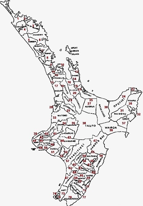
Akaroa County was one of the counties of New Zealand in the South Island. The council first met in Akaroa court house on 4 January 1877. In 1880 new offices were opened at Duvauchelle. It became part of Banks Peninsula District The Banks Peninsula District is a former territorial authority in New Zealand. Banks Peninsula District was formed through the 1989 local government reforms. It amalgamated with the Christchurch City Council in March 2006. It was governed by a m ... in 1989. See also * List of former territorial authorities in New Zealand § Counties References External links 1891 mapList of county archives Counties of New Zealand 1876 establishments in New Zealand 1989 disestablishments in New Zealand {{CanterburyNZ-geo-stub ... [...More Info...] [...Related Items...] OR: [Wikipedia] [Google] [Baidu] |
County (New Zealand)
A system of counties of New Zealand was instituted after the country dissolved its provinces in 1876, and these counties were similar to other countries' systems, lasting with little change (except mergers and other localised boundary adjustments) until 1989, when they were reorganised into district and city councils within a system of larger regions. History The Counties Bill of 1876 was initiated to merge 314 road boards into 39 counties. However, as a result of lobbying the number of counties had grown to 63 by the time the bill was enacted. They had chairmen, not mayors as boroughs and cities had; many legislative provisions (such as burial and land subdivision control) were different for the counties. By 1966, there were 112 counties. During the second half of the 20th century, many counties received overflow population from nearby cities. The result was often a merger of the two into a "district" (e.g., Rotorua) or a change of name to "district" (e.g., Waimairi) or "c ... [...More Info...] [...Related Items...] OR: [Wikipedia] [Google] [Baidu] |
New Zealand
New Zealand ( mi, Aotearoa ) is an island country in the southwestern Pacific Ocean. It consists of two main landmasses—the North Island () and the South Island ()—and over 700 smaller islands. It is the sixth-largest island country by area, covering . New Zealand is about east of Australia across the Tasman Sea and south of the islands of New Caledonia, Fiji, and Tonga. The country's varied topography and sharp mountain peaks, including the Southern Alps, owe much to tectonic uplift and volcanic eruptions. New Zealand's capital city is Wellington, and its most populous city is Auckland. The islands of New Zealand were the last large habitable land to be settled by humans. Between about 1280 and 1350, Polynesians began to settle in the islands and then developed a distinctive Māori culture. In 1642, the Dutch explorer Abel Tasman became the first European to sight and record New Zealand. In 1840, representatives of the United Kingdom and Māori chiefs ... [...More Info...] [...Related Items...] OR: [Wikipedia] [Google] [Baidu] |
Duvauchelle
Duvauchelle Bay ( mi, Kaitouna) is a small town situated at the head of Akaroa Harbour on Banks Peninsula in New Zealand. State Highway 75 passes through the town. The Onawe Peninsula separates Duvauchelle bay from Barry's Bay. Duvauchelle is now part of Christchurch City Council jurisdiction since the city's amalgamation with Banks Peninsula District in 2006. From 1910 until 1989, Duvauchelle was the seat of the Akaroa County Council. History The site of an ancient Māori pā or fortified settlement is at Oinako, where the Duvauchelle Hotel stands today. At Te Wharau creek, a taua or war party of Ngāti Awa warriors camped during the battles led by Te Rauparaha in 1831. The name of the town and bay comes from the surname of two brothers Jules-Augustin and Louis-Benjamin Duvauchelle, who held land there from the Nanto-Bordelaise Company, at the time of the French settlement at Akaroa in the 1840s. In the following decade, land alongside Duvauchelle Bay was leased from the ... [...More Info...] [...Related Items...] OR: [Wikipedia] [Google] [Baidu] |
Christchurch City Council
The Christchurch City Council is the local government authority for Christchurch in New Zealand. It is a territorial authority elected to represent the people of Christchurch. Since October 2022, the Mayor of Christchurch is Phil Mauger, who succeeded after the retirement of Lianne Dalziel. The council currently consists of 16 councillors elected from sixteen wards, and is presided over by the mayor, who is elected at large. The number of elected members and ward boundaries changed prior during the 2016 election. History As a result of the 1989 local government reforms, on 1 November 1989 Christchurch City Council took over the functions of the former Christchurch City Council, Heathcote County Council, Riccarton Borough Council, Waimairi District Council, part of Paparua County Council, and the Christchurch Drainage Board. On 6 March 2006, Banks Peninsula District Council merged with Christchurch City Council. Councillor Yani Johanson campaigned since 2010 to live-strea ... [...More Info...] [...Related Items...] OR: [Wikipedia] [Google] [Baidu] |
Counties Of New Zealand
A system of counties of New Zealand was instituted after the country dissolved its provinces in 1876, and these counties were similar to other countries' systems, lasting with little change (except mergers and other localised boundary adjustments) until 1989, when they were reorganised into district and city councils within a system of larger regions. History The Counties Bill of 1876 was initiated to merge 314 road boards into 39 counties. However, as a result of lobbying the number of counties had grown to 63 by the time the bill was enacted. They had chairmen, not mayors as boroughs and cities had; many legislative provisions (such as burial and land subdivision control) were different for the counties. By 1966, there were 112 counties. During the second half of the 20th century, many counties received overflow population from nearby cities. The result was often a merger of the two into a "district" (e.g., Rotorua) or a change of name to "district" (e.g., Waimairi) or "c ... [...More Info...] [...Related Items...] OR: [Wikipedia] [Google] [Baidu] |
South Island
The South Island, also officially named , is the larger of the two major islands of New Zealand in surface area, the other being the smaller but more populous North Island. It is bordered to the north by Cook Strait, to the west by the Tasman Sea, and to the south and east by the Pacific Ocean. The South Island covers , making it the world's 12th-largest island. At low altitude, it has an oceanic climate. The South Island is shaped by the Southern Alps which run along it from north to south. They include New Zealand's highest peak, Aoraki / Mount Cook at . The high Kaikōura Ranges lie to the northeast. The east side of the island is home to the Canterbury Plains while the West Coast is famous for its rough coastlines such as Fiordland, a very high proportion of native bush and national parks, and the Fox and Franz Josef Glaciers. The main centres are Christchurch and Dunedin. The economy relies on agriculture and fishing, tourism, and general manufacturing and services. ... [...More Info...] [...Related Items...] OR: [Wikipedia] [Google] [Baidu] |
Akaroa
Akaroa is a small town on Banks Peninsula in the Canterbury Region of the South Island of New Zealand, situated within a harbour of the same name. The name Akaroa is Kāi Tahu Māori for "Long Harbour", which would be spelled in standard Māori. The area was also named ''Port Louis-Philippe'' by French settlers after the reigning French king Louis Philippe I. The town is by road from Christchurch and is the terminus of State Highway 75. It is set on a sheltered harbour and is overlooked and surrounded by the remnants of a miocene volcano. Akaroa is entirely dependent upon rainfall on the hills. Akaroa is a popular resort town. Many Hector's dolphins may be found within the harbour, and 'swim with the dolphins' boat tours are a major tourist attraction. Ōnuku marae, a (tribal meeting ground) of Ngāi Tahu and its Ōnuku Rūnanga branch, is located in Akaroa. It includes the Karaweko (meeting house). History In 1830, the Māori settlement at Takapūneke, just east ... [...More Info...] [...Related Items...] OR: [Wikipedia] [Google] [Baidu] |
Banks Peninsula District
The Banks Peninsula District is a former territorial authority in New Zealand. Banks Peninsula District was formed through the 1989 local government reforms. It amalgamated with the Christchurch City Council in March 2006. It was governed by a mayor and district councillors. See also *Districts of New Zealand A district in New Zealand is a territorial authority area governed by a district council as a second-tier of local government in New Zealand, below regional councils. They were formed as a result of the local government reforms in 1989. There are ... References Politics of Canterbury, New Zealand {{NewZealand-poli-stub ... [...More Info...] [...Related Items...] OR: [Wikipedia] [Google] [Baidu] |
List Of Former Territorial Authorities In New Zealand
This is a list of former territorial authorities in New Zealand. "Territorial authority" is the generic term used for local government entities in New Zealand. Local government has gone through three principal phases with different structures: the provincial era, from 1853 to 1876; the counties and boroughs system from 1876 until 1989; and the current system of regions, cities and districts. This article attempts to list all territorial authorities which have been disestablished. Provincial era (until 1876) The original three provinces were established in 1841 by Royal Charter. The New Zealand Constitution Act 1846 reduced the number of provinces to two. The New Zealand Constitution Act 1852 re-divided New Zealand into six provinces, and four additional provinces emerged during the remainder of the Provincial Era. This era came to end with the Abolition of Provinces Act 1876. Post-provincial era (1876–1989) After New Zealand abolished its provinces in 1876, a system of ... [...More Info...] [...Related Items...] OR: [Wikipedia] [Google] [Baidu] |
Counties Of New Zealand
A system of counties of New Zealand was instituted after the country dissolved its provinces in 1876, and these counties were similar to other countries' systems, lasting with little change (except mergers and other localised boundary adjustments) until 1989, when they were reorganised into district and city councils within a system of larger regions. History The Counties Bill of 1876 was initiated to merge 314 road boards into 39 counties. However, as a result of lobbying the number of counties had grown to 63 by the time the bill was enacted. They had chairmen, not mayors as boroughs and cities had; many legislative provisions (such as burial and land subdivision control) were different for the counties. By 1966, there were 112 counties. During the second half of the 20th century, many counties received overflow population from nearby cities. The result was often a merger of the two into a "district" (e.g., Rotorua) or a change of name to "district" (e.g., Waimairi) or "c ... [...More Info...] [...Related Items...] OR: [Wikipedia] [Google] [Baidu] |
1876 Establishments In New Zealand
Events January–March * January 1 ** The Reichsbank opens in Berlin. ** The Bass Brewery Red Triangle becomes the world's first registered trademark symbol. * February 2 – The National League of Professional Base Ball Clubs is formed at a meeting in Chicago; it replaces the National Association of Professional Base Ball Players. Morgan Bulkeley of the Hartford Dark Blues is selected as the league's first president. * February 2 – Third Carlist War – Battle of Montejurra: The new commander General Fernando Primo de Rivera marches on the remaining Carlist stronghold at Estella, where he meets a force of about 1,600 men under General Carlos Calderón, at nearby Montejurra. After a courageous and costly defence, Calderón is forced to withdraw. * February 14 – Alexander Graham Bell applies for a patent for the telephone, as does Elisha Gray. * February 19 – Third Carlist War: Government troops under General Primo de Rivera drive throu ... [...More Info...] [...Related Items...] OR: [Wikipedia] [Google] [Baidu] |


