|
Aizu Wakamatsu
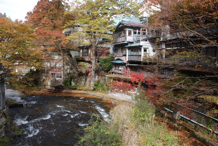
is a city in Fukushima Prefecture, Japan. , the city had an estimated population of 118,159 in 50,365 households, and a population density of 310 persons per km2. The total area of the city was . Geography Aizuwakamatsu is located in the western part of Fukushima Prefecture, in the southeast part of Aizu basin. Mountains * Mount Ōtodake (1416 m) * Mount Seaburi * Mount Oda * Mount Iimori Rivers * Aga River * Nippashi River * Yugawa River * Sesenagi River Lakes * Lake Inawashiro * Lake Wakasato * Lake Higashiyama * Lake Sohara Hot springs * Higashiyama Onsen * Ashinomaki Onsen Administrative divisions There are 11 administrative divisions (hamlets or ) in the city. * Wakamatsu * Machikita * Kouya * Kouzashi * Monden * Ikki * Higashiyama * Ōto * Minato * Kitaaizu * Kawahigashi Neighboring municipalities Fukushima Prefecture *North: Kitakata, Aizubange, Yugawa, Bandai *East: Koriyama, Inawashiro *West: Aizumisato *South: Shimogo, Tenei Climate Aizuwakamatsu h ... [...More Info...] [...Related Items...] OR: [Wikipedia] [Google] [Baidu] |
Cities Of Japan
A is a local administrative unit in Japan. Cities are ranked on the same level as and , with the difference that they are not a component of . Like other contemporary administrative units, they are defined by the Local Autonomy Law of 1947. City status Article 8 of the Local Autonomy Law sets the following conditions for a municipality to be designated as a city: *Population must generally be 50,000 or greater (原則として人口5万人以上) *At least 60% of households must be established in a central urban area (中心市街地の戸数が全戸数の6割以上) *At least 60% of households must be employed in commerce, industry or other urban occupations (商工業等の都市的業態に従事する世帯人口が全人口の6割以上) *Any other conditions set by prefectural ordinance must be satisfied (他に当該都道府県の条例で定める要件を満たしていること) The designation is approved by the prefectural governor and the Minister for Internal ... [...More Info...] [...Related Items...] OR: [Wikipedia] [Google] [Baidu] |
Iimori Hill
is a mountain near the city of Aizuwakamatsu, Fukushima Prefecture, Japan. It is notable as the site where members of the Byakkotai (White Tiger Corps) committed ritual suicide in 1868, during the Boshin War. It is located about 1.5 kilometers northeast of Tsuruga Castle. There are two monuments at the top of the mountain: one was a gift from the Italian Fascist Party in 1928, and the other was from Nazi Germany. They were installed to show reverence for the Byakkotai spirit. After the surrender of Japan at the end of World War II, members of the Occupation, specifically of the U.S. Army, replaced the Hakenkreuz on the German monument with an iron cross. Iimori Mountain has been heavily commercialized and the site includes many souvenir shops and exhibitions. The staircases from the foot of the mountain to the top are fairly steep, though there is an escalator. Downhill from Iimori Mountain stands , an octagonal wooden pagoda built in the 18th century, which formerly seale ... [...More Info...] [...Related Items...] OR: [Wikipedia] [Google] [Baidu] |
Yugawa, Fukushima
Nippashi River at Yugawa is a village located in Fukushima Prefecture, Japan. , the village had an estimated population of 3,051 in 924 households, and a population density of 190 persons per km2. The total area of the village was .. Geography Yugawa is located in the northern portion of the Aizu region of Fukushima Prefecture, in center of the Aizu Basin. *Rivers : Nippashi River, Agakawa River Neighboring municipalities Fukushima Prefecture *Aizuwakamatsu * Kitakata *Aizubange Demographics Per Japanese census data, the population of Yugawa has declined steadily over the past 70 years. Climate Yugawa has a Humid continental climate (Köppen ''Dfb'') characterized by warm summers and cold winters with heavy snowfall. The average annual temperature in Yugawa is 11.9 °C. The average annual rainfall is 1383 mm with September as the wettest month. The temperatures are highest on average in August, at around 25.6 °C, and lowest in January, at around -0.8 °C ... [...More Info...] [...Related Items...] OR: [Wikipedia] [Google] [Baidu] |
Aizubange, Fukushima
Eryū-ji temple in Aizubange is a town located in Fukushima Prefecture, Japan. , the town had an estimated population of 15,159 in 5487 households, and a population density of 170 persons per km2. The total area of the town was . Geography Aizubange is located in the northern portion of the Aizu region of Fukushima Prefecture in the western part of Aizu Basin. The basin extends from the center of the town to the east and is relatively flat, with many paddy fields. On the other hand, the western part of the town has many forests. The Aga River flows from the east to the north of the town, and the Tadami River flows to the west. *Mountains : Mount Takadera *Rivers : Tadami River, Agakawa Neighboring municipalities Fukushima Prefecture *Aizuwakamatsu * Kitakata * Yanaizu * Yugawa *Aizumisato * Nishiaizu Climate Aizubange has a Humid continental climate (Köppen ''Dfb'') characterized by warm summers and cold winters with heavy snowfall. The average annual temperature in Aizubang ... [...More Info...] [...Related Items...] OR: [Wikipedia] [Google] [Baidu] |
Kitakata, Fukushima
is a Cities of Japan, city located in Fukushima Prefecture, Japan. , the city had an estimated population of 46,269 in 16,769 households, and a population density of 83 persons per km2. The total area of the city was . Kitakata was once written '北方', which meant 'northern place'. Geography Kitakata is located at the far northern Aizu region of Fukushima Prefecture, bordered by Yamagata Prefecture to the north and Niigata Prefecture to the west. *Mountains: Mount Bandai, Mount Iide *Rivers: Aga River, Tadami River Neighboring municipalities Fukushima Prefecture *Aizuwakamatsu, Fukushima, Aizuwakamatsu *Nishiaizu, Fukushima, Nishiaizu *Kitashiobara, Fukushima, Kitashiobara *Bandai, Fukushima, Bandai *Aizubange, Fukushima, Aizubange *Yugawa, Fukushima, Yugawa Yamagata Prefecture *Yonezawa, Yamagata, Yonezawa *Iide, Yamagata, Iide *Oguni, Yamagata, Oguni Niigata Prefecture *Shibata, Niigata, Shibata *Aga, Niigata, Aga Climate Kitakata has a Humid continental climate (Köppen ''D ... [...More Info...] [...Related Items...] OR: [Wikipedia] [Google] [Baidu] |
Higashiyama Onsen
Higashiyama may refer to multiple things associated with Japan, including: * Higashiyama (surname), a Japanese surname * Higashiyama, Iwate, a former town in Iwata Prefecture * Higashiyama-ku, Kyoto, a ward of the city of Kyoto * Higashiyama culture, an aesthetic and architectural school from the Muromachi period * Emperor Higashiyama was the 113th emperor of Japan, according to the traditional order of succession.Imperial Household Agency (''Kunaichō'') 東山天皇 (113)/ref> Higashiyama's reign spanned the years from 1687 through to his abdication in 1709 corresponding to ... (1675–1710), Emperor of Japan from 1687 to 1709 See also * Higashiyama Station (other) * {{disambiguation ... [...More Info...] [...Related Items...] OR: [Wikipedia] [Google] [Baidu] |
Lake Sohara
A lake is an area filled with water, localized in a basin, surrounded by land, and distinct from any river or other outlet that serves to feed or drain the lake. Lakes lie on land and are not part of the ocean, although, like the much larger oceans, they do form part of the Earth's water cycle. Lakes are distinct from lagoons, which are generally coastal parts of the ocean. Lakes are typically larger and deeper than ponds, which also lie on land, though there are no official or scientific definitions. Lakes can be contrasted with rivers or streams, which usually flow in a channel on land. Most lakes are fed and drained by rivers and streams. Natural lakes are generally found in mountainous areas, rift zones, and areas with ongoing glaciation. Other lakes are found in endorheic basins or along the courses of mature rivers, where a river channel has widened into a basin. Some parts of the world have many lakes formed by the chaotic drainage patterns left over from the last ic ... [...More Info...] [...Related Items...] OR: [Wikipedia] [Google] [Baidu] |
Lake Higashiyama
A lake is an area filled with water, localized in a basin, surrounded by land, and distinct from any river or other outlet that serves to feed or drain the lake. Lakes lie on land and are not part of the ocean, although, like the much larger oceans, they do form part of the Earth's water cycle. Lakes are distinct from lagoons, which are generally coastal parts of the ocean. Lakes are typically larger and deeper than ponds, which also lie on land, though there are no official or scientific definitions. Lakes can be contrasted with rivers or streams, which usually flow in a channel on land. Most lakes are fed and drained by rivers and streams. Natural lakes are generally found in mountainous areas, rift zones, and areas with ongoing glaciation. Other lakes are found in endorheic basins or along the courses of mature rivers, where a river channel has widened into a basin. Some parts of the world have many lakes formed by the chaotic drainage patterns left over from the last ic ... [...More Info...] [...Related Items...] OR: [Wikipedia] [Google] [Baidu] |
Lake Wakasato
A lake is an area filled with water, localized in a basin, surrounded by land, and distinct from any river or other outlet that serves to feed or drain the lake. Lakes lie on land and are not part of the ocean, although, like the much larger oceans, they do form part of the Earth's water cycle. Lakes are distinct from lagoons, which are generally coastal parts of the ocean. Lakes are typically larger and deeper than ponds, which also lie on land, though there are no official or scientific definitions. Lakes can be contrasted with rivers or streams, which usually flow in a channel on land. Most lakes are fed and drained by rivers and streams. Natural lakes are generally found in mountainous areas, rift zones, and areas with ongoing glaciation. Other lakes are found in endorheic basins or along the courses of mature rivers, where a river channel has widened into a basin. Some parts of the world have many lakes formed by the chaotic drainage patterns left over from the last ic ... [...More Info...] [...Related Items...] OR: [Wikipedia] [Google] [Baidu] |
Lake Inawashiro
is the fourth-largest lake in Japan, located in central Fukushima Prefecture, south of Mount Bandai. It is also known as the . The lake is located within the borders of Bandai-Asahi National Park. It is a surface area of , circumference of , depth of and is located at an altitude of . In winter swans migrate to the beaches of the lake and stay there until spring. History Lake Inawashiro was formed some 30–40,000 years ago when a tectonic depression was dammed by a major eruption and pyroclastic flow from Mount Bandai. The water is acidic with a pH value of approximately 5.0, and has a high degree of transparency. The water level was considerably less during the Jōmon period as numerous artifacts and ceramic fragments have been found offshore. The lake water is an important source for irrigation in the Aizu region of western Fukushima Prefecture. An irrigation canal was completed during the Edo period and another, the Asaka Canal, in 1882. A third canal completed in 1915 su ... [...More Info...] [...Related Items...] OR: [Wikipedia] [Google] [Baidu] |


_2020.jpg)