|
AH62
Asian Highway 62 (AH62) is an international route running from Petropavlovsk in Kazakhstan to Mazar-i-Sharif in Afghanistan. This international highway transits Uzbekistan also. Route Petropavlovsk – Arkalyk – Zhezkazgan – Kyzylorda – Shymkent – Zhibek Zholy – Chernyavka – Tashkent – Syrdaria – Samarkand – Guzar – Termez – Hairatan – Mazar-i-Sharif. Associated routes Kazakhstan * : Petropavlovsk - Zhezkazgan. * : Zhezkazgan - Kyzylorda * Kyzylorda – Shymkent – Zhibek Zholy Uzbekistan * Chernyavka – Tashkent – Syrdaria – Samarkand * : Samarkand – Guzar – Termez. * : Termez - Khairaton (Border of Afghanistan) Afghanistan * Hairatan Highway : Hairatan - Mazar-i-Sharif : . See also * AH60, Asian Highway 60 * Asian Highway Network#Route log, List of Asian Highways References External links Treaty on Asian Highways with routes {{DEFAULTSORT:AH60 Asian Highway Network Roads in Afghanistan Roads in Kazakhstan Roads in Uzbekistan ... [...More Info...] [...Related Items...] OR: [Wikipedia] [Google] [Baidu] |
Asian Highway Network
The Asian Highway Network (AH), also known as the Great Asian Highway, is a cooperative project among countries in Asia and the United Nations Economic and Social Commission for Asia and the Pacific (ESCAP) to improve their connectivity via highway systems. It is one of the three pillars of the Asian Land Transport Infrastructure Development (ALTID) project, endorsed by the ESCAP commission at its 48th session in 1992, comprising Asian Highway, Trans-Asian Railway (TAR) and facilitation of land transport projects. Agreements have been signed by 32 countries to allow the highway to cross the continent and also reach to Europe. Some of the countries taking part in the highway project are India ( Look-East connectivity projects), Sri Lanka, Pakistan, China, Iran, Japan, South Korea, Nepal and Bangladesh. Most of the funding comes from the larger, more advanced Asian nations such as China, South Korea and Singapore as well as international agencies such as the Asian Development Ban ... [...More Info...] [...Related Items...] OR: [Wikipedia] [Google] [Baidu] |
Afghanistan–Uzbekistan Friendship Bridge
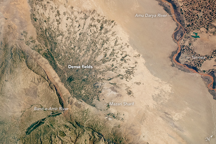
The Afghanistan–Uzbekistan Friendship Bridge is a road and rail bridge across the river Amu Darya, connecting the town of Hairatan in the northern Balkh province of Afghanistan with Termez in the Surxondaryo Region of Uzbekistan. The bridge was built by the Soviet Union and opened in 1982 to supply its forces who were based in Afghanistan at the time. It is used today for trade and travel purposes between the two countries. Overview It is the only fixed link across the Afghanistan–Uzbekistan border, located some north of the city of Mazar-i-Sharif. The nearest other bridge across the Amu Darya is some to the west, a pipeline bridge crossing the Afghanistan-Turkmenistan border from/to the Lebap Region. Before the Soviet–Afghan War there was no fixed road or rail link between Afghanistan and Uzbekistan, which at the time was part of the Soviet Union. In 1982, several years after falling under Soviet occupation in Operation Storm-333, Afghanistan agreed to allow the Sovie ... [...More Info...] [...Related Items...] OR: [Wikipedia] [Google] [Baidu] |
Amu Darya
The Amu Darya, tk, Amyderýa/ uz, Amudaryo// tg, Амударё, Amudaryo ps, , tr, Ceyhun / Amu Derya grc, Ὦξος, Ôxos (also called the Amu, Amo River and historically known by its Latin language, Latin name or Greek ) is a major river in Central Asia and Afghanistan. Rising in the Pamir Mountains, north of the Hindu Kush, the Amu Darya is formed by the confluence of the Vakhsh River, Vakhsh and Panj River, Panj rivers, in the Tigrovaya Balka Nature Reserve on the border between Afghanistan and Tajikistan, and flows from there north-westwards into the South Aral Sea, southern remnants of the Aral Sea. In its upper course, the river forms part of Afghanistan's northern border with Tajikistan, Uzbekistan, and Turkmenistan. In ancient history, the river was regarded as the boundary of Greater Iran with "Turan", which roughly corresponded to present-day Central Asia.B. SpulerĀmū Daryā in Encyclopædia Iranica, online ed., 2009 The Amu Darya has a flow of about 70 cubic k ... [...More Info...] [...Related Items...] OR: [Wikipedia] [Google] [Baidu] |
Petropavl
Petropavl ( kk, Петропавл, Petropavl ) or Petropavlovsk () is a city on the Ishim River in northern Kazakhstan close to the border with Russia. It is the capital of the North Kazakhstan Region. Population: 218,956. The city is also known colloquially in Kazakh as Kyzylzhar ( kk, Қызылжар, Qyzyljar, "Red Cliff"). Petropavl is about from Kokshetau, northwest of the national capital Astana along the A1, from Omsk. Physical-geographical characteristics Geographical location Petropavl is located in the southwestern part of the West Siberian Plain, on the right bank of the Ishim river, the longest tributary of the Irtysh river. Not far from Petropavl there are many lakes and ponds, for example: Lake Bolshoe Beloe, Lake Pestroye, Lake Kishtibish, Lake Maloe Beloe and Bitter lake. Also, within the city can be found small forests, mostly consisting of birches and pine plantations. Climate The climate is a dry version of the humid continental (Köppen ''Dfb'') typ ... [...More Info...] [...Related Items...] OR: [Wikipedia] [Google] [Baidu] |
Mazar-i-Sharif
, official_name = , settlement_type = City , image_skyline = , pushpin_map = Afghanistan#Bactria#West Asia , pushpin_label = Mazar-i-Sharif , pushpin_label_position = bottom , pushpin_mapsize = , pushpin_relief = yes , pushpin_map_caption = Location in Afghanistan , coordinates = , subdivision_type = Country , subdivision_name = Afghanistan , subdivision_type1 = Province , subdivision_type2 = District , subdivision_name1 = Balkh Province , subdivision_name2 = Mazar-i-Sharif District , established_title = , established_date = , leader_title = Mayor , leader_name = Abdullhaq Khurami , area_total_km2 = , area_land_km2 ... [...More Info...] [...Related Items...] OR: [Wikipedia] [Google] [Baidu] |
Economic And Social Commission For Asia And The Pacific
The United Nations Economic and Social Commission for Asia and the Pacific (ESCAP) is one of the five regional commissions under the jurisdiction of the United Nations Economic and Social Council. It was established in order to increase economic activity in Asia and the Far East, as well as to foster economic relations between the region and other areas of the world. The commission is composed of 53 Member States and nine Associate members, mostly from the Asia and Pacific regions. In addition to countries in Asia and the Pacific, the commission's members includes France, the Netherlands, the United Kingdom and the United States. The region covered by the commission is home to 4.1 billion people, or two-thirds of the world's population, making ESCAP the most comprehensive of the United Nations' five regional commissions. History The commission was first established by the Economic and Social Council on 28 March 1947 as the United Nations Economic Commission for Asia and the ... [...More Info...] [...Related Items...] OR: [Wikipedia] [Google] [Baidu] |
UNESCAP
The United Nations Economic and Social Commission for Asia and the Pacific (ESCAP) is one of the five regional commissions under the jurisdiction of the United Nations Economic and Social Council. It was established in order to increase economic activity in Asia and the Far East, as well as to foster economic relations between the region and other areas of the world. The commission is composed of 53 Member States and nine Associate members, mostly from the Asia and Pacific regions. In addition to countries in Asia and the Pacific, the commission's members includes France, the Netherlands, the United Kingdom and the United States. The region covered by the commission is home to 4.1 billion people, or two-thirds of the world's population, making ESCAP the most comprehensive of the United Nations' five regional commissions. History The commission was first established by the Economic and Social Council on 28 March 1947 as the United Nations Economic Commission for Asia and the F ... [...More Info...] [...Related Items...] OR: [Wikipedia] [Google] [Baidu] |
Hairatan
Hairatan ( prs, حیرتان; ps, حیراتان; Uzbek Cyrillic: Ҳайратон, Uzbek Latin: Hayraton) is a border town in northern Balkh Province of Afghanistan. The Hairatan dry port and border checkpoint is located in the eastern section of the town. It sits along the Amu Darya river in the Kaldar District of Balkh province. The river forms the border with neighboring Uzbekistan, and the two nations are connected by the Afghanistan–Uzbekistan Friendship Bridge. The city of Termez in Uzbekistan is a short distance away to the northwest of Hairatan, on the other side of the Amu Darya river. Situated at an altitude of approximately , Hairatan is one of the major transporting, shipping and receiving locations in Afghanistan. It is also an official border crossing between the people of Afghanistan and Uzbekistan. Security in and around town is provided by the Afghan National Security Forces, which includes the Afghan Border Force. Every visitor or traveler between Afghanista ... [...More Info...] [...Related Items...] OR: [Wikipedia] [Google] [Baidu] |
AH60
Asian Highway 60 (AH60) is an international route running from Omsk, Omsk Oblast, in Russia to Burubaytal, Jambyl Region, in Kazakhstan. About of route is located in Russia and is located in Kazakhstan. Route Omsk - Cherlak - (Russia–Kazakhstan border) – Pnirtyshskoe – Pavlodar – Semipalatinsk – Georgievka – Taskesken – Ucharal – Almaty – Kaskelen – Burubaytal Associated routes Russia *: Omsk Omsk (; rus, Омск, p=omsk) is the administrative center and largest city of Omsk Oblast, Russia. It is situated in southwestern Siberia, and has a population of over 1.1 million. Omsk is the third largest city in Siberia after Novosibirsk ... – Cherlak – border with Kazakhstan . This section of route AH60 runs concurrently with European route E127. Kazakhstan *: Pnirtyshskoe - Georgievka :. *: Georgievka - Almaty : *: Junctions ;Russia : Omsk ;Kazakhstan : Pavlodar : Taskesken : Ucharal : Almaty : Burubaital See also * Asian Highway 6 * ... [...More Info...] [...Related Items...] OR: [Wikipedia] [Google] [Baidu] |
Roads In Afghanistan
Transport in Afghanistan is done mostly by road, rail and air. Much of the nation's road network was built in the mid-20th century but left to ruin during the last two decades of that century due to war and political turmoil. Officials of the current Islamic Emirate have continued to improve the national highways, roads, and bridges. In 2008, there were about 700,000 vehicles registered in Kabul. At least 1,314 traffic collisions were reported in 2022. Landlocked Afghanistan has no seaports, but the Amu River, which forms part of the nation's border with Turkmenistan, Uzbekistan and Tajikistan, does have substantial traffic. Rebuilding and expanding its airports, roads, rail network, and land ports has led to rapid economic growth in recent years. There are 46 airports in Afghanistan as of 2021. Road Most major highways were asphalted around the mid-20th century with assistance from the United States and the Soviet Union. The Soviets built a highway and tunnel through the Sa ... [...More Info...] [...Related Items...] OR: [Wikipedia] [Google] [Baidu] |
Roads In Kazakhstan
A road is a linear way for the conveyance of traffic that mostly has an road surface, improved surface for use by vehicles (motorized and non-motorized) and pedestrians. Unlike streets, the main function of roads is transportation. There are road hierarchy, many types of roads, including parkways, avenue (landscape), avenues, controlled-access highways (freeways, motorways, and expressways), tollways, interstates, highways, thoroughfares, and local roads. The primary features of roads include lanes, sidewalks (pavement), roadways (carriageways), median strip, medians, shoulder (road), shoulders, road verge, verges, bike paths (cycle paths), and shared-use paths. Definitions Historically many roads were simply recognizable routes without any formal construction or some maintenance. The Organisation for Economic Co-operation and Development, Organization for Economic Co-operation and Development (OECD) defines a road as "a line of communication (travelled way) using a stabiliz ... [...More Info...] [...Related Items...] OR: [Wikipedia] [Google] [Baidu] |


