|
A468 Road
The A468 is a principal road from Newport to Nantgarw. The current route begins at the A467 in Bassaleg then passes through Rhiwderin, Machen, Trethomas, Bedwas and Caerphilly, terminating on the A470. History Originally the A468 began at the Handpost Pub on the junction with the former A467 (reclassified to B4240) and proceeded west along Bassaleg Road, passing under a pair of stone arch bridges carrying the Ebbw Valley Railway and the Brecon and Merthyr Railway The Brecon and Merthyr Tydfil Junction Railway (B&MR) was a railway company in Wales. It was originally intended to link the towns in its name. Finding its access to Merthyr difficult at first, it acquired the Rumney Railway, an old plateway, and ... before reaching the current starting point. References Roads in Caerphilly County Borough Roads in Newport, Wales Roads in Rhondda Cynon Taf {{Wales-road-stub ... [...More Info...] [...Related Items...] OR: [Wikipedia] [Google] [Baidu] |
Bassaleg
Bassaleg ( cy, Basaleg) is a suburb on the west side of Newport, Wales. It is in the Graig electoral ward and community.Bassaleg is located two miles northwest of Newport city centre. Bassaleg is bounded by the A467 road (A4072) to the east, the railway spur to Lower Machen (the former Brecon and Merthyr Railway) to the north, the St Mellons Road (B4288) to the south and Rhiwderin to the east. The Ebbw River runs through the area. The A468 road passes through towards Caerphilly and junction 28 of the M4 motorway is less than a mile to the south. St Basil's Church The parish church of St. Basil's is a Grade II* listed building. It has been suggested that site of the church was originally dedicated to Saint Gwladys. Historians have suggested that Bassaleg is the only British place whose name derives from the word ''basilica'', a term used in early Christianity for a church containing the body of a saint. Until the mid-19th century, a grave chapel for St. Gwladys surviv ... [...More Info...] [...Related Items...] OR: [Wikipedia] [Google] [Baidu] |
Nantgarw
Nantgarw is a village in the county borough of Rhondda Cynon Taf, Wales, near Cardiff. From an electoral and administrative perspective Nantgarw falls within the ward of Taffs Well, a village some south, but historically fell within the boundaries of Caerphilly, which is a major town located less than to the east. The original village was almost entirely destroyed by the development of the A470 trunk road, which was situated at the location of the current A468 junction. Located close to the A470, Nantgarw is within easy reach of the town of Pontypridd ( to the northwest) and Cardiff City centre (around further south). Nantgarw is the home of the Nantgarw tradition of folk dancing. History Nantgarw lies on the River Taff. It is known for its porcelain, produced in between 1813-1814, and later between 1817-1820 at the Nantgarw Pottery, commemorated at the Nantgarw Chinaworks Museum. The potter and painter William Billingsley is credited with starting the porcelain trade he ... [...More Info...] [...Related Items...] OR: [Wikipedia] [Google] [Baidu] |
Newport, Wales
Newport ( cy, Casnewydd; ) is a city and county borough in Wales, situated on the River Usk close to its confluence with the Severn Estuary, northeast of Cardiff. With a population of 145,700 at the 2011 census, Newport is the third-largest authority with city status in Wales, and seventh most populous overall. Newport became a unitary authority in 1996 and forms part of the Cardiff-Newport metropolitan area. Newport was the site of the last large-scale armed insurrection in Great Britain, the Newport Rising of 1839. Newport has been a port since medieval times when the first Newport Castle was built by the Normans. The town outgrew the earlier Roman town of Caerleon, immediately upstream and now part of the borough. Newport gained its first charter in 1314. It grew significantly in the 19th century when its port became the focus of coal exports from the eastern South Wales Valleys. Newport was the largest coal exporter in Wales until the rise of Cardiff in the mid ... [...More Info...] [...Related Items...] OR: [Wikipedia] [Google] [Baidu] |
A467 Road
List of A roads in zone 4 in Great Britain Great Britain is an island in the North Atlantic Ocean off the northwest coast of continental Europe. With an area of , it is the largest of the British Isles, the largest European island and the ninth-largest island in the world. It is ... starting north of the A4 and south/west of the A5 (roads beginning with 4). __TOC__ Single- and double-digit roads Triple-digit roads Only roads that have individual articles have been linked in the "Road" column below. Four-digit roads (40xx) Four-digit roads (41xx) Four-digit roads (42xx and higher) References {{UK road lists 4 4 ... [...More Info...] [...Related Items...] OR: [Wikipedia] [Google] [Baidu] |
Rhiwderin
Rhiwderin ( cy, Rhiwderyn) is a small village in the west of the city of Newport, South Wales. It lies in the community parish and electoral district (ward) of Graig. The original village lies across a level crossing alongside the Ebbw Valley Railway and off the main A468 Newport—Caerphilly road. There are additional houses on the other side of the main road known as Rhiwderin Heights which have almost merged the village with neighbouring Bassaleg. The Pentrepoeth School is the local primary school in the area. Rhiwderin Community Centre is located in the former village school and administered by Graig Community Council. The village was served by Rhiwderin railway station until 1954. Rhyderin lies on the route of the old Brecon and Merthyr Tydfil Junction Railway line. The line now ends at Machen Quarry and carries only freight trains. The trackbed from Machen to Caerphilly is now part of National Cycle Route 4 Between these, the route runs through Reading, Bath, ... [...More Info...] [...Related Items...] OR: [Wikipedia] [Google] [Baidu] |
Machen
Machen (from Welsh ' "place (of)" + ', a personal name) is a large village three miles east of Caerphilly, south Wales. It is situated in the Caerphilly borough within the historic boundaries of Monmouthshire. It neighbours Bedwas and Trethomas, and forms a council ward in conjunction with those communities. It lies on the Rhymney River. Mynydd Machen (Machen Mountain) provides a view over the village. It is possible to walk up to and along the top of the mountain, where a number of large boulders are present. Machen has a successful boules (petanque) team that are located at the rugby club. The team has had a team in the first Division of the boules in Gwent (BIG) league for the last 4 years. Industrial history Machen was a village rooted in the iron and coal industries stretching from the 17th Century. Though little trace remains, the village was the site of the Machen Forge and several coal mines. A local history trail visits some of these sites. Machen Forge was an earl ... [...More Info...] [...Related Items...] OR: [Wikipedia] [Google] [Baidu] |
Trethomas
Trethomas ( en, Thomastown) is a small village northeast of Caerphilly, southeast Wales, situated in the Caerphilly county borough, within the historic boundaries of Monmouthshire. It neighbours Bedwas and Machen, and forms a council ward in conjunction with those communities. Post 1900 New Town With an original name of Thomastown, it was mainly built by William James Thomas, a co-owner of the Bedwas Navigation Colliery Company, (also of mines in Aberdare in the Cynon Valley). Most of the earlier parts of Trethomas were built in and around 1900 - 1913, when the mine was developing and at the apex of coal production in the South Wales coalfield. The terraced streets of Trethomas were appropriately named, some were named after members of William Thomas's family, hence the names: William, James, Thomas, and Mary. Others involved association with local areas, such as Navigation Street (associated with the Bedwas Navigation Colliery Company), Coronation Street (for Queen Elizabeth ... [...More Info...] [...Related Items...] OR: [Wikipedia] [Google] [Baidu] |
Bedwas
Bedwas is a town situated two miles north-east of Caerphilly, south Wales, situated in the Caerphilly county borough, within the historic boundaries of Monmouthshire. Bedwas neighbours Trethomas, Graig-y-Rhacca and Machen, and forms a council ward in conjunction with those communities. Etymology The name Bedwas means "grove, bank or place of birch trees", which is found in more modern Welsh as '. Early history Traditionally a farming community, Bedwas was originally called Lower Bedwas. Maesycwmmer, a small village not far from Bedwas, was called Upper Bedwas. The two villages became known as what we know them today in the 19th century. Bedwas owes much of its own development to the development of the South Wales coalfield and the Welsh coal mining industry. This is depicted in the early Census records. According to the 1811 census, Lower Bedwas consisted of 47 occupied houses and 65 families. 59 of these families were engaged in agriculture and 6 in trade, manufacture ... [...More Info...] [...Related Items...] OR: [Wikipedia] [Google] [Baidu] |
Caerphilly
Caerphilly (, ; cy, Caerffili, ) is a town and community in Wales. It is situated at the southern end of the Rhymney Valley. It is north of Cardiff and northwest of Newport. It is the largest town in Caerphilly County Borough, and lies within the historic borders of Glamorgan, on the border with Monmouthshire. At the 2011 Census, the town had a population of 41,402 while the wider Caerphilly Local Authority area has a population of 178,806. Toponym The name of the town in Welsh, , means "the fort () of Ffili". Despite lack of evidence, tradition states that a monastery was built by St Cenydd, a sixth-century Christian hermit from the Gower Peninsula, in the area. The Welsh cantref in the medieval period was known as Senghenydd. It is said that St Cenydd's son, St Ffili, built a fort in the area thus giving the town its name. Another explanation given for the toponym is that the town was named after the Anglo-Norman Marcher Lord, Philip de Braose. History The tow ... [...More Info...] [...Related Items...] OR: [Wikipedia] [Google] [Baidu] |
A470 Road
The A470 (also named the Cardiff to Glan Conwy Trunk Road) is a trunk road in Wales. It is the country's longest road at and links the capital Cardiff on the south coast to Llandudno on the north coast. While previously one had to navigate the narrow roads of Llanidloes and Dolgellau, both these market towns are now bypassed due to extensive road modernisation. The from Cardiff Bay to Merthyr Tydfil are mainly dual carriageway, but most of the route from north of Merthyr to Llandudno is single carriageway. Route National parks The road travels through two of the national parks of Wales: the Brecon Beacons, and Snowdonia National Park starting just south of Dinas Mawddwy. Cardiff Bay – Merthyr Tydfil The southernmost point of the route is in Cardiff Bay, outside the Wales Millennium Centre. It runs up Lloyd George Avenue (this was previously Collingdon Road, and the A470 previously ran along the parallel Bute Street), and continues along St. Mary Street in central C ... [...More Info...] [...Related Items...] OR: [Wikipedia] [Google] [Baidu] |
Ebbw Valley Railway
The Ebbw Valley Railway ( cy, Rheilffordd Cwm Ebwy) is a branch line of the South Wales Main Line in South Wales. Transport for Wales Rail provides an hourly passenger service each way between Ebbw Vale Town and Cardiff Central, and an hourly service each way between Crosskeys and Newport. The line was opened by the Monmouthshire Railway and Canal Company and the Great Western Railway (GWR) operated a passenger service from the 1850s between Newport and Ebbw Vale. The line became part of British Railways Western Region in 1948, following the nationalisation of the railways. Passenger services were withdrawn in 1962. However, the route continued to be used to carry freight to and from the Corus steelworks in Ebbw Vale, until its closure in 2002. Proposals to re-open the existing freight railway line to passenger services were first mooted in 1998. The Welsh Assembly Government announced their commitment to the project in 2002, as part of a package of measures to help t ... [...More Info...] [...Related Items...] OR: [Wikipedia] [Google] [Baidu] |
Brecon And Merthyr Railway
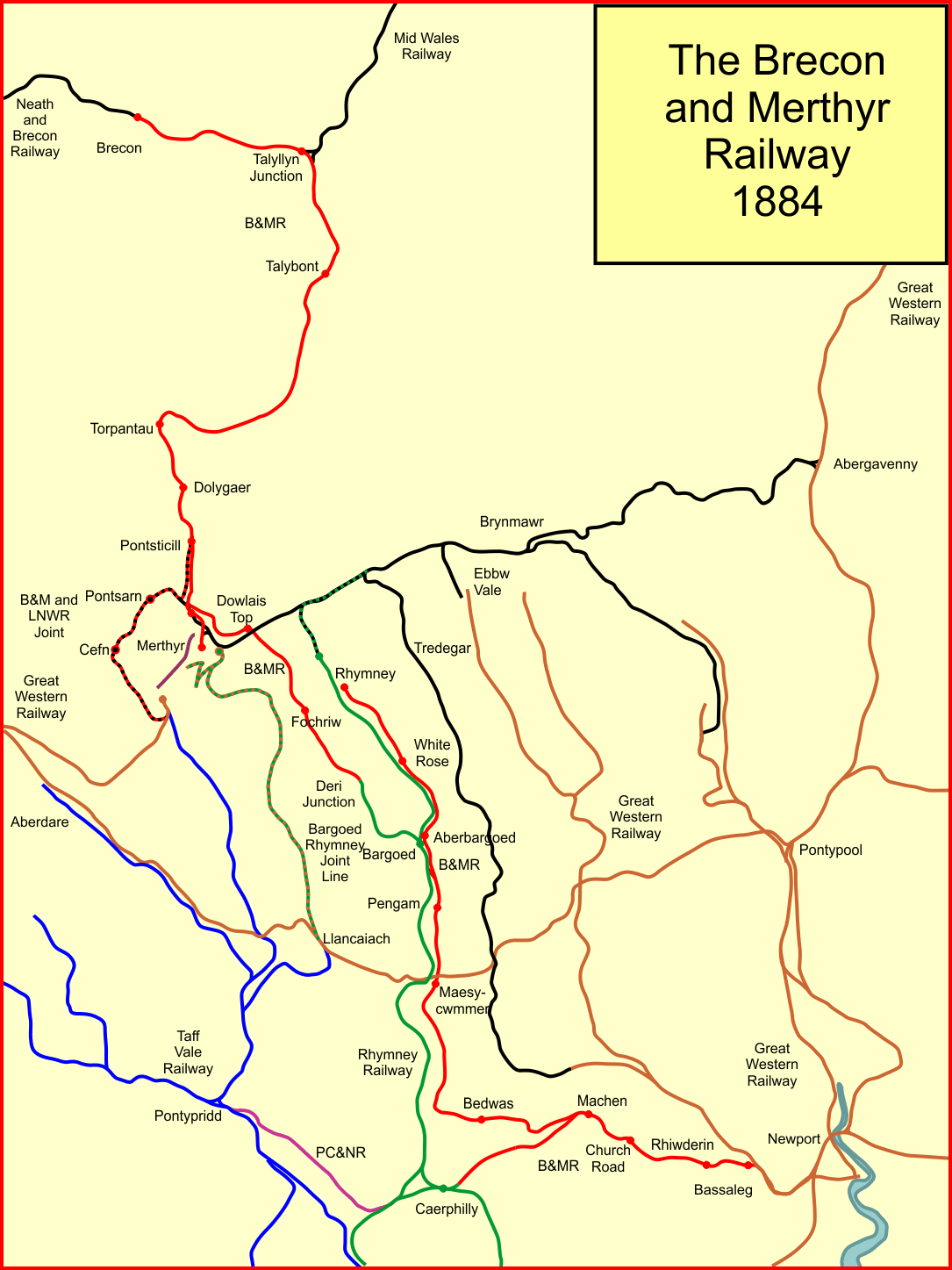
The Brecon and Merthyr Tydfil Junction Railway (B&MR) was a railway company in Wales. It was originally intended to link the towns in its name. Finding its access to Merthyr difficult at first, it acquired the Rumney Railway, an old plateway, and this gave it access to Newport docks. This changed its emphasis from rural line to mineral artery. It opened at the Brecon end to a point near Dowlais in 1863, and in 1865 it opened a disconnected section from Rhymney to Newport. In due course the company connected the two sections and reached Dowlais and Merthyr, but had to concede sharing a route with the powerful London and North Western Railway. The B&MR was always short of money, and was notable for its prodigious gradients, but it survived until the grouping of 1923, when it became part of the Great Western Railway. Its network declined steeply after 1945, and passenger operation ceased in 1962. Goods and mineral operation also lost its market, and as of 2020, only a short stub to ... [...More Info...] [...Related Items...] OR: [Wikipedia] [Google] [Baidu] |


