|
480 BC
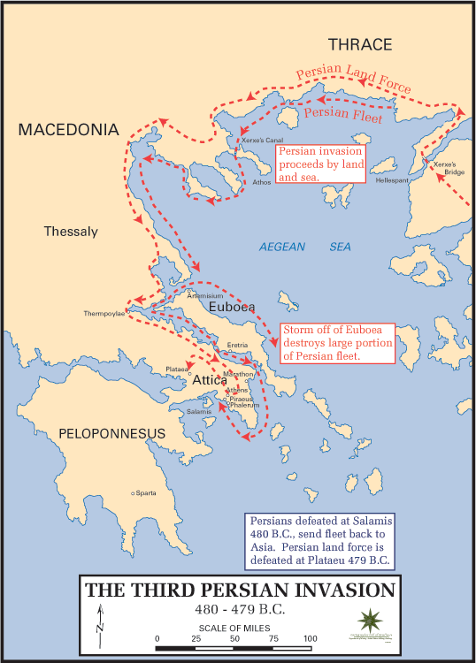
__NOTOC__ Year 480 BC was a year of the pre-Julian Roman calendar. At the time, it was known as the Year of the Consulship of Vibulanus and Cincinnatus (or, less frequently, year 274 ''Ab urbe condita''). The denomination 480 BC for this year has been used since the early medieval period, when the Anno Domini calendar era became the prevalent method in Europe for naming years. Events By place Greece * May – King Xerxes I of Persia marches from Sardis and onto Thrace and Macedonia. * The Greek congress decides to send a force of 10,000 Greeks, including hoplites and cavalry, to the Vale of Tempe, through which they believe the Persian army will pass. The force includes Lacedaemonians led by Euanetos and Athenians under Themistocles. Warned by Alexander I of Macedon that the vale can be bypassed elsewhere and that the army of Xerxes is overwhelming, the Greeks decide not to try to hold there and vacate the vale. * August 20 or September 8-10 – The Battle of T ... [...More Info...] [...Related Items...] OR: [Wikipedia] [Google] [Baidu] |
Persian Invasion
Persian invasion may refer to: * Persian invasion of Scythia, 513 BC * Greco-Persian Wars ** First Persian invasion of Greece, 492–490 BC ** Second Persian invasion of Greece The second Persian invasion of Greece (480–479 BC) occurred during the Greco-Persian Wars, as King Xerxes I of Persia sought to conquer all of Greece. The invasion was a direct, if delayed, response to the defeat of the first Persian invasion ..., 480–479 BC * Persian Invasion of Daghestan, 1741–1743 AD {{disambig ... [...More Info...] [...Related Items...] OR: [Wikipedia] [Google] [Baidu] |
Ancient Greece
Ancient Greece ( el, Ἑλλάς, Hellás) was a northeastern Mediterranean civilization, existing from the Greek Dark Ages of the 12th–9th centuries BC to the end of classical antiquity ( AD 600), that comprised a loose collection of culturally and linguistically related city-states and other territories. Most of these regions were officially unified only once, for 13 years, under Alexander the Great's empire from 336 to 323 BC (though this excludes a number of Greek city-states free from Alexander's jurisdiction in the western Mediterranean, around the Black Sea, Cyprus, and Cyrenaica). In Western history, the era of classical antiquity was immediately followed by the Early Middle Ages and the Byzantine period. Roughly three centuries after the Late Bronze Age collapse of Mycenaean Greece, Greek urban poleis began to form in the 8th century BC, ushering in the Archaic period and the colonization of the Mediterranean Basin. This was followed by the age of Classical G ... [...More Info...] [...Related Items...] OR: [Wikipedia] [Google] [Baidu] |
Crestonia
Crestonia (or Crestonice) ( el, Κρηστωνία) was an ancient region immediately north of Mygdonia. The Echeidorus river, which flowed through Mygdonia into the Thermaic Gulf, had its source in Crestonia. It was partly occupied by a remnant of the Pelasgi, who spoke a different language from their neighbors (Thracians and Paeonians); later the Greeks. The main towns of Crestonia were Creston (''Crestone'') and Gallicum (Romanized name). The region, along with Mygdonia, was held by Paeonians for a time, later by Thracians. At the time of the invasion of Xerxes I of Persia, Crestonia was ruled by an independent Thracian prince (Herodotus, 8. 116). By the time of the commencement of the Peloponnesian war, Crestonia had been annexed to the kingdom of Macedonia. Today, ancient Crestonia is comprehended within the regional units of Kilkis and Thessaloniki (northern part) in Greece Greece,, or , romanized: ', officially the Hellenic Republic, is a country in Southeast Eu ... [...More Info...] [...Related Items...] OR: [Wikipedia] [Google] [Baidu] |
Struma River
The Struma or Strymónas ( bg, Струма ; el, Στρυμόνας ; tr, (Struma) Karasu , 'black water') is a river in Bulgaria and Greece. Its ancient name was Strymṓn (Greek: Στρυμών ). Its drainage area is , of which in Bulgaria, in Greece and the remaining in North Macedonia and Serbia. It takes its source from the Vitosha Mountain in Bulgaria, runs first westward, then southward, forming a number of gorges, enters Greek territory at the Kula village. In Greece it is the main waterway feeding and exiting from Lake Kerkini, a significant centre for migratory wildfowl. The river flows into the Strymonian Gulf in Aegean Sea, near Amphipolis in the Serres regional unit. The river's length is (of which in Bulgaria, making it the country's fifth-longest and one of the longest rivers that run solely in the interior of the Balkans. Parts of the river valley belong to a Bulgarian (Pirin Macedonia) coal-producing area, more significant in the past than nowadays; the ... [...More Info...] [...Related Items...] OR: [Wikipedia] [Google] [Baidu] |
Pydna
Pydna (in Greek: Πύδνα, older transliteration: Pýdna) was a Greek city in ancient Macedon, the most important in Pieria. Modern Pydna is a small town and a former municipality in the northeastern part of Pieria regional unit, Greece. Since the 2011 local government reform it is part of the municipality Pydna-Kolindros, of which it is a municipal unit. The municipal unit has an area of 105.059 km2, the community 41.334 km2. Pydna is situated in fertile land close to the Thermaic Gulf coast. The main village of the former municipality is Kitros. It lies 6 km north of Korinos, 8 km south of Methoni and 13 km northeast of Katerini. Motorway 1 and the Piraeus–Platy railway (nearest station at Korinos) pass east of the village. Ancient Pydna Ancient Pydna was already a part of the Macedonian kingdom under Alexander I (Thucydides I.137.1). It was unsuccessfully besieged by the Athenians in 432 BC and again, after seceding from the Macedonian kingdom, ... [...More Info...] [...Related Items...] OR: [Wikipedia] [Google] [Baidu] |
Colony
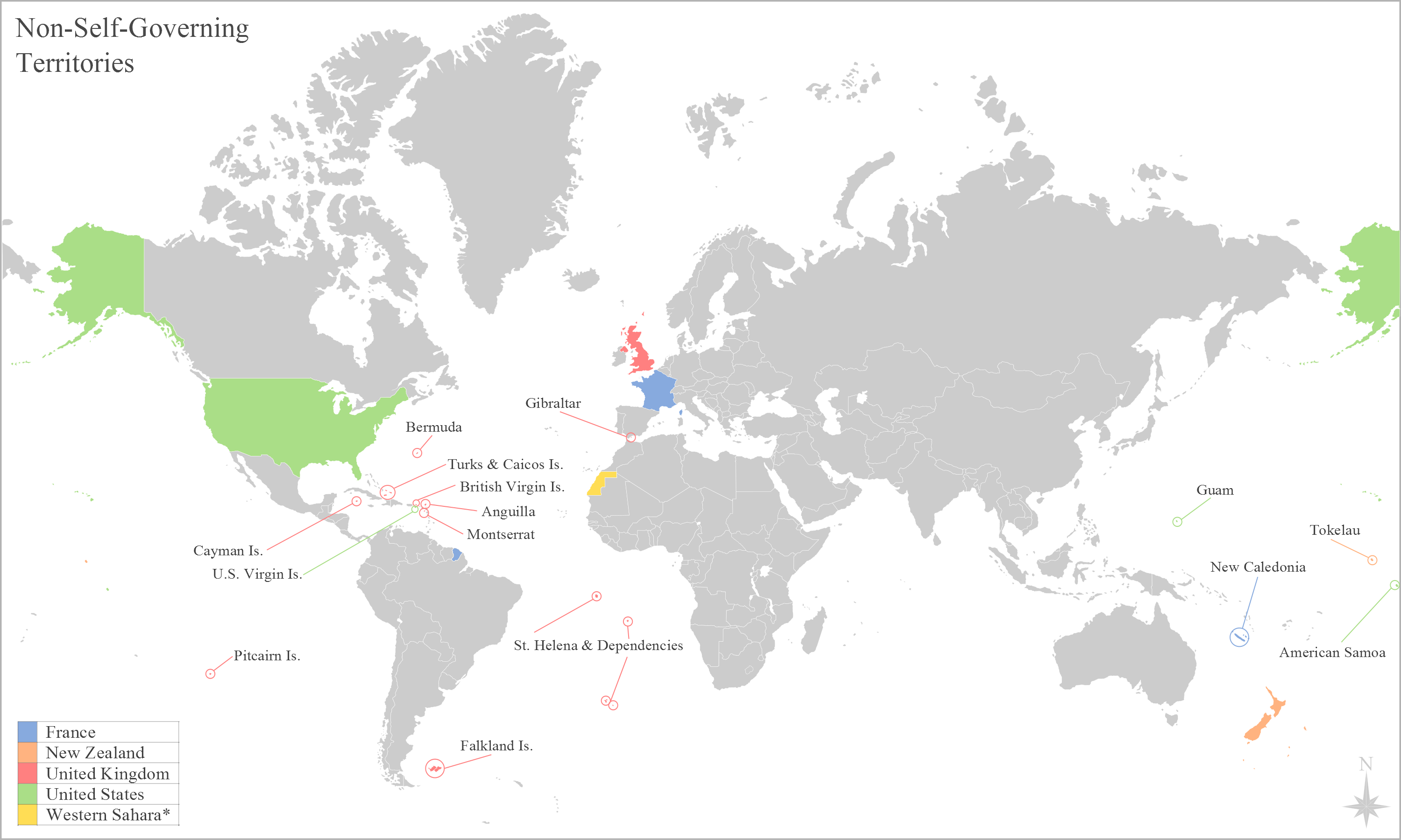
In modern parlance, a colony is a territory subject to a form of foreign rule. Though dominated by the foreign colonizers, colonies remain separate from the administration of the original country of the colonizers, the ''metropole, metropolitan state'' (or "mother country"). This administrative colonial separation makes colonies neither incorporated territories nor client states. Some colonies have been organized either as dependent territory, dependent territories that are Chapter XI of the United Nations Charter, not sufficiently self-governed, or as self-governing colony, self-governed colonies controlled by settler colonialism, colonial settlers. The term colony originates from the ancient rome, ancient Roman ''colonia (Roman), colonia'', a type of Roman settlement. Derived from ''colon-us'' (farmer, cultivator, planter, or settler), it carries with it the sense of 'farm' and 'landed estate'. Furthermore the term was used to refer to the older Greek ''apoikia'' (), which w ... [...More Info...] [...Related Items...] OR: [Wikipedia] [Google] [Baidu] |
Boeotia
Boeotia ( ), sometimes Latinized as Boiotia or Beotia ( el, Βοιωτία; modern: ; ancient: ), formerly known as Cadmeis, is one of the regional units of Greece. It is part of the region of Central Greece. Its capital is Livadeia, and its largest city is Thebes. Boeotia was also a region of ancient Greece, from before the 6th century BC. Geography Boeotia lies to the north of the eastern part of the Gulf of Corinth. It also has a short coastline on the Gulf of Euboea. It bordered on Megaris (now West Attica) in the south, Attica in the southeast, Euboea in the northeast, Opuntian Locris (now part of Phthiotis) in the north and Phocis in the west. The main mountain ranges of Boeotia are Mount Parnassus in the west, Mount Helicon in the southwest, Cithaeron in the south and Parnitha in the east. Its longest river, the Cephissus, flows in the central part, where most of the low-lying areas of Boeotia are found. Lake Copais was a large lake in the center of Boeotia. It was ... [...More Info...] [...Related Items...] OR: [Wikipedia] [Google] [Baidu] |
Thebes, Greece
Thebes (; ell, Θήβα, ''Thíva'' ; grc, Θῆβαι, ''Thêbai'' .) is a city in Boeotia, Central Greece. It played an important role in Greek myths, as the site of the stories of Cadmus, Oedipus, Dionysus, Heracles and others. Archaeological excavations in and around Thebes have revealed a Mycenaean settlement and clay tablets written in the Linear B script, indicating the importance of the site in the Bronze Age. Thebes was the largest city of the ancient region of Boeotia and was the leader of the Boeotian confederacy. It was a major rival of ancient Athens, and sided with the Persians during the 480 BC invasion under Xerxes I. Theban forces under the command of Epaminondas ended Spartan hegemony at the Battle of Leuctra in 371 BC, with the Sacred Band of Thebes, an elite military unit of male lovers celebrated as instrumental there. Macedonia would rise in power at the Battle of Chaeronea in 338 BC, bringing decisive victory to Philip II over an alliance of Thebes ... [...More Info...] [...Related Items...] OR: [Wikipedia] [Google] [Baidu] |
Euboea
Evia (, ; el, Εύβοια ; grc, Εὔβοια ) or Euboia (, ) is the second-largest Greek island in area and population, after Crete. It is separated from Boeotia in mainland Greece by the narrow Euripus Strait (only at its narrowest point). In general outline it is a long and narrow island; it is about long, and varies in breadth from to . Its geographic orientation is from northwest to southeast, and it is traversed throughout its length by a mountain range, which forms part of the chain that bounds Thessaly on the east, and is continued south of Euboia in the lofty islands of Andros, Tinos and Mykonos. It forms most of the regional unit of Euboea, which also includes Skyros and a small area of the Greek mainland. Name Like most of the Greek islands, Euboea was known by other names in antiquity, such as ''Macris'' (Μάκρις) and ''Doliche'' (Δολίχη) from its elongated shape, or ''Ellopia'', ''Aonia'' and ''Abantis'' from the tribes inhabiting it. Its ancie ... [...More Info...] [...Related Items...] OR: [Wikipedia] [Google] [Baidu] |
Phocis
Phocis ( el, Φωκίδα ; grc, Φωκίς) is one of the regional units of Greece. It is part of the administrative region of Central Greece. It stretches from the western mountainsides of Parnassus on the east to the mountain range of Vardousia on the west, upon the Gulf of Corinth. It is named after the ancient region of Phocis, but the modern regional unit also includes parts of ancient Aetolia, Locris and Doris. Geography Modern Phocis has an area of 2120 km² (819 mi²), of which 560 km² (216 mi²) are forested, 36 km² (14 mi²) are plains, and the remainder is mountainous. The massive ridge of Parnassus (2,459 m/8,068 ft), which traverses the heart of the country, divides it into two distinct portions. The neighbouring prefectures are Aetolia-Acarnania to the west, Phthiotis to the north and Boeotia to the east. It also shares a tiny border with Evrytania. Much of the south and east are deforested and rocky and mountainous while th ... [...More Info...] [...Related Items...] OR: [Wikipedia] [Google] [Baidu] |
Cleombrotus (regent)
Cleombrotus ( el, Κλεόμβροτος, ''Kleómbrotos''), regent of Sparta between 480 and 479 BC. He was a member of the Agiad dynasty, the son of Anaxandridas II and the brother of Cleomenes I, Dorieus and of Leonidas I. When the latter died, he became the tutor of his nephew Pleistarchus, son of Leonidas, and leader of the Greek infantry at the beginning of the second phase of the Greco-Persian Wars. Cleombrotus was in command of the Spartan and Peloponnesian troops who built the wall across the Isthmus of Corinth that was intended to keep the Persian army out of the Peloponnese. He died soon after returning to Sparta from the Isthmus. He was the father of Pausanias Pausanias ( el, Παυσανίας) may refer to: *Pausanias of Athens, lover of the poet Agathon and a character in Plato's ''Symposium'' *Pausanias the Regent, Spartan general and regent of the 5th century BC * Pausanias of Sicily, physician of t ... and the Spartan general Nicomedes.Thucydides I,107. Note ... [...More Info...] [...Related Items...] OR: [Wikipedia] [Google] [Baidu] |
Kings Of Sparta
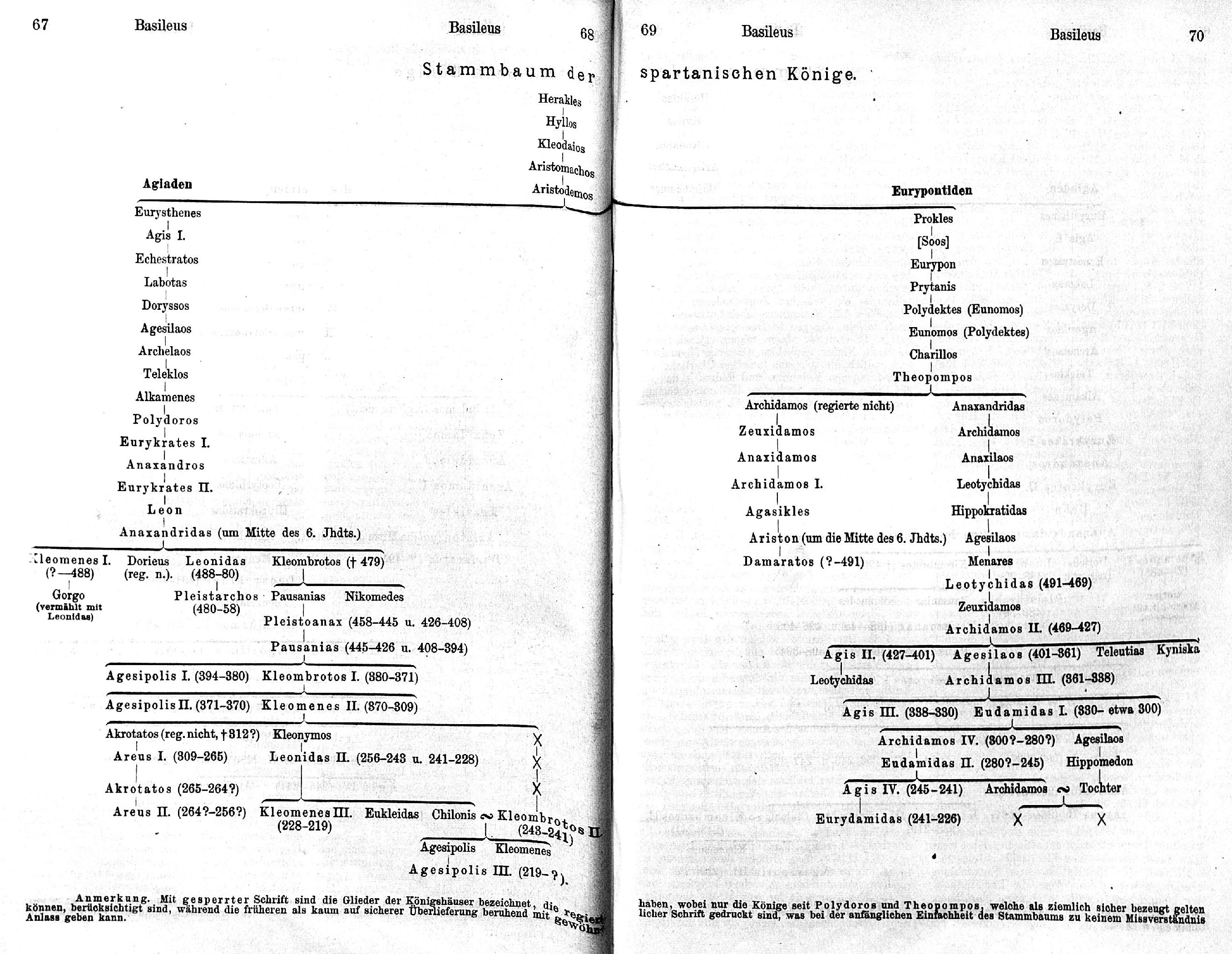
For most of its history, the ancient Greek city-state of Sparta in the Peloponnese was ruled by kings. Sparta was unusual among the Greek city-states in that it maintained its kingship past the Archaic age. It was even more unusual in that it had two kings simultaneously, who were called the ''archagetai'', coming from two separate lines. According to tradition, the two lines, the Agiads (, ) and Eurypontids (, ), were respectively descended from the twins Eurysthenes and Procles, the descendants of Heracles, who supposedly conquered Sparta two generations after the Trojan War. The dynasties themselves, however, were named after the twins' grandsons, the kings Agis I and Eurypon, respectively. The Agiad line was regarded as being senior to the Eurypontid line.Cartledge, Paul, ''The Spartans'', Vintage Books, 2003. Although there are lists of the earlier purported Kings of Sparta, there is little evidence for the existence of any kings before the middle of the sixth century BC or ... [...More Info...] [...Related Items...] OR: [Wikipedia] [Google] [Baidu] |

.jpg)


