|
1991 Protest In Split
The 1991 protest in Split was a street protest against the Yugoslav People's Army (''Jugoslovenska Narodna Armija'' – JNA) held in Split, Croatia on 6 May 1991. The protest was organised by the Croatian Trade Union Association in the Brodosplit Shipyard and joined in by workers from other companies in the city and other residents of Split after radio broadcast appeals for help while the protesters marched through the streets. Ultimately, the protest drew 100,000 supporters. The march ended in a picket in front of the Banovina building, where the JNA had its headquarters in Split at the time. The protesters demanded an end to the JNA-imposed blockade of the village of Kijevo. Scuffles broke out in front of the building, and a JNA soldier was killed by a gunshot reportedly fired from the crowd. Four organisers of the protest were arrested a month later by the JNA, tried in a military court and convicted. They were released months later in a prisoner exchange. The protest ca ... [...More Info...] [...Related Items...] OR: [Wikipedia] [Google] [Baidu] |
Croatian War Of Independence
The Croatian War of Independence was fought from 1991 to 1995 between Croat forces loyal to the Government of Croatia—which had declared independence from the Socialist Federal Republic of Yugoslavia (SFRY)—and the Serb-controlled Yugoslav People's Army (JNA) and local Serb forces, with the JNA ending its combat operations in Croatia by 1992. In Croatia, the war is primarily referred to as the "Homeland War" ( hr, Domovinski rat) and also as the " Greater-Serbian Aggression" ( hr, Velikosrpska agresija). In Serbian sources, "War in Croatia" ( sr-cyr, Рат у Хрватској, Rat u Hrvatskoj) and (rarely) "War in Krajina" ( sr-cyr, Рат у Крајини, Rat u Krajini) are used. A majority of Croats wanted Croatia to leave Yugoslavia and become a sovereign country, while many ethnic Serbs living in Croatia, supported by Serbia, opposed the secession and wanted Serb-claimed lands to be in a common state with Serbia. Most Serbs sought a new Serb state within a Yugos ... [...More Info...] [...Related Items...] OR: [Wikipedia] [Google] [Baidu] |
Socialist Republic Of Croatia
The Socialist Republic of Croatia ( sh-Latn-Cyrl, separator=" / ", Socijalistička Republika Hrvatska, Социјалистичка Република Хрватска), or SR Croatia, was a constituent republic and federated state of the Socialist Federal Republic of Yugoslavia. By its constitution, modern-day Croatia is its direct continuation. Along with five other Yugoslav republics, it was formed during World War II and became a socialist republic after the war. It had four full official names during its 48-year existence ( see below). By territory and population, it was the second largest republic in Yugoslavia, after the Socialist Republic of Serbia. In 1990, the government dismantled the single-party system of government – installed by the League of Communists – and adopted a multi-party democracy. The newly elected government of Franjo Tuđman moved the republic towards independence, formally seceding from Yugoslavia in 1991 and thereby contributing to its disso ... [...More Info...] [...Related Items...] OR: [Wikipedia] [Google] [Baidu] |
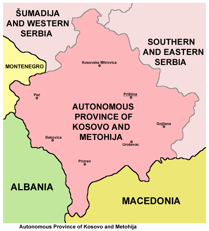
Autonomous Province Of Kosovo And Metohija
The Autonomous Province of Kosovo and Metohija ( sr, Косово и Метохиja, Kosovo i Metohija; sq, Kosova dhe Metohija), commonly known as Kosovo and abbreviated to Kosmet or KiM, is an autonomous province defined by the constitution of Serbia that occupies the southernmost part of Serbia. The territory is the subject of an ongoing political and territorial dispute between Serbia and the partially recognised, self-proclaimed Republic of Kosovo, the latter of which has control over the region. Its claimed administrative capital and largest city is Pristina. The territory of the province, as recognized by Serbian laws, lies in the southern part of Serbia and covers the regions of Kosovo and Metohija. The capital of the province is Pristina. The territory was previously an autonomous province of Serbia during Socialist Yugoslavia (1946–1990), and acquired its current status in 1990. The province was governed as part of Serbia until the Kosovo War (1998–99), when i ... [...More Info...] [...Related Items...] OR: [Wikipedia] [Google] [Baidu] |
Vojvodina
Vojvodina ( sr-Cyrl, Војводина}), officially the Autonomous Province of Vojvodina, is an autonomous province that occupies the northernmost part of Serbia. It lies within the Pannonian Basin, bordered to the south by the national capital Belgrade and the Sava and Danube Rivers. The administrative center, Novi Sad, is the second-largest city in Serbia. The historic regions of Banat, Bačka, and Syrmia overlap the province. Modern Vojvodina is multi-ethnic and multi-cultural, with some 26 ethnic groups and six official languages. About two million people, nearly 27% of Serbia's population, live in the province. Naming ''Vojvodina'' is also the Serbian word for voivodeship, a type of duchy overseen by a voivode. The Serbian Voivodeship, a precursor to modern Vojvodina, was an Austrian province from 1849 to 1860. Its official name is the Autonomous Province of Vojvodina. Its name in the province's six official languages is: * Croatian: ''Autonomna Pokrajina Vojvodina'' * ... [...More Info...] [...Related Items...] OR: [Wikipedia] [Google] [Baidu] |
Socialist Republic Of Montenegro
The Socialist Republic of Montenegro ( sh-Latn-Cyrl, separator=" / ", Socijalistička Republika Crna Gora, Социјалистичка Република Црна Гора), commonly referred to as Socialist Montenegro or simply Montenegro, was one of the six republics forming the Socialist Federal Republic of Yugoslavia and the nation state of the Montenegrins. It is a predecessor of the modern-day Montenegro. Prior to its formation, Montenegro was part of Zeta banovina administrative unit of Kingdom of Yugoslavia. History On 7 July 1963, the ''People's Republic of Montenegro'' (Serbo-Croatian: ''Narodna Republika Crna Gora'' / Народна Република Црна Гора) was renamed the "Socialist Republic of Montenegro" (a change ratified both by the Federal Constitution and the newly created Montenegrin Constitution in 1963) with Serbo-Croatian as the official language. In 1991, as the League of Communists of Montenegro changed its name to Democratic Party of Social ... [...More Info...] [...Related Items...] OR: [Wikipedia] [Google] [Baidu] |
Republic Of Serbia (1990–2006)
Serbia (, ; Serbian: , , ), officially the Republic of Serbia (Serbian: , , ), is a landlocked country in Southeastern and Central Europe, situated at the crossroads of the Pannonian Basin and the Balkans. It shares land borders with Hungary to the north, Romania to the northeast, Bulgaria to the southeast, North Macedonia to the south, Croatia and Bosnia and Herzegovina to the west, and Montenegro to the southwest, and claims a border with Albania through the disputed territory of Kosovo. Serbia without Kosovo has about 6.7 million inhabitants, about 8.4 million if Kosvo is included. Its capital Belgrade is also the largest city. Continuously inhabited since the Paleolithic Age, the territory of modern-day Serbia faced Slavic migrations in the 6th century, establishing several regional states in the early Middle Ages at times recognised as tributaries to the Byzantine, Frankish and Hungarian kingdoms. The Serbian Kingdom obtained recognition by the Holy See and Consta ... [...More Info...] [...Related Items...] OR: [Wikipedia] [Google] [Baidu] |
Eastern Croatia
Slavonia (; hr, Slavonija) is, with Dalmatia, Croatia proper, and Istria, one of the four historical regions of Croatia. Taking up the east of the country, it roughly corresponds with five Croatian counties: Brod-Posavina, Osijek-Baranja, Požega-Slavonia, Virovitica-Podravina, and Vukovar-Syrmia, although the territory of the counties includes Baranya, and the definition of the western extent of Slavonia as a region varies. The counties cover or 22.2% of Croatia, inhabited by 806,192—18.8% of Croatia's population. The largest city in the region is Osijek, followed by Slavonski Brod and Vinkovci. Slavonia is located in the Pannonian Basin, largely bordered by the Danube, Drava, and Sava rivers. In the west, the region consists of the Sava and Drava valleys and the mountains surrounding the Požega Valley, and plains in the east. Slavonia enjoys a moderate continental climate with relatively low precipitation. After the fall of the Western Roman Empire, which ruled the ... [...More Info...] [...Related Items...] OR: [Wikipedia] [Google] [Baidu] |
Banovina (region)
, settlement_type = Geographic region , image_skyline = Banovina-Banija-Банија.jpg , image_caption = Collage of Banovina Photos , image_shield = , shield_size = , image_map = CroatiaSisak-Moslavina.png , map_caption = Banovina on a map of Croatia. Banovina is located in the southern part of Sisak-Moslavina County , subdivision_type = Country , subdivision_name = , seat_type = Largest city , seat = , area_footnotes = , area_total_km2 = 4463 , population_footnotes = , population_total = 183730 , population_as_of = 2001 , population_density_km2 = auto , footnotes = a Banovina is not designated as an official region, it is a geographic region onl ... [...More Info...] [...Related Items...] OR: [Wikipedia] [Google] [Baidu] |
Kordun
The Kordun () region is a part of central Croatia from the bottom of the Petrova Gora (Peter's mountain) mountain range, which extends along the rivers Korana and Slunjčica, and forms part of the border region to Bosnia and Herzegovina. Within Croatia, Kordun is bordered by the Lika region to the south and by Banovina or Banija to the east. Most of Kordun with its centre Slunj belongs to Karlovac County (Slunj, Cetingrad, Krnjak, Rakovica and Vojnić). Vrginmost belongs to Sisak-Moslavina County. In former times, this region belonged to the Habsburg Military Frontier towards the Ottoman Empire. Following the Croatian War of Independence, a number of towns and municipalities in the region were designated Areas of Special State Concern. The area has rich wood resources. Today, the economic situation is slowly improving, but there is still a large tendency of emigration from the region to larger cities. A typical phenomenon of this region is the porous composition of the karst ... [...More Info...] [...Related Items...] OR: [Wikipedia] [Google] [Baidu] |
Lika
Lika () is a traditional region of Croatia proper, roughly bound by the Velebit mountain from the southwest and the Plješevica mountain from the northeast. On the north-west end Lika is bounded by Ogulin-Plaški basin, and on the south-east by the Malovan pass. Today most of the territory of Lika ( Brinje, Donji Lapac, Gospić, Lovinac, Otočac, Perušić, Plitvička Jezera, Udbina and Vrhovine) is part of Lika-Senj County. Josipdol, Plaški and Saborsko are part of Karlovac County and Gračac is part of Zadar County. Major towns include Gospić, Otočac, and Gračac, most of which are located in the karst poljes of the rivers of Lika, Gacka and others. The Plitvice Lakes National Park is also in Lika. History Antiquity Since the first millennium BC the region was inhabited by Iapydes, an ancient people related to Illyrians. During the Gallic invasion of the Balkans, a division of the Gallic army passed through the territory of today's Lika and a part of this army sett ... [...More Info...] [...Related Items...] OR: [Wikipedia] [Google] [Baidu] |
Knin
Knin (, sr, link=no, Книн, it, link=no, Tenin) is a city in the Šibenik-Knin County of Croatia, located in the Dalmatian hinterland near the source of the river Krka, an important traffic junction on the rail and road routes between Zagreb and Split. Knin rose to prominence twice in history, as the capital of both the medieval Kingdom of Croatia and, briefly, of the unrecognized self-proclaimed Republic of Serbian Krajina for the duration of Croatian War of Independence from 1991 to 1995. Etymology The name is likely derived from the Illyrian ''Ninia''. According to an alternative explanation, offered by Franz Miklosich and Petar Skok, the name - derived from a Slavic root ''*tьn-'' ("to cut", "to chop") - has a meaning of "cleared forest". The medieval names of Knin include hu, Tinin; it, Tenin; la, Tinum. The Latin name is still used as a titular episcopal see, the Diocese of Tinum. History Ancient The area consisting of today's Knin, or more specifically, ... [...More Info...] [...Related Items...] OR: [Wikipedia] [Google] [Baidu] |
Dalmatia
Dalmatia (; hr, Dalmacija ; it, Dalmazia; see #Name, names in other languages) is one of the four historical region, historical regions of Croatia, alongside Croatia proper, Slavonia, and Istria. Dalmatia is a narrow belt of the east shore of the Adriatic Sea, stretching from the island of Rab in the north to the Bay of Kotor in the south. The Dalmatian Hinterland ranges in width from fifty kilometres in the north, to just a few kilometres in the south; it is mostly covered by the rugged Dinaric Alps. List of islands of Croatia, Seventy-nine islands (and about 500 islets) run parallel to the coast, the largest (in Dalmatia) being Brač, Pag (island), Pag, and Hvar. The largest city is Split, Croatia, Split, followed by Zadar and Šibenik. The name of the region stems from an Illyrians, Illyrian tribe called the Dalmatae, who lived in the area in classical antiquity. Later it became a Dalmatia (Roman province), Roman province, and as result a Romance languages, Romance culture ... [...More Info...] [...Related Items...] OR: [Wikipedia] [Google] [Baidu] |


.jpg)

