|
1982 Leeds City Council Election
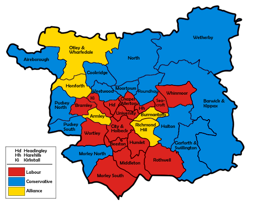
Elections to Leeds City Council were held on Thursday, 6 May 1982, with one-third of the council to be elected. As well as that, there was a vacancy to fill after the defection of Whinmoor incumbent Edward Hewitt to the newly formed Alliance between the Liberal Party and the Labour-breakaway Social Democratic Party in February, following his colleague and Headingley councillor, Ernest Millet, who had also defected to the SDP two months prior. The first election featuring the Alliance seen their support increase by a third upon the previous election, mostly at the expense of the Labour vote, but also helped by the comparative absence of minor parties this election. The Alliance surge resulted in Leeds first three-way race for the popular vote, with the Conservatives pipping Labour by less than 3,000 votes. The large swings from Labour to Alliance produced gains in Burmantofts and Richmond Hill, as well as allowing Conservative gains in Barwick & Kippax, Garforth & Swillington, ... [...More Info...] [...Related Items...] OR: [Wikipedia] [Google] [Baidu] |
Morley, West Yorkshire
Morley is a market town and a civil parish within the City of Leeds metropolitan borough, in West Yorkshire, England. Morley is the largest town in the Borough of Leeds after Leeds itself. Morley forms part of the Heavy Woollen District. It lies approximately south-west of Leeds city centre. It was built on seven hills: Scatcherd Hill, Dawson Hill, Daisy Hill, Chapel Hill, Hunger Hill, Troy Hill and Banks Hill. In 2011, the town and civil parish had populations of 44,440 and 27,738 respectively. The town is split between the Morley North and Morley South wards (containing the town centre) of Leeds City Council, both making up the western half of the Morley and Outwood parliamentary constituency. History Morley was mentioned in the Domesday Book in 1086 as ''Morelege'', ''Morelei'' and ''Moreleia''. Morley means "open ground by a moor", from Old English ''mōr'' "moor, clearing, pasture" + ''lēah'' "open ground, clearing". It gave its name to ''Morelei Wapentac'', a w ... [...More Info...] [...Related Items...] OR: [Wikipedia] [Google] [Baidu] |
Garforth And Swillington (ward)
Garforth and Swillington is an electoral ward of Leeds City Council in east Leeds, West Yorkshire, covering the town of Garforth as well as the villages of Great Preston and Swillington. Boundaries The Garforth and Swillington ward includes the civil parishes of: *Austhorpe Austhorpe is a civil parish and residential suburb of east Leeds, West Yorkshire, England. It is to the east of city centre and close to the A6120 dual carriageway (Leeds Outer Ring Road) and the M1 motorway. Location The area is situated ... (east half) * Great and Little Preston * Sturton Grange * Swillington Councillors indicates seat up for re-election. indicates councillor defection. ''*'' indicates incumbent councillor. Elections since 2010 May 2022 May 2021 May 2019 May 2018 May 2016 May 2015 May 2014 May 2012 May 2011 May 2010 Notes References {{reflist Wards of ... [...More Info...] [...Related Items...] OR: [Wikipedia] [Google] [Baidu] |
Cookridge
Cookridge is a suburb of north-west Leeds, West Yorkshire, England, north of the Leeds Outer Ring Road. In 1715 Ralph Thoresby described it as a village four miles from Leeds and three from Otley, dating from 1540.Ralph Thoresby (1715) ''Ducatus Leodiensis: or, the topography of the ancient and populous town and parish of Leedes, and parts adjacent in the West Riding of York'', pages 157 to 163 A mixture of suburban and council owned properties on the border with Holt Park and Tinshill, the area sits in both the Adel & Wharfedale ward of Leeds City Council and the Leeds North West parliamentary constituency. Before 2004, the area sat within Cookridge ward, named after the area. Nearby places include Adel, Holt Park, Tinshill, Horsforth, Bramhope, Moor Grange and Ireland Wood. Cookridge is one of the highest points in Leeds, with the elevation rising to above sea level close to the water tower on the eastern edge of the suburb. Cookridge holds an annual scarecrow festi ... [...More Info...] [...Related Items...] OR: [Wikipedia] [Google] [Baidu] |
Holbeck
Holbeck is an inner city area of Leeds, West Yorkshire, England. It begins on the southern edge of Leeds city centre and mainly lies in the LS11 postcode district. The M1 and M621 motorways used to end/begin in Holbeck. Now the M621 is the only motorway that passes through the area since the end of the M1 moved to Hook Moor near Aberford. Since large parts of Holbeck have been vacated in preparation for the regeneration of the area, the district has in large parts suffered from a population exodus. Holbeck had a population of 5,505 in 2011. The district currently falls within the Beeston and Holbeck ward of Leeds City Council. The Leeds and Liverpool Canal also runs through Holbeck. History Early history The Hol Beck is the name of a stream running from the south-west into the River Aire.Leodis Hol Beck I ... [...More Info...] [...Related Items...] OR: [Wikipedia] [Google] [Baidu] |
Leeds City Centre
Leeds city centre is the central business district of Leeds, West Yorkshire, England. It is roughly bounded by the Leeds Inner Ring Road, Inner Ring Road to the north and the River Aire to the south and can be divided into several quarters. Central districts Arena Quarter The Arena Quarter is a mixed-use area best known for being the home of the First Direct Arena. Its location is directly north of Merrion Street. The Inner Ring Road borders the district on both the east and north boundary, with Woodhouse Lane acting as the district's western boundary. It is mainly made up of high-rise residential properties and developments, including Sky Plaza and Opal 3. Altus House, Leeds, Altus House is the tallest building in Yorkshire. Other major institutions are located within the Quarter, including the Yorkshire Bank HQ and also the Merrion Centre, Leeds, Merrion Centre. Queen Square is also found here. The Calls The Calls is close to the River Aire. It is directly south of ... [...More Info...] [...Related Items...] OR: [Wikipedia] [Google] [Baidu] |
Chapel Allerton (ward)
Chapel Allerton is an electoral ward of Leeds City Council in north Leeds, West Yorkshire, incorporating the Chapel Allerton, suburb of the same name, Chapeltown, Leeds, Chapeltown, Potternewton and the southern part of the historic area of Scott Hall, Leeds, Scott Hall. Councillors since 1980 indicates seat up for re-election. indicates councillor defection. ''*'' indicates incumbent councillor. Elections since 2010 May 2022 May 2021 May 2019 May 2018 May 2016 May 2015 May 2014 May 2012 May 2011 May 2010 See also *Listed buildings in Leeds (Chapel Allerton Ward) Notes References {{reflist Wards of Leeds ... [...More Info...] [...Related Items...] OR: [Wikipedia] [Google] [Baidu] |
Bramley, Leeds
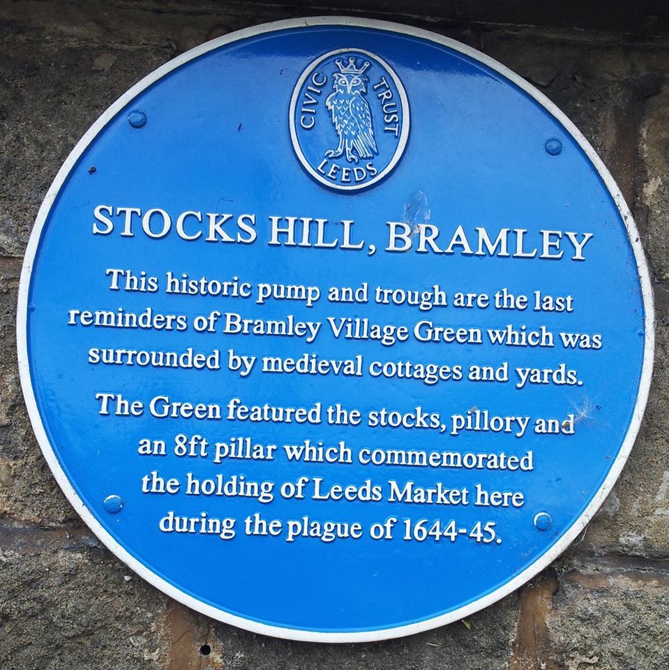
Bramley is a district in west Leeds, West Yorkshire, England. It is part of the City of Leeds Ward of Bramley and Stanningley with a population of 21,334 at the 2011 Census. The area is an old industrial area with much 19th century architecture and 20th century council housing in the east and private suburban housing in the west. Etymology The name of Bramley is first attested in the 1086 Domesday Book as ''Brameleia'' and ''Bramelei''. The name derives from the Old English words ''brōm'' ('broom') and ''lēah'' ('open land in a wood'). Thus the name once meant 'open land characterised by broom'. History At the time of the Domesday survey, the nucleus of the settlement was probably located at Stocks Hill, and it developed in a linear fashion along today's Town Street. The surviving water pump and stone water trough on Stocks Hill remain from Bramley's medieval past. The accompanying blue plaque states "Stocks Hill, Bramley. This historic pump and trough are the l ... [...More Info...] [...Related Items...] OR: [Wikipedia] [Google] [Baidu] |
Michael McGowan (politician)
Michael McGowan (born 19 May 1940) is a British journalist and a former Member of the European Parliament, with a special interest in international affairs, European politics, Africa, peace, development, and human rights. He is a Director of Leeds City Credit Union, and a Director of PAFRAS – Positive Action for Refugees and Asylum Seekers, and until June 2009 was a National Executive Committee member of the Co-operative Party. Background Michael McGowan was born in the village of Birkenshaw in the West Riding of Yorkshire. His father, Edgar, was a baker at Bradford Co-op bakery and his mother, Marion, a waitress. McGowan was educated at Birkenshaw Primary school, Heckmondwike Grammar School, and won a West Riding scholarship to Leicester University where he read History, philosophy, Politics, and Economics. He is married to Margarita and they have three grown up children, Joseph, Emily, and Sebastian. The couple live in Leeds. Political career Michael McGowan was elected a ... [...More Info...] [...Related Items...] OR: [Wikipedia] [Google] [Baidu] |
Beeston, Leeds
Beeston is a suburb of Leeds, West Yorkshire, England located on a hill about 2 miles (3 km) south of the city centre. The origins of Beeston can be traced back to the medieval period. It remained a small settlement until the latter part of the Victorian era when it became a primarily residential area for people working in Leeds and surrounding industrial areas like Holbeck and Hunslet. At the time of the 2011 Census, Beeston had a population of 22,187 (which included Holbeck). Some parts of the area, around Cross Flatts Park, suffer from relatively high levels of deprivation, while areas to the centre and south are generally considered more affluent. Beeston is home to the Leeds United football club stadium on Elland Road and Hunslet rugby league club. Etymology The name ''Beeston'' is first attested in the Domesday Book, in the form ''Bestone''. The name seems to come from Old English *''bēos'' 'bent-grass' (L. Agrostis) and ''tūn'' 'estate, village'. Thus it once m ... [...More Info...] [...Related Items...] OR: [Wikipedia] [Google] [Baidu] |
Armley (ward)
Armley is an electoral ward of Leeds City Council in the west of Leeds, West Yorkshire West Yorkshire is a metropolitan and ceremonial county in the Yorkshire and Humber Region of England. It is an inland and upland county having eastward-draining valleys while taking in the moors of the Pennines. West Yorkshire came into exi ..., covering the district of the same name. Councillors since 1980 indicates seat up for re-election. indicates seat up for election following resignation or death of sitting councillor. indicates councillor defection. ''*'' indicates incumbent councillor. Elections since 2010 May 2022 May 2021 May 2019 May 2018 May 2016 May 2015 May 2014 May 2012 May 2011 May 2010 See also * Listed buildings in Leeds (Armley Ward) Notes References {{Reflist Places in Leeds Wards of Leeds ... [...More Info...] [...Related Items...] OR: [Wikipedia] [Google] [Baidu] |
Aireborough
Aireborough is a district within the West Yorkshire Urban Area, in the West Riding of Yorkshire, England. It is mostly within the present Leeds metropolitan borough, although some areas now in Bradford metropolitan district may also be considered to form part of Aireborough. It includes the settlements of Guiseley, Hawksworth, Menston, High Royds, Nether Yeadon, Rawdon, Yeadon, West Carlton, East Carlton and Esholt. The name ''Aireborough'' is used for a UK census ward, which was named "the most average place in England and Wales", following studies arising from the 2001 census. Etymology The name ''Aireborough'' was first applied to a fictional and wealthy manufacturing town, in short stories written for newspapers of the late nineteenth century by Charles Darcy Friel, who lived and worked in Leeds, and died there in 1910. The name derives from the River Aire, which intersects the West Yorkshire Urban Area. In 1936, the urban councils of Guiseley, Yeadon and Rawdon, ... [...More Info...] [...Related Items...] OR: [Wikipedia] [Google] [Baidu] |


