|
1958 Lituya Bay Megatsunami
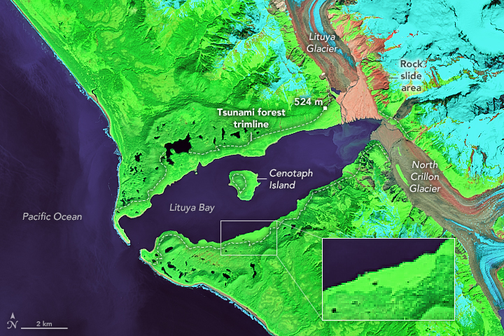
The 1958 Lituya Bay earthquake occurred on PST with a moment magnitude of 7.8 to 8.3 and a maximum Mercalli intensity of XI (''Extreme''). The strike-slip earthquake took place on the Fairweather Fault and triggered a rockslide of 30 million cubic meters (40 million cubic yards) and about 90 million tons into the narrow inlet of Lituya Bay, Alaska. The impact was heard away, and the sudden displacement of water resulted in a megatsunami that washed out trees to a maximum elevation of at the entrance of Gilbert Inlet. This is the largest and most significant megatsunami in modern times; it forced a re-evaluation of large-wave events and the recognition of impact events, rockfalls, and landslides as causes of very large waves. Event outline Lituya Bay is a fjord located on the Fairweather Fault in the northeastern part of the Gulf of Alaska. It is a T-shaped bay with a width of and a length of . Lituya Bay is an ice-scoured tidal inlet with a maximum depth of . The narro ... [...More Info...] [...Related Items...] OR: [Wikipedia] [Google] [Baidu] |
Moment Magnitude Scale
The moment magnitude scale (MMS; denoted explicitly with or Mw, and generally implied with use of a single M for magnitude) is a measure of an earthquake's magnitude ("size" or strength) based on its seismic moment. It was defined in a 1979 paper by Thomas C. Hanks and Hiroo Kanamori. Similar to the local magnitude scale, local magnitude/Richter scale () defined by Charles Francis Richter in 1935, it uses a logarithmic scale; small earthquakes have approximately the same magnitudes on both scales. Despite the difference, news media often says "Richter scale" when referring to the moment magnitude scale. Moment magnitude () is considered the authoritative magnitude scale for ranking earthquakes by size. It is more directly related to the energy of an earthquake than other scales, and does not saturate—that is, it does not underestimate magnitudes as other scales do in certain conditions. It has become the standard scale used by seismological authorities like the U.S. Geological ... [...More Info...] [...Related Items...] OR: [Wikipedia] [Google] [Baidu] |
Gulf Of Alaska
The Gulf of Alaska (Tlingit: ''Yéil T'ooch’'') is an arm of the Pacific Ocean defined by the curve of the southern coast of Alaska, stretching from the Alaska Peninsula and Kodiak Island in the west to the Alexander Archipelago in the east, where Glacier Bay and the Inside Passage are found. The Gulf shoreline is a combination of forest, mountain and a number of tidewater glaciers. Alaska's largest glaciers, the Malaspina Glacier and Bering Glacier, spill out onto the coastal line along the Gulf of Alaska. The coast is heavily indented with Cook Inlet and Prince William Sound, the two largest connected bodies of water. It includes Yakutat Bay and Cross Sound. Lituya Bay (a fjord north of Cross Sound, and south of Mount Fairweather) is the site of the largest recorded tsunami in history. It serves as a sheltered anchorage for fishing boats. Ecology The Gulf of Alaska is considered a Class I, productive ecosystem with more than 300 grams of carbon per square meter per year ... [...More Info...] [...Related Items...] OR: [Wikipedia] [Google] [Baidu] |
Subglacial Lake
A subglacial lake is a lake that is found under a glacier, typically beneath an ice cap or ice sheet. Subglacial lakes form at the boundary between ice and the underlying bedrock, where gravitational pressure decreases the pressure melting point of ice. Over time, the overlying ice gradually melts at a rate of a few millimeters per year. Meltwater flows from regions of high to low hydraulic pressure under the ice and pools, creating a body of liquid water that can be isolated from the external environment for millions of years. Since the first discoveries of subglacial lakes under the Antarctic Ice Sheet, more than 400 subglacial lakes have been discovered in Antarctica, beneath the Greenland Ice Sheet, and under Iceland's Vatnajökull ice cap. Subglacial lakes contain a substantial proportion of Earth's liquid freshwater, with the volume of Antarctic subglacial lakes alone estimated to be about 10,000 km3, or about 15% of all liquid freshwater on Earth. As ecosystems is ... [...More Info...] [...Related Items...] OR: [Wikipedia] [Google] [Baidu] |
Subaerial
In natural science, subaerial (literally "under the air"), has been used since 1833,Subaerial in the Merriam-Webster dictionary. notably in and , to describe features and events occurring or formed on or near the 's land surface. They are thus exposed to Earth's atmosphere. This may be contrasted with '' subaqueous'' events or features located below a water surface, '' [...More Info...] [...Related Items...] OR: [Wikipedia] [Google] [Baidu] |
Lituya Bay Megatsunami
Lituya may refer to: *Lituya Bay, in Alaska, the United States *Lituya Mountain Lituya Mountain is a peak in the Fairweather Range of Alaska, United States, south of Mount Fairweather. Its eastern slopes feed a branch of the Johns Hopkins Glacier, which flows into Glacier Bay. On its western side is a large cirque, shared ..., peak in the Fairweather Range of Alaska, the United States * Lituya Glacier, tidewater glacier in Alaska, the United States * MV ''Lituya'', shuttle ferry for the Alaska Marine Highway System {{disambig ... [...More Info...] [...Related Items...] OR: [Wikipedia] [Google] [Baidu] |
Lituya Bay Megatsunami Diagram (English)
Lituya may refer to: *Lituya Bay, in Alaska, the United States *Lituya Mountain Lituya Mountain is a peak in the Fairweather Range of Alaska, United States, south of Mount Fairweather. Its eastern slopes feed a branch of the Johns Hopkins Glacier, which flows into Glacier Bay. On its western side is a large cirque, shared ..., peak in the Fairweather Range of Alaska, the United States * Lituya Glacier, tidewater glacier in Alaska, the United States * MV ''Lituya'', shuttle ferry for the Alaska Marine Highway System {{disambig ... [...More Info...] [...Related Items...] OR: [Wikipedia] [Google] [Baidu] |
Evidence Of 1958 Lituya Bay Tsunami Still Clearly Visible In 2010
Evidence for a proposition is what supports this proposition. It is usually understood as an indication that the supported proposition is true. What role evidence plays and how it is conceived varies from field to field. In epistemology, evidence is what justifies beliefs or what makes it rational to hold a certain doxastic attitude. For example, a perceptual experience of a tree may act as evidence that justifies the belief that there is a tree. In this role, evidence is usually understood as a private mental state. Important topics in this field include the questions of what the nature of these mental states is, for example, whether they have to be propositional, and whether misleading mental states can still qualify as evidence. In phenomenology, evidence is understood in a similar sense. Here, however, it is limited to intuitive knowledge that provides immediate access to truth and is therefore indubitable. In this role, it is supposed to provide ultimate justifications for b ... [...More Info...] [...Related Items...] OR: [Wikipedia] [Google] [Baidu] |
Whitehorse, Yukon
Whitehorse () is the capital of Yukon, and the largest city in Northern Canada. It was incorporated in 1950 and is located at kilometre 1426 (Historic Mile 918) on the Alaska Highway in southern Yukon. Whitehorse's downtown and Riverdale areas occupy both shores of the Yukon River, which rises in British Columbia and meets the Bering Sea in Alaska. The city was named after the White Horse Rapids for their resemblance to the mane of a white horse, near Miles Canyon, before the river was dammed. Because of the city's location in the Whitehorse valley and relative proximity to the Pacific Ocean, the climate is milder than comparable northern communities such as Yellowknife. At this latitude, winter days are short and summer days have up to about 19 hours of daylight. Whitehorse, as reported by ''Guinness World Records'', is the city with the least air pollution in the world. As of the 2021 Canadian census, the population was 28,201 within city boundaries and 31,913 in the cens ... [...More Info...] [...Related Items...] OR: [Wikipedia] [Google] [Baidu] |
Seattle, Washington
Seattle ( ) is a port, seaport city on the West Coast of the United States. It is the county seat, seat of King County, Washington, King County, Washington (state), Washington. With a 2020 population of 737,015, it is the largest city in both the U.S. state, state of Washington and the Pacific Northwest region of North America. The Seattle metropolitan area's population is 4.02 million, making it the List of metropolitan statistical areas, 15th-largest in the United States. Its growth rate of 21.1% between 2010 and 2020 makes it one of the nation's fastest-growing large cities. Seattle is situated on an isthmus between Puget Sound (an inlet of the Pacific Ocean) and Lake Washington. It is the northernmost major city in the United States, located about south of the Canada–United States border, Canadian border. A major gateway for trade with East Asia, Seattle is the fourth-largest port in North America in terms of container handling . The Seattle area was inhabited by Nat ... [...More Info...] [...Related Items...] OR: [Wikipedia] [Google] [Baidu] |
United States Department Of The Interior
The United States Department of the Interior (DOI) is one of the executive departments of the U.S. federal government headquartered at the Main Interior Building, located at 1849 C Street NW in Washington, D.C. It is responsible for the management and conservation of most federal lands and natural resources, and the administration of programs relating to Native Americans, Alaska Natives, Native Hawaiians, territorial affairs, and insular areas of the United States, as well as programs related to historic preservation. About 75% of federal public land is managed by the department, with most of the remainder managed by the Department of Agriculture's Forest Service. The department was created on March 3, 1849. The department is headed by the secretary of the interior, who reports directly to the president of the United States and is a member of the president's Cabinet. The current secretary is Deb Haaland. Despite its name, the Department of the Interior has a different ro ... [...More Info...] [...Related Items...] OR: [Wikipedia] [Google] [Baidu] |
United States Department Of Commerce
The United States Department of Commerce is an executive department of the U.S. federal government concerned with creating the conditions for economic growth and opportunity. Among its tasks are gathering economic and demographic data for business and government decision making, and helping to set industrial standards. Its main purpose is to create jobs, promote economic growth, encourage sustainable development and block harmful trade practices of other nations.Steve Charnovitz, "Reinventing the Commerce Dept.", ''Journal of Commerce'', July 12, 1995. It is headed by the Secretary of Commerce, who reports directly to the President of the United States and is a member of the president's Cabinet. The Department of Commerce is headquartered in the Herbert C. Hoover Building in Washington, DC. History Organizational history The department was originally created as the United States Department of Commerce and Labor on February 14, 1903. It was subsequently renamed the Departme ... [...More Info...] [...Related Items...] OR: [Wikipedia] [Google] [Baidu] |


.jpeg)

.jpg)
