|
11th Ward Of New Orleans
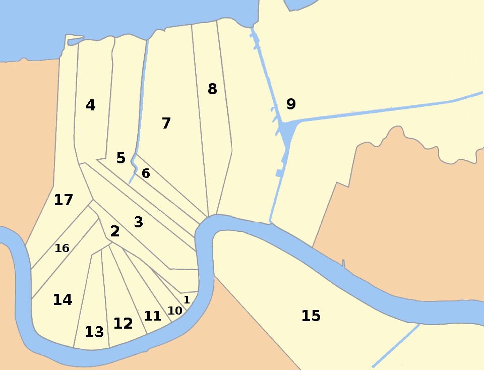
The 11th Ward or Eleventh Ward is a division of the city of New Orleans, Louisiana, USA. The 11th Ward is one of the 17 Wards of New Orleans. New Orleans Districts and Wards The Ward was formerly part of the old Lafayette Faubourg annexed by New Orleans in the 1850s. It is part of Uptown New Orleans. Boundaries The roughly wedge-shaped Ward stretches back from the Mississippi River. The lower boundary is First Street, across which is the 10th Ward, then Martin Luther King Jr. Boulevard (formerly Melpomene Avenue), across which is the 2nd Ward. The upper boundary is Toledano Street, across which is the 12th Ward. A large portion of this ward is in the Garden District. Cityscape and landmarks The Ward includes portions of the Irish Channel, Garden District, most of Faubourg Delassize, and a number of housing projects. Landmarks include Lafayette Cemetery, Commander's Palace, and Thomy Lafon School. The majority of the Magnolia Projects The Magnolia Projects, official ... [...More Info...] [...Related Items...] OR: [Wikipedia] [Google] [Baidu] |
New Orleans, Louisiana
New Orleans ( , ,New Orleans Merriam-Webster. ; french: La Nouvelle-Orléans , es, Nueva Orleans) is a Consolidated city-county, consolidated city-parish located along the Mississippi River in the southeastern region of the U.S. state of Louisiana. With a population of 383,997 according to the 2020 U.S. census, it is the List of municipalities in Louisiana, most populous city in Louisiana and the twelfth-most populous city in the southeastern United States. Serving as a List of ports in the United States, major port, New Orleans is considered an economic and commercial hub for the broader Gulf Coast of the United States, Gulf Coast region of the United States. New Orleans is world-renowned for its Music of New Orleans, distinctive music, Louisiana Creole cuisine, Creole cuisine, New Orleans English, uniq ... [...More Info...] [...Related Items...] OR: [Wikipedia] [Google] [Baidu] |
Wards Of New Orleans
The city of New Orleans, in the U.S. state of Louisiana, is divided into 17 wards. Politically, the wards are used in voting in elections, subdivided into precincts. Under various previous city charters of the 19th century, aldermen and later city council members were elected by ward. The city has not had officials elected to represent wards since 1912, but the ward designations remain a part of New Orleans' fabric. Socially, it is not uncommon for New Orleanians from some wards to identify where they are from by their ward number. History Most of the boundaries of Wards 1 through 11 were drawn in 1852 when the city was reorganized from three separate municipalities into one centralized government. With various changes, these boundaries remain largely the same, and have not changed at all since the 1880s. The rest of the Wards were formed from the expansion of the city boundaries in the 1870s. The 12th, 13th, and 14th Wards were formed by annexation of land up river from the olde ... [...More Info...] [...Related Items...] OR: [Wikipedia] [Google] [Baidu] |
Uptown New Orleans
Uptown is a section of New Orleans, Louisiana, United States, on the east bank of the Mississippi River, encompassing a number of neighborhoods (including the similarly-named and smaller Uptown area) between the French Quarter and the Jefferson Parish line. It remains an area of mixed residential and small commercial properties, with a wealth of 19th-century architecture. It includes part or all of Uptown New Orleans Historic District, which is listed on the National Register of Historic Places. Boundaries and definitions Historically, uptown was a direction, meaning movement in the direction against the flow of the Mississippi. After the Louisiana Purchase, many settlers from other parts of the United States developed their homes and businesses in the area upriver from the older Creole city. During the 19th century Canal Street was known as the dividing line between uptown and downtown New Orleans, the boundary between the predominantly Francophone area downriver and the p ... [...More Info...] [...Related Items...] OR: [Wikipedia] [Google] [Baidu] |
Mississippi River
The Mississippi River is the second-longest river and chief river of the second-largest drainage system in North America, second only to the Hudson Bay drainage system. From its traditional source of Lake Itasca in northern Minnesota, it flows generally south for to the Mississippi River Delta in the Gulf of Mexico. With its many tributaries, the Mississippi's watershed drains all or parts of 32 U.S. states and two Canadian provinces between the Rocky and Appalachian mountains. The main stem is entirely within the United States; the total drainage basin is , of which only about one percent is in Canada. The Mississippi ranks as the thirteenth-largest river by discharge in the world. The river either borders or passes through the states of Minnesota, Wisconsin, Iowa, Illinois, Missouri, Kentucky, Tennessee, Arkansas, Mississippi, and Louisiana. Native Americans have lived along the Mississippi River and its tributaries for thousands of years. Most were hunter-ga ... [...More Info...] [...Related Items...] OR: [Wikipedia] [Google] [Baidu] |
10th Ward Of New Orleans
The 10th Ward is a division of the city of New Orleans, Louisiana. The 10th Ward is one of the 17 wards of New Orleans.11th Ward. Cityscape and landmarks Near the river the ward includes part of the Lower Garden District and the former location of America's first experiment with large-scale public housing, started here in 1937, when, as part of the New Deal, President Franklin D. Roosevelt signed the loan to commence construction of the St. Thomas Development">St. Thomas Housing Project. In Central City New Orleans">Central City it includes the Oretha Castle Haley commercial district. Residents The 10th Ward has been home to such notables as jazz musicians Buddy Bolden and George Brunies History In 1718, the City of New Orleans was established. The city was later divided into many neighborhoods, streets, and squares. Faubourg Lafayette is one of the many neighborhoods of New Orleans. Faubourg Lafayette was united by an act of legislation, prior to being classified as an official n ... [...More Info...] [...Related Items...] OR: [Wikipedia] [Google] [Baidu] |
Martin Luther King Jr
Martin Luther King Jr. (born Michael King Jr.; January 15, 1929 – April 4, 1968) was an American Baptist minister and activist, one of the most prominent leaders in the civil rights movement from 1955 until his assassination in 1968. An African American church leader and the son of early civil rights activist and minister Martin Luther King Sr., King advanced civil rights for people of color in the United States through nonviolence and civil disobedience. Inspired by his Christian beliefs and the nonviolent activism of Mahatma Gandhi, he led targeted, nonviolent resistance against Jim Crow laws and other forms of discrimination. King participated in and led marches for the right to vote, desegregation, labor rights, and other civil rights. He oversaw the 1955 Montgomery bus boycott and later became the first president of the Southern Christian Leadership Conference (SCLC). As president of the SCLC, he led the unsuccessful Albany Movement in Albany, ... [...More Info...] [...Related Items...] OR: [Wikipedia] [Google] [Baidu] |
2nd Ward Of New Orleans
The 2nd Ward or Second Ward of New Orleans, Louisiana is one of the 17 Wards of New Orleans. Boundaries The Ward fronts the . The down-river or "lower" boundary (in this case, to the northeast) is Julia Street, across which is the 3rd Ward. The boundary continues inland from the end of Julia, originally delineated by the , now[...More Info...] [...Related Items...] OR: [Wikipedia] [Google] [Baidu] |
12th Ward Of New Orleans
The 12th Ward or Twelfth Ward is a division of the city of New Orleans, Louisiana, one of the 17 Wards of New Orleans. The Ward was formerly part of the old Jefferson City annexed by New Orleans in 1870. Boundaries The roughly wedge-shaped Ward stretches back from the Mississippi River. The lower boundary is Toledano Street, across which is the 11th Ward; the upper boundary is Napoleon Avenue, across which is the 13th Ward, and the back boundary is South Broad, across which is a portion of the 14th Ward. It includes a section of Uptown New Orleans, part of the Broadmoor neighborhood, and the neighborhoods of Milan and Touro. New Orleans LA (NOLA) Retrieved February 25, 2013 Landmarks Landmarks include |
Garden District, New Orleans
The Garden District is a Neighborhoods in New Orleans, neighborhood of the city of New Orleans, Louisiana, United States. A subdistrict of the Central City/Garden District Area, its boundaries as defined by the New Orleans City Planning Commission are: St. Charles Avenue to the north, 1st Street to the east, Magazine Street to the south, and Toledano Street to the west. The National Historic Landmark district extends a little farther. The area was originally developed between 1832 and 1900 and is considered one of the best-preserved collections of historic mansions in the Southern United States. The 19th-century origins of the Garden District illustrate wealthy newcomers building opulent structures based upon the prosperity of New Orleans in that era. (National Trust, 2006) History This whole area was once a number of Plantations in the American South, plantations, including the Faubourg Livaudais, Livaudais Plantation. It was sold off in parcels to mainly wealthy Americans ... [...More Info...] [...Related Items...] OR: [Wikipedia] [Google] [Baidu] |
Irish Channel, New Orleans
Irish Channel ( French: ''Manche irlandaise'', Irish: ''Cainéal na hÉireann'') is a neighborhood of the city of New Orleans. A subdistrict of the Central City/Garden District Area, its boundaries as defined by thHistoric District Landmarks Commissionare: Magazine Street to the north, Jackson Avenue to the east, the Mississippi River to the south and Delachaise Street to the west. Geography Irish Channel is located at and has an elevation of . According to the United States Census Bureau, the district has a total area of . of which is land and (39.76%) of which is water. Adjacent neighborhoods * East Riverside (west) * Garden District (north) * Lower Garden District (east) * St. Thomas Development (east) * Mississippi River (south) * West Riverside (west) Boundaries The New Orleans City Planning Commission defines the boundaries of the Irish Channel as these streets: Tchoupitoulas Street, Toledano Street, Magazine Street, First Street, the Mississippi River and Napoleo ... [...More Info...] [...Related Items...] OR: [Wikipedia] [Google] [Baidu] |
Lafayette Cemetery
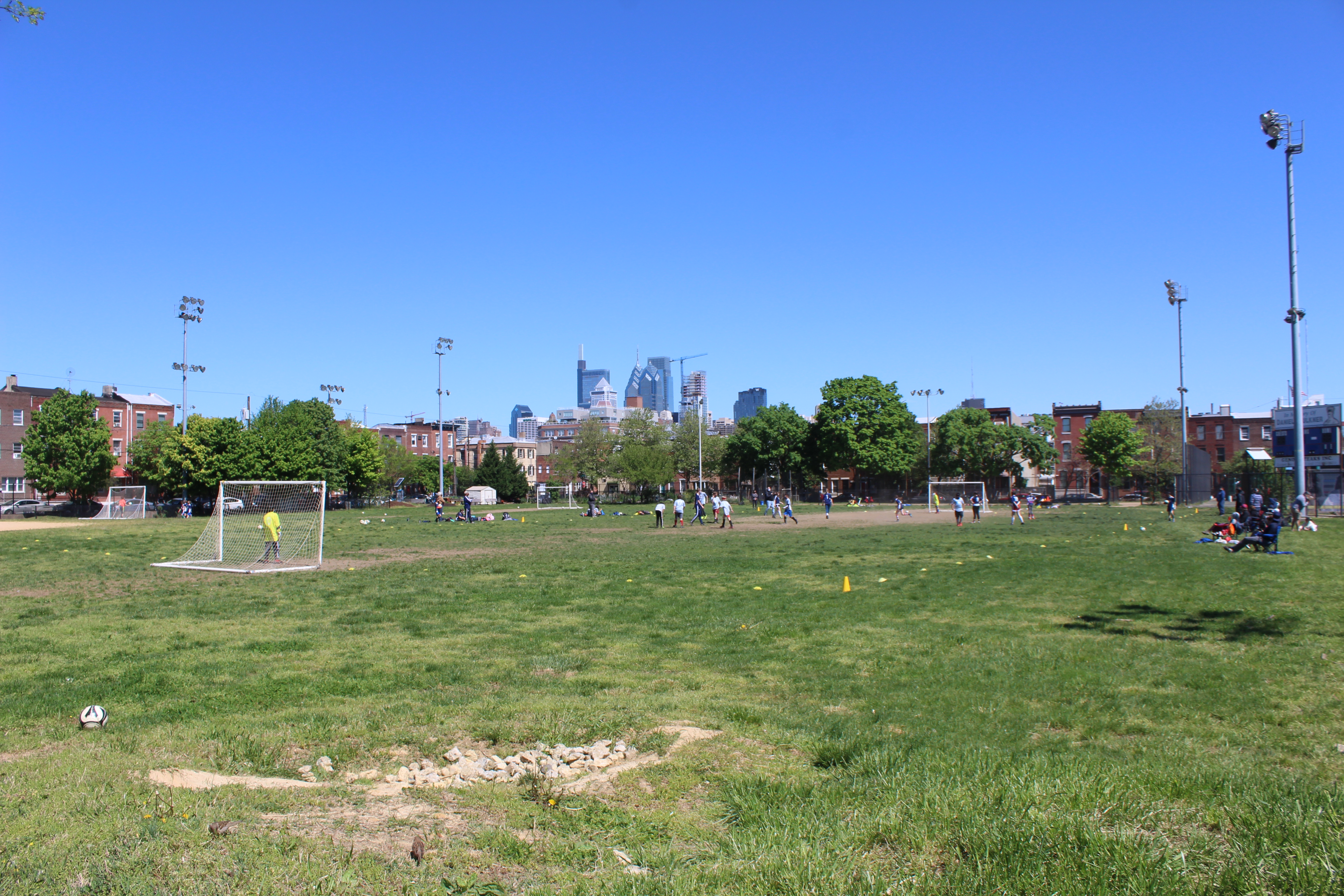
Lafayette Cemetery was a cemetery in the Passyunk Square neighborhood of Philadelphia, Pennsylvania. It was established in 1828 and originally intended for 14,000 burials but over time fell into disrepair and became overcrowded with 47,000 burials. In 1946, the cemetery was condemned by the city of Philadelphia. The bodies were disinterred in 1947, transported to the Evergreen Memorial Park (now Rosedale Cemetery) in Bensalem, Pennsylvania, and reinterred in a mass grave. The former location of the cemetery was repurposed by the city of Philadelphia as the Capitolo Playground. History Lafayette Cemetery was established in 1828 on the block between Federal and Wharton Streets and 9th and 10th Avenues in what was then Passyunk Township, later renamed the Passyunk Square neighborhood of Philadelphia, Pennsylvania. The Honorable Joel Barlow Sutherland was one of the founders. Lafayette Cemetery was a part of the United States National Cemetery System during the American Ci ... [...More Info...] [...Related Items...] OR: [Wikipedia] [Google] [Baidu] |


