Whetstone, London on:
[Wikipedia]
[Google]
[Amazon]
Whetstone is a suburb of north London, in the
John Heathfield, ''Friern Barnet Newsletter'', No. 57 (April 2014), p. 4. It the northernmost settlement in the

 John Heathfield of the Friern Barnet & District Local History Society writes that according to the
London Borough of Barnet
The London Borough of Barnet () is a suburban London boroughs, London borough in north London, England. Forming part of Outer London, the borough was formed in 1965 from parts of the ceremonial counties of Middlesex and Hertfordshire. It is the ...
, bearing the postcode N20. It is served by an Underground station called Totteridge and Whetstone (Totteridge
Totteridge is a residential area and former village in the London Borough of Barnet, England. It is a mixture of suburban development and open land (including some farmland) situated 8 miles (13 km) north north-west of Charing Cross. It ...
being to the west of Whetstone). Whetstone is around 7.8 miles north of Charing Cross
Charing Cross ( ) is a junction in Westminster, London, England, where six routes meet. Since the early 19th century, Charing Cross has been the notional "centre of London" and became the point from which distances from London are measured. ...
. Prior to 1965 it was part of the Borough of Finchley.
The High Road is the A1000, formerly known as the Great North Road, parts of it still bear this name. Until the late 19th century its tiny developed area was one of two main settlements in the ancient parish of Friern Barnet
Friern Barnet () is a suburban area within the London Borough of Barnet, north of Charing Cross. Its centre is formed by the busy intersection of Colney Hatch Lane (running north and south), Woodhouse Road (taking westbound traffic towards No ...
, the other being Colney Hatch
Colney Hatch () is the historical name for a small district within the London Borough of Barnet in London, England. Colney Hatch refers to a loosely defined area centred on the northern end of Colney Hatch Lane (B550), which connects Friern ...
. It was thus the northernmost settlement in the Ossulstone
Ossulstone is an obsolete subdivision (hundred) covering 26.4% of – and the most metropolitan part – of the historic county of Middlesex, England.British History Online �Hundreds of Middlesex/ref> It surrounded but did not includ ...
hundred. Whetstone is also the northernmost part of the parish of Finchley.
History
Early history
In medieval times theHospitallers
The Order of Knights of the Hospital of Saint John of Jerusalem, commonly known as the Knights Hospitaller (), is a Catholic military order. It was founded in the crusader Kingdom of Jerusalem in the 12th century and had headquarters there ...
had a settlement nearby in Friern Barnet probably where Friary Park is now and alongside the old road to London. In 1340 the Bishop of London opened a gate into his park (the Highgate) which enabled a straight road across Finchley Common along the ridge there. The Hospitallers' settlement moved further west and became known as West Town, also known variously as "le Weston" (1398), "Wheston" (1417), and "Whetstonestret" (1439)."Whetstone Notes"John Heathfield, ''Friern Barnet Newsletter'', No. 57 (April 2014), p. 4. It the northernmost settlement in the
Ossulstone
Ossulstone is an obsolete subdivision (hundred) covering 26.4% of – and the most metropolitan part – of the historic county of Middlesex, England.British History Online �Hundreds of Middlesex/ref> It surrounded but did not includ ...
hundred.
Until the late 19th century its tiny developed area was one of two main settlements in the ancient parish of Friern Barnet
Friern Barnet () is a suburban area within the London Borough of Barnet, north of Charing Cross. Its centre is formed by the busy intersection of Colney Hatch Lane (running north and south), Woodhouse Road (taking westbound traffic towards No ...
, the other being Colney Hatch
Colney Hatch () is the historical name for a small district within the London Borough of Barnet in London, England. Colney Hatch refers to a loosely defined area centred on the northern end of Colney Hatch Lane (B550), which connects Friern ...
. Friern Barnet remained its ecclesiastical parish and its civil form was at that time giving way to urban and rural districts, in this case Friern Barnet Urban District
Friern Barnet Urban District was a local government area in Middlesex, England created in 1883 from the civil parish Friern Barnet. It was succeeded by the London Borough of Barnet in 1965 as one of the smaller of its contributory predecessor di ...
.
The Whetstone

Royal Commission on the Historical Monuments of England
Royal may refer to:
People
* Royal (name), a list of people with either the surname or given name
* A member of a royal family or royalty
Places United States
* Royal, Arkansas, an unincorporated community
* Royal, Illinois, a village
* Royal ...
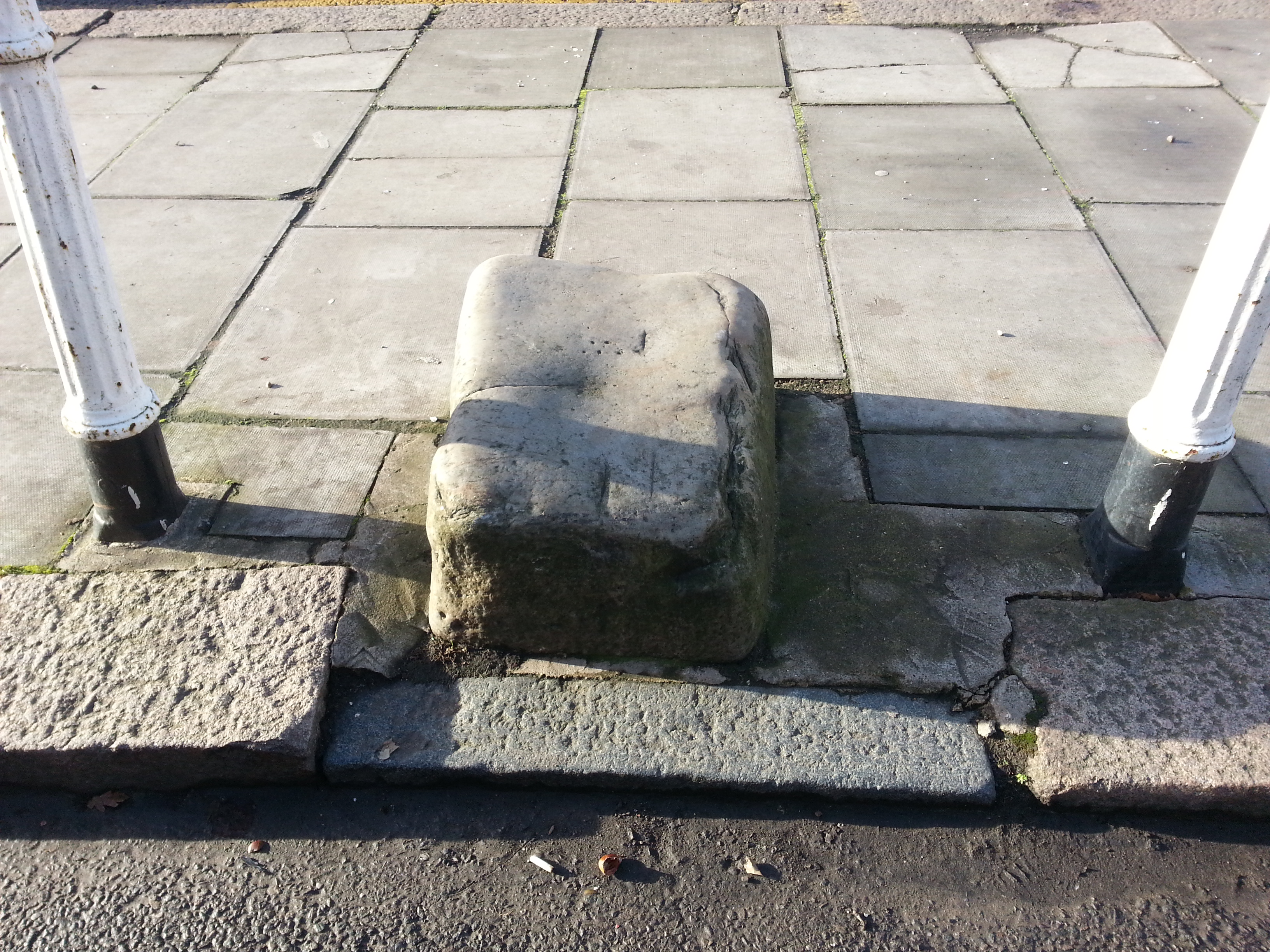
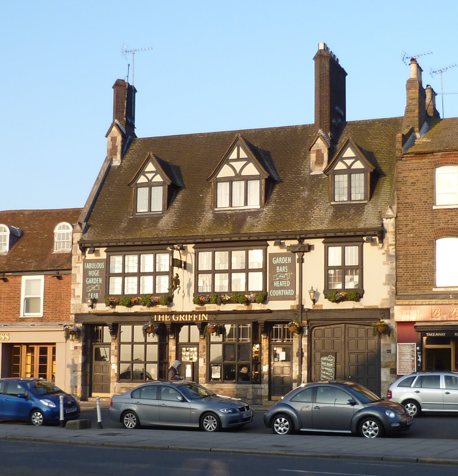
, the stone outside ''The Griffin'' public house
A pub (short for public house) is in several countries a drinking establishment licensed to serve alcoholic drinks for consumption Licensing laws of the United Kingdom#On-licence, on the premises. The term first appeared in England in the ...
commonly known as the Whetstone, is a mounting block
A mounting block, horse block, carriage stone, or in Scots language, Scots a loupin'-on stane is an assistance for mounting and dismounting a horse or cart.
Usage and locations
Mounting blocks were especially useful for women riding sidesaddle ...
, and if so "it would have been connected to the toll gate erected by the Whetstone & Highgate Turnpike Trust about 1730."
An historic legend regarding the whetstone itself tells that the stone was used by soldiers on their march towards High Barnet (approx. 3.5 miles north of Whetstone) in preparation for the battle of Barnet in 1471.
He also states that the earliest evidence for the existence of the stone is a photograph taken in 1861 which shows it much closer to ''The Griffin'' than it is now. The stone was moved to its present location when the toll gate was removed in 1863.
Until the late 19th century this was the northern hamlet, centred on a crossroads, of the medieval parish of Friern Barnet which stretched south-southeast and was half as wide as long. The very rural parish until then had one other main population centre, equally a hamlet, Colney Hatch
Colney Hatch () is the historical name for a small district within the London Borough of Barnet in London, England. Colney Hatch refers to a loosely defined area centred on the northern end of Colney Hatch Lane (B550), which connects Friern ...
.A P Baggs, Diane K Bolton, M A Hicks and R B Pugh, 'Friern Barnet: Introduction', in ''A History of the County of Middlesex: Volume 6'' ed. T F T Baker and C R Elrington (London, 1980), pp. 6-15. Part of the Victoria County History
The Victoria History of the Counties of England, commonly known as the Victoria County History (VCH), is an English history project which began in 1899 with the aim of creating an encyclopaedic history of each of the historic counties of Englan ...
collaborative professional historians' project. British History Online http://www.british-history.ac.uk/vch/middx/vol6/pp6-15
Geography
Whetstone is the northernmost part of the Finchley plateau. Whetstone lies about above sea level.Swan Lane Open Space
Swan Lane Open Space is a public park in Whetstone in the London Borough of Barnet. It is the smallest of Barnet's sixteen "Premier Parks". It has a children's playground, a café, and a pond which was formerly used for model boating but is now ...
is a park in south Whetstone and the Dollis Valley Greenwalk
The Dollis Valley Greenwalk (or Green Walk) is a footpath route in the London Borough of Barnet in London, England, between Moat Mount Nature Reserve in Mill Hill and Hampstead Heath. The route is designed to act as a link between the Capital Ri ...
along the bank of Dollis Brook
Dollis Brook is a waterway which runs through Barnet in north London. It is a tributary of the River Brent, which is itself a tributary of the River Thames.
The Dollis Valley Greenwalk follows almost all of Dollis Brook, apart from a short se ...
passes through it.
Transport
Whetstone has transport links with a national rail station on the Welwyn Garden City branch of the Thameslink network (Oakleigh Park Station, approx. 1 mile East of Whetstone high road), a TFL London underground station (Totteridge and Whetstone) and numerous TFL buses headed towards Walthamstow, Highbury, High Barnet, Brent Cross, Arnos Grove, Highgate, Muswell Hill, Edgware, Winchmore Hill, Trafalgar Square and Colindale. Buses that serve Whetstone include the 125 from Winchmore Hill to Colindale, the 234 from Barnet, The Spires to Archway, the 263 from Barnet Hospital to Highbury Barn, the 383 from High Barnet to Finchley Memorial Hospital via Friary Park, the 34 from Walthamstow to Barnet Church, the 251 from Arnos Grove to Edgware, the 326 from Brent Cross to High Barnet and the N20 from High Barnet to Trafalgar Square. Stations in the area are: * Totteridge and Whetstone (Northern line
The Northern line is a London Underground line that runs between North London and South London. It is printed in black on the Tube map. It carries more passengers per year than any other Underground linearound 340million in 2019making it the bu ...
)
* Oakleigh Park
Oakleigh Park is a loosely defined district in the north of the London Borough of Barnet. It adjoins Whetstone, and is often regarded as part of either that district or of East Barnet, although the East Coast Main Line forms a border with the l ...
Thameslink
See also
* Green Man, WhetstoneReferences
External links
{{Authority control Areas of London Districts of the London Borough of Barnet Places formerly in Middlesex Finchley District centres of London