Vitim (river) on:
[Wikipedia]
[Google]
[Amazon]
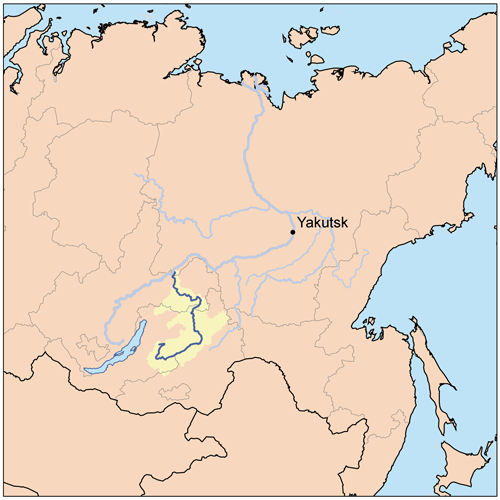
 The Vitim (; , ; , ; Buryat and , ''Vitim'') is a major
 Going upstream: Vitim town where the Vitim joins the Lena. Mama and Mama Airport, about south of Vitim. A muscovite mica mine from 1705 until the late 1930s. Now a small settlement. Mamakan, on a west-flowing stretch south-southeast of Vitim. In 1963 a 86MW dam on the Mamakan River was completed, one of the first dams built on permafrost.Mamakan reservoir - Water of Russia
/ref>
A scary road bridge over the Vitim next to the BAM railway bridge
at ] {{Authority control Rivers of Irkutsk Oblast Rivers of Buryatia
 The Vitim (; , ; , ; Buryat and , ''Vitim'') is a major
 tributary
A tributary, or an ''affluent'', is a stream or river that flows into a larger stream (''main stem'' or ''"parent"''), river, or a lake. A tributary does not flow directly into a sea or ocean. Tributaries, and the main stem river into which they ...
of the Lena. Its source
Source may refer to:
Research
* Historical document
* Historical source
* Source (intelligence) or sub source, typically a confidential provider of non open-source intelligence
* Source (journalism), a person, publication, publishing institute ...
is east of Lake Baikal
Lake Baikal is a rift lake and the deepest lake in the world. It is situated in southern Siberia, Russia between the Federal subjects of Russia, federal subjects of Irkutsk Oblast, Irkutsk Oblasts of Russia, Oblast to the northwest and the Repu ...
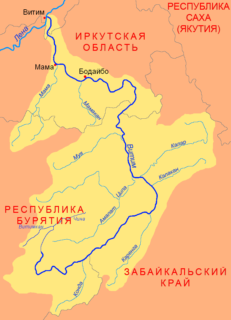
, at the confluence of rivers Vitimkan from the west and China from the east. The Vitim flows first south, bends eastwards and then northward in the Vitim Plateau. Then it flows north through the Stanovoy Highlands
The Stanovoy Highlands () or Stanovoy Uplands is a mountain range in the Transbaikal region of Siberia, Russia.
Geography
The Stanovoy Highlands are a mountainous area between the Patom Highlands to the north and the Vitim Plateau to the south. ...
and the town of Bodaybo
Bodaybo ( rus, Бодайбо, p=bədɐjˈbo) is a town and the administrative center of Bodaybinsky District in Irkutsk Oblast, Russia. It is located from Irkutsk, the administrative center of the oblast.
Geography
The town is located in th ...
.
Including river Vitimkan, its western source, it is long, and has a drainage basin of .Витим (река в Бурят. АССР)Great Soviet Encyclopedia
The ''Great Soviet Encyclopedia'' (GSE; , ''BSE'') is one of the largest Russian-language encyclopedias, published in the Soviet Union from 1926 to 1990. After 2002, the encyclopedia's data was partially included into the later ''Great Russian Enc ...
It is navigable from the Lena to Bodaybo. Upstream, tugs can haul barges as far as the Baikal Amur Mainline
Lake Baikal is a rift lake and the deepest lake in the world. It is situated in southern Siberia, Russia between the Federal subjects of Russia, federal subjects of Irkutsk Oblast, Irkutsk Oblasts of Russia, Oblast to the northwest and the Repu ...
(BAM), but this is becoming rare.
The Vitim is an excellent place for adventure rafting, but is rarely visited because of its isolation. Baissa
The Zaza Formation is a geological formation located in Buryatia (Russia). It dates to the Lower Cretaceous. The age of the formation is disputed, and is considered likely to be Valanginian-Hauterivian, or Aptian in age. It comprises sandstones, ...
, one of the famous localities of fossil insects is situated on the left bank of the Vitim River.
History
The first Russian to explore the river was probablyMaksim Perfilyev
Maksim Perfilyev ( (b. 1580 – d. 1638) was a Cossack explorer of Eastern Siberia and the first Russian to reach Transbaikalia. He was renowned for his diplomatic skills in negotiations with Tunguses, Mongols and Chinese.
In 1618–19 Perf ...
in 1639–40, who brought back reports of the upper Amur River
The Amur River () or Heilong River ( zh, s=黑龙江) is a perennial river in Northeast Asia, forming the natural border between the Russian Far East and Northeast China (historically the Outer and Inner Manchuria). The Amur ''proper'' is ...
.
Formerly, because of its swift current, goods were hauled overland from Chita to Romanovka. There boats were built, floated down the river, and broken up at their destination. This lasted until the late 1940s.
Vitim impact event
The Vitim event occurred in the Vitim River basin nearBodaybo
Bodaybo ( rus, Бодайбо, p=bədɐjˈbo) is a town and the administrative center of Bodaybinsky District in Irkutsk Oblast, Russia. It is located from Irkutsk, the administrative center of the oblast.
Geography
The town is located in th ...
on 25 September 2002. The event was probably caused by a bolide
A bolide is normally taken to mean an exceptionally bright meteor, but the term is subject to more than one definition, according to context. It may refer to any large Impact crater, crater-forming body, or to one that explodes in the atmosphere. ...
. The event was similar to Tagish Lake
Tagish Lake is a lake in Yukon and northern British Columbia, Canada. The lake is long and averages wide with an area of , about two thirds of which is in British Columbia. The average depth is and maximum depth is .
It has two arms, the Ta ...
.
Course
 Going upstream: Vitim town where the Vitim joins the Lena. Mama and Mama Airport, about south of Vitim. A muscovite mica mine from 1705 until the late 1930s. Now a small settlement. Mamakan, on a west-flowing stretch south-southeast of Vitim. In 1963 a 86MW dam on the Mamakan River was completed, one of the first dams built on permafrost.Mamakan reservoir - Water of Russia
/ref>
Bodaybo
Bodaybo ( rus, Бодайбо, p=bədɐjˈbo) is a town and the administrative center of Bodaybinsky District in Irkutsk Oblast, Russia. It is located from Irkutsk, the administrative center of the oblast.
Geography
The town is located in th ...
, just upstream, a gold mining center founded in 1864. Upstream, the port of Luzhki was the start of a road to the Lena gold fields. From here upstream the river goes crookedly east and then south. About upstream from Bodaybo are the Delyun-Uran Rapids and after more, the Parama Rapids. About or so upstream, the Vitim is crossed by the Baikal Amur Mainline
Lake Baikal is a rift lake and the deepest lake in the world. It is situated in southern Siberia, Russia between the Federal subjects of Russia, federal subjects of Irkutsk Oblast, Irkutsk Oblasts of Russia, Oblast to the northwest and the Repu ...
between Taksimo
Taksimo (; Buryat and , ''Taksimo'') is an urban locality (an urban-type settlement) and the administrative center of Muysky District of the Republic of Buryatia, Russia, located on the Muya River on the Muysk Plateau in the far northeast of th ...
and Kuanda. Upriver there are more rapids and goldfields. South through the Stanovoy Mountains toward Chita, then west into the Vitim Plateau east of Lake Baikal
Lake Baikal is a rift lake and the deepest lake in the world. It is situated in southern Siberia, Russia between the Federal subjects of Russia, federal subjects of Irkutsk Oblast, Irkutsk Oblasts of Russia, Oblast to the northwest and the Repu ...
.Yates and Zvegentzov,'Siberian BAM Guide',2001 The river peaks in June and freezes from November to May.
Tributaries
The main tributaries of the Vitim are, from source to mouth: * Konda (right) * Karenga (right) *Kalakan
Kalakan , is a village located in the center of Kalakan District, Kabul Province, Afghanistan.
Notable People of Kalakan
* Habibullāh Kalakāni, Afghan revolutionary leader who deposed the Barakzai Dynasty and captured vast swathes of Afgha ...
(right)
* Kalar (right)
* Tsipa
The Tsipa () is the largest tributary of the Vitim in Buryatia, Russia. It is long, and has a drainage basin of . Maksim Perfilyev was the first Russian to reach the Tsipa in 1640.
Perch, pike, lenok, grayling, taimen and whitefish are also ...
(left)
* Bambuyka
The Bambuyka () is a river in Buryatia, southern East Siberia, Russia. It is long, and has a drainage basin of .
The only inhabited place in the area is Bambuyka, Muysky District, a small hamlet located close to the mouth of the river.Googl ...
(right)
* Muya (left)
* Kuanda
The Kuanda (), also known as Konda, is a river in Zabaykalsky Krai, southern East Siberia, Russia. It is long, and has a drainage basin of .
The river flows across sparsely inhabited areas of the Kalarsky District.Google Earth
Course
The Ku ...
(left)
* Bodaybo
Bodaybo ( rus, Бодайбо, p=bədɐjˈbo) is a town and the administrative center of Bodaybinsky District in Irkutsk Oblast, Russia. It is located from Irkutsk, the administrative center of the oblast.
Geography
The town is located in th ...
(right)
* Mamakan (left)
* Mama
Mama(s) or Mamma or Momma may refer to:
Roles
*Mother, a female parent
* Mama-san, in Japan and East Asia, a woman in a position of authority
*Maternal uncle, in some parts of South Asia
Places
* Mama, Russia, an urban-type settlement in the Mam ...
(left)
See also
*List of rivers of Russia
Russia can be divided into a European and an Asian part. The dividing line is generally considered to be the Ural Mountains. The European part is drained into the Arctic Ocean, Baltic Sea, Black Sea, and Caspian Sea. The Asian part is drained i ...
*Patom Highlands
The Patom Highlands () are a mountainous area in Eastern Siberia, Russia. Administratively most of the territory of the uplands is part of Irkutsk Oblast, with a smaller section in northern Zabaykalsky Krai.Google Earth
There are large deposits o ...
*Selenga Highlands
The Selenga Highlands () are a mountainous area in Buryatia and the southwestern end of Zabaykalsky Krai, Russia.
The Highlands are named after the Selenga River. Protected areas in the Highlands include the Baikal Nature Reserve and the Altach ...
*Southern Muya Range
The Southern Muya Range () is a mountain range in Buryatia and Zabaykalsky Krai, Russia, part of the Stanovoy Highlands. The highest point of the range is 3,067 m high Muisky Gigant; another important peak is 2363 m high Mount Shaman. Google Earth ...
*Vitimsky HPP Cascade The Vitimsky Hydroelectric Power Plant (HPP) Cascade is a proposed group of hydropower plants on the Vitim River in the Buryatia and Irkutsk regions of Russia.
The first stage consists of the proposed Mokskaya HPP, with a planned capacity of 1,200 ...
References
External links
A scary road bridge over the Vitim next to the BAM railway bridge
at ] {{Authority control Rivers of Irkutsk Oblast Rivers of Buryatia