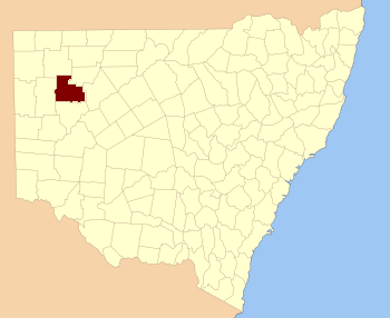
Tully (Parish), New South Wales on:
[Wikipedia]
[Google]
[Amazon]
 Tully Parish, New South Wales in
Final Revised Paper
'' is almost unpopulated, with less than two inhabitants per square kilometer.NASA Earth Observations: Population Density”. NASA/SEDAC.
Central Darling Shire
Central Darling Shire is a local government area in the Far West region of New South Wales, Australia. The Shire is located adjacent to the Barrier Highway. Central Darling Shire was constituted in 1959 and at , it is the largest incorporated lo ...
is a remote rural locality
In general, a rural area or a countryside is a geographic area that is located outside towns and cities. Typical rural areas have a low population density and small settlements. Agricultural areas and areas with forestry are typically describ ...
and civil parish
In England, a civil parish is a type of administrative parish used for local government. It is a territorial designation which is the lowest tier of local government. Civil parishes can trace their origin to the ancient system of parishes, w ...
of Yungnulgra County in far North West New South Wales
New South Wales (commonly abbreviated as NSW) is a States and territories of Australia, state on the Eastern states of Australia, east coast of :Australia. It borders Queensland to the north, Victoria (state), Victoria to the south, and South ...
.
The Parish has an arid
Aridity is the condition of geographical regions which make up approximately 43% of total global available land area, characterized by low annual precipitation, increased temperatures, and limited water availability.Perez-Aguilar, L. Y., Plata ...
landscape
A landscape is the visible features of an area of land, its landforms, and how they integrate with natural or human-made features, often considered in terms of their aesthetic appeal.''New Oxford American Dictionary''. A landscape includes th ...
and the nearest town is Whitecliffs. The parish has extremely hot summer
Summer or summertime is the hottest and brightest of the four temperate seasons, occurring after spring and before autumn. At or centred on the summer solstice, daylight hours are the longest and darkness hours are the shortest, with day ...
s and mild winter
Winter is the coldest and darkest season of the year in temperate and polar climates. It occurs after autumn and before spring. The tilt of Earth's axis causes seasons; winter occurs when a hemisphere is oriented away from the Sun. Dif ...
s. The annual average rainfall
Rain is a form of precipitation where water droplets that have condensed from atmospheric water vapor fall under gravity. Rain is a major component of the water cycle and is responsible for depositing most of the fresh water on the Earth. ...
is about which would make it a semi-arid climate
A semi-arid climate, semi-desert climate, or steppe climate is a dry climate sub-type. It is located on regions that receive precipitation below potential evapotranspiration, but not as low as a desert climate. There are different kinds of se ...
except that its high evapotranspiration
Evapotranspiration (ET) refers to the combined processes which move water from the Earth's surface (open water and ice surfaces, bare soil and vegetation) into the Atmosphere of Earth, atmosphere. It covers both water evaporation (movement of w ...
, or its aridity, makes it a desert climate
The desert climate or arid climate (in the Köppen climate classification ''BWh'' and ''BWk'') is a dry climate sub-type in which there is a severe excess of evaporation over precipitation. The typically bald, rocky, or sandy surfaces in desert ...
. The parish has a Köppen climate classification
The Köppen climate classification divides Earth climates into five main climate groups, with each group being divided based on patterns of seasonal precipitation and temperature. The five main groups are ''A'' (tropical), ''B'' (arid), ''C'' (te ...
of BWh (Hot desert),. ''(directFinal Revised Paper
'' is almost unpopulated, with less than two inhabitants per square kilometer.
References
Localities in New South Wales {{NewSouthWales-geo-stub