Torwood on:
[Wikipedia]
[Google]
[Amazon]
Torwood () is a small village located north-northwest of
 The Forresters used to own the lands of Torwood and
Larbert
Larbert (, ) is a town in the Falkirk (council area), Falkirk council area of Scotland. The town lies in the Forth Valley above the River Carron (Forth), River Carron which flows from the west. Larbert is from the shoreline of the Firth of Fo ...
, north-west of Falkirk
Falkirk ( ; ; ) is a town in the Central Lowlands of Scotland, historically within the county of Stirlingshire. It lies in the Forth Valley, northwest of Edinburgh and northeast of Glasgow.
Falkirk had a resident population of 32,422 at the ...
and south-southeast of Stirling
Stirling (; ; ) is a City status in the United Kingdom, city in Central Belt, central Scotland, northeast of Glasgow and north-west of Edinburgh. The market town#Scotland, market town, surrounded by rich farmland, grew up connecting the roya ...
. Torwood lies within the Falkirk Council
Falkirk ( ; ; ) is one of 32 unitary authority council areas of Scotland. It was formed on 1 April 1996 by way of the Local Government etc. (Scotland) Act 1994 from the exact boundaries of Falkirk District, one of three parts of the Central ...
area of Scotland
Scotland is a Countries of the United Kingdom, country that is part of the United Kingdom. It contains nearly one-third of the United Kingdom's land area, consisting of the northern part of the island of Great Britain and more than 790 adjac ...
. The population recorded in the 2011 UK Census
A census of the population of the United Kingdom is taken every ten years. The 2011 census was held in all countries of the UK on 27 March 2011. It was the first UK census which could be completed online via the Internet. The Office for National ...
was 245.
The A9 road
This is a list of roads designated A9.
* A009 road (Argentina), a road in the northeast of Santa Fe Province
* ''A9 highway (Australia)'' may refer to :
** A9 (Sydney), a road linking Windsor and Campbelltown
** Port River Expressway, a limi ...
between Bannockburn
Bannockburn () is an area immediately south of the centre of Stirling in Scotland. It is part of the City of Stirling. It is named after the Bannock Burn, a stream running through the town before flowing into the River Forth.
History
Land in ...
and Camelon
Camelon (; , ) is a large settlement within the Falkirk council area, Scotland. The village is in the Forth Valley, west of Falkirk, south of Larbert and east of Bonnybridge. The main road through Camelon is the A803 road which links th ...
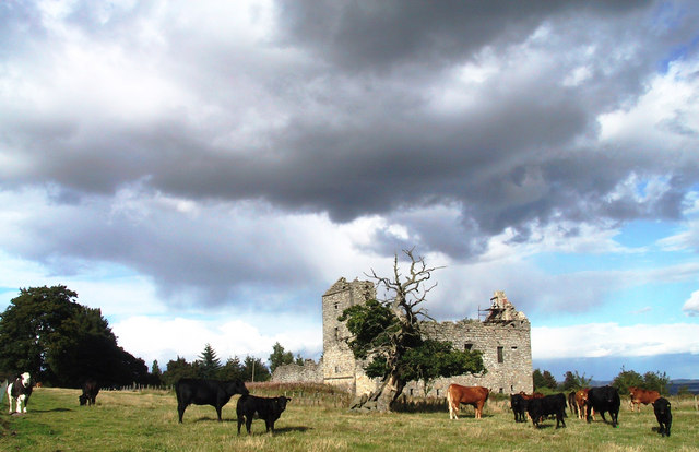
runs through the village. Torwood Has 5 streets: Provost Gardens, Stirling Road, Castle Crescent, Forester Gait & Glen Road. Glen Road leads on to Torwood Castle
Torwood Castle is a ruined 16th-century L-plan castle near the village of Torwood, in the Falkirk Council area of central Scotland. It was designated as a Category A listed building in 1979. The Buildings at Risk Register for Scotland originall ...
, Quarry and Broch.
History
 The Forresters used to own the lands of Torwood and
 Torwood Castle
Torwood Castle is a ruined 16th-century L-plan castle near the village of Torwood, in the Falkirk Council area of central Scotland. It was designated as a Category A listed building in 1979. The Buildings at Risk Register for Scotland originall ...
but now a private trust owns the castle. Forrester Gait was named after the family.
The Torwood was a large forested area in the 12th century stretching from the River Carron west and north towards Stirling, and inland towards the Campsie Hills. It was traversed by an old Roman Road at this time. In preparation for the Battle of Bannockburn
The Battle of Bannockburn ( or ) was fought on 23–24 June 1314, between the army of Robert the Bruce, King of Scots, and the army of King Edward II of England, during the First War of Scottish Independence. It was a decisive victory for Ro ...
, it was used as the encampment for the men of Sir James Douglas, one of the leaders of the army of King Robert the Bruce.
References