Sunda Arc on:
[Wikipedia]
[Google]
[Amazon]
 The Sunda Arc is a

 The main-arc volcanism along Sunda is mainly derived from the interaction between the Indo-Australian Plate and the Eurasia Plate. Magma originates from the partial melting of the mantle wedge driven by the fluids from the subducting slab. In addition, volcanic rocks from the Quaternary generally show more enrichment in alkaline contents than those from the Tertiary age. The majority of basalts of the arc have


 The Sunda Arc is a
 volcanic arc
A volcanic arc (also known as a magmatic arc) is a belt of volcanoes formed above a subducting oceanic tectonic plate, with the belt arranged in an arc shape as seen from above. Volcanic arcs typically parallel an oceanic trench, with the arc ...
that produced the volcanoes that form the topographic spine of the islands of Sumatra
Sumatra () is one of the Sunda Islands of western Indonesia. It is the largest island that is fully within Indonesian territory, as well as the list of islands by area, sixth-largest island in the world at 482,286.55 km2 (182,812 mi. ...
, Nusa Tenggara
The Lesser Sunda Islands (, , ), now known as Nusa Tenggara Islands (, or "Southeast Islands"), are an archipelago in the Indonesian archipelago. Most of the Lesser Sunda Islands are located within the Wallacea region, except for the Bali pr ...
, Java
Java is one of the Greater Sunda Islands in Indonesia. It is bordered by the Indian Ocean to the south and the Java Sea (a part of Pacific Ocean) to the north. With a population of 156.9 million people (including Madura) in mid 2024, proje ...
, the Sunda Strait
The Sunda Strait () is the strait between the Indonesian islands of Java island, Java and Sumatra. It connects the Java Sea with the Indian Ocean.
Etymology
The strait takes its name from the Sunda Kingdom, which ruled the western portion of Ja ...
, and the Lesser Sunda Islands
The Lesser Sunda Islands (, , ), now known as Nusa Tenggara Islands (, or "Southeast Islands"), are an archipelago in the Indonesian archipelago. Most of the Lesser Sunda Islands are located within the Wallacea region, except for the Bali pro ...
. The Sunda Arc begins at Sumatra and ends at Flores
Flores is one of the Lesser Sunda Islands, a group of islands in the eastern half of Indonesia. Administratively, it forms the largest island in the East Nusa Tenggara Province. The area is 14,250 km2. Including Komodo and Rinca islands ...
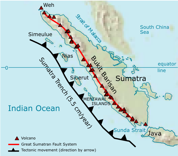
, and is adjacent to the Banda Arc. The Sunda Arc is formed via the subduction of the Indo-Australian Plate beneath the Sunda and Burma plates at a velocity of 63–70 mm/year.
Formation and geologic setting
Mid-oceanic ridge basalts (MORB) form most of the oceanic basin south of Sunda, according to geodynamic studies. These plates began to converge in the EarlyMiocene
The Miocene ( ) is the first epoch (geology), geological epoch of the Neogene Period and extends from about (Ma). The Miocene was named by Scottish geologist Charles Lyell; the name comes from the Greek words (', "less") and (', "new") and mea ...
. The Indo-Australian Plate is subducting beneath the Eurasian Plate with a dip angle of 49–56 degrees. The slab subducting under Java is continuous down to the lower mantle. However, the slab appears to beak apart under Sumatra Island''.'' Earthquake depth records indicate that there is no deep seismic activity in Sumatra
Sumatra () is one of the Sunda Islands of western Indonesia. It is the largest island that is fully within Indonesian territory, as well as the list of islands by area, sixth-largest island in the world at 482,286.55 km2 (182,812 mi. ...
, likely due to the age of the subducting complex''.'' Two types of subductions have been identified along the Sunda Arc: 1) orthogonal subduction along Java and 2) oblique subduction on the Sumatra side. These subductions are separated by the Sunda Strait
The Sunda Strait () is the strait between the Indonesian islands of Java island, Java and Sumatra. It connects the Java Sea with the Indian Ocean.
Etymology
The strait takes its name from the Sunda Kingdom, which ruled the western portion of Ja ...
.
Notable seismic events
With the ongoing magmatic activities and the nature of the subduction zone, Sunda Arc has experienced major seismic events throughout history. These events cost the loss of lives and vast destruction along the coast. These are some major seismic events that have been recorded.
Tsunami in December 2004, Indian Ocean
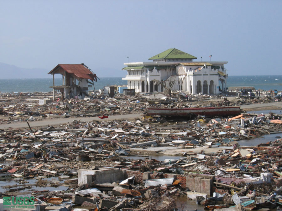
In 2004, a tsunami in the Indian Ocean was triggered by an earthquake of 9.15 magnitude near Sumatra Island. In the Banda Aceh area, thetsunami
A tsunami ( ; from , ) is a series of waves in a water body caused by the displacement of a large volume of water, generally in an ocean or a large lake. Earthquakes, volcanic eruptions and underwater explosions (including detonations, ...
height reached up to 35 meters, which surpassed the value recorded before this event.
Tsunami in July 2006, West Java and Central Java, Indonesia
An earthquake and tsunami occurred on July 17, 2006, causing major destruction in West Java and Central Java. The Mw-7.7 earthquake-induced tsunami struck over 250 km of the coastline and caused more than 600 deaths. The approximate run-up height was about 4–6 meters.Historic eruptions and arc volcanism
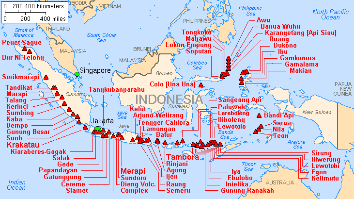
The Sunda Arc is home to some of the world's most dangerous and explosive volcanoes. The 1815 eruption of Mount Tambora onSumbawa
Sumbawa, is an Indonesian island, located in the middle of the Lesser Sunda Islands chain, with Lombok to the west, Flores to the east, and Sumba further to the southeast. Along with Lombok, it forms the province of West Nusa Tenggara, but th ...
and the 1257 eruption of Mount Samalas on Lombok
Lombok, is an island in West Nusa Tenggara province, Indonesia. It forms part of the chain of the Lesser Sunda Islands, with the Lombok Strait separating it from Bali to the west and the Alas Strait between it and Sumbawa to the east. It is rou ...
were among the largest in the last two millennia, ranking 7 on the VEI scale. The Sunda Arc subduction zone was also the site of one of the largest known eruptions of the Cenozoic
The Cenozoic Era ( ; ) is Earth's current geological era, representing the last 66million years of Earth's history. It is characterized by the dominance of mammals, insects, birds and angiosperms (flowering plants). It is the latest of three g ...
, the VEI 8 Toba supereruption on Sumatra
Sumatra () is one of the Sunda Islands of western Indonesia. It is the largest island that is fully within Indonesian territory, as well as the list of islands by area, sixth-largest island in the world at 482,286.55 km2 (182,812 mi. ...
, which expelled 2,800 km3 of magma c. 74,000 BP. The resulting caldera has become Lake Toba
Lake Toba (, Toba Batak: ᯖᯀᯬ ᯖᯬᯅ; romanized: ''Tao Toba'') is a large natural lake in North Sumatra, Indonesia, occupying the caldera of the Toba supervolcano. The lake is located in the middle of the northern part of the island of ...
. The loudest noise in recorded history
Recorded history or written history describes the historical events that have been recorded in a written form or other documented communication which are subsequently evaluated by historians using the historical method. For broader world h ...
occurred during the 1883 eruption of Krakatoa
Beginning on 20 May 1883, and ending on 21 October 1883, the volcanic island of Krakatoa, located in the Sunda Strait, had repeated, months long Types of volcanic eruptions, volcanic eruptions. The most destructive of these eruptions occurred o ...
and was heard away. Hundreds of thousands of people have been killed by these eruptions and by episodes of activity at other volcanoes, including Papandayan, Galunggung, Merapi, Kelud, Sinabung, and Agung
The agung is a set of two wide-rimmed, vertically suspended gongs used by the Maguindanao, Maranao, Sama-Bajau and Tausug people of the Philippines as a supportive instrument in kulintang ensembles. The agung is also ubiquitous among ot ...
.
Main-arc volcanism
 The main-arc volcanism along Sunda is mainly derived from the interaction between the Indo-Australian Plate and the Eurasia Plate. Magma originates from the partial melting of the mantle wedge driven by the fluids from the subducting slab. In addition, volcanic rocks from the Quaternary generally show more enrichment in alkaline contents than those from the Tertiary age. The majority of basalts of the arc have
 calc-alkaline
The calc-alkaline magma series is one of two main subdivisions of the subalkaline magma series, the other subalkaline magma series being the tholeiitic series. A magma series is a series of compositions that describes the evolution of a mafic ...
contents, except for some potassic lava production in East Java.
Back-arc volcanism
The magmatic activities along the back-arc may or may not relate to the main arc materials. Magma and lava appear to have originated from molten materials at a deeper part of the mantle as supported by a higher K2O/Na2O ratio in comparison to other parts of Sunda Arc. The most salient volcanoes in the back-arc region are Lasem, Muria, andBawean
Bawean () is an List of islands of Indonesia, island of Indonesia located approximately north of Surabaya in the Java Sea, off the coast of Java. It is administered by Gresik Regency of East Java province. It is approximately in diameter and ...
in which their volcanic rocks show complex patterns in terms of chemical signature.
Major islands
Java
Java Island is located on the east side of the Sunda Arc, located between Sumatra and Bali. Its oceanic crust's thickness is approximately 20–25 kilometers. With the geological activities and the tectonic nature of Sunda Arc, megathrust earthquakes and volcanic activities are ubiquitous on Java island. Modern volcanoes at Java are formed during the Tertiary with typical products ofandesitic
Andesite () is a volcanic rock of intermediate composition. In a general sense, it is the intermediate type between silica-poor basalt and silica-rich rhyolite. It is fine-grained (aphanitic) to porphyritic in texture, and is composed predomina ...
composition and progressively get more alkali content during the Quaternary. Along the Java island, there are approximately 62 geothermal fields that can be utilized for further usages including producing electricity. Java is also a germinal center for supplying gold and copper in which the occurrences of these low-sulfidation (LS) epithermal deposits may associate with magmatic arc activities with the spatial relationship between the akaditic magma and porphyry Cu-Au deposits.
East Java
Most volcanic activity in East Java isPlinian
Plinian eruptions or Vesuvian eruptions are volcanic eruptions characterized by their similarity to the eruption of Mount Vesuvius in 79 AD, which destroyed the ancient Roman cities of Herculaneum and Pompeii. The eruption was described in a le ...
-type, which is very explosive and emits columns of hot volcanic debris. The adiakitic magma, which deviates from usual island-arc magma, is associated with porphyry deposits. There is evidence that the Ringgit-Beser volcanic complex also produces potassic and magnesian lava, which could be a result of the decreasing influence of subduction-related material. A major volcano in East Java is Mount Bromo
The Bromo (), or Mount Bromo (, ) is an active somma volcano, a Hindu pilgrimage site, and part of the Tengger mountains, in East Java, Indonesia. At it is not the highest peak of the massif, but is the most active and famous. The area ...
.

Central Java
There exist two main arcs at Central Java which are Southern Mountain Arc (SMA) and Modern Volcanic Arc (MVA) which give rise to frequent volcanic activities. Prior studies suggested that SMA was formed during the Middle Eocene, followed by the subduction that resulted in the formation of MVA in the Late Eocene. Central Java is home to one of the most notorious volcanoes, Merapi, as well as other major volcanoes such as Merbabu, Muria, and Slamet.Mount Merapi
Mount Merapi (, ) is an active stratovolcano located on the border between the province of Central Java and the Special Region of Yogyakarta, Indonesia. It is the most active volcano in Indonesia and has erupted regularly since 1548. It is loc ...
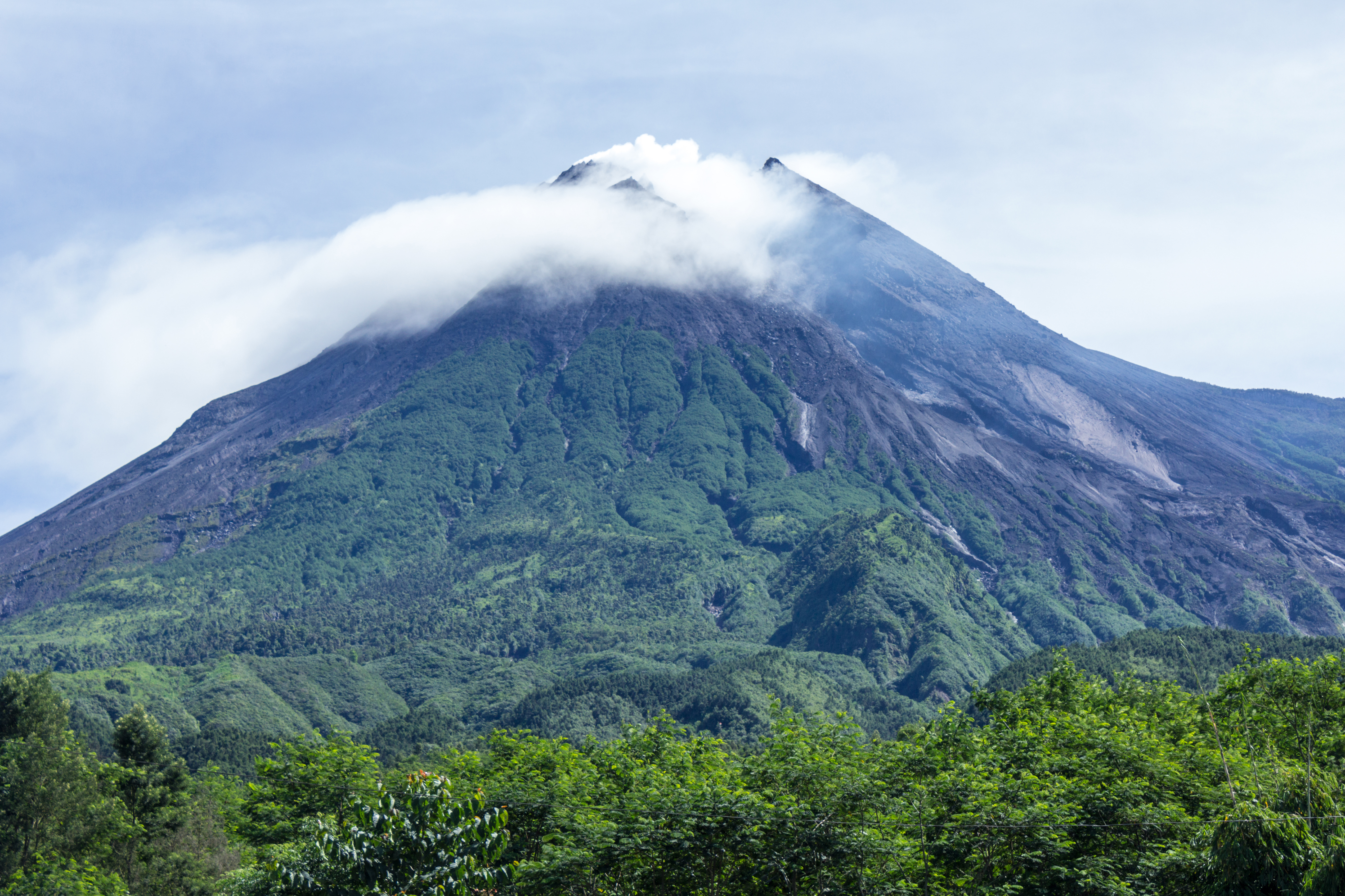
is the most active volcano in Indonesia which erupts periodically every 2–6 years and has shown perennial volcanic activities dating back roughly 2000 years ago based on carbon isotopic signatures. The earliest eruption has been approximated to be roughly 40,000 years ago. The most recent significant eruptions occurred in 1994, 2006, and 2010. Mount Merapi is a steep stratovolcano situated on Central Java Island with seismic and volcanic activities that could pose major threats to countless lives and infrastructures in its vicinity. Most recent volcanic activities are induced by the collapse of the lava dome, contributing to the highly explosive eruption of andesitic materials.
West Java
The volcanic activities in this region have begun roughly since the Late Cretaceous orPleistocene epoch
The Pleistocene ( ; referred to colloquially as the ''ice age, Ice Age'') is the geological epoch (geology), epoch that lasted from to 11,700 years ago, spanning the Earth's most recent period of repeated glaciations. Before a change was fin ...
. There are two major volcanic zones called the volcanic front (VF) and the rear arc (RA) with different chemical imprints. The volcanic development of the northern area of West Java started earlier during the Late Cretaceous period, while the southern area's volcanic development developed later during the Miocene
The Miocene ( ) is the first epoch (geology), geological epoch of the Neogene Period and extends from about (Ma). The Miocene was named by Scottish geologist Charles Lyell; the name comes from the Greek words (', "less") and (', "new") and mea ...
. The geochemical study of major and trace elements and isotopic signatures of lava have confirmed the steady-state subduction and ongoing replenishment of magma for about 10 Ma. The volcanic rocks found on West Java are dated back to the Eocene
The Eocene ( ) is a geological epoch (geology), epoch that lasted from about 56 to 33.9 million years ago (Ma). It is the second epoch of the Paleogene Period (geology), Period in the modern Cenozoic Era (geology), Era. The name ''Eocene'' comes ...
. The basement of West Java is a continental lithosphere which can be inferred from crustal assimilation and contamination in volcanic rocks. The latest large eruption recorded in the province was the 1982 eruption of Mount Galunggung, with a recorded VEI of 4.
Krakatoa
The island ofAnak Krakatau
Anak KrakatauEnglish translation and common name: ''Child of Krakatoa'' is a volcanic island in Indonesia. On 29 December 1927, Anak Krakatau first emerged from the caldera formed in 1883 by the explosive volcanic eruption that destroyed the ...
has grown at an average rate of five inches (13 cm) per week since the 1950s. Quiet periods of a few days have alternated with almost continuous Strombolian eruptions since 1994. In 1883 CE, tsunamis were triggered by the eruption of Krakatoa with a run-up of 41 meters. The magnitude of damage reached Panama, which was located almost 19,300 km away from the focus.

Sumatra
Sumatra Island is located on the southwest side of the Sunda Arc. The main seismic zone of Sumatra is the Sumatra Fault System (SFS), which trends NW-SE. The subducting oceanic crust is dated to be approximately 50 to 90 Ma. A K/Ar study reveals that subducted-related magmatism in Sumatra started roughly in the earlyMesozoic
The Mesozoic Era is the Era (geology), era of Earth's Geologic time scale, geological history, lasting from about , comprising the Triassic, Jurassic and Cretaceous Period (geology), Periods. It is characterized by the dominance of archosaurian r ...
according to the evidence derived from the plutonic body on Barisan Mountain. The key mineralization found in Sumatra is epithermal veins of Au, Ag, Zn, Pb, and other metals in which these ore bodies are correlated to arc volcanism and subvolcanism intrusive bodies.
Mount Sinabung is a stratovolcano of andesite and dacite in the Karo plateau of North Sumatra, 40 kilometres (25 mi) from the Lake Toba supervolcano. It has been continuously active since 2013.
Nusa Tenggara
Nusa Tenggara
The Lesser Sunda Islands (, , ), now known as Nusa Tenggara Islands (, or "Southeast Islands"), are an archipelago in the Indonesian archipelago. Most of the Lesser Sunda Islands are located within the Wallacea region, except for the Bali pr ...
lies on the east side of the Sunda Arc. The information and study on this island are scarce compared to Java due to the difficulty of access. Generally, the island is composed of Quaternary volcanic deposits. Major volcanoes in Nusa Tenggara are Kelimutu and Mount Rinjani
Mount Rinjani ( Sasak: ''Gunong Rinjani'', ) is an active volcano in Indonesia on the island of Lombok. Administratively the mountain is in the Regency of North Lombok, West Nusa Tenggara ( Indonesian: ''Nusa Tenggara Barat'', NTB). It rises t ...
. Another active major volcano in the region is Mount Tambora, whose eruption in 1815 led to global climate abnormalities in the subsequent year, known as the Year Without a Summer
The year 1816 is known as the Year Without a Summer because of severe climate abnormalities that caused average global temperatures to decrease by . Summer temperatures in Europe were the coldest of any on record between 1766 and 2000, resultin ...
. Seismic studies have shown clusters of seismic events beneath active island-arc volcanoes, which may be a result of the collision zone.
See also
*List of volcanoes in Indonesia
The geography of Indonesia is dominated by volcanoes that are formed due to subduction zones between the Eurasian plate and the Australian plate, Indo-Australian plate. Some of the volcanoes are notable for their eruptions, for instance, Krak ...
References
{{ReflistFurther reading
* Newcomb KR & McCann WR. (1987). ''Seismic history and seismotectonics of the Sunda Arc''. Journal of Geophysical Research; 92:421–439. Arcs of Indonesia Volcanic arcs *x *x Geology of Indonesia Plate tectonics