South Quincy (Quincy, Massachusetts) on:
[Wikipedia]
[Google]
[Amazon]
 South Quincy is a neighborhood of
Geographic Names Information Service:613005 South Quincy
 South Quincy is a neighborhood of
 Quincy, Massachusetts
Quincy ( ) is a city in Norfolk County, Massachusetts, Norfolk County, Massachusetts, United States. It is the largest city in the county. Quincy is part of the Greater Boston area as one of Boston's immediate southern suburbs. Its population in ...
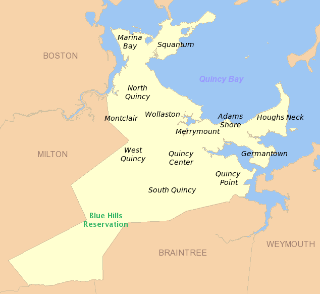
. Located in the south central portion of the city, South Quincy is bordered on the north by Quincy Center and West Quincy, on the east by Quincy Avenue and the Quincy Point
Quincy Point is a neighborhood of Quincy, Massachusetts. "The Point" is generally defined as the land east of Quincy Center, the downtown district. Quincy Point is bordered on the west by Elm Street, on the east by Weymouth Fore River and the B ...
neighborhood, on the south by Braintree and on the west by Interstate 93
Interstate 93 (I-93) is an Interstate Highway in the New England states of Massachusetts, New Hampshire, and Vermont in the United States. Spanning approximately along a north–south axis, it is one of three primary Interstate Highways ...
.
History
South Quincy became populated in part as a result of the growth of thegranite
Granite ( ) is a coarse-grained (phanerite, phaneritic) intrusive rock, intrusive igneous rock composed mostly of quartz, alkali feldspar, and plagioclase. It forms from magma with a high content of silica and alkali metal oxides that slowly coo ...
industry in Quincy in the 1800s. Part of the neighborhood was once farms owned by Charles Francis Adams, Sr. and Job Faxon that were subdivided into lots. The Faxon family donated land to the city in 1885 that became the wooded Faxon Park. In 1987, the neighborhood became home to the Crown Colony Office Park, located at the Braintree Split
The Braintree Split is the major interchange of Interstate 93 (I-93), U.S. Route 1 (US 1), and Route 3 in Braintree, Massachusetts, one of the South Shore suburbs of Boston. Traveling northbound, the routes merge into a three-way concurren ...
intersection of Interstate 93
Interstate 93 (I-93) is an Interstate Highway in the New England states of Massachusetts, New Hampshire, and Vermont in the United States. Spanning approximately along a north–south axis, it is one of three primary Interstate Highways ...
and Massachusetts Route 3
Route 3 is a state-numbered route in the U.S. state of Massachusetts, maintained by the Massachusetts Department of Transportation (MassDOT). Spanning approximately along a north–south axis, it is inventoried with U.S. Route 3 (US 3) a ...
on the site of the former Old Colony Crushed Stone Company.
Transportation
Burgin Parkway, Centre Street, Independence Avenue and Water Street are major thoroughfares in the neighborhood. South Quincy is served by bus routes 230, 236, and 238 of theMassachusetts Bay Transportation Authority
The Massachusetts Bay Transportation Authority (abbreviated MBTA and known colloquially as "the T") is the public agency responsible for operating most public transportation services in Greater Boston, Massachusetts. The MBTA transit network in ...
. South Quincy is also the location of the Quincy Adams subway station and parking facility, a major transportation hub for South Shore Massachusetts commuters. The Southeast Expressway is located adjacent to the neighborhood on the west.
External links
* United States Geological SurveGeographic Names Information Service:613005 South Quincy
Notes
Neighborhoods in Massachusetts Populated places in Norfolk County, Massachusetts Quincy, Massachusetts {{NorfolkCountyMA-geo-stub