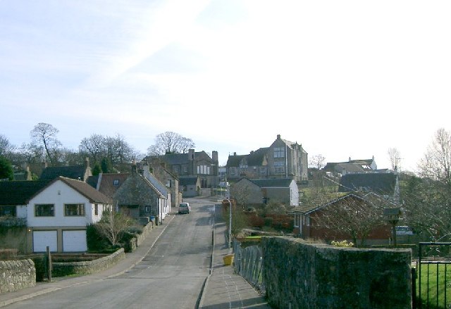
Saline, Fife on:
[Wikipedia]
[Google]
[Amazon]
Saline is a village and parish in 
Gazetteer for Scotland entry
About Saline
a
Fife Council
{{authority control Villages in Fife Parishes in Fife
Fife
Fife ( , ; ; ) is a council areas of Scotland, council area and lieutenancy areas of Scotland, lieutenancy area in Scotland. A peninsula, it is bordered by the Firth of Tay to the north, the North Sea to the east, the Firth of Forth to the s ...
, Scotland, situated to the north-west of Dunfermline
Dunfermline (; , ) is a city, parish, and former royal burgh in Fife, Scotland, from the northern shore of the Firth of Forth. Dunfermline was the de facto capital of the Kingdom of Scotland between the 11th and 15th centuries.
The earliest ...
. It lies in an elevated position on the western slopes of the Cleish Hills
Cleish is a rural hamlet off the B9097 between Crook of Devon and the M90 motorway, three miles south-west of Kinross in central Scotland. It lies in the historic county of Kinross-shire.
At the last census (2011), the population of the civil ...
.
At the 2001 census the population was 1188, a decline from the 1235 recorded in the 1991 census
It was the final year of the Cold War, which had begun in 1947. During the year, the Soviet Union collapsed, leaving fifteen sovereign republics and the CIS in its place. In July 1991, India abandoned its policies of dirigism, license r ...
. The village has a primary school, a parish church and a golf course. The glen runs from the bottom of the main street through to neighbouring Steelend
Steelend is a former mining village in West Fife, Scotland, located on the B914 road approximately three-quarters of a mile east of the village of Saline and four miles north-west of Dunfermline. The village is home to a community centre and th ...
.
The civil parish has a population of 1,762 (in 2011)Census of Scotland 2011, Table KS101SC – Usually Resident Population, publ. by National Records of Scotland. Web site http://www.scotlandscensus.gov.uk/ retrieved March 2016. See “Standard Outputs”, Table KS101SC, Area type: Civil Parish 1930 and an area of 8,757 acres.Gazetteer of Scotland, publ, by W & AK Johnston, Edinburgh, 1937. Article on Saline. Places are presented alphabetically
The village is dominated to the east-north-east by Saline Hill, 359 meters OD, with a hill fort
A hillfort is a type of fortification, fortified refuge or defended settlement located to exploit a rise in elevation for defensive advantage. They are typical of the late Bronze Age Europe, European Bronze Age and Iron Age Europe, Iron Age. So ...
on the eastern summit. The smaller hill to the south of east at Bandrum has a standing stone
A menhir (; from Brittonic languages: ''maen'' or ''men'', "stone" and ''hir'' or ''hîr'', "long"), standing stone, orthostat, or lith is a large upright rock (geology), stone, emplaced in the ground by humans, typically dating from the Eur ...
on the peak.

History
A pre-Reformation
The Reformation, also known as the Protestant Reformation or the European Reformation, was a time of major Theology, theological movement in Western Christianity in 16th-century Europe that posed a religious and political challenge to the p ...
church was under control of Dunkeld Cathedral
Dunkeld Cathedral is a Church of Scotland place of worship which stands on the north bank of the River Tay in Dunkeld, Perth and Kinross, Scotland. Built in square-stone style of predominantly grey sandstone, the cathedral proper began in 1260 a ...
.
Formerly a weaving centre, Saline was not much redeveloped during the 19th and 20th centuries as the expansion of industrial mining in west Fife largely passed it by. As a result, Saline contains a sizable number of listed building
In the United Kingdom, a listed building is a structure of particular architectural or historic interest deserving of special protection. Such buildings are placed on one of the four statutory lists maintained by Historic England in England, Hi ...
s, mostly 18th century weavers' cottages.
The parish church was designed by William Stark in 1808 and remodelled in 1905 by Glasgow
Glasgow is the Cities of Scotland, most populous city in Scotland, located on the banks of the River Clyde in Strathclyde, west central Scotland. It is the List of cities in the United Kingdom, third-most-populous city in the United Kingdom ...
architect Peter MacGregor Chalmers
Peter MacGregor Chalmers LLD (14 March 1859 – 15 March 1922) was a Scottish architect specialising in country churches, and also being involved in several important restoration schemes.
Life
Chalmers was born on 14 March 1859, the son of Georg ...
. Following the Disruption of 1843
The Disruption of 1843, also known as the Great Disruption, was a schism in 1843 in which 450 evangelical ministers broke away from the Church of Scotland to form the Free Church of Scotland.
The main conflict was over whether the Church of Sc ...
a Free Church was built on Bridge Street by Lewis Mercer
Lewis may refer to:
Names
* Lewis (given name), including a list of people with the given name
* Lewis (surname), including a list of people with the surname
Music
* Lewis (musician), Canadian singer
* " Lewis (Mistreated)", a song by Radiohea ...
.
Famous residents
Thomas Bonnar (1821–1862), an architect, was born here. John Barrowman (-1860), inventor of the Barrowman plough lived here.References
External links
Gazetteer for Scotland entry
About Saline
a
Fife Council
{{authority control Villages in Fife Parishes in Fife