Nayagaon, Bihar on:
[Wikipedia]
[Google]
[Amazon]
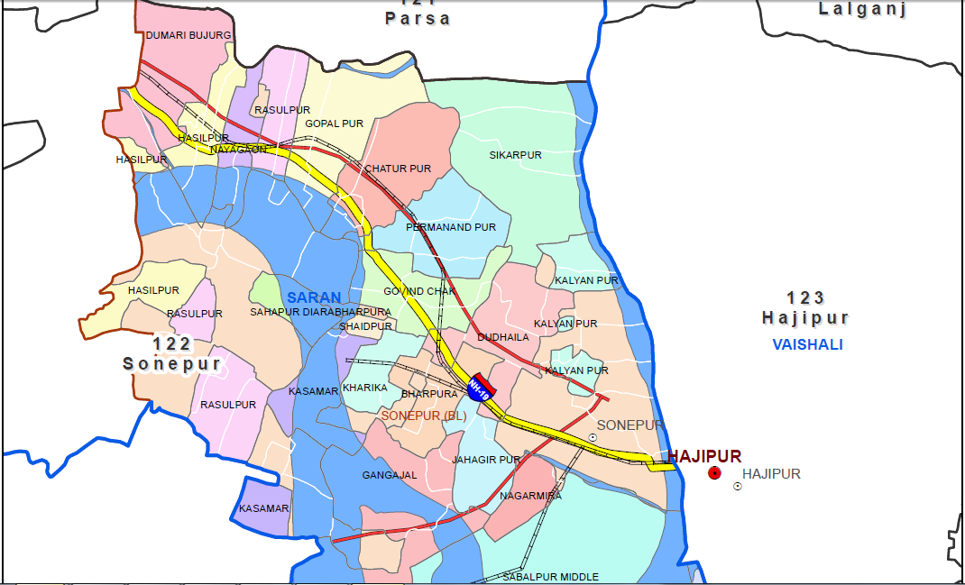
Nayagaon is a semi-urban area in Sonpur Block in Saran in
path
https://www.google.com/maps/@25.7597006,85.0973177,1156m/data=!3m1!1e3?hl=en Google location]
 Nayagaon has a good market.
* State Bank of India, Nayagaon Branch (004862), Saran, Bihar – IFSC Code-SBIN0004862
* Gogal Singh Intermediate College , Nayagaon
*
 Panchayat Elections in Sonepur were held in June 2016.
 Areas that come under the jurisdiction of Nayagaon P.S are:
# Mohammadchak
# Rasulpur
# Kasturi Chak-Paswan tola
# Chuturpur
# Madrani Chak ghat
# Nayagaon
# Sitabganj
# Dumri Buzurg
Bihar
Bihar ( ) is a states and union territories of India, state in Eastern India. It is the list of states and union territories of India by population, second largest state by population, the List of states and union territories of India by are ...
, India. Nayagaon is part of Sonpur (Vidhan Sabha constituency)
Sonpur Assembly constituency, often spelt Sonepur, is in Saran district in the Indian state of Bihar.
Ram Sundar Das, sitting MLA from Sonpur 1977–1980, served as Bihar's Chief Minister briefly in 1979.
Overview
As per Delimitation of Par ...
and Saran (Lok Sabha constituency)
Saran is one of the 40 Lok Sabha (parliamentary) constituencies in Bihar state in eastern India. This constituency came into existence in 2008 as a part of the implementation of delimitation of parliamentary constituencies based on the recommend ...
. New townships are being built in Nayagaon, N G Town by Phenomenal Projects Pvt., The Sai Green Mega Township Project by TCW (The Corporate World) Realty under Greater Patna Project, Natural City by Bold India Infra Private Limited Devkripa Green city Shital Green City Project Of Shital Buildtech Pvt Ltd, Kazari infra tech pvt ltd, Rav Residency and Aryavart Group. The distance of Nayagaon to Patna(Patliputra
Pataliputra (IAST: ), adjacent to modern-day Patna, Bihar, was a city in ancient India, originally built by Magadha ruler Ajatashatru in 490 BCE, as a small fort () near the Ganges river.. Udayin laid the foundation of the city of Pataliput ...
) has been reduced from earlier 45 km to 15 km due to Digha–Sonpur rail–road bridge. Nayagaon is located on NH 19
National Highway 19 (NH 19) is a national highway in India. It was previously referred to as Delhi–Kolkata Road and is one of the busiest national highways in India. After renumbering of national highways, Delhi to Agra route is now nationa ...
, Nayagaon Sarai. Nayagaon is located at Mouza
In Bangladesh, Pakistan and parts of India, a mouza or mauza (also mouja) is a type of administrative district, corresponding to a specific land area within which there may be one or more settlements. Before the 20th century, the term referred to a ...
/Mauja
Mauja () is a town and Village development committee in Kaski District in the Gandaki Zone of northern-central Nepal. Most of the people lived in villages. A village was also called "Mauja". The chief of the village was the Patil. He used to try ...
Rasulpur. It is located along river Ganges
The Ganges ( ; in India: Ganga, ; in Bangladesh: Padma, ). "The Ganges Basin, known in India as the Ganga and in Bangladesh as the Padma, is an international which goes through India, Bangladesh, Nepal and China." is a trans-boundary rive ...
. It is also near the under construction Hajipur-Chhapra-Ghazipur four-lane Highway ( NH 31). The distance to AIIMS Patna
All India Institute of Medical Sciences Patna (AIIMS Patna), previously Jaya Prakash Narayan All India Institute of Medical Sciences (JPNAIIMS), is a medical college and medical research public institute located in Phulwari Sharif, Patna, Bi ...
in Phulwari Sharif
Phulwari or Phulwari Sharif is Block and town in Patna district in the Indian state of Bihar. It is included in the Patna Metropolitan Region and is one of the fastest growing area of urban Patna. The civilisation of the city dates back to t ...
is also reduced due to Digha-AIIMS elevated highway (Patli Path
Patli Path (also known as AIIMS-Digha elevated corridor) is an elevated road in Patna, the capital of Bihar. It was inaugurated by Chief Minister Nitish Kumar on 30 November 2020. At the time of inauguration of this elevated road, it was the longe ...
). Census code of Nayagaon is 234491. A power sub-station became functional in Nayagaon under Deen Dayal Upadhyaya Gram Jyoti Yojana
Deen Dayal Upadhyaya Gram Jyoti Yojana is a Government of India scheme designed to provide continuous electricity supply to rural India. The government plans to invest for rural electrification under this scheme. The scheme replaced the existin ...
in August 2020. An ITI ( Industrial training institute) is also planned in Nayagaon. Nayagaon is 12 km from Rail Wheel Plant, Bela, Dariapur Block in Saran. A stadium is being constructed at the cost of Rs 55 lakhs in the sports ground of Gogal Singh Intermediate College, Nayagaon. An inter-modal terminal at Kalughat, Nayagaon is being constructed as part of National Waterway 1
The National Waterway 1 (NW-1) or Ganga-Bhagirathi-Hooghly river system is located in India and runs from Prayagraj in Uttar Pradesh to Haldia in West Bengal via Patna and Bhagalpur in Bihar across the Ganges river. It is long, making it the l ...
under the government's Jal Marg Vikas project.
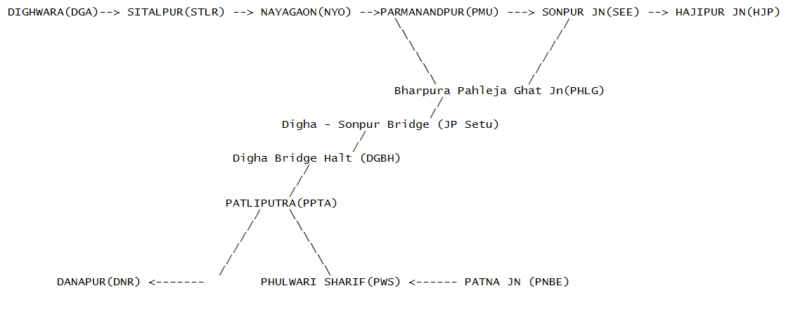
Naya gaon railway station
Nayagaon falls under the jurisdiction ofSonpur railway division
Sonpur railway division is one of the five railway divisions under the jurisdiction of East Central Railway zone of the Indian Railways.
History
Sonpur division was established on 21 Oct. 1978 in North Eastern Railway zone. The ECR zone cam ...
. Route between Nayagaon and Digha Bridge Haltpath
https://www.google.com/maps/@25.7597006,85.0973177,1156m/data=!3m1!1e3?hl=en Google location]

Important landmarks
 Nayagaon has a good market.
* State Bank of India, Nayagaon Branch (004862), Saran, Bihar – IFSC Code-SBIN0004862
* Gogal Singh Intermediate College , Nayagaon
*
 Kasturba Gandhi Balika Vidyalaya
The Kasturba Gandhi Balika Vidyalaya or KGBV is a residential girls’ secondary school run by the Government of India for the weaker sections in India.
History
The plan was introduced by the Government of India in August 2004. It was then integr ...
(KGBV), Nayagaon
* Sant Ravidas Bhavan
* Kaalratri
Kalaratri () is the seventh of the nine Navadurga forms of the goddess Mahadevi. She is first referenced in the Devi Mahatmya. Kalaratri is one of the fearsome forms of the goddess.
It is not uncommon to find the names ''Kali'' and ''Kalaratri' ...
Temple, Dumri Buzurg, Nayagaon.
* St. Kevin's Academy, Nayagaon
* Raghubir Singh High School, Mahadalichak, Nayagaon
* Devki Nand senior secondary school Nayagaon
* Upgraded Middle School (Ums) Baherwa Gachi School, Nayagaon.
* SAHID RAJENDRA DWAR
Demographics
The population of Nayagaon is 8,575 as per 2011 census. The sex ratio is 924 females per 1000 males. Area of Nayagaon is 209 hectares.Nayagaon Panchayat
 Panchayat Elections in Sonepur were held in June 2016.
Nayagaon Police Station
 Areas that come under the jurisdiction of Nayagaon P.S are:
# Mohammadchak
# Rasulpur
# Kasturi Chak-Paswan tola
# Chuturpur
# Madrani Chak ghat
# Nayagaon
# Sitabganj
# Dumri Buzurg
References
{{Sonpur Block, Bihar Villages in Saran district