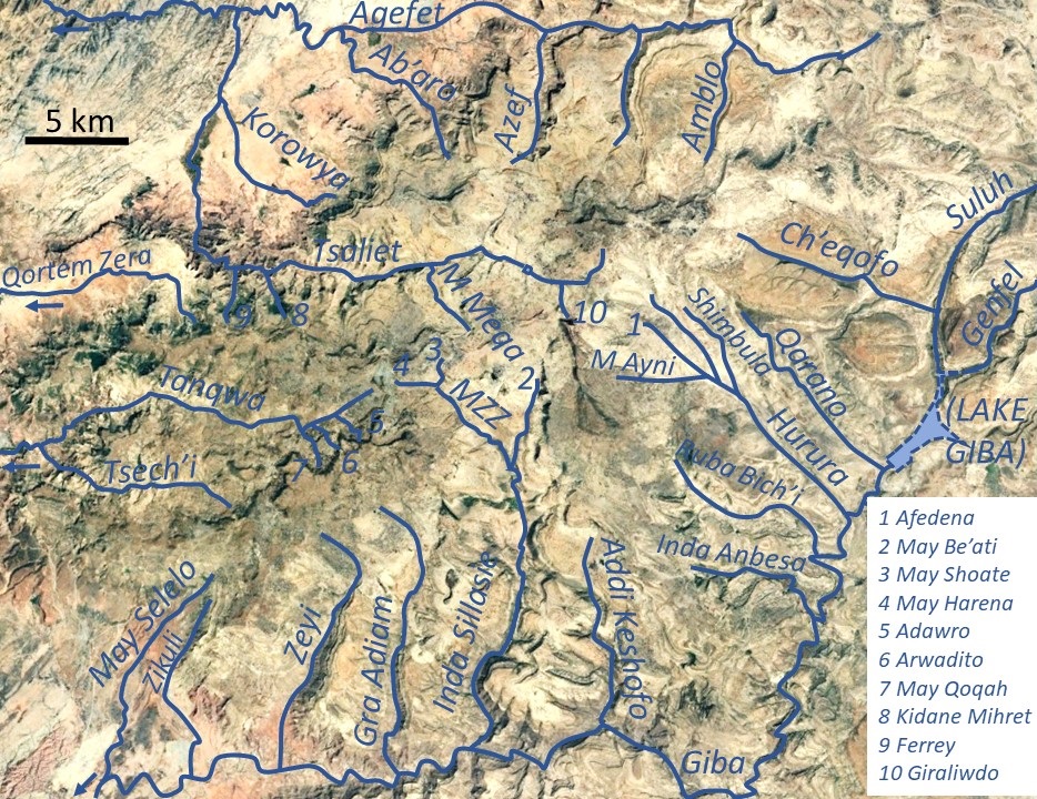
May Qoqah on:
[Wikipedia]
[Google]
[Amazon]
The May Qoqah is a river of the 

Public GPS traces tagged with nyssen-jacob-frankl , OpenStreetMap
/ref> Trek 7 partly follows the river and allows visiting the log dams.
Nile
The Nile (also known as the Nile River or River Nile) is a major north-flowing river in northeastern Africa. It flows into the Mediterranean Sea. The Nile is the longest river in Africa. It has historically been considered the List of river sy ...
basin. Rising on the Ts’ats’en plateau of Dogu’a Tembien in northern Ethiopia
Ethiopia, officially the Federal Democratic Republic of Ethiopia, is a landlocked country located in the Horn of Africa region of East Africa. It shares borders with Eritrea to the north, Djibouti to the northeast, Somalia to the east, Ken ...
, it flows northward to empty finally in the Giba
Gilberto Amauri de Godoy Filho (), known as Giba (; born 23 December 1976), is a Brazilian former professional volleyball player who played as an outside hitter. For much of the 2000s, he was widely regarded as one of the best volleyball playe ...
and Tekezé River
The Tekezé River (; , originally meaning "river" in Ge’ez; , also spelled Takkaze; ), is a major river in Ethiopia. For part of its course it forms a section of the westernmost border of Ethiopia and Eritrea. The river is also known as the Seti ...
.

Characteristics
It is a confined bedrock river, with an average slope gradient of 90 metres per kilometre. The river has cut a gorge in the surrounding basalt.Flash floods and flood buffering
Runoff mostly happens in the form of high runoff discharge events that occur in a very short period (called flash floods). These are related to the steep topography, often little vegetation cover and intense convective rainfall. The peaks of such flash floods have often a 50 to 100 times larger discharge than the precedingbaseflow
Baseflow (also called drought flow, groundwater recession flow, low flow, low-water flow, low-water discharge and sustained or fair-weather runoff) is the portion of the streamflow that is sustained between precipitation events, fed to streams by d ...
.
The magnitude of floods in this river has however been decreased due to interventions in the catchment. Physical conservation structures such as stone bunds and check dams also intercept runoff.
Observing that, in rivers with coarse bedload
The term bed load or bedload describes particles in a flowing fluid (usually water) that are transported along the stream bed. Bed load is complementary to suspended load and wash load.
Bed load moves by rolling, sliding, and/or saltating (hop ...
, gabion
A gabion (from Italian ''gabbione'' meaning "big cage"; from Italian ''gabbia'' and Latin ''cavea'' meaning "cage") is a cage, cylinder or box filled with rocks, concrete, or sometimes sand and soil for use in civil engineering, road building ...
check dams were destroyed by abrasion, boulder-faced log dams were installed transversally across this torrent. They were embedded in the banks of torrent, 0.5–1 m above the bed, and their upstream sides were faced with large rocks. Such dams lead to temporary water ponding, spreading of peak flow over the entire channel width, and sediment deposition. After testing under extreme flow conditions (including two heavy storms) it appeared that 60% of the dams resisted strong floods, particularly in the upper segment of the river. Neighbouring farmers appreciate such structures to control first-order torrents with coarse bed load because the technique is cheap and can be easily installed.

Irrigated agriculture in Hamute
Besides springs and reservoirs,irrigation
Irrigation (also referred to as watering of plants) is the practice of applying controlled amounts of water to land to help grow crops, landscape plants, and lawns. Irrigation has been a key aspect of agriculture for over 5,000 years and has bee ...
is strongly dependent on the river's baseflow
Baseflow (also called drought flow, groundwater recession flow, low flow, low-water flow, low-water discharge and sustained or fair-weather runoff) is the portion of the streamflow that is sustained between precipitation events, fed to streams by d ...
. Such irrigated agriculture is important in meeting the demands for food security and poverty reduction. Irrigated lands are established at the outlet of the gorge in Hamute.
Boulders and pebbles in the river bed
Boulders and pebbles encountered in the river bed can originate from any location higher up in the catchment. In the uppermost stretches of the river, only rock fragments of the upper lithological units will be present in the river bed, whereas more downstream one may find a more comprehensive mix of all lithologies crossed by the river. From upstream to downstream, the following lithological units occur in the catchment. * Upper basalt * Interbedded lacustrine deposits * Lower basalt * Amba Aradam FormationTrekking along the river
Trekking routes have been established across and along this river. The tracks are not marked on the ground but can be followed using downloaded .GPX files./ref> Trek 7 partly follows the river and allows visiting the log dams.
See also
* List of Ethiopian riversReferences
{{reflist Rivers of Ethiopia Dogu'a Tembien Tigray Region Nile basin