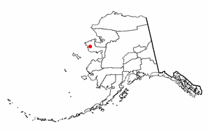
Mary's Igloo, Alaska on:
[Wikipedia]
[Google]
[Amazon]
 Mary's Igloo (''Qawiaraq'' or ''Aġviġnaq'' in Iñupiaq) is an abandoned village located in the Nome Census Area of the
Unorganized Borough
The Unorganized Borough is composed of the portions of the U.S. state of Alaska which are not contained in any of its 19 organized boroughs. While referred to as the "Unorganized Borough", it is not a borough itself, as it forgoes that level o ...
in the U.S. state
In the United States, a state is a constituent political entity, of which there are 50. Bound together in a political union, each state holds governmental jurisdiction over a separate and defined geographic territory where it shares its so ...
of Alaska
Alaska ( ) is a non-contiguous U.S. state on the northwest extremity of North America. Part of the Western United States region, it is one of the two non-contiguous U.S. states, alongside Hawaii. Alaska is also considered to be the north ...
, now used as a fish camp. Many former residents and their descendants currently live in nearby Teller or the next largest community, Nome
Nome may refer to:
Country subdivision
* Nome (Egypt), an administrative division within ancient Egypt
* Nome (Greece), the administrative division immediately below the ''peripheries of Greece'' (, pl. )
Places United States
* Nome, Alaska
...
.
History
The Inupiat village of ''Kauwerak'' was located about downriver from Mary's Igloo. By 1900, Kauwerak was abandoned and most of its residents moved to Teller or Nome because of schools and employment opportunities. A few settled at the site of Mary's Igloo, which they called ''Aukvaunlook'' (''Aġviġnaq''), meaning "black whale." During the gold prospecting period of the early 1900s, non-Natives
There is no generally accepted definition of Indigenous peoples, although in the 21st century the focus has been on self-identification, cultural difference from other groups in a state, a special relationship with their traditional territ ...
named the village "Mary's Igloo," after an Inupiaq woman named Mary, who welcomed miners, trappers and others into her home for coffee. During that period, Mary's Igloo was a transfer point for supplies for the gold fields upriver on the Kuzitrin and Kougarok rivers. The supplies were offloaded from ocean boats onto barges, which were towed to their destinations. A post office and store were opened at Mary's Igloo in 1901. By the 1910 census, Mary's Igloo was a community of 141 Inupiat and Anglo-Americans, who were miners, innkeepers, missionaries and support crews for the barges. It had schools, a post office and other services.
The flu epidemic of 1918 and 1919 and a tuberculosis epidemic, two years later, decimated the community's population. Catholic
The Catholic Church (), also known as the Roman Catholic Church, is the List of Christian denominations by number of members, largest Christian church, with 1.27 to 1.41 billion baptized Catholics Catholic Church by country, worldwid ...
and Lutheran
Lutheranism is a major branch of Protestantism that emerged under the work of Martin Luther, the 16th-century German friar and Protestant Reformers, reformer whose efforts to reform the theology and practices of the Catholic Church launched ...
orphanages opened in the area to care for children left without parents.
The schools closed in 1948 and 1950 for lack of students and the post office and store also closed in 1952. Most of the residents moved to Nome or Teller.
The site of Mary's Igloo presently has no permanent population. It is used as a seasonal fish camp by some residents of Teller.
Demographics
Mary's Igloo first appeared on the 1910 U.S. Census as "Igloo", an unincorporated village. It did not officially appear as Mary's Igloo until 1950. It did not appear again on the census until 1980, although the population was zero. It was classified as an Alaskan Native Village Statistical Area (ANVSA). It has not reported any residents since.Geography
Mary's Igloo is located at ., on the northwest bank of the Kuzitrin River, on theSeward Peninsula
The Seward Peninsula is a large peninsula on the western coast of the U.S. state of Alaska whose westernmost point is Cape Prince of Wales. The peninsula projects about into the Bering Sea between Norton Sound, the Bering Strait, the Chukchi ...
. It is northeast of Nome
Nome may refer to:
Country subdivision
* Nome (Egypt), an administrative division within ancient Egypt
* Nome (Greece), the administrative division immediately below the ''peripheries of Greece'' (, pl. )
Places United States
* Nome, Alaska
...
and 65 km (40 mi) southeast of Teller.
References
{{authority control Geography of Nome Census Area, Alaska Unincorporated communities in Alaska Ghost towns in Alaska Inupiat