Fayette County, Iowa on:
[Wikipedia]
[Google]
[Amazon]
Fayette County is a
 U.S. Highway 18
*
 Iowa Highway 56
*
 Iowa Highway 93
*
 Iowa Highway 187
*
 Iowa Highway 281

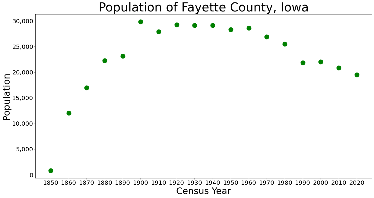
 The 2020 census recorded a population of 19,509 in the county, with a population density of . 96.09% of the population reported being of one race. There were 9,298 housing units of which 8,174 were occupied.
County website
Fayette County Economic Development
Fayette County Health and Demographic Data
{{coord, 42, 51, 54, N, 91, 50, 58, W, region:US-IA_type:adm2nd_source:dewiki, display=title 1837 establishments in Wisconsin Territory Populated places established in 1837
county
A county () is a geographic region of a country used for administrative or other purposesL. Brookes (ed.) '' Chambers Dictionary''. Edinburgh: Chambers Harrap Publishers Ltd, 2005. in some nations. The term is derived from the Old French denoti ...
located in the U.S. state of Iowa
Iowa ( ) is a U.S. state, state in the upper Midwestern United States, Midwestern region of the United States. It borders the Mississippi River to the east and the Missouri River and Big Sioux River to the west; Wisconsin to the northeast, Ill ...
. As of the 2020 census, the population was 19,509. The capital city
A capital city, or just capital, is the municipality holding primary status in a country, state (polity), state, province, department (administrative division), department, or other administrative division, subnational division, usually as its ...
is West Union.
History
Fayette County was founded on December 21, 1837, as a part ofWisconsin Territory
The Territory of Wisconsin was an organized and incorporated territory of the United States that existed from July 3, 1836, until May 29, 1848, when an eastern portion of the territory was admitted to the Union as the State of Wisconsin. Belm ...
. It was named after Gilbert du Motier, marquis de La Fayette
Marie-Joseph Paul Yves Roch Gilbert du Motier de La Fayette, Marquis de La Fayette (; 6 September 1757 – 20 May 1834), known in the United States as Lafayette (), was a French military officer and politician who volunteered to join the Conti ...
, a French general and politician, who came to America in 1777 to fight in the Revolutionary War, and who was named Major General of the Continental Army. The county was formed as part of a large reorganization of Dubuque County, which at that time comprised most of the northern half of Iowa, Minnesota, and parts of the Dakotas. Fayette County was granted the Minnesota and Dakotas territory on that date. It became part of Iowa Territory when it was formed on July 4, 1838. Fayette County's size was drastically reduced into land that was part of the modern state of Iowa in 1843, then further split in 1847 after Iowa had achieved statehood. The county was organized in 1850.
Geography
According to theU.S. Census Bureau
The United States Census Bureau, officially the Bureau of the Census, is a principal agency of the U.S. federal statistical system, responsible for producing data about the American people and economy. The U.S. Census Bureau is part of the U ...
, the county has a total area of , of which is land and (0.07%) is water.
Major highways
*Iowa Highway 3
Iowa Highway 3 (Iowa 3) is a state highway that runs from east to west across the state of Iowa. It is the longest state highway in Iowa, at long. Iowa 3 begins at the South Dakota state line where it continues as South Dakota High ...
*Iowa Highway 150
Iowa Highway 150 (Iowa 150) is an state highway (Iowa), state highway in eastern and northeastern Iowa. It begins at U.S. Route 218 (US 218) in Vinton, Iowa, Vinton and ends at U.S. Route 52 in Iowa, US 52 and Iowa Highway 24, Io ...
*Adjacent counties
* Allamakee County (northeast) * Black Hawk County (southwest) * Buchanan County (south) * Bremer County (west) * Chickasaw County (northwest) * Clayton County (east) * Delaware County (southeast) * Winneshiek County (north)Demographics

2020 census
 The 2020 census recorded a population of 19,509 in the county, with a population density of . 96.09% of the population reported being of one race. There were 9,298 housing units of which 8,174 were occupied.
2010 census
The 2010 census recorded a population of 20,880 in the county, with a population density of . There were 9,558 housing units, of which 8,634 were occupied.2000 census
As of the census of 2000, there were 22,008 people, 8,778 households, and 5,951 families residing in the county. The population density was . There were 9,505 housing units at an average density of . The racial makeup of the county was 97.71%White
White is the lightest color and is achromatic (having no chroma). It is the color of objects such as snow, chalk, and milk, and is the opposite of black. White objects fully (or almost fully) reflect and scatter all the visible wa ...
, 0.53% Black
Black is a color that results from the absence or complete absorption of visible light. It is an achromatic color, without chroma, like white and grey. It is often used symbolically or figuratively to represent darkness.Eva Heller, ''P ...
or African American
African Americans, also known as Black Americans and formerly also called Afro-Americans, are an Race and ethnicity in the United States, American racial and ethnic group that consists of Americans who have total or partial ancestry from an ...
, 0.13% Native American, 0.40% Asian, 0.03% Pacific Islander
Pacific Islanders, Pasifika, Pasefika, Pacificans, or rarely Pacificers are the peoples of the list of islands in the Pacific Ocean, Pacific Islands. As an ethnic group, ethnic/race (human categorization), racial term, it is used to describe th ...
, 0.43% from other races, and 0.77% from two or more races. 1.50% of the population were Hispanic
The term Hispanic () are people, Spanish culture, cultures, or countries related to Spain, the Spanish language, or broadly. In some contexts, Hispanic and Latino Americans, especially within the United States, "Hispanic" is used as an Ethnici ...
or Latino of any race.
There were 8,778 households, out of which 30.40% had children under the age of 18 living with them, 56.80% were married couples living together, 7.40% had a female householder with no husband present, and 32.20% were non-families. 28.20% of all households were made up of individuals, and 15.00% had someone living alone who was 65 years of age or older. The average household size was 2.41 and the average family size was 2.96.
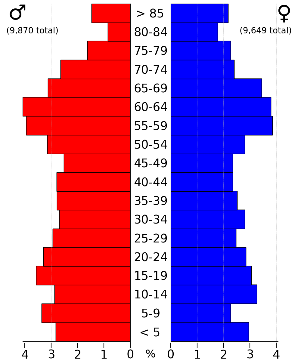
In the county, the population was spread out, with 25.00% under the age of 18, 8.60% from 18 to 24, 24.90% from 25 to 44, 22.40% from 45 to 64, and 19.00% who were 65 years of age or older. The median age was 39 years. For every 100 females there were 97.50 males. For every 100 females age 18 and over, there were 95.10 males.
The median income for a household in the county was $32,453, and the median income for a family was $39,960. Males had a median income of $27,493 versus $20,099 for females. The per capita income for the county was $17,271. About 8.20% of families and 10.80% of the population were below the poverty line, including 12.30% of those under age 18 and 12.00% of those age 65 or over.
Communities
Cities
* Arlington * Clermont * Elgin * Fayette * Fairbank * Hawkeye * Maynard *Oelwein
Oelwein is a city in Fayette County, Iowa, United States. The population was 5,920 at the time of the 2020 census, a decrease of 11.5% from the 2000 census. The largest community in Fayette County, it is located at the junction of State Highways ...
* Randalia
* St. Lucas
*Stanley
Stanley may refer to:
Arts and entertainment
Film and television
* ''Stanley'' (1972 film), an American horror film
* ''Stanley'' (1984 film), an Australian comedy
* ''Stanley'' (1999 film), an animated short
* ''Stanley'' (1956 TV series) ...
* Wadena
* Waucoma
* West Union
* Westgate
Unincorporated communities
*Alpha
Alpha (uppercase , lowercase ) is the first letter of the Greek alphabet. In the system of Greek numerals, it has a value of one. Alpha is derived from the Phoenician letter ''aleph'' , whose name comes from the West Semitic word for ' ...
* Donnan
*Oran
Oran () is a major coastal city located in the northwest of Algeria. It is considered the second most important city of Algeria, after the capital, Algiers, because of its population and commercial, industrial and cultural importance. It is w ...
* Richfield
Townships
Fayette County is divided into twenty townships: * Auburn * Banks *Bethel
Bethel (, "House of El" or "House of God",Bleeker and Widegren, 1988, p. 257. also transliterated ''Beth El'', ''Beth-El'', ''Beit El''; ; ) was an ancient Israelite city and sacred space that is frequently mentioned in the Hebrew Bible.
Bet ...
* Center
* Clermont
* Dover
Dover ( ) is a town and major ferry port in Kent, southeast England. It faces France across the Strait of Dover, the narrowest part of the English Channel at from Cap Gris Nez in France. It lies southeast of Canterbury and east of Maidstone. ...
* Eden
* Fairfield
* Fremont
* Harlan
* Illyria
In classical and late antiquity, Illyria (; , ''Illyría'' or , ''Illyrís''; , ''Illyricum'') was a region in the western part of the Balkan Peninsula inhabited by numerous tribes of people collectively known as the Illyrians.
The Ancient Gree ...
* Jefferson
* Oran
Oran () is a major coastal city located in the northwest of Algeria. It is considered the second most important city of Algeria, after the capital, Algiers, because of its population and commercial, industrial and cultural importance. It is w ...
* Pleasant Valley
* Putnam
* Scott
* Smithfield
* Union
* Westfield
* Windsor
Population ranking
The population ranking of the following table is based on the 2020 census of Fayette County. † ''county seat''Politics
See also
* National Register of Historic Places listings in Fayette County, IowaReferences
External links
County website
Fayette County Economic Development
Fayette County Health and Demographic Data
{{coord, 42, 51, 54, N, 91, 50, 58, W, region:US-IA_type:adm2nd_source:dewiki, display=title 1837 establishments in Wisconsin Territory Populated places established in 1837