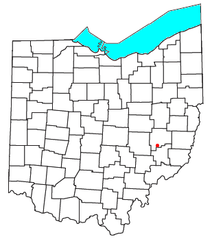
Derwent, Ohio on:
[Wikipedia]
[Google]
[Amazon]
 Derwent is an
 Derwent is an
 unincorporated community
An unincorporated area is a parcel of land that is not governed by a local general-purpose municipal corporation. (At p. 178.) They may be governed or serviced by an encompassing unit (such as a county) or another branch of the state (such as th ...
in central Valley Township, Guernsey County, Ohio
Ohio ( ) is a U.S. state, state in the Midwestern United States, Midwestern region of the United States. It borders Lake Erie to the north, Pennsylvania to the east, West Virginia to the southeast, Kentucky to the southwest, Indiana to the ...
, United States
The United States of America (USA), also known as the United States (U.S.) or America, is a country primarily located in North America. It is a federal republic of 50 U.S. state, states and a federal capital district, Washington, D.C. The 48 ...
. It is located near the southern border of Guernsey and Noble counties.
Derwent lies in southeastern Ohio, a part of the Unglaciated Allegheny Plateau
The Unglaciated Allegheny Plateau is located in an arc around southeastern Ohio, West Virginia, into western Pennsylvania and a small portion of southwestern New York State.
This area is a dissected plateau, characterized by sandstone, shale, and ...
region. It is located about seven miles from Senecaville Lake
Senecaville Lake is a reservoir in Guernsey and Noble Counties, Ohio. It is located approximately southeast of Cambridge near the village of Senecaville, Ohio. The lake is popular among recreation and fishing enthusiasts. It is often referred t ...
. State Route 313 (Clay Pike Road) runs on the southern edge of Derwent, and its interchange with Interstate 77
Interstate 77 (I-77) is a north–south Interstate Highway in the Eastern United States. It traverses diverse terrain, from the mountainous state of West Virginia to the rolling farmlands of North Carolina and Ohio. It largely supplants the ...
is a little over away. Major cities nearby include Zanesville
Zanesville is a city in Muskingum County, Ohio, United States, and its county seat. Located at the confluence of the Licking and Muskingum rivers, the city is approximately east of Columbus and had a population of 24,765 as of the 2020 cen ...
() and Marietta (). The intersection of two cross-country highways (Interstate 77 and 70) is away.
The Penn Central
The Penn Central Transportation Company, commonly abbreviated to Penn Central, was an American class I railroad that operated from 1968 to 1976. Penn Central combined three traditional corporate rivals, the Pennsylvania, New York Central and the ...
rail line ran through the eastern portion of Derwent (heading south to Marietta) and which crossed the Baltimore and Ohio
The Baltimore and Ohio Railroad was the oldest railroad in the United States and the first steam-operated common carrier. Construction of the line began in 1828, and it operated as B&O from 1830 until 1987, when it was merged into the Chessi ...
rail line ran immediately to the south, heading toward Cumberland, Ohio and which eventually terminated at the Muskingum Electric Railroad
The Muskingum Electric Railroad was a private coal-carrying railroad owned by American Electric Power, and started operation in 1968. MERR shuttled coal in two trains from the mine to the Muskingum River Power Plant at Relief, Ohio (across from ...
. The former Penn Central line is in the process of being rebuilt by the Byesville Scenic Railway.
History
Derwent wasplat
In the United States, a plat ( or ) (plan) is a cadastral map, drawn to scale, showing the divisions of a piece of land. United States General Land Office surveyors drafted township plats of Public Lands Survey System, Public Lands Surveys to ...
ted in 1898.
References
Unincorporated communities in Ohio Unincorporated communities in Guernsey County, Ohio {{GuernseyCountyOH-geo-stub