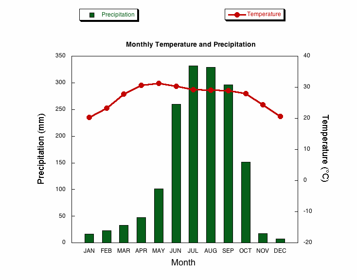
Climograph on:
[Wikipedia]
[Google]
[Amazon]
 A climograph is a
ClimateCharts.net
an interactive climate analysis web platfor
https://doi.org/10.1080/17538947.2020.1829112
(Open Access) *https://climate.mapresso.com/ - Web application for generating climate diagrams for any location on Earth using the free high-resolution CHELSA dataset. Climate and weather statistics Meteorological data and networks Infographics {{climatology-stub
 A climograph is a
 graphic
Graphics () are visual images or designs on some surface, such as a wall, canvas, screen, paper, or stone, to inform, illustrate, or entertain. In contemporary usage, it includes a pictorial representation of the data, as in design and manufa ...
al representation of a location's basic climate
Climate is the long-term weather pattern in a region, typically averaged over 30 years. More rigorously, it is the mean and variability of meteorological variables over a time spanning from months to millions of years. Some of the meteoro ...
. Climographs display data for two variables:
# monthly average temperature
Temperature is a physical quantity that quantitatively expresses the attribute of hotness or coldness. Temperature is measurement, measured with a thermometer. It reflects the average kinetic energy of the vibrating and colliding atoms making ...
# monthly average precipitation
In meteorology, precipitation is any product of the condensation of atmospheric water vapor that falls from clouds due to gravitational pull. The main forms of precipitation include drizzle, rain, rain and snow mixed ("sleet" in Commonwe ...
.
These are useful tools to quickly describe a location's climate
Climate is the long-term weather pattern in a region, typically averaged over 30 years. More rigorously, it is the mean and variability of meteorological variables over a time spanning from months to millions of years. Some of the meteoro ...
.
Representation
While temperature is typically visualized using a line, some climographs opt to visualize the data using a bar. This method's advantage allows the climograph to display the average range in temperature (average minimum and average maximum temperatures) rather than a simple monthly average.Use
The patterns in a climograph describe not just a location's climate but also provide evidence for that climate's relative geographical location. For example, a climograph with a narrow range in temperature over the year might represent a location close to the equator, or alternatively a location adjacent to a large body of water exerting a moderating effect on the temperature range. Meanwhile, a wide range in annual temperature might suggest the opposite. We could also derive information about a site's ecological conditions through a climograph. For example, if precipitation is consistently low year-round, we might suggest the location reflects a desert; if there is a noticeable seasonal pattern to the precipitation, we might suggest the location experiences a monsoon season. When combining the temperature and precipitation patterns together, we have even better clues as to the local conditions. Despite this, a number of local factors contribute to the patterns observed in a particular place; therefore, a climograph is not a foolproof tool that captures all the geographic variation that might exist.References
External links
* *https://climatecharts.net/ - Webapplication for generating climographs for places worldwide dynamically.ClimateCharts.net
an interactive climate analysis web platfor
https://doi.org/10.1080/17538947.2020.1829112
(Open Access) *https://climate.mapresso.com/ - Web application for generating climate diagrams for any location on Earth using the free high-resolution CHELSA dataset. Climate and weather statistics Meteorological data and networks Infographics {{climatology-stub