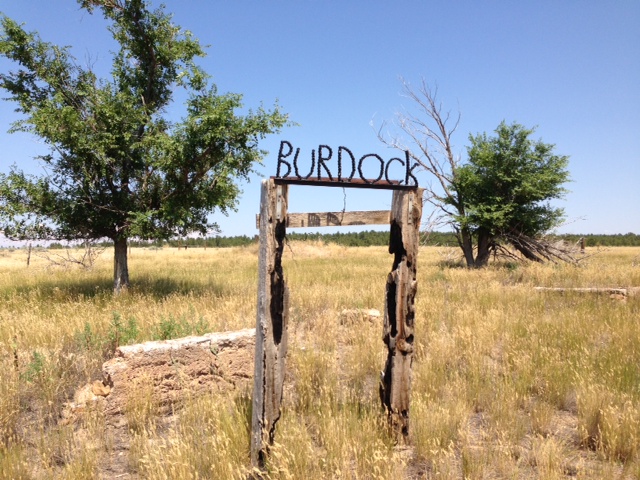
Burdock, South Dakota on:
[Wikipedia]
[Google]
[Amazon]
Burdock is an uninhabited

ghost town
A ghost town, deserted city, extinct town, or abandoned city is an abandoned settlement, usually one that contains substantial visible remaining buildings and infrastructure such as roads. A town often becomes a ghost town because the economi ...
in Argentine Township in Fall River County, South Dakota
South Dakota (; Sioux language, Sioux: , ) is a U.S. state, state in the West North Central states, North Central region of the United States. It is also part of the Great Plains. South Dakota is named after the Dakota people, Dakota Sioux ...
, United States.
According to the Federal Writers' Project
The Federal Writers' Project (FWP) was a federal government project in the United States created to provide jobs for out-of-work writers and to develop a history and overview of the United States, by state, cities and other jurisdictions. It was ...
, the origin of the name Burdock is obscure.
Geography
At this location is the intersection of Fall River County Highway 6463 (Dewey Road) and Township Road B (Argentine Road and Burdock Road). ABNSF Railway
BNSF Railway is the largest freight railroad in the United States. One of six North American Class I railroads, BNSF has 36,000 employees, of track in 28 states, and over 8,000 locomotives. It has three Transcontinental railroad, transcontine ...
line parallels the county highway. In the county's square mile designation, Burdock is closest to 103rd Avenue and 273rd Street. Burdock's nearest neighbors are Dewey to the northwest and Edgemont to the southeast. The border with the state of Wyoming
Wyoming ( ) is a landlocked U.S. state, state in the Mountain states, Mountain West subregion of the Western United States, Western United States. It borders Montana to the north and northwest, South Dakota and Nebraska to the east, Idaho t ...
is three miles west, and the Black Hills National Forest
Black Hills National Forest is located in southwestern South Dakota and northeastern Wyoming, United States. The forest has an area of over 1.25 million acres (5,066 km2) and is managed by the Forest Service. Forest headquarters are located ...
extends around the site some three miles to the north, east, and south. The ghost town lies just to the southwest of the Elk Mountains, a small range that is part of the Black Hills. Burdock appears on the South Dakota highway map and Black Hills National Forest map.
Industry
Uranium
Uranium is a chemical element; it has chemical symbol, symbol U and atomic number 92. It is a silvery-grey metal in the actinide series of the periodic table. A uranium atom has 92 protons and 92 electrons, of which 6 are valence electrons. Ura ...
was found in the area in 1952. It was first produced as early as 1954 by a local group known as Triangle Mining Co., a subsidiary of Edgemont Mining Co. Production consisted of a single, shallow open pit
Open-pit mining, also known as open-cast or open-cut mining and in larger contexts mega-mining, is a surface mining technique that extracts rock or minerals from the earth.
Open-pit mines are used when deposits of commercially useful ore or ...
. Triangle Mining also drove an adit
An adit (from Latin ''aditus'', entrance) or stulm
is a horizontal or nearly horizontal passage to an underground mine.
Miners can use adits for access, drainage, ventilation, and extracting minerals at the lowest convenient level. Adits are a ...
from both sides of an exposed ridge to mine a narrow orebody. In about 1960 Susquehanna Western Corp discovered shallow resources sufficient to warrant open pit mining in five or six pits less than 100' deep. Production is estimated to have been approximately 200,000 lbs of uranium oxide
Uranium oxide is an oxide of the element uranium.
The metal uranium forms several oxides:
* Uranium dioxide or uranium(IV) oxide (UO2, the mineral uraninite or pitchblende)
* Diuranium pentoxide or uranium(V) oxide (U2O5)
* Uranium trioxide or ...
. In early 2012, Powertech (USA) Inc. (now called Azarga Uranium Corp.) submitted a proposal to the U.S. Bureau of Land Management
The Bureau of Land Management (BLM) is an agency within the United States Department of the Interior responsible for administering federal lands, U.S. federal lands. Headquartered in Washington, D.C., the BLM oversees more than of land, or one ...
to begin mining again.Olin M. Hart (1968) "Uranium in the Black Hills", in ''Ore Deposits in the United States, 1933-1967'', New York: American Institute of Mining Engineers, p.832-837.
References
{{Fall River County, South Dakota Geography of Fall River County, South Dakota Ghost towns in South Dakota Black Hills