|
Tectonophysics
Tectonophysics, a branch of geophysics, is the study of the physical processes that underlie tectonic deformation. The field encompasses the spatial patterns of stress, strain, and differing rheologies in the lithosphere and asthenosphere of the Earth; and the relationships between these patterns and the observed patterns of deformation due to plate tectonics. Overview Tectonophysics is concerned with movements in the Earth's crust and deformations over scales from meters to thousands of kilometers. Examples of such processes include mountain building, the formation of sedimentary basins, postglacial rebound of regions such as Fennoscandia, plate tectonics, volcanoes and earthquakes. This involves the measurement of a hierarchy of strains in rocks and plates as well as deformation rates; the study of laboratory analogues of natural systems; and the construction of models for the history of deformation. History Tectonophysics was adopted as the name of a new section of AGU ... [...More Info...] [...Related Items...] OR: [Wikipedia] [Google] [Baidu] |
Tectonophysics (journal)
''Tectonophysics, The International Journal of Geotectonics and the Geology and Physics of the Interior of the Earth'' is a weekly peer-reviewed scientific journal published by Elsevier. It was established in 1964 and covers the field of tectonophysics, including kinematics, structure, composition, and dynamics of the solid Earth at all scales. Organization The editors-in-chief are Philippe Agard (Pierre and Marie Curie University), Jean-Philippe Avouac (California Institute of Technology), Ramon Carbonell (Spanish National Research Council), Rob Govers (Utrecht University), Zheng Xiang Li (Curtin University), and Kelin Wang (Geological Survey of Canada). Abstracting and indexing This journal is abstracted and indexed in over fifty databases, including Current Contents, GeoRef, Inspec, Scopus and Web of Science. Notable articles According to the ''Journal Citation Reports'', ''Tectonophysics'' has a 2011 impact factor The impact factor (IF) or journal impact factor ... [...More Info...] [...Related Items...] OR: [Wikipedia] [Google] [Baidu] |
Plate Tectonics
Plate tectonics (from the la, label= Late Latin, tectonicus, from the grc, τεκτονικός, lit=pertaining to building) is the generally accepted scientific theory that considers the Earth's lithosphere to comprise a number of large tectonic plates which have been slowly moving since about 3.4 billion years ago. The model builds on the concept of '' continental drift'', an idea developed during the first decades of the 20th century. Plate tectonics came to be generally accepted by geoscientists after seafloor spreading was validated in the mid to late 1960s. Earth's lithosphere, which is the rigid outermost shell of the planet (the crust and upper mantle), is broken into seven or eight major plates (depending on how they are defined) and many minor plates or "platelets". Where the plates meet, their relative motion determines the type of plate boundary: '' convergent'', '' divergent'', or '' transform''. Earthquakes, volcanic activity, mountain-building, and ocea ... [...More Info...] [...Related Items...] OR: [Wikipedia] [Google] [Baidu] |
Geophysics
Geophysics () is a subject of natural science concerned with the physical processes and physical properties of the Earth and its surrounding space environment, and the use of quantitative methods for their analysis. The term ''geophysics'' sometimes refers only to solid earth applications: Earth's shape; its gravitational and magnetic fields; its internal structure and composition; its dynamics and their surface expression in plate tectonics, the generation of magmas, volcanism and rock formation. However, modern geophysics organizations and pure scientists use a broader definition that includes the water cycle including snow and ice; fluid dynamics of the oceans and the atmosphere; electricity and magnetism in the ionosphere and magnetosphere and solar-terrestrial physics; and analogous problems associated with the Moon and other planets. Gutenberg, B., 1929, Lehrbuch der Geophysik. Leipzig. Berlin (Gebruder Borntraeger). Runcorn, S.K, (editor-in-chief), 1967, Interna ... [...More Info...] [...Related Items...] OR: [Wikipedia] [Google] [Baidu] |
Fold (geology)
In structural geology, a fold is a stack of originally planar surfaces, such as sedimentary strata, that are bent or curved during permanent deformation. Folds in rocks vary in size from microscopic crinkles to mountain-sized folds. They occur as single isolated folds or in periodic sets (known as ''fold trains''). Synsedimentary folds are those formed during sedimentary deposition. Folds form under varied conditions of stress, pore pressure, and temperature gradient, as evidenced by their presence in soft sediments, the full spectrum of metamorphic rocks, and even as primary flow structures in some igneous rocks. A set of folds distributed on a regional scale constitutes a fold belt, a common feature of orogenic zones. Folds are commonly formed by shortening of existing layers, but may also be formed as a result of displacement on a non-planar fault (''fault bend fold''), at the tip of a propagating fault (''fault propagation fold''), by differential compaction or due ... [...More Info...] [...Related Items...] OR: [Wikipedia] [Google] [Baidu] |
National Academies
A national academy is an organizational body, usually operating with state financial support and approval, that co-ordinates scholarly research activities and standards for academic disciplines, most frequently in the sciences but also the humanities. Typically the country's learned societies in individual disciplines will liaise with or be co-ordinated by the national academy. National academies play an important organisational role in academic exchanges and collaborations between countries. The extent of official recognition of national academies varies between countries. In some cases they are explicitly or de facto an arm of government; in others, as in the United Kingdom, they are voluntary, non-profit bodies with which government has agreed to negotiate, and which may receive government financial support while retaining substantial independence. In some countries, a single academy covers all disciplines; an example is France. In others, there are several academies, which w ... [...More Info...] [...Related Items...] OR: [Wikipedia] [Google] [Baidu] |
Structural Geology
Structural geology is the study of the three-dimensional distribution of rock units with respect to their deformational histories. The primary goal of structural geology is to use measurements of present-day rock geometries to uncover information about the history of deformation ( strain) in the rocks, and ultimately, to understand the stress field that resulted in the observed strain and geometries. This understanding of the dynamics of the stress field can be linked to important events in the geologic past; a common goal is to understand the structural evolution of a particular area with respect to regionally widespread patterns of rock deformation (e.g., mountain building, rifting) due to plate tectonics. Use and importance The study of geologic structures has been of prime importance in economic geology, both petroleum geology and mining geology. Folded and faulted rock strata commonly form traps that accumulate and concentrate fluids such as petroleum and natural gas ... [...More Info...] [...Related Items...] OR: [Wikipedia] [Google] [Baidu] |
Seafloor Spreading
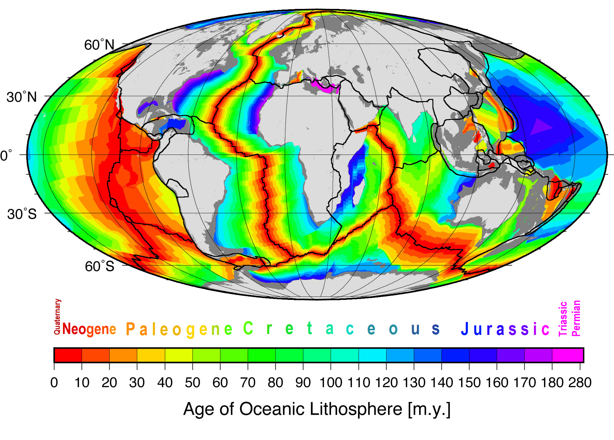
Seafloor spreading or Seafloor spread is a process that occurs at mid-ocean ridges, where new oceanic crust is formed through volcanic activity and then gradually moves away from the ridge. History of study Earlier theories by Alfred Wegener and Alexander du Toit of continental drift postulated that continents in motion "plowed" through the fixed and immovable seafloor. The idea that the seafloor itself moves and also carries the continents with it as it spreads from a central rift axis was proposed by Harold Hammond Hess from Princeton University and Robert Dietz of the U.S. Naval Electronics Laboratory in San Diego in the 1960s. The phenomenon is known today as plate tectonics. In locations where two plates move apart, at mid-ocean ridges, new seafloor is continually formed during seafloor spreading. Significance Seafloor spreading helps explain continental drift in the theory of plate tectonics. When oceanic plates diverge, tensional stress causes fractures to occu ... [...More Info...] [...Related Items...] OR: [Wikipedia] [Google] [Baidu] |
Rock Mechanics
Rock mechanics is a theoretical and applied science of the mechanical behavior of rock and rock masses; compared to geology, it is that branch of mechanics concerned with the response of rock and rock masses to the force fields of their physical environment. 

[...More Info...] [...Related Items...] OR: [Wikipedia] [Google] [Baidu] |
Palaeogeography
Palaeogeography (or paleogeography) is the study of historical geography, generally physical landscapes. Palaeogeography can also include the study of human or cultural environments. When the focus is specifically on landforms, the term paleogeomorphology is sometimes used instead. Paleomagnetism, paleobiogeography, and tectonic history are among its main tools. Palaeogeography yields information that is crucial to scientific understanding in a variety of contexts. For example, palaeogeographical analysis of sedimentary basins plays a key role in the field of petroleum geology, because ancient geomorphological environments of the Earth's surface are preserved in the stratigraphic record. Palaeogeographers also study the sedimentary environment associated with fossils for clues to the evolutionary development of extinct species. Palaeogeography is furthermore crucial to the understanding of palaeoclimatology, due to the impact of the positions of continents and oceans on ... [...More Info...] [...Related Items...] OR: [Wikipedia] [Google] [Baidu] |
Geodynamics
Geodynamics is a subfield of geophysics dealing with dynamics of the Earth. It applies physics, chemistry and mathematics to the understanding of how mantle convection leads to plate tectonics and geologic phenomena such as seafloor spreading, mountain building, volcanoes, earthquakes, faulting. It also attempts to probe the internal activity by measuring magnetic fields, gravity, and seismic waves, as well as the mineralogy of rocks and their isotopic composition. Methods of geodynamics are also applied to exploration of other planets. Overview Geodynamics is generally concerned with processes that move materials throughout the Earth. In the Earth's interior, movement happens when rocks melt or deform and flow in response to a stress field.Turcotte, D. L. and G. Schubert (2014). "Geodynamics." This deformation may be brittle, elastic, or plastic, depending on the magnitude of the stress and the material's physical properties, especially the stress relaxation time ... [...More Info...] [...Related Items...] OR: [Wikipedia] [Google] [Baidu] |
Academy Of Sciences Of The USSR
The Academy of Sciences of the Soviet Union was the highest scientific institution of the Soviet Union from 1925 to 1991, uniting the country's leading scientists, subordinated directly to the Council of Ministers of the Soviet Union (until 1946 – to the Council of People's Commissars of the Soviet Union). In 1991, by the decree of the President of the Russian Soviet Federative Socialist Republic, the Russian Academy of Sciences was established on the basis of the Academy of Sciences of the Soviet Union. History Creation of the Academy of Sciences of the Soviet Union The Academy of Sciences of the Soviet Union was formed by a resolution of the Central Executive Committee and the Council of People's Commissars of the Soviet Union dated July 27, 1925 on the basis of the Russian Academy of Sciences (before the February Revolution – the Imperial Saint Petersburg Academy of Sciences). In the first years of Soviet Russia, the Institute of the Academy of Sciences was perceived rat ... [...More Info...] [...Related Items...] OR: [Wikipedia] [Google] [Baidu] |
Earth's Crust
Earth's crust is Earth's thin outer shell of rock, referring to less than 1% of Earth's radius and volume. It is the top component of the lithosphere, a division of Earth's layers that includes the crust and the upper part of the mantle. The lithosphere is broken into tectonic plates whose motion allows heat to escape from the interior of the Earth into space. The crust lies on top of the mantle, a configuration that is stable because the upper mantle is made of peridotite and is therefore significantly denser than the crust. The boundary between the crust and mantle is conventionally placed at the Mohorovičić discontinuity, a boundary defined by a contrast in seismic velocity. The temperature of the crust increases with depth, reaching values typically in the range from about to at the boundary with the underlying mantle. The temperature increases by as much as for every kilometer locally in the upper part of the crust Composition File:Elemental abundances.svg, ... [...More Info...] [...Related Items...] OR: [Wikipedia] [Google] [Baidu] |


