|
Inertial Reference Unit
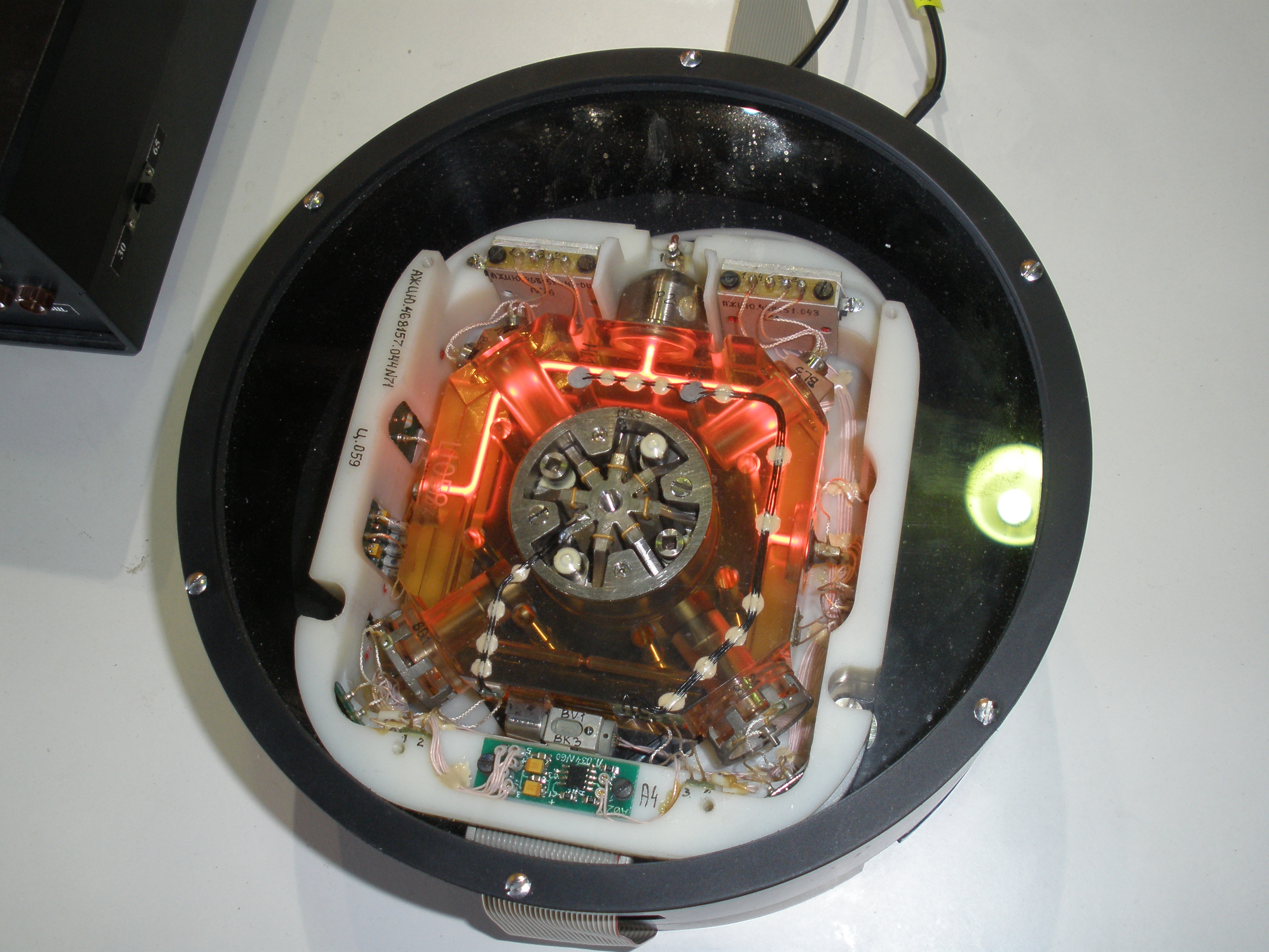
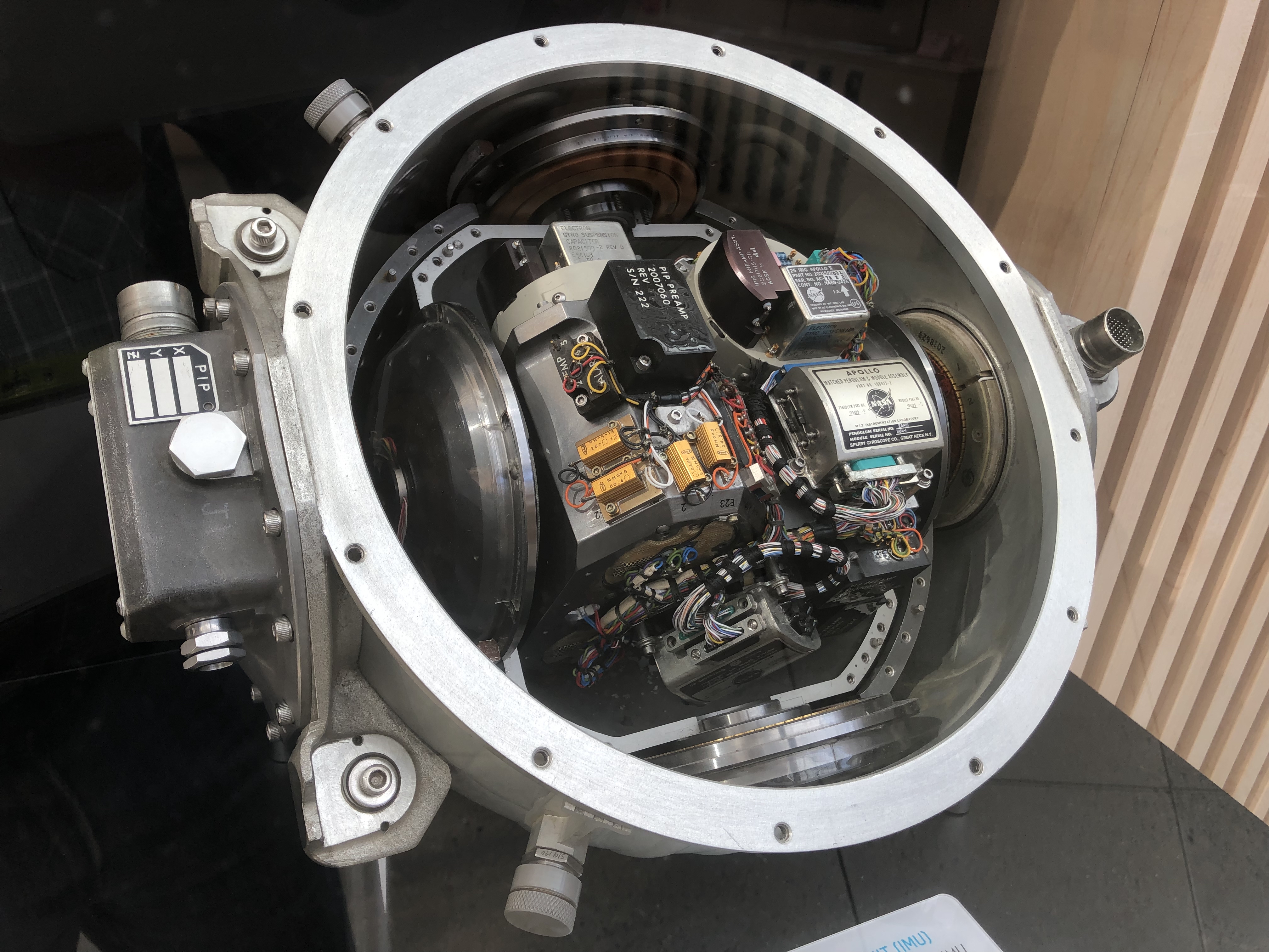
An inertial reference unit (IRU) is a type of inertial sensor which uses gyroscopes (electromechanical, ring laser gyro or MEMS) and accelerometers (electromechanical or MEMS) to determine a moving aircraft’s or spacecraft’s change in rotational attitude (angular orientation relative to some reference frame) and translational position (typically latitude, longitude and altitude) over a period of time. In other words, an IRU allows a device, whether airborne or submarine, to travel from one point to another without reference to external information. Another name often used interchangeably with IRU is Inertial Measurement Unit. The two basic classes of IRUs/IMUs are "gimballed" and "strapdown". The older, larger gimballed systems have become less prevalent over the years as the performance of newer, smaller strapdown systems has improved greatly via the use of solid-state sensors and advanced real-time computer algorithms. Gimballed systems are still used in some high-precision ... [...More Info...] [...Related Items...] OR: [Wikipedia] [Google] [Baidu] |
Inertial Guidance System
An inertial navigation system (INS) is a navigation device that uses motion sensors (accelerometers), rotation sensors ( gyroscopes) and a computer to continuously calculate by dead reckoning the position, the orientation, and the velocity (direction and speed of movement) of a moving object without the need for external references. Often the inertial sensors are supplemented by a barometric altimeter and sometimes by magnetic sensors ( magnetometers) and/or speed measuring devices. INSs are used on mobile robots and on vehicles such as ships, aircraft, submarines, guided missiles, and spacecraft. Other terms used to refer to inertial navigation systems or closely related devices include inertial guidance system, inertial instrument, inertial measurement unit (IMU) and many other variations. Older INS systems generally used an inertial platform as their mounting point to the vehicle and the terms are sometimes considered synonymous. Overview Inertial navigation is a self-cont ... [...More Info...] [...Related Items...] OR: [Wikipedia] [Google] [Baidu] |
Gyroscopes
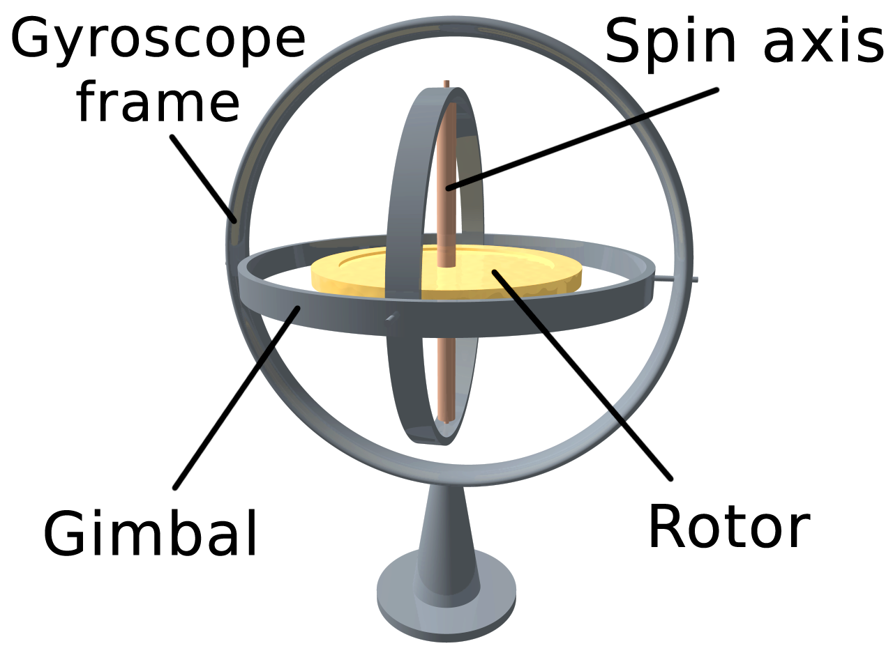
A gyroscope (from Ancient Greek γῦρος ''gŷros'', "round" and σκοπέω ''skopéō'', "to look") is a device used for measuring or maintaining orientation and angular velocity. It is a spinning wheel or disc in which the axis of rotation (spin axis) is free to assume any orientation by itself. When rotating, the orientation of this axis is unaffected by tilting or rotation of the mounting, according to the conservation of angular momentum In physics, angular momentum (rarely, moment of momentum or rotational momentum) is the rotational analog of linear momentum. It is an important physical quantity because it is a conserved quantity—the total angular momentum of a closed system .... Gyroscopes based on other operating principles also exist, such as the microchip-packaged Vibrating structure gyroscope#MEMS gyroscopes, MEMS gyroscopes found in electronic devices (sometimes called gyrometers), solid-state ring laser gyroscope, ring lasers, fibre optic gyroscopes, an ... [...More Info...] [...Related Items...] OR: [Wikipedia] [Google] [Baidu] |
Ring Laser Gyro
A ring laser gyroscope (RLG) consists of a ring laser having two independent counter-propagating resonant modes over the same path; the difference in phase is used to detect rotation. It operates on the principle of the Sagnac effect which shifts the nulls of the internal standing wave pattern in response to angular rotation. Interference between the counter-propagating beams, observed externally, results in motion of the standing wave pattern, and thus indicates rotation. Description The first experimental ring laser gyroscope was demonstrated in the US by Macek and Davis in 1963. Various organizations worldwide subsequently developed ring-laser technology further. Many tens of thousands of RLGs are operating in inertial navigation systems and have established high accuracy, with better than 0.01°/hour bias uncertainty, and mean time between failures in excess of 60,000 hours. Ring laser gyroscopes can be used as the stable elements (for one degree of freedom each) in an ine ... [...More Info...] [...Related Items...] OR: [Wikipedia] [Google] [Baidu] |
MEMS
Microelectromechanical systems (MEMS), also written as micro-electro-mechanical systems (or microelectronic and microelectromechanical systems) and the related micromechatronics and microsystems constitute the technology of microscopic devices, particularly those with moving parts. They merge at the nanoscale into nanoelectromechanical systems (NEMS) and nanotechnology. MEMS are also referred to as micromachines in Japan and microsystem technology (MST) in Europe. MEMS are made up of components between 1 and 100 micrometers in size (i.e., 0.001 to 0.1 mm), and MEMS devices generally range in size from 20 micrometres to a millimetre (i.e., 0.02 to 1.0 mm), although components arranged in arrays (e.g., digital micromirror devices) can be more than 1000 mm2. They usually consist of a central unit that processes data (an integrated circuit chip such as microprocessor) and several components that interact with the surroundings (such as microsensors). Because of the la ... [...More Info...] [...Related Items...] OR: [Wikipedia] [Google] [Baidu] |
Accelerometers
An accelerometer is a tool that measures proper acceleration. Proper acceleration is the acceleration (the rate of change of velocity) of a body in its own instantaneous rest frame; this is different from coordinate acceleration, which is acceleration in a fixed coordinate system. For example, an accelerometer at rest on the surface of the Earth will measure an acceleration due to Earth's gravity, straight upwards (by definition) of g ≈ 9.81 m/s2. By contrast, accelerometers in free fall (falling toward the center of the Earth at a rate of about 9.81 m/s2) will measure zero. Accelerometers have many uses in industry and science. Highly sensitive accelerometers are used in inertial navigation systems for aircraft and missiles. Vibration in rotating machines is monitored by accelerometers. They are used in tablet computers and digital cameras so that images on screens are always displayed upright. In unmanned aerial vehicles, accelerometers help to stabilise flight. W ... [...More Info...] [...Related Items...] OR: [Wikipedia] [Google] [Baidu] |
Aircraft
An aircraft is a vehicle that is able to fly by gaining support from the air. It counters the force of gravity by using either static lift or by using the dynamic lift of an airfoil, or in a few cases the downward thrust from jet engines. Common examples of aircraft include airplanes, helicopters, airships (including blimps), gliders, paramotors, and hot air balloons. The human activity that surrounds aircraft is called ''aviation''. The science of aviation, including designing and building aircraft, is called '' aeronautics.'' Crewed aircraft are flown by an onboard pilot, but unmanned aerial vehicles may be remotely controlled or self-controlled by onboard computers. Aircraft may be classified by different criteria, such as lift type, aircraft propulsion, usage and others. History Flying model craft and stories of manned flight go back many centuries; however, the first manned ascent — and safe descent — in modern times took place by larger hot-air ... [...More Info...] [...Related Items...] OR: [Wikipedia] [Google] [Baidu] |
Spacecraft
A spacecraft is a vehicle or machine designed to fly in outer space. A type of artificial satellite, spacecraft are used for a variety of purposes, including communications, Earth observation, meteorology, navigation, space colonization, planetary exploration, and transportation of humans and cargo. All spacecraft except single-stage-to-orbit vehicles cannot get into space on their own, and require a launch vehicle (carrier rocket). On a sub-orbital spaceflight, a space vehicle enters space and then returns to the surface without having gained sufficient energy or velocity to make a full Earth orbit. For orbital spaceflights, spacecraft enter closed orbits around the Earth or around other celestial bodies. Spacecraft used for human spaceflight carry people on board as crew or passengers from start or on orbit (space stations) only, whereas those used for robotic space missions operate either autonomously or telerobotically. Robotic spacecraft used to support scientific re ... [...More Info...] [...Related Items...] OR: [Wikipedia] [Google] [Baidu] |
Latitude
In geography, latitude is a coordinate that specifies the north– south position of a point on the surface of the Earth or another celestial body. Latitude is given as an angle that ranges from –90° at the south pole to 90° at the north pole, with 0° at the Equator. Lines of constant latitude, or ''parallels'', run east–west as circles parallel to the equator. Latitude and ''longitude'' are used together as a coordinate pair to specify a location on the surface of the Earth. On its own, the term "latitude" normally refers to the ''geodetic latitude'' as defined below. Briefly, the geodetic latitude of a point is the angle formed between the vector perpendicular (or ''normal'') to the ellipsoidal surface from the point, and the plane of the equator. Background Two levels of abstraction are employed in the definitions of latitude and longitude. In the first step the physical surface is modeled by the geoid, a surface which approximates the mean sea level over the ocean ... [...More Info...] [...Related Items...] OR: [Wikipedia] [Google] [Baidu] |
Longitude
Longitude (, ) is a geographic coordinate that specifies the east–west position of a point on the surface of the Earth, or another celestial body. It is an angular measurement, usually expressed in degrees and denoted by the Greek letter lambda (λ). Meridians are semicircular lines running from pole to pole that connect points with the same longitude. The prime meridian defines 0° longitude; by convention the International Reference Meridian for the Earth passes near the Royal Observatory in Greenwich, England on the island of Great Britain. Positive longitudes are east of the prime meridian, and negative ones are west. Because of the Earth's rotation, there is a close connection between longitude and time measurement. Scientifically precise local time varies with longitude: a difference of 15° longitude corresponds to a one-hour difference in local time, due to the differing position in relation to the Sun. Comparing local time to an absolute measure of time allows ... [...More Info...] [...Related Items...] OR: [Wikipedia] [Google] [Baidu] |
Altitude
Altitude or height (also sometimes known as depth) is a distance measurement, usually in the vertical or "up" direction, between a reference datum and a point or object. The exact definition and reference datum varies according to the context (e.g., aviation, geometry, geographical survey, sport, or atmospheric pressure). Although the term ''altitude'' is commonly used to mean the height above sea level of a location, in geography the term elevation is often preferred for this usage. Vertical distance measurements in the "down" direction are commonly referred to as depth. In aviation In aviation, the term altitude can have several meanings, and is always qualified by explicitly adding a modifier (e.g. "true altitude"), or implicitly through the context of the communication. Parties exchanging altitude information must be clear which definition is being used. Aviation altitude is measured using either mean sea level (MSL) or local ground level (above ground level, or ... [...More Info...] [...Related Items...] OR: [Wikipedia] [Google] [Baidu] |
Peacekeeper ICBM Inertial Measurement Unit
Peacekeeper may refer to: General * A person involved in peacekeeping ** United Nations peacekeeping * Peace officer * Conservator of the peace Military * The LGM-118 Peacekeeper, a land-based nuclear ICBM ** Peacekeeper Rail Garrison, a mobile missile system for the LGM-118 Peacekeeper * Cadillac Gage Ranger, armored fighting vehicles ** Cadillac Gage Peacekeeper II, one of the two models of the vehicle Fiction * ''The Peacekeepers'', a 1988 ''Star Trek: The Next Generation'' novel by Gene DeWeese * ''The Peacekeeper'', a 1997 Canadian and American action film * Peacekeepers (''Farscape''), a fictional military and law enforcement organization in ''Farscape'' * Peacekeepers (''The Hunger Games''), the combined military and police force in Panem in ''The Hunger Games'' * "Peacekeeper" (''NCIS''), a 2021 television episode * ''Peacekeepers'', a 1988 science fiction novel by Ben Bova Video games * ''The Peace Keepers'', a 1993 video game for the Super Nintendo Entertainm ... [...More Info...] [...Related Items...] OR: [Wikipedia] [Google] [Baidu] |
Inertial Measurement Unit
An inertial measurement unit (IMU) is an electronic device that measures and reports a body's specific force, angular rate, and sometimes the orientation of the body, using a combination of accelerometers, gyroscopes, and sometimes magnetometers. When the magnetometer is included, IMUs are referred to as IMMUs. IMUs are typically used to maneuver modern vehicles including motorcycles, missiles, aircraft (an attitude and heading reference system), including unmanned aerial vehicles (UAVs), among many others, and spacecraft, including satellites and landers. Recent developments allow for the production of IMU-enabled GPS devices. An IMU allows a GPS receiver to work when GPS-signals are unavailable, such as in tunnels, inside buildings, or when electronic interference is present. Operational principles An inertial measurement unit works by detecting linear acceleration using one or more accelerometers and rotational rate using one or more gyroscopes. Some also include a magnetom ... [...More Info...] [...Related Items...] OR: [Wikipedia] [Google] [Baidu] |


