|
Ilok
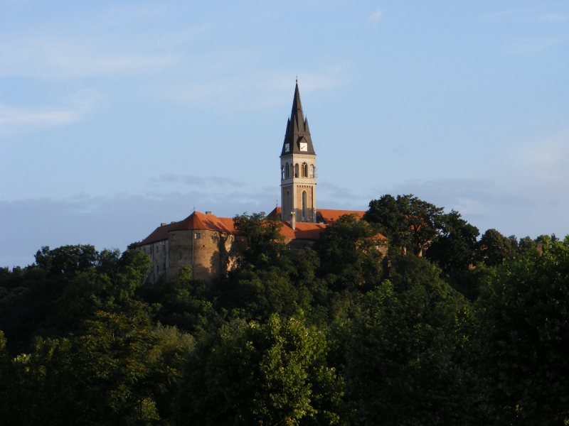
Ilok () is the easternmost town in Croatia forming a geographic salient surrounded by Vojvodina. Located in the Syrmia region, it lies on a hill overlooking the Danube river, which forms the border with the Bačka region of Serbia. The population of the settlement of Ilok is 5,072, while the total town population is 3,407 (census 2021). The town is home to a Franciscan monastery and Ilok Castle, which is a popular day trip for domestic tourists. Name In Croatian, the town is known as ''Ilok'', in German as ''Illok'', in Hungarian as ''Újlak'', in Serbian Cyrillic as Илок and in Turkish as ''Uyluk''. In Hungarian language "Újlak" means "new dwelling or lodge". History The area of present-day Ilok was populated since the neolithic and Bronze Ages. One Scordisci archaeological site dating back to late La Tène culture was excavated in the 1970s and 1980s as a part of rescue excavations in eastern Croatia. The Romans settled there in the 1st or 2nd century and buil ... [...More Info...] [...Related Items...] OR: [Wikipedia] [Google] [Baidu] |
Ilok Castle
Ilok Castle ( hr, Iločki dvorac or ''Gradina Ilok'') or Odescalchi Castle overlooks the town of Ilok in eastern Croatia. It is built on a hill above the town centre, offering views on the Danube and the Pannonian Plain. The castle was originally built in the 15th century by Nicholas of Ilok, Croatian viceroy and the king of Bosnia. The Ottomans conquered Ilok in the 16th century. After the victory against the Ottomans at the Battle of Vienna in 1683, the Emperor Leopold I granted the castle, significant properties and the title of the Duke of Syrmia to Livio Odescalchi, nephew of Pope Innocent XI and a member of the powerful Italian aristocratic Odescalchi family, which would own the castle for the next two centuries. In the 18th century, the Odescalchis reconstructed the castle in the Baroque style. The castle was nationalized by authorities of Yugoslavia Yugoslavia (; sh-Latn-Cyrl, separator=" / ", Jugoslavija, Југославија ; sl, Jugoslavija ; mk, Југ ... [...More Info...] [...Related Items...] OR: [Wikipedia] [Google] [Baidu] |
Syrmia
Syrmia ( sh, Srem/Срем or sh, Srijem/Сријем, label=none) is a region of the southern Pannonian Plain, which lies between the Danube and Sava rivers. It is divided between Serbia and Croatia. Most of the region is flat, with the exception of the low Fruška gora mountain stretching along the Danube in its northern part. Etymology The word "Syrmia" is derived from the ancient city of Sirmium (now Sremska Mitrovica). Sirmium was a Celtic or Illyrian town founded in the third century BC. ''Srem'' ( sr-cyr, Срем) and ''Srijem'' are used to designate the region in Serbia and Croatia respectively. Other names for the region include: * Latin: ''Syrmia'' or ''Sirmium'' * Hungarian: ''Szerémség'', ''Szerém'', or ''Szerémország'' * German: ''Syrmien'' * Slovak: ''Sriem'' * Rusyn: Срим * Romanian: ''Sirmia'' History Prehistory Between 3000 BC and 2400 BC, Syrmia was at the centre of Indo-European Vučedol culture. Roman era Sirmium was c ... [...More Info...] [...Related Items...] OR: [Wikipedia] [Google] [Baidu] |
Podunavlje
Podunavlje ( sr-Cyrl, Подунавље) is the name of the Danube river basin parts located in Serbia ( Vojvodina, Belgrade and Eastern Serbia) and Croatia (Slavonia, Syrmia, and Baranya). Podunavlje is located on the southern edge of Pannonian Basin. In its wider meaning, the Serbo-Croatian term refers to the area around the entire flow of the river Danube. Naming history In the first half of the 18th century, Sava-Danube ( Posavina-Podunavlje) section of the Habsburg Military Frontier existed in the area. Podunavlje segment of the Frontier comprised parts of southern Bačka and northern Syrmia including towns of Petrovaradin, Šid, Bačka Palanka, Bački Petrovac, Petrovaradinski Šanac (Novi Sad), and Titel. Between 1922 and 1929, Podunavlje Oblast was one of the administrative units of the Kingdom of Serbs, Croats and Slovenes. It included parts of Šumadija and Banat regions and its seat was in Smederevo. Between 1929 and 1941, one of the provinces of t ... [...More Info...] [...Related Items...] OR: [Wikipedia] [Google] [Baidu] |
Danube
The Danube ( ; ) is a river that was once a long-standing frontier of the Roman Empire and today connects 10 European countries, running through their territories or being a border. Originating in Germany, the Danube flows southeast for , passing through or bordering Austria, Slovakia, Hungary, Croatia, Serbia, Romania, Bulgaria, Moldova, and Ukraine before draining into the Black Sea. Its drainage basin extends into nine more countries. The largest cities on the river are Vienna, Budapest, Belgrade and Bratislava, all of which are the capitals of their respective countries; the Danube passes through four capital cities, more than any other river in the world. Five more capital cities lie in the Danube's basin: Bucharest, Sofia, Zagreb, Ljubljana and Sarajevo. The fourth-largest city in its basin is Munich, the capital of Bavaria, standing on the Isar River. The Danube is the second-longest river in Europe, after the Volga in Russia. It flows through much of C ... [...More Info...] [...Related Items...] OR: [Wikipedia] [Google] [Baidu] |
Salient (geography)
A salient (also known as a panhandle or bootheel) is an elongated protrusion of a geopolitical entity, such as a subnational entity or a sovereign state. While similar to a peninsula in shape, a salient is most often not surrounded by water on three sides. Instead, it has a land border on at least two sides and extends from the larger geographical body of the administrative unit. In American English, the term panhandle is often used to describe a relatively long and narrow salient, such as the westernmost extensions of Florida and Oklahoma. Another term is bootheel, used for the Missouri Bootheel and New Mexico Bootheel areas. Origin The term ''salient'' is derived from military salients. The term "panhandle" derives from the analogous part of a cooking pan, and its use is generally confined to North America. The salient shape can be the result of arbitrarily drawn international or subnational boundaries, though the location of administrative borders can also take into acc ... [...More Info...] [...Related Items...] OR: [Wikipedia] [Google] [Baidu] |
List Of Cities And Towns In Croatia An urbanized area in Croatia can gain the status of ''grad'' (which can be translated as town or city as there is no distin |


.jpg)