|
Dust Devil Tracks
Martian dust devils (dust devils on Mars) were first photographed by the Viking orbiters in the 1970s. In 1997, the Mars Pathfinder lander detected a dust devil passing over it. In the first image below, photographed by the Mars Global Surveyor, the long dark streak is formed by a moving swirling column of Martian atmosphere. The dust devil itself (the black spot) is climbing the crater wall. The streaks on the right are sand dunes on the crater floor. Martian dust devils can be up to fifty times as wide and ten times as high as terrestrial dust devils, and large ones may pose a threat to terrestrial technology sent to Mars. On 7 November 2016, five such dust devils ranging in heights of 0.5 to 1.9 km were imaged in a single observation by the Mars Orbiter Mission in the Martian southern hemisphere. Mission members monitoring the Spirit rover on Mars reported on March 12, 2005, that a lucky encounter with a dust devil had cleaned the solar panels of that robot. Power levels ... [...More Info...] [...Related Items...] OR: [Wikipedia] [Google] [Baidu] |
Valles Marineris
Valles Marineris (; Latin for ''Mariner program, Mariner Valleys'', named after the ''Mariner 9'' Mars orbiter of 1971–72 which discovered it) is a system of canyons that runs along the Mars, Martian surface east of the Tharsis region. At more than long, wide and up to deep, Valles Marineris is one of the largest List of largest rifts and valleys in the Solar System, canyons of the Solar System, surpassed in length only by the rift valleys of the mid-ocean ridge system of Earth. Valles Marineris is located along the equator of Mars, on the east side of the Tharsis Bulge, and stretches for nearly a quarter of the planet's circumference. The canyon system starts in the west with Noctis Labyrinthus; proceeding to the east are Tithonium Chasma, Tithonium and Ius Chasma, Ius chasmata, then Melas Chasma, Melas, Candor Chasma, Candor and Ophir Chasma, Ophir chasmata, then Coprates Chasma, then Ganges Chasma, Ganges, Capri Chasma, Capri and Eos Chasma, Eos chasmata; finally it emptie ... [...More Info...] [...Related Items...] OR: [Wikipedia] [Google] [Baidu] |
Geology Of Mars
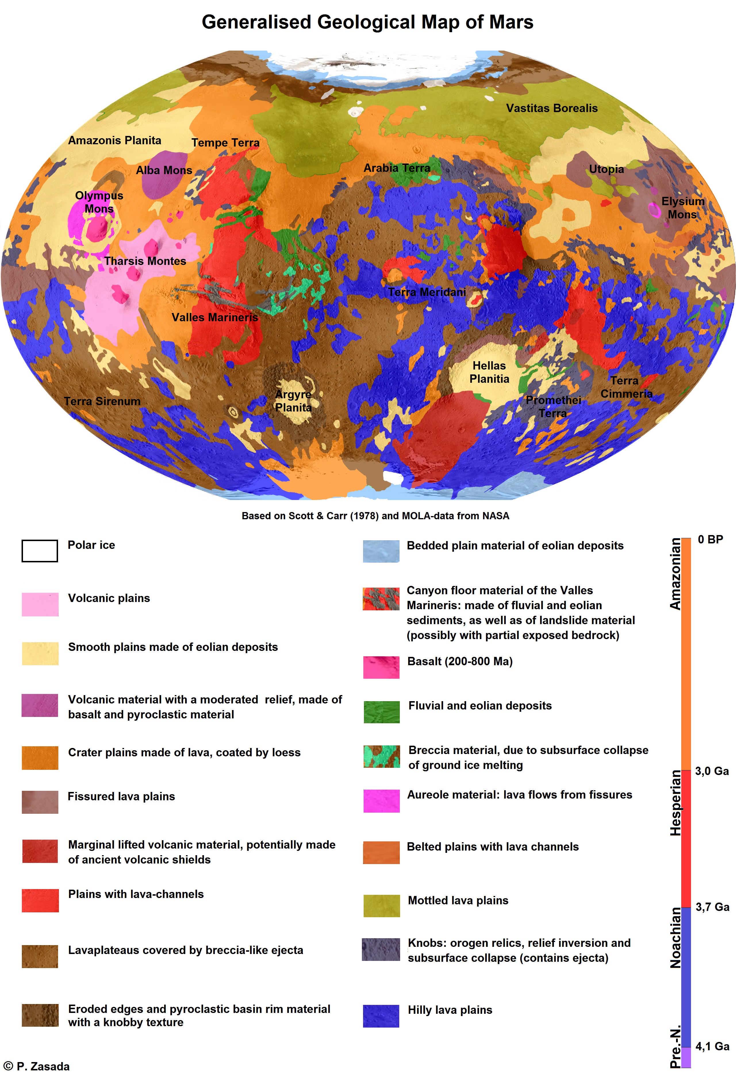
The geology of Mars is the scientific study of the surface, crust, and interior of the planet Mars. It emphasizes the composition, structure, history, and physical processes that shape the planet. It is analogous to the field of terrestrial geology. In planetary science, the term ''geology'' is used in its broadest sense to mean the study of the solid parts of planets and moons. The term incorporates aspects of geophysics, geochemistry, mineralogy, geodesy, and cartography. A neologism, areology, from the Greek word ''Arēs'' (Mars), sometimes appears as a synonym for Mars's geology in the popular media and works of science fiction (e.g. Kim Stanley Robinson, Kim Stanley Robinson's Mars trilogy). The term areology is also used by the Areological Society. Geological map of Mars (2014) File:Geologic Map of Mars figure2.pdf, Figure 2 for the geologic map of Mars Global Martian topography and large-scale features Composition of Mars Mars is a terrestrial planet, whic ... [...More Info...] [...Related Items...] OR: [Wikipedia] [Google] [Baidu] |
Dark Slope Streaks
Dark slope streaks are narrow, avalanche-like features common on dust-covered slopes in the equatorial regions of Mars.Chuang, F.C.; Beyer, R.A.; Bridges, N.T. (2010). Modification of Martian Slope Streaks by Eolian Processes. ''Icarus,'' 205 154–164. They form in relatively steep terrain, such as along escarpments and crater walls.Schorghofer, N.; Aharonson, O.; Khatiwala, S. (2002). Slope Streaks on Mars: Correlations with Surface Properties and the Potential Role of Water. ''Geophys. Res. Lett.,'' 29(23), 2126, . Although first recognized in Viking Orbiter images from the late 1970s,Morris, E.C. (1982). Aureole Deposits of the Martian Volcano Olympus Mons. ''J. Geophys. Res.,'' 87(B2), 1164–1178.Ferguson, H.M.; Lucchitta, B.K. (1984). Dark Streaks on Talus Slopes, Mars in ''Reports of the Planetary Geology Program 1983, NASA Tech. Memo., TM-86246,'' pp. 188–190. https://ntrs.nasa.gov/archive/nasa/casi.ntrs.nasa.gov/19840015363_1984015363.pdf. dark slope streaks were not s ... [...More Info...] [...Related Items...] OR: [Wikipedia] [Google] [Baidu] |
Amazonis Planitia
Amazonis Planitia (, Latin ''Amāzŏnis'') is one of the smoothest plains on Mars. It is located between the Tharsis and Elysium volcanic provinces, to the west of Olympus Mons, in the Amazonis and Memnonia quadrangles, centered at . The plain's topography exhibits extremely smooth features at several different lengths of scale. A large part of the Medusae Fossae Formation lies in Amazonis Planitia. Its name derives from one of the classical albedo features observed by early astronomers, which was in turn named after the Amazons, a mythical race of warrior women. Age and composition Only approximately 100 million years old, these plains provide some of the fewest sedimentary layers impeding viewing of the Martian terrain, and closely resemble the composition of Earth's Iceland. Formed by free-flowing lava across great plains, Amazonis has been described by William Hartmann as a "bright dusty volcanic desert crossed by many fresh-looking lava flows." Amazonis has become the ... [...More Info...] [...Related Items...] OR: [Wikipedia] [Google] [Baidu] |
Jezero (Martian Crater)
Jezero is a crater on Mars in the Syrtis Major quadrangle, about in diameter. Thought to have once been flooded with water, the crater contains a fan-delta deposit rich in clays. The lake in the crater was present when valley networks were forming on Mars. Besides having a delta, the crater shows point bars and inverted channels. From a study of the delta and channels, it was concluded that the lake inside the crater probably formed during a period in which there was continual surface runoff. In 2007, following the discovery of its ancient lake, the crater was named after Jezero, Bosnia and Herzegovina, one of several eponymous towns in the country. In some Slavic languages, the word , sh-Latn-Cyrl, jezero, језеро, separator=" / ", Czech, sl, jezero and its closest written variations ( pl, jezioro, dsb, jezer, sk, jazero, Russian and uk, озеро), as well as in Baltic languages ( lt, ežeras, lv, ezers) means 'lake'. In November 2018, it was announced that Jez ... [...More Info...] [...Related Items...] OR: [Wikipedia] [Google] [Baidu] |
Jezero (crater)
Jezero is a crater on Mars in the Syrtis Major quadrangle, about in diameter. Thought to have once been flooded with water, the crater contains a fan-delta deposit rich in clays. The lake in the crater was present when valley networks were forming on Mars. Besides having a delta, the crater shows point bars and inverted channels. From a study of the delta and channels, it was concluded that the lake inside the crater probably formed during a period in which there was continual surface runoff. In 2007, following the discovery of its ancient lake, the crater was named after Jezero, Bosnia and Herzegovina, one of several eponymous towns in the country. In some Slavic languages, the word , sh-Latn-Cyrl, jezero, језеро, separator=" / ", Czech, sl, jezero and its closest written variations ( pl, jezioro, dsb, jezer, sk, jazero, Russian and uk, озеро), as well as in Baltic languages ( lt, ežeras, lv, ezers) means 'lake'. In November 2018, it was announced that Jez ... [...More Info...] [...Related Items...] OR: [Wikipedia] [Google] [Baidu] |
Amazonis Quadrangle
The Amazonis quadrangle is one of a series of 30 quadrangle maps of Mars used by the United States Geological Survey (USGS) Astrogeology Research Program. The Amazonis quadrangle is also referred to as MC-8 (Mars Chart-8). The quadrangle covers the area from 135° to 180° west longitude and 0° to 30° north latitude on Mars. The Amazonis quadrangle contains the region called Amazonis Planitia. This area is thought to be among the youngest parts of Mars because it has a very low density of craters. The Amazonian Epoch is named after this area. This quadrangle contains special, unusual features called the Medusae Fossae Formation and Sulci. Medusae Fossae Formation The Amazonis quadrangle is of great interest to scientists because it contains a big part of a formation, called the Medusae Fossae Formation. It is a soft, easily eroded deposit that extends for nearly 1,000 km along the equator of Mars. The surface of the formation has been eroded by the wind into a series ... [...More Info...] [...Related Items...] OR: [Wikipedia] [Google] [Baidu] |
Arabia Quadrangle
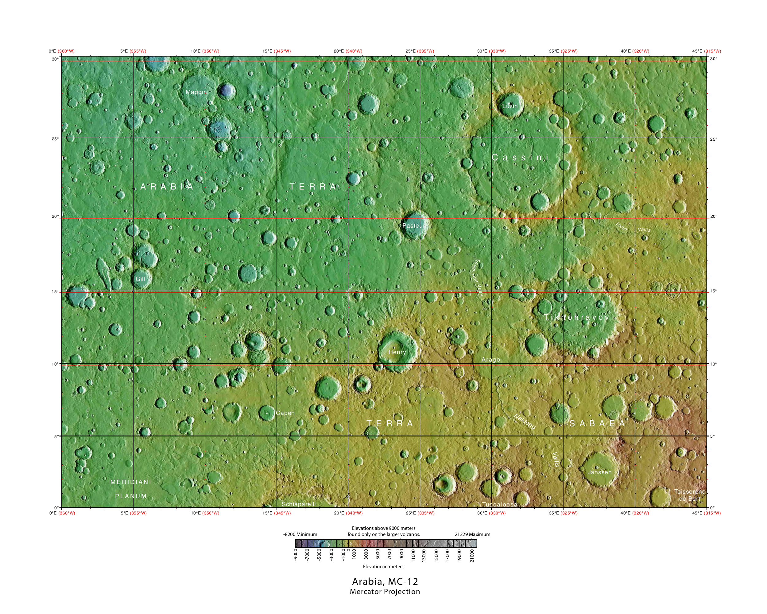
The Arabia quadrangle is one of a series of 30 quadrangle maps of Mars used by the United States Geological Survey (USGS) Astrogeology Research Program. The Arabia quadrangle is also referred to as MC-12 (Mars Chart-12). The quadrangle contains part of the classic area of Mars known as Arabia. It also contains a part of Terra Sabaea and a small part of Meridiani Planum. It lies on the boundary between the young northern plains and the old southern highlands. The quadrangle covers the area from 315° to 360° west longitude and 0° to 30° north latitude. Description The surface of the Arabia quadrangle appears to be very old because it has a high density of craters, but it is not near as high in elevation as typical old surfaces. On Mars the oldest areas contain the most craters; the oldest period is called Noachian after the quadrangle Noachis. The Arabia area contains many buttes and ridges. Some believe that during certain climate changes an ice-dust layer was deposited ... [...More Info...] [...Related Items...] OR: [Wikipedia] [Google] [Baidu] |
Casius Quadrangle
The Casius quadrangle is one of a series of 30 quadrangle maps of Mars used by the United States Geological Survey (USGS) Astrogeology Research Program. The quadrangle is located in the north-central portion of Mars’ eastern hemisphere and covers 60° to 120° east longitude (240° to 300° west longitude) and 30° to 65° north latitude. The quadrangle uses a Lambert conformal conic projection at a nominal scale of 1:5,000,000 (1:5M). The Casius quadrangle is also referred to as MC-6 (Mars Chart-6). Casius quadrangle contains part of Utopia Planitia and a small part of Terra Sabaea. The southern and northern borders of the Casius quadrangle are approximately 3,065 km and 1,500 km wide, respectively. The north to south distance is about 2,050 km (slightly less than the length of Greenland). The quadrangle covers an approximate area of 4.9 million square km, or a little over 3% of Mars’ surface area. Origin of name Casius is the name of a telescopic albedo f ... [...More Info...] [...Related Items...] OR: [Wikipedia] [Google] [Baidu] |
Noachis Quadrangle
The Noachis quadrangle is one of a series of list of quadrangles on Mars, 30 quadrangle maps of Mars used by the United States Geological Survey (USGS) Astrogeology Research Program. The Noachis quadrangle is also referred to as MC-27 (Mars Chart-27). The Noachis quadrangle covers the area from 300° to 360° west longitude and 30° to 65° south latitude on Mars. It lies between the two giant impact basins on Mars: Argyre and Hellas. The Noachis quadrangle includes Noachis Terra and the western part of Hellas Planitia. Noachis is so densely covered with impact craters that it is considered among the oldest landforms on Mars—hence the term "Noachian" for one of the earliest time periods in martian history. In addition, many previously buried craters are now coming to the surface, where Noachis' extreme age has allowed ancient craters to be filled, and once again newly exposed. Much of the surface in Noachis quadrangle shows a scalloped topography where the disappearance of ... [...More Info...] [...Related Items...] OR: [Wikipedia] [Google] [Baidu] |


